upper waypoint

How Serious Is the California Drought? These Satellite Images Say It All

Save ArticleSave Article
Failed to save article

Please try again

0125-SierraNevada_CA_drought
NASA satellite imagery comparing California's snowpack in January 2013 to January 2014. GIF animation created by Rhett A. Butler_Mongabay.com.

If you live in California, snowpack is a pretty crucial part of your existence.

That's because about a third of the state's water supply comes from snow that accumulates in the mountains, mostly during the winter months. In fact, California receives roughly half of its entire year's water supply between December and February alone.

And that's why there is very reasonable cause for alarm this year, as Gov. Jerry Brown underscored in his recent emergency drought declaration.

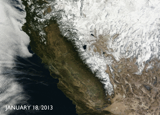
Although 2013 turned out to be one of California's driest years on record, it began, at least, with a relatively solid layer of snow cover in the mountains. 2014, on the other hand, has started out far less auspiciously, as these NASA satellite images make clear. On the heels of two years of below-normal precipitation in the state, this winter's warm, dry conditions with anemic snow accumulation have given way to bare mountains and brown landscapes. With snowpack this month between 10 and 30 percent of its normal level, January 2014 will likely go down as California's driest January on record.

NASA satellite image from Jan. 18, 2014.
NASA satellite image from Jan. 18, 2013.

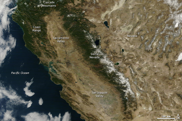
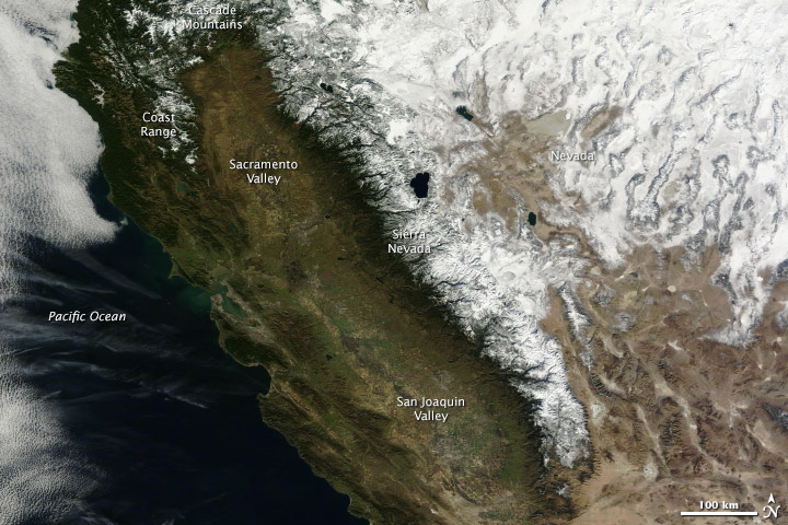
Captured from NASA’s Terra satellite and published on the agency's Earth Observatory site, the two images contrast conditions from January 18 of this year and last year. The photos speak for themselves: this year, the Sierra Nevada range has only a tiny fraction of the snow it had last year, and the Coast Range and Cascade Mountains are now pretty much dry to the bone.

Sponsored

NASA notes, however, that there is room for some optimism, as much of an entire year's snowpack can originate from just a few major weather events (as was the case in 2013). One or two major storms, which could still be in the cards for the remaining months this winter, would likely contribute heartily to the state's dwindling water supply.

The images also show a sharp, albeit more subtle, contrast in the condition of the vegetation west of the Sierra Nevada range. As the description on the site explains:

In 2013—a year into the drought—the central valley was green with growing crops. The coastal hills were also green from winter rain. In 2014, everything west of the forested mountains is brown. Even irrigated agriculture in the center of the state appears to be limited compared to 2013 ... Under such conditions, California may be prone to water shortages, crop loss and the loss of farm jobs, and increased wildfires, warned the emergency proclamation.

lower waypoint
next waypoint
Why So Many Central Americans Are Seeking Asylum in the U.S.Real-Time Interactive Earthquake Map: Get to Know Your Local FaultsIt's Really Happening! This Is What KQED's Youth Takeover Looks LikeWhen Rivers Caught Fire: A Brief History of Earth Day (with Lesson Plan)A Look Inside the Youth Vaping CrazeIt's Almost Tax Day. This Is How the Government Spends Your Hard-Earned CashIs the Endangered Species Act at Risk of Extinction?March Madness and the Money: Should College Athletes Get Paid?How to Stop a Nuclear War: The Non-Proliferation Treaty, ExplainedMAP: What Does the U.S.-Mexico Border Really Look Like?