upper waypoint

A Map of Everyone in America (and Canada)

Save ArticleSave Article
Failed to save article

Please try again

Brandon Martin-Anderson Public Domain
Brandon Martin-Anderson

Even if dorking out on maps isn't your idea of a good time, this one's definitely worth a look.

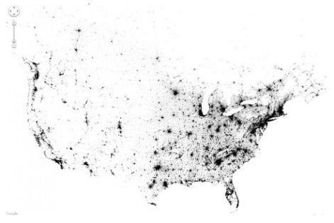
It's a dot map of every person counted by the 2010 US and 2011 Canadian censuses. 341,817,095 unique individuals, to be exact. And each person - every last man, woman, and child - is represented by a single point (click "show labels" at right to see location names as well).

It's like pointillism on steroids (take that, Seurat!).

The map is the handiwork of software engineer Brandon Martin-Anderson, who says he sought to produce "an image of human settlement patterns unmediated by proxies like city boundaries, arterial roads and state lines."

So what does this map tell us?

Sponsored

Well, for one it shows that the brunt of the nation's political power is centered in a handful of densely packed, physically small urban areas. If you think about concepts like the Electoral College and Congressional representation, this map clearly visualizes just how physically uneven the distribution of political influence is throughout the country.

A few other somewhat obvious observations:

1. The coasts: The East Coast is a good deal more densely populated than is the West (with the metropolitan Los Angeles area as the major exception). And compared to the coasts, the middle of the country is pretty darn sparse.

2. Roads:If you look closely, you'll find concentrated lines of population along major roadways (zoom in, for instance, to Interstate 80 in the the East Bay; Rt. 101 near LA; or I-95 from New York City to Washington DC).

3. Water: Population centers are generally concentrated along waterways - whether they be coastlines, bays, major rivers, or big lakes.

lower waypoint
next waypoint
Why So Many Central Americans Are Seeking Asylum in the U.S.Real-Time Interactive Earthquake Map: Get to Know Your Local FaultsIt's Really Happening! This Is What KQED's Youth Takeover Looks LikeWhen Rivers Caught Fire: A Brief History of Earth Day (with Lesson Plan)A Look Inside the Youth Vaping CrazeIt's Almost Tax Day. This Is How the Government Spends Your Hard-Earned CashIs the Endangered Species Act at Risk of Extinction?March Madness and the Money: Should College Athletes Get Paid?How to Stop a Nuclear War: The Non-Proliferation Treaty, ExplainedMAP: What Does the U.S.-Mexico Border Really Look Like?