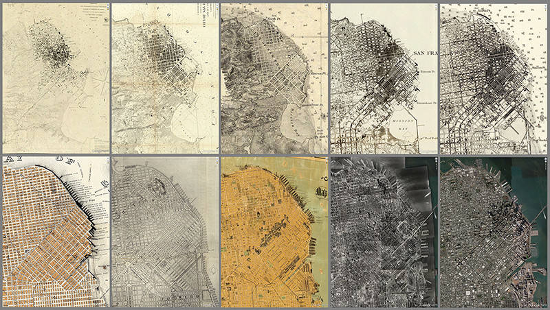
These maps of San Francisco show how the city grew from 1853 to 2015. They're of varying sizes and scales, but when digitized, they can be "geo-referenced" against Google Earth and then easily compared. (Photo: Courtesy of The David Rumsey Map Center)
One of the largest map collections in the country is about to open at Stanford. The David Rumsey Map Center is not just big in size, with more than 150,000 items, including rare first editions. It’s also accessible world-wide because many of the maps have been digitized; more than 67,000 items.
Retired real estate developer David Rumsey has been obsessed with maps since he was a small boy, and he’s been collecting for more than three decades. “I like modern maps, I like old maps,” Rumsey says. “I just find them fascinating. They’re art. They’re science. They’re history. All of those things.”
Rumsey has donated his entire collection to Stanford. It includes atlases, wall maps, globes, maritime charts, and even children’s maps made for school assignments. Highlights include a 19th century Jain cosmological diagram hand-painted on cloth, a leather-bound book considered to be the first true world atlas, Theatrum Orbis Terrarum(1570), and a map from the first published edition of Meriwether Lewis and William Clark’s Account of the Expedition.
A Map of Lewis and Clark’s Track, Across the Western Portion of North America From the Mississippi to the Pacific Ocean (1814). The map was copied by Samuel Lewis from William Clark’s original drawing, and was engraved by Samuel Harrison. (Photo: Courtesy of The David Rumsey Map Center)
Other map collections are represented at the center, including Glen McLaughlin’s California as an Island, which tells the story of a long-cherished misconception about California held by European map makers when the New World was still largely terra incognita to them.
Rumsey says he picked Stanford over other potential libraries because he didn’t want his maps locked away in dusty archives.“In the past, these kinds of collections were more about preservation, which is good, very admirable,” Rumsey says. “But we would like to change that paradigm.”
Sponsored
Digital revolution makes collections more accessible
A growing number of major map repositories have signed onto what’s known as the International Image Interoperability Framework. It’s a system that enables participating institutions to share their collections using compatible software to deliver high resolution images to anyone who asks. As a result of this development, curators everywhere can more easily put together exhibitions without having to physically bring artifacts to their museums. “It doesn’t matter where the actual image is,” says G. Salim Mohammed, the curator who heads the David Rumsey Map Center. “It could be in Europe. It could be in Africa. It could be anywhere there is Internet access.”
In addition to curators, the system stands to benefit scholars, school children, environmentalists, artists, and other groups.
“Maps in physical form are beautiful, but they’re hard to work with,” says Rumsey. “In digital form, they’re light as a feather.”
That Said, You Really Should Visit Stanford
So why go to Green Library, the physical building where the Center is located? For one thing, you’ll want to see the inaugural exhibition, A Universe of Maps in the Peterson Gallery on the library’s second floor. Massive printouts of the digitized maps from the collection are on the walls, including in the rotunda and in the stairwells. They’re even etched onto the glass doors at the entrance of the center. The sharpness of the detail is stunning. It may take you an hour to make your way into the center itself.
Once there, two floor-to-ceiling computer screens immediately capture your attention. One is a 12 x 7′ touch screen, for those big and small who’ve learned to relate to visual images through an iPad. The other screen is 16 x 9′. “These are basically screen savers that we commissioned from Stamen Design in San Francisco,” Rumsey jokes, just before he shows what you can do with them.
Plan de Turgota map of Paris (1739). This copy was printed from the original plates in approximately 1860. (Photo: Courtesy of The David Rumsey Map Center)
It’s not that you can’t zoom in and out, cross fade between maps, and do side-by-side comparisons on your laptop at home. But on a giant screen, you can zoom in to see incredible detail that often goes completely unnoticed when you’re looking at a map as a whole.
Rumsey pulls up Plan de Turgot, a map of Paris from 1739. “It’s 20 sheets in a book, but we knitted them altogether into one gigantic image,” Rumsey says. On Rumsey’s big screen, you can see a huge amount of detail. “You see all the piles of wood?” Rumsey says. “That’s the heating source for Paris in 1739.” Rumsey clicks around, to show how wood is making its way from outside the city to homes inside. “The man that made this map had permission from the king to go into all the back yards,” Rumsey says. “So he has the gardens. It’s just an extraordinary cultural record. Maps are just like books. They’re filled with all kinds of stories to tell.”
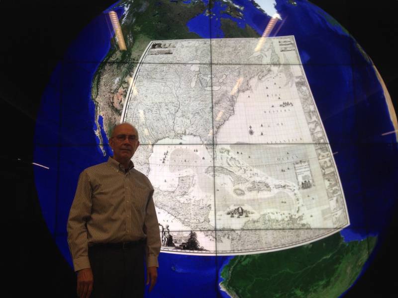
David Rumsey stands in front of a map from 1733 superimposed over Google Earth. Wouldn’t you like to run a search for viewing on a 16 x 9′ computer screen? (Photo: Rachael Myrow/KQED)
The David Rumsey Map Center opens for special events Tuesday, Apr. 19. It opens to the public Tuesday, Apr. 25. More info here.
lower waypoint
Care about what’s happening in Bay Area arts? Stay informed with one email every other week—right to your inbox.
window.__IS_SSR__=true
window.__INITIAL_STATE__={"attachmentsReducer":{"audio_0":{"type":"attachments","id":"audio_0","imgSizes":{"kqedFullSize":{"file":"https://ww2.kqed.org/news/wp-content/themes/KQED-unified/img/audio_bgs/background0.jpg"}}},"audio_1":{"type":"attachments","id":"audio_1","imgSizes":{"kqedFullSize":{"file":"https://ww2.kqed.org/news/wp-content/themes/KQED-unified/img/audio_bgs/background1.jpg"}}},"audio_2":{"type":"attachments","id":"audio_2","imgSizes":{"kqedFullSize":{"file":"https://ww2.kqed.org/news/wp-content/themes/KQED-unified/img/audio_bgs/background2.jpg"}}},"audio_3":{"type":"attachments","id":"audio_3","imgSizes":{"kqedFullSize":{"file":"https://ww2.kqed.org/news/wp-content/themes/KQED-unified/img/audio_bgs/background3.jpg"}}},"audio_4":{"type":"attachments","id":"audio_4","imgSizes":{"kqedFullSize":{"file":"https://ww2.kqed.org/news/wp-content/themes/KQED-unified/img/audio_bgs/background4.jpg"}}},"placeholder":{"type":"attachments","id":"placeholder","imgSizes":{"thumbnail":{"file":"https://ww2.kqed.org/wp-content/uploads/sites/10/2018/01/GettyImages-896326950-160x96.jpg","width":160,"height":96,"mimeType":"image/jpeg"},"medium":{"file":"https://ww2.kqed.org/wp-content/uploads/sites/10/2018/01/GettyImages-896326950-800x478.jpg","width":800,"height":478,"mimeType":"image/jpeg"},"large":{"file":"https://ww2.kqed.org/wp-content/uploads/sites/10/2018/01/GettyImages-896326950-1020x610.jpg","width":1020,"height":610,"mimeType":"image/jpeg"},"fd-lrg":{"file":"https://ww2.kqed.org/wp-content/uploads/sites/10/2018/01/GettyImages-896326950-1920x1148.jpg","width":1920,"height":1148,"mimeType":"image/jpeg"},"fd-med":{"file":"https://ww2.kqed.org/wp-content/uploads/sites/10/2018/01/GettyImages-896326950-1180x705.jpg","width":1180,"height":705,"mimeType":"image/jpeg"},"fd-sm":{"file":"https://ww2.kqed.org/wp-content/uploads/sites/10/2018/01/GettyImages-896326950-960x574.jpg","width":960,"height":574,"mimeType":"image/jpeg"},"post-thumbnail":{"file":"https://ww2.kqed.org/wp-content/uploads/sites/10/2018/01/GettyImages-896326950-672x372.jpg","width":672,"height":372,"mimeType":"image/jpeg"},"twentyfourteen-full-width":{"file":"https://ww2.kqed.org/wp-content/uploads/sites/10/2018/01/GettyImages-896326950-1038x576.jpg","width":1038,"height":576,"mimeType":"image/jpeg"},"xxsmall":{"file":"https://ww2.kqed.org/wp-content/uploads/sites/10/2018/01/GettyImages-896326950-240x143.jpg","width":240,"height":143,"mimeType":"image/jpeg"},"xsmall":{"file":"https://ww2.kqed.org/wp-content/uploads/sites/10/2018/01/GettyImages-896326950-375x224.jpg","width":375,"height":224,"mimeType":"image/jpeg"},"small":{"file":"https://ww2.kqed.org/wp-content/uploads/sites/10/2018/01/GettyImages-896326950-520x311.jpg","width":520,"height":311,"mimeType":"image/jpeg"},"xlarge":{"file":"https://ww2.kqed.org/wp-content/uploads/sites/10/2018/01/GettyImages-896326950-1180x705.jpg","width":1180,"height":705,"mimeType":"image/jpeg"},"full-width":{"file":"https://ww2.kqed.org/wp-content/uploads/sites/10/2018/01/GettyImages-896326950-1920x1148.jpg","width":1920,"height":1148,"mimeType":"image/jpeg"},"guest-author-32":{"file":"https://ww2.kqed.org/wp-content/uploads/sites/10/2018/01/GettyImages-896326950-32x32.jpg","width":32,"height":32,"mimeType":"image/jpeg"},"guest-author-50":{"file":"https://ww2.kqed.org/wp-content/uploads/sites/10/2018/01/GettyImages-896326950-50x50.jpg","width":50,"height":50,"mimeType":"image/jpeg"},"guest-author-64":{"file":"https://ww2.kqed.org/wp-content/uploads/sites/10/2018/01/GettyImages-896326950-64x64.jpg","width":64,"height":64,"mimeType":"image/jpeg"},"guest-author-96":{"file":"https://ww2.kqed.org/wp-content/uploads/sites/10/2018/01/GettyImages-896326950-96x96.jpg","width":96,"height":96,"mimeType":"image/jpeg"},"guest-author-128":{"file":"https://ww2.kqed.org/wp-content/uploads/sites/10/2018/01/GettyImages-896326950-128x128.jpg","width":128,"height":128,"mimeType":"image/jpeg"},"detail":{"file":"https://ww2.kqed.org/wp-content/uploads/sites/10/2018/01/GettyImages-896326950-150x150.jpg","width":150,"height":150,"mimeType":"image/jpeg"},"kqedFullSize":{"file":"https://ww2.kqed.org/wp-content/uploads/sites/10/2018/01/GettyImages-896326950-e1514998105161.jpg","width":1920,"height":1148}}},"arts_13955887":{"type":"attachments","id":"arts_13955887","meta":{"index":"attachments_1591205162","site":"arts","id":"13955887","found":true},"title":"apnimandi-crop","publishDate":1712883835,"status":"inherit","parent":13955884,"modified":1712883996,"caption":"Near midnight, all of the tables outside of Apni Mandi were occupied by diners feasting on chaat and curry. The Sunnyvale grocery store serves hot food 24 hours.","credit":"Thien Pham","altTag":"A spread of Indian food on an outdoor table, including a rice combination tray, two samosas, a mango lassi and a plate of dahi puri. A man puts one of the dahi puri in his mouth.","description":null,"imgSizes":{"medium":{"file":"https://cdn.kqed.org/wp-content/uploads/sites/2/2024/04/apnimandi-crop-800x450.jpg","width":800,"height":450,"mimeType":"image/jpeg"},"large":{"file":"https://cdn.kqed.org/wp-content/uploads/sites/2/2024/04/apnimandi-crop-1020x574.jpg","width":1020,"height":574,"mimeType":"image/jpeg"},"thumbnail":{"file":"https://cdn.kqed.org/wp-content/uploads/sites/2/2024/04/apnimandi-crop-160x90.jpg","width":160,"height":90,"mimeType":"image/jpeg"},"medium_large":{"file":"https://cdn.kqed.org/wp-content/uploads/sites/2/2024/04/apnimandi-crop-768x432.jpg","width":768,"height":432,"mimeType":"image/jpeg"},"1536x1536":{"file":"https://cdn.kqed.org/wp-content/uploads/sites/2/2024/04/apnimandi-crop-1536x864.jpg","width":1536,"height":864,"mimeType":"image/jpeg"},"post-thumbnail":{"file":"https://cdn.kqed.org/wp-content/uploads/sites/2/2024/04/apnimandi-crop-672x372.jpg","width":672,"height":372,"mimeType":"image/jpeg"},"twentyfourteen-full-width":{"file":"https://cdn.kqed.org/wp-content/uploads/sites/2/2024/04/apnimandi-crop-1038x576.jpg","width":1038,"height":576,"mimeType":"image/jpeg"},"kqedFullSize":{"file":"https://cdn.kqed.org/wp-content/uploads/sites/2/2024/04/apnimandi-crop.jpg","width":1920,"height":1080}},"fetchFailed":false,"isLoading":false},"arts_13955963":{"type":"attachments","id":"arts_13955963","meta":{"index":"attachments_1591205162","site":"arts","id":"13955963","found":true},"title":"Ben.Jerrys.IceCream.free","publishDate":1713198894,"status":"inherit","parent":13955953,"modified":1713198966,"caption":"Visitors can can a free ice cream in a cup or cone at Ben & Jerry's stores on Tuesday, April 16, 2024. ","credit":"Ben & Jerry's","altTag":"A woman's hand with pink painted nails holds two cones of ice cream in the air","description":null,"imgSizes":{"medium":{"file":"https://cdn.kqed.org/wp-content/uploads/sites/2/2024/04/Ben.Jerrys.IceCream.free_-800x450.jpg","width":800,"height":450,"mimeType":"image/jpeg"},"large":{"file":"https://cdn.kqed.org/wp-content/uploads/sites/2/2024/04/Ben.Jerrys.IceCream.free_-1020x574.jpg","width":1020,"height":574,"mimeType":"image/jpeg"},"thumbnail":{"file":"https://cdn.kqed.org/wp-content/uploads/sites/2/2024/04/Ben.Jerrys.IceCream.free_-160x90.jpg","width":160,"height":90,"mimeType":"image/jpeg"},"medium_large":{"file":"https://cdn.kqed.org/wp-content/uploads/sites/2/2024/04/Ben.Jerrys.IceCream.free_-768x432.jpg","width":768,"height":432,"mimeType":"image/jpeg"},"post-thumbnail":{"file":"https://cdn.kqed.org/wp-content/uploads/sites/2/2024/04/Ben.Jerrys.IceCream.free_-672x372.jpg","width":672,"height":372,"mimeType":"image/jpeg"},"twentyfourteen-full-width":{"file":"https://cdn.kqed.org/wp-content/uploads/sites/2/2024/04/Ben.Jerrys.IceCream.free_-1038x576.jpg","width":1038,"height":576,"mimeType":"image/jpeg"},"kqedFullSize":{"file":"https://cdn.kqed.org/wp-content/uploads/sites/2/2024/04/Ben.Jerrys.IceCream.free_.jpg","width":1500,"height":844}},"fetchFailed":false,"isLoading":false},"arts_13955596":{"type":"attachments","id":"arts_13955596","meta":{"index":"attachments_1591205162","site":"arts","id":"13955596","found":true},"title":"2024’s World Naked Bike Ride is happening on April 20.","publishDate":1712613716,"status":"inherit","parent":13955410,"modified":1712613815,"caption":"2024’s World Naked Bike Ride is happening on April 20.","credit":"James D. Morgan/ Getty Images","altTag":"A group of men and women in varying stages of nudity ride bikes together up a road.","description":null,"imgSizes":{"medium":{"file":"https://cdn.kqed.org/wp-content/uploads/sites/2/2024/04/GettyImages-1306954242-800x504.jpg","width":800,"height":504,"mimeType":"image/jpeg"},"large":{"file":"https://cdn.kqed.org/wp-content/uploads/sites/2/2024/04/GettyImages-1306954242-1020x643.jpg","width":1020,"height":643,"mimeType":"image/jpeg"},"thumbnail":{"file":"https://cdn.kqed.org/wp-content/uploads/sites/2/2024/04/GettyImages-1306954242-160x101.jpg","width":160,"height":101,"mimeType":"image/jpeg"},"medium_large":{"file":"https://cdn.kqed.org/wp-content/uploads/sites/2/2024/04/GettyImages-1306954242-768x484.jpg","width":768,"height":484,"mimeType":"image/jpeg"},"1536x1536":{"file":"https://cdn.kqed.org/wp-content/uploads/sites/2/2024/04/GettyImages-1306954242-1536x968.jpg","width":1536,"height":968,"mimeType":"image/jpeg"},"2048x2048":{"file":"https://cdn.kqed.org/wp-content/uploads/sites/2/2024/04/GettyImages-1306954242-2048x1291.jpg","width":2048,"height":1291,"mimeType":"image/jpeg"},"post-thumbnail":{"file":"https://cdn.kqed.org/wp-content/uploads/sites/2/2024/04/GettyImages-1306954242-672x372.jpg","width":672,"height":372,"mimeType":"image/jpeg"},"twentyfourteen-full-width":{"file":"https://cdn.kqed.org/wp-content/uploads/sites/2/2024/04/GettyImages-1306954242-1038x576.jpg","width":1038,"height":576,"mimeType":"image/jpeg"},"full-width":{"file":"https://cdn.kqed.org/wp-content/uploads/sites/2/2024/04/GettyImages-1306954242-1920x1210.jpg","width":1920,"height":1210,"mimeType":"image/jpeg"},"kqedFullSize":{"file":"https://cdn.kqed.org/wp-content/uploads/sites/2/2024/04/GettyImages-1306954242-scaled-e1712613746898.jpg","width":1920,"height":1211}},"fetchFailed":false,"isLoading":false},"arts_13956006":{"type":"attachments","id":"arts_13956006","meta":{"index":"attachments_1591205162","site":"arts","id":"13956006","found":true},"title":"CalvinKeys","publishDate":1713214640,"status":"inherit","parent":13955977,"modified":1713232970,"caption":"Oakland jazz guitarist Calvin Keys rose to global acclaim, playing with dozens of jazz giants and releasing numerous classic recordings.","credit":"Jim Denis","altTag":"A smiling Black man in a ballcap and greying beard, wearing a grey sweatshirt.","description":null,"imgSizes":{"medium":{"file":"https://cdn.kqed.org/wp-content/uploads/sites/2/2024/04/CalvinKeys-800x450.jpg","width":800,"height":450,"mimeType":"image/jpeg"},"large":{"file":"https://cdn.kqed.org/wp-content/uploads/sites/2/2024/04/CalvinKeys-1020x574.jpg","width":1020,"height":574,"mimeType":"image/jpeg"},"thumbnail":{"file":"https://cdn.kqed.org/wp-content/uploads/sites/2/2024/04/CalvinKeys-160x90.jpg","width":160,"height":90,"mimeType":"image/jpeg"},"medium_large":{"file":"https://cdn.kqed.org/wp-content/uploads/sites/2/2024/04/CalvinKeys-768x432.jpg","width":768,"height":432,"mimeType":"image/jpeg"},"post-thumbnail":{"file":"https://cdn.kqed.org/wp-content/uploads/sites/2/2024/04/CalvinKeys-672x372.jpg","width":672,"height":372,"mimeType":"image/jpeg"},"twentyfourteen-full-width":{"file":"https://cdn.kqed.org/wp-content/uploads/sites/2/2024/04/CalvinKeys-1038x576.jpg","width":1038,"height":576,"mimeType":"image/jpeg"},"kqedFullSize":{"file":"https://cdn.kqed.org/wp-content/uploads/sites/2/2024/04/CalvinKeys.jpg","width":1058,"height":595}},"fetchFailed":false,"isLoading":false},"arts_13955949":{"type":"attachments","id":"arts_13955949","meta":{"index":"attachments_1591205162","site":"arts","id":"13955949","found":true},"title":"From the Max documentary ‘Brandy Hellville & the Cult of Fast Fashion.’","publishDate":1713160661,"status":"inherit","parent":13955948,"modified":1713161531,"caption":"From the Max documentary ‘Brandy Hellville & the Cult of Fast Fashion.’","credit":"Max","altTag":"Two slender blonde young women stand in a field shaking their long hair in front of their faces.","description":null,"imgSizes":{"medium":{"file":"https://cdn.kqed.org/wp-content/uploads/sites/2/2024/04/brandy-hellville-the-cult-of-fast-fashion_1_custom-02fe7696d2aa7c8c1748614c017d2e87857d4da0-800x533.jpg","width":800,"height":533,"mimeType":"image/jpeg"},"large":{"file":"https://cdn.kqed.org/wp-content/uploads/sites/2/2024/04/brandy-hellville-the-cult-of-fast-fashion_1_custom-02fe7696d2aa7c8c1748614c017d2e87857d4da0-1020x679.jpg","width":1020,"height":679,"mimeType":"image/jpeg"},"thumbnail":{"file":"https://cdn.kqed.org/wp-content/uploads/sites/2/2024/04/brandy-hellville-the-cult-of-fast-fashion_1_custom-02fe7696d2aa7c8c1748614c017d2e87857d4da0-160x107.jpg","width":160,"height":107,"mimeType":"image/jpeg"},"medium_large":{"file":"https://cdn.kqed.org/wp-content/uploads/sites/2/2024/04/brandy-hellville-the-cult-of-fast-fashion_1_custom-02fe7696d2aa7c8c1748614c017d2e87857d4da0-768x511.jpg","width":768,"height":511,"mimeType":"image/jpeg"},"1536x1536":{"file":"https://cdn.kqed.org/wp-content/uploads/sites/2/2024/04/brandy-hellville-the-cult-of-fast-fashion_1_custom-02fe7696d2aa7c8c1748614c017d2e87857d4da0-1536x1022.jpg","width":1536,"height":1022,"mimeType":"image/jpeg"},"post-thumbnail":{"file":"https://cdn.kqed.org/wp-content/uploads/sites/2/2024/04/brandy-hellville-the-cult-of-fast-fashion_1_custom-02fe7696d2aa7c8c1748614c017d2e87857d4da0-672x372.jpg","width":672,"height":372,"mimeType":"image/jpeg"},"twentyfourteen-full-width":{"file":"https://cdn.kqed.org/wp-content/uploads/sites/2/2024/04/brandy-hellville-the-cult-of-fast-fashion_1_custom-02fe7696d2aa7c8c1748614c017d2e87857d4da0-1038x576.jpg","width":1038,"height":576,"mimeType":"image/jpeg"},"kqedFullSize":{"file":"https://cdn.kqed.org/wp-content/uploads/sites/2/2024/04/brandy-hellville-the-cult-of-fast-fashion_1_custom-02fe7696d2aa7c8c1748614c017d2e87857d4da0.jpg","width":1920,"height":1278}},"fetchFailed":false,"isLoading":false},"arts_13955501":{"type":"attachments","id":"arts_13955501","meta":{"index":"attachments_1591205162","site":"arts","id":"13955501","found":true},"title":"240404-JONATHANCARVERMOORE-034-BL-KQED","publishDate":1712271115,"status":"inherit","parent":0,"modified":1713291135,"caption":"Jonathan Carver Moore poses for a portrait at his eponymous gallery on Market Street in San Francisco on April 4, 2024. 'BOLD,' a solo show by artist Aplerh-Doku Borlabi, is on view behind him.","credit":"Beth LaBerge/KQED","altTag":"Black man stands with hands in pockets smiling in gallery space, two large paintings behind","description":null,"imgSizes":{"medium":{"file":"https://cdn.kqed.org/wp-content/uploads/sites/2/2024/04/240404-JONATHANCARVERMOORE-034-BL-KQED-800x533.jpg","width":800,"height":533,"mimeType":"image/jpeg"},"large":{"file":"https://cdn.kqed.org/wp-content/uploads/sites/2/2024/04/240404-JONATHANCARVERMOORE-034-BL-KQED-1020x680.jpg","width":1020,"height":680,"mimeType":"image/jpeg"},"thumbnail":{"file":"https://cdn.kqed.org/wp-content/uploads/sites/2/2024/04/240404-JONATHANCARVERMOORE-034-BL-KQED-160x107.jpg","width":160,"height":107,"mimeType":"image/jpeg"},"medium_large":{"file":"https://cdn.kqed.org/wp-content/uploads/sites/2/2024/04/240404-JONATHANCARVERMOORE-034-BL-KQED-768x512.jpg","width":768,"height":512,"mimeType":"image/jpeg"},"1536x1536":{"file":"https://cdn.kqed.org/wp-content/uploads/sites/2/2024/04/240404-JONATHANCARVERMOORE-034-BL-KQED-1536x1024.jpg","width":1536,"height":1024,"mimeType":"image/jpeg"},"post-thumbnail":{"file":"https://cdn.kqed.org/wp-content/uploads/sites/2/2024/04/240404-JONATHANCARVERMOORE-034-BL-KQED-672x372.jpg","width":672,"height":372,"mimeType":"image/jpeg"},"twentyfourteen-full-width":{"file":"https://cdn.kqed.org/wp-content/uploads/sites/2/2024/04/240404-JONATHANCARVERMOORE-034-BL-KQED-1038x576.jpg","width":1038,"height":576,"mimeType":"image/jpeg"},"full-width":{"file":"https://cdn.kqed.org/wp-content/uploads/sites/2/2024/04/240404-JONATHANCARVERMOORE-034-BL-KQED-1920x1280.jpg","width":1920,"height":1280,"mimeType":"image/jpeg"},"kqedFullSize":{"file":"https://cdn.kqed.org/wp-content/uploads/sites/2/2024/04/240404-JONATHANCARVERMOORE-034-BL-KQED.jpg","width":2000,"height":1333}},"fetchFailed":false,"isLoading":false},"arts_13956034":{"type":"attachments","id":"arts_13956034","meta":{"index":"attachments_1591205162","site":"arts","id":"13956034","found":true},"title":"A two-spot octopus, like the type an Oklahoma family brought home as a pet.","publishDate":1713252779,"status":"inherit","parent":13956032,"modified":1713252826,"caption":"A two-spot octopus, like the type an Oklahoma family brought home as a pet.","credit":"NPR/ Angelina Komatovich","altTag":null,"description":null,"imgSizes":{"medium":{"file":"https://cdn.kqed.org/wp-content/uploads/sites/2/2024/04/Screen-Shot-2024-04-16-at-12.31.50-AM-800x471.png","width":800,"height":471,"mimeType":"image/png"},"large":{"file":"https://cdn.kqed.org/wp-content/uploads/sites/2/2024/04/Screen-Shot-2024-04-16-at-12.31.50-AM-1020x600.png","width":1020,"height":600,"mimeType":"image/png"},"thumbnail":{"file":"https://cdn.kqed.org/wp-content/uploads/sites/2/2024/04/Screen-Shot-2024-04-16-at-12.31.50-AM-160x94.png","width":160,"height":94,"mimeType":"image/png"},"medium_large":{"file":"https://cdn.kqed.org/wp-content/uploads/sites/2/2024/04/Screen-Shot-2024-04-16-at-12.31.50-AM-768x452.png","width":768,"height":452,"mimeType":"image/png"},"1536x1536":{"file":"https://cdn.kqed.org/wp-content/uploads/sites/2/2024/04/Screen-Shot-2024-04-16-at-12.31.50-AM-1536x904.png","width":1536,"height":904,"mimeType":"image/png"},"post-thumbnail":{"file":"https://cdn.kqed.org/wp-content/uploads/sites/2/2024/04/Screen-Shot-2024-04-16-at-12.31.50-AM-672x372.png","width":672,"height":372,"mimeType":"image/png"},"twentyfourteen-full-width":{"file":"https://cdn.kqed.org/wp-content/uploads/sites/2/2024/04/Screen-Shot-2024-04-16-at-12.31.50-AM-1038x576.png","width":1038,"height":576,"mimeType":"image/png"},"kqedFullSize":{"file":"https://cdn.kqed.org/wp-content/uploads/sites/2/2024/04/Screen-Shot-2024-04-16-at-12.31.50-AM.png","width":1744,"height":1026}},"fetchFailed":false,"isLoading":false},"arts_13955665":{"type":"attachments","id":"arts_13955665","meta":{"index":"attachments_1591205162","site":"arts","id":"13955665","found":true},"title":"Deftones perform in Michigan in 2022. The Sacramento rockers play Golden Gate Park on Aug. 17, 2024.","publishDate":1712689472,"status":"inherit","parent":13955656,"modified":1712689673,"caption":"Deftones performing in Michigan in 2022. The Sacramento rockers play Golden Gate Park on Aug. 17, 2024.","credit":"Scott Legato/ Getty Images)","altTag":"A man screams into a microphone, while perched, hunched over, at the edge of a stage. Stage lights shine behind him.","description":null,"imgSizes":{"medium":{"file":"https://cdn.kqed.org/wp-content/uploads/sites/2/2024/04/GettyImages-1399111367-800x571.jpg","width":800,"height":571,"mimeType":"image/jpeg"},"large":{"file":"https://cdn.kqed.org/wp-content/uploads/sites/2/2024/04/GettyImages-1399111367-1020x729.jpg","width":1020,"height":729,"mimeType":"image/jpeg"},"thumbnail":{"file":"https://cdn.kqed.org/wp-content/uploads/sites/2/2024/04/GettyImages-1399111367-160x114.jpg","width":160,"height":114,"mimeType":"image/jpeg"},"medium_large":{"file":"https://cdn.kqed.org/wp-content/uploads/sites/2/2024/04/GettyImages-1399111367-768x549.jpg","width":768,"height":549,"mimeType":"image/jpeg"},"1536x1536":{"file":"https://cdn.kqed.org/wp-content/uploads/sites/2/2024/04/GettyImages-1399111367-1536x1097.jpg","width":1536,"height":1097,"mimeType":"image/jpeg"},"2048x2048":{"file":"https://cdn.kqed.org/wp-content/uploads/sites/2/2024/04/GettyImages-1399111367-2048x1463.jpg","width":2048,"height":1463,"mimeType":"image/jpeg"},"post-thumbnail":{"file":"https://cdn.kqed.org/wp-content/uploads/sites/2/2024/04/GettyImages-1399111367-672x372.jpg","width":672,"height":372,"mimeType":"image/jpeg"},"twentyfourteen-full-width":{"file":"https://cdn.kqed.org/wp-content/uploads/sites/2/2024/04/GettyImages-1399111367-1038x576.jpg","width":1038,"height":576,"mimeType":"image/jpeg"},"full-width":{"file":"https://cdn.kqed.org/wp-content/uploads/sites/2/2024/04/GettyImages-1399111367-1920x1371.jpg","width":1920,"height":1371,"mimeType":"image/jpeg"},"kqedFullSize":{"file":"https://cdn.kqed.org/wp-content/uploads/sites/2/2024/04/GettyImages-1399111367-scaled-e1712689643171.jpg","width":1920,"height":1371}},"fetchFailed":false,"isLoading":false},"arts_13955842":{"type":"attachments","id":"arts_13955842","meta":{"index":"attachments_1591205162","site":"arts","id":"13955842","found":true},"title":"maggie-rogers","publishDate":1712870063,"status":"inherit","parent":13955839,"modified":1712870107,"caption":"Maggie Rogers: Heroine of the People.","credit":"Artist Photo","altTag":"A woman in tousled hair and a white top looks at the camera, mouth slightly open","description":null,"imgSizes":{"medium":{"file":"https://cdn.kqed.org/wp-content/uploads/sites/2/2024/04/maggie-rogers-800x450.jpg","width":800,"height":450,"mimeType":"image/jpeg"},"large":{"file":"https://cdn.kqed.org/wp-content/uploads/sites/2/2024/04/maggie-rogers-1020x574.jpg","width":1020,"height":574,"mimeType":"image/jpeg"},"thumbnail":{"file":"https://cdn.kqed.org/wp-content/uploads/sites/2/2024/04/maggie-rogers-160x90.jpg","width":160,"height":90,"mimeType":"image/jpeg"},"medium_large":{"file":"https://cdn.kqed.org/wp-content/uploads/sites/2/2024/04/maggie-rogers-768x432.jpg","width":768,"height":432,"mimeType":"image/jpeg"},"post-thumbnail":{"file":"https://cdn.kqed.org/wp-content/uploads/sites/2/2024/04/maggie-rogers-672x372.jpg","width":672,"height":372,"mimeType":"image/jpeg"},"twentyfourteen-full-width":{"file":"https://cdn.kqed.org/wp-content/uploads/sites/2/2024/04/maggie-rogers-1038x576.jpg","width":1038,"height":576,"mimeType":"image/jpeg"},"kqedFullSize":{"file":"https://cdn.kqed.org/wp-content/uploads/sites/2/2024/04/maggie-rogers.jpg","width":1344,"height":756}},"fetchFailed":false,"isLoading":false},"arts_13955793":{"type":"attachments","id":"arts_13955793","meta":{"index":"attachments_1591205162","site":"arts","id":"13955793","found":true},"title":"Judee-Sill-August-1971-(Credit--Greenwich-Entertainment)_2000","publishDate":1712852235,"status":"inherit","parent":13955781,"modified":1712852313,"caption":"Judee Sill in August 1971.","credit":"Greenwich Entertainment","altTag":"Person with long hair and blue eyeshadow set against flowering bush","description":null,"imgSizes":{"medium":{"file":"https://cdn.kqed.org/wp-content/uploads/sites/2/2024/04/Judee-Sill-August-1971-Credit-Greenwich-Entertainment_2000-800x546.jpg","width":800,"height":546,"mimeType":"image/jpeg"},"large":{"file":"https://cdn.kqed.org/wp-content/uploads/sites/2/2024/04/Judee-Sill-August-1971-Credit-Greenwich-Entertainment_2000-1020x696.jpg","width":1020,"height":696,"mimeType":"image/jpeg"},"thumbnail":{"file":"https://cdn.kqed.org/wp-content/uploads/sites/2/2024/04/Judee-Sill-August-1971-Credit-Greenwich-Entertainment_2000-160x109.jpg","width":160,"height":109,"mimeType":"image/jpeg"},"medium_large":{"file":"https://cdn.kqed.org/wp-content/uploads/sites/2/2024/04/Judee-Sill-August-1971-Credit-Greenwich-Entertainment_2000-768x524.jpg","width":768,"height":524,"mimeType":"image/jpeg"},"1536x1536":{"file":"https://cdn.kqed.org/wp-content/uploads/sites/2/2024/04/Judee-Sill-August-1971-Credit-Greenwich-Entertainment_2000-1536x1048.jpg","width":1536,"height":1048,"mimeType":"image/jpeg"},"post-thumbnail":{"file":"https://cdn.kqed.org/wp-content/uploads/sites/2/2024/04/Judee-Sill-August-1971-Credit-Greenwich-Entertainment_2000-672x372.jpg","width":672,"height":372,"mimeType":"image/jpeg"},"twentyfourteen-full-width":{"file":"https://cdn.kqed.org/wp-content/uploads/sites/2/2024/04/Judee-Sill-August-1971-Credit-Greenwich-Entertainment_2000-1038x576.jpg","width":1038,"height":576,"mimeType":"image/jpeg"},"full-width":{"file":"https://cdn.kqed.org/wp-content/uploads/sites/2/2024/04/Judee-Sill-August-1971-Credit-Greenwich-Entertainment_2000-1920x1309.jpg","width":1920,"height":1309,"mimeType":"image/jpeg"},"kqedFullSize":{"file":"https://cdn.kqed.org/wp-content/uploads/sites/2/2024/04/Judee-Sill-August-1971-Credit-Greenwich-Entertainment_2000.jpg","width":2000,"height":1364}},"fetchFailed":false,"isLoading":false},"arts_11496991":{"type":"attachments","id":"arts_11496991","meta":{"index":"attachments_1591205162","site":"arts","id":"11496991","found":true},"title":"RS19165_Case15wallGIS_800px-qut","publishDate":1460752701,"status":"inherit","parent":11496747,"modified":1460752716,"caption":"These maps of San Francisco show how the city grew from 1853 to 2015. They're of varying sizes and scales, but when digitized, they can be \"geo-referenced\" against Google Earth and then easily compared.","credit":"Photo: Courtesy of The David Rumsey Map Center","description":"These maps of San Francisco show how the city grew from 1853 to 2015. They're of varying sizes and scales, but when digitized, they can be \"geo-referenced\" against Google Earth and then easily compared.","imgSizes":{"thumbnail":{"file":"https://ww2.kqed.org/app/uploads/sites/2/2016/04/RS19165_Case15wallGIS_800px-qut-400x226.jpg","width":400,"height":226,"mimeType":"image/jpeg"},"medium":{"file":"https://ww2.kqed.org/app/uploads/sites/2/2016/04/RS19165_Case15wallGIS_800px-qut-800x452.jpg","width":800,"height":452,"mimeType":"image/jpeg"},"medium_large":{"file":"https://ww2.kqed.org/app/uploads/sites/2/2016/04/RS19165_Case15wallGIS_800px-qut-768x434.jpg","width":768,"height":434,"mimeType":"image/jpeg"},"post-thumbnail":{"file":"https://ww2.kqed.org/app/uploads/sites/2/2016/04/RS19165_Case15wallGIS_800px-qut-672x372.jpg","width":672,"height":372,"mimeType":"image/jpeg"},"guest-author-32":{"file":"https://ww2.kqed.org/app/uploads/sites/2/2016/04/RS19165_Case15wallGIS_800px-qut-32x32.jpg","width":32,"height":32,"mimeType":"image/jpeg"},"guest-author-64":{"file":"https://ww2.kqed.org/app/uploads/sites/2/2016/04/RS19165_Case15wallGIS_800px-qut-64x64.jpg","width":64,"height":64,"mimeType":"image/jpeg"},"guest-author-96":{"file":"https://ww2.kqed.org/app/uploads/sites/2/2016/04/RS19165_Case15wallGIS_800px-qut-96x96.jpg","width":96,"height":96,"mimeType":"image/jpeg"},"guest-author-128":{"file":"https://ww2.kqed.org/app/uploads/sites/2/2016/04/RS19165_Case15wallGIS_800px-qut-128x128.jpg","width":128,"height":128,"mimeType":"image/jpeg"},"detail":{"file":"https://ww2.kqed.org/app/uploads/sites/2/2016/04/RS19165_Case15wallGIS_800px-qut-75x75.jpg","width":75,"height":75,"mimeType":"image/jpeg"},"kqedFullSize":{"file":"https://ww2.kqed.org/app/uploads/sites/2/2016/04/RS19165_Case15wallGIS_800px-qut.jpg","width":800,"height":452}},"fetchFailed":false,"isLoading":false}},"audioPlayerReducer":{"postId":"stream_live"},"authorsReducer":{"byline_arts_13955948":{"type":"authors","id":"byline_arts_13955948","meta":{"override":true},"slug":"byline_arts_13955948","name":"Linda Holmes","isLoading":false},"byline_arts_13955879":{"type":"authors","id":"byline_arts_13955879","meta":{"override":true},"slug":"byline_arts_13955879","name":"Emily Wilson","isLoading":false},"byline_arts_13956032":{"type":"authors","id":"byline_arts_13956032","meta":{"override":true},"slug":"byline_arts_13956032","name":"Anita Snow, Associated Press","isLoading":false},"shotchkiss":{"type":"authors","id":"61","meta":{"index":"authors_1591205172","id":"61","found":true},"name":"Sarah Hotchkiss","firstName":"Sarah","lastName":"Hotchkiss","slug":"shotchkiss","email":"shotchkiss@kqed.org","display_author_email":true,"staff_mastheads":["arts"],"title":"Senior Associate Editor","bio":"Sarah Hotchkiss is a San Francisco \u003ca href=\"http://www.sarahhotchkiss.com\">artist\u003c/a> and arts writer. In 2019, she received the Dorothea & Leo Rabkin Foundation grant for visual art journalism and in 2020 she received a Society of Professional Journalists, Northern California award for excellence in arts and culture reporting.","avatar":"https://secure.gravatar.com/avatar/ca38c7f54590856cd4947d26274f8a90?s=600&d=blank&r=g","twitter":"sahotchkiss","facebook":null,"instagram":null,"linkedin":null,"sites":[{"site":"","roles":["editor"]},{"site":"arts","roles":["Contributor","administrator"]},{"site":"artschool","roles":["administrator"]},{"site":"news","roles":["editor"]},{"site":"pop","roles":["administrator"]},{"site":"bayareabites","roles":["editor"]},{"site":"spark","roles":["editor"]},{"site":"checkplease","roles":["editor"]}],"headData":{"title":"Sarah Hotchkiss | KQED","description":"Senior Associate Editor","ogImgSrc":"https://secure.gravatar.com/avatar/ca38c7f54590856cd4947d26274f8a90?s=600&d=blank&r=g","twImgSrc":"https://secure.gravatar.com/avatar/ca38c7f54590856cd4947d26274f8a90?s=600&d=blank&r=g"},"isLoading":false,"link":"/author/shotchkiss"},"gmeline":{"type":"authors","id":"185","meta":{"index":"authors_1591205172","id":"185","found":true},"name":"Gabe Meline","firstName":"Gabe","lastName":"Meline","slug":"gmeline","email":"gmeline@kqed.org","display_author_email":false,"staff_mastheads":["arts"],"title":"Senior Editor, KQED Arts & Culture","bio":"Gabe Meline entered journalism at age 15 making photocopied zines, and has since earned awards from the Edward R. Murrow Awards, the Society for Professional Journalists, the Online Journalism Awards, the Association of Alternative Newsweeklies and the California Newspaper Publishers Association. Prior to KQED, he was the editor of the \u003cem>North Bay Bohemian\u003c/em> and a touring musician. He lives with his wife, his daughter, and a 1964 Volvo in his hometown of Santa Rosa, CA.","avatar":"https://secure.gravatar.com/avatar/80e9715844c5fc3f07edac5b08973b76?s=600&d=blank&r=g","twitter":"gmeline","facebook":null,"instagram":null,"linkedin":null,"sites":[{"site":"","roles":["editor"]},{"site":"arts","roles":["administrator"]},{"site":"artschool","roles":["editor"]},{"site":"news","roles":["author"]},{"site":"pop","roles":["editor"]},{"site":"bayareabites","roles":["editor"]},{"site":"food","roles":["editor"]},{"site":"liveblog","roles":["editor"]},{"site":"hiphop","roles":["editor"]}],"headData":{"title":"Gabe Meline | KQED","description":"Senior Editor, KQED Arts & Culture","ogImgSrc":"https://secure.gravatar.com/avatar/80e9715844c5fc3f07edac5b08973b76?s=600&d=blank&r=g","twImgSrc":"https://secure.gravatar.com/avatar/80e9715844c5fc3f07edac5b08973b76?s=600&d=blank&r=g"},"isLoading":false,"link":"/author/gmeline"},"ralexandra":{"type":"authors","id":"11242","meta":{"index":"authors_1591205172","id":"11242","found":true},"name":"Rae Alexandra","firstName":"Rae","lastName":"Alexandra","slug":"ralexandra","email":"ralexandra@kqed.org","display_author_email":false,"staff_mastheads":["arts"],"title":"Staff Writer","bio":"Rae Alexandra is Staff Writer for KQED Arts & Culture, and the creator/author of the \u003ca href=\"https://www.kqed.org/arts/program/rebel-girls-from-bay-area-history\">Rebel Girls From Bay Area History\u003c/a> and \u003ca href=\"https://www.kqed.org/bizarrebayarea\">Bizarre Bay Area\u003c/a> series. Born and raised in Wales, she started her career in London, as a music journalist for uproarious rock ’n’ roll magazine, \u003cem>\u003ca href=\"https://www.kerrang.com/features/an-oral-history-of-alternative-tentacles-40-years-of-keeping-punk-alive/\">Kerrang!\u003c/a>\u003c/em>. In America, she got her start at alt-weeklies including \u003ca href=\"https://archives.sfweekly.com/sanfrancisco/ArticleArchives?author=2127078&excludeCategoryType=Blog\">\u003cem>SF Weekly\u003c/em>\u003c/a> and the \u003ca href=\"https://www.villagevoice.com/author/raealexandra/\">\u003cem>Village Voice\u003c/em>\u003c/a>, and freelanced for a great many other publications. Her undying love for San Francisco has, more recently, turned her into \u003ca href=\"https://www.kqed.org/arts/tag/bayareahistory/\">a history nerd\u003c/a>. In 2023, Rae was awarded an SPJ Excellence in Journalism Award for Arts & Culture.","avatar":"https://secure.gravatar.com/avatar/d5ef3d663d9adae1345d06932a3951de?s=600&d=blank&r=g","twitter":"raemondjjjj","facebook":null,"instagram":null,"linkedin":null,"sites":[{"site":"arts","roles":["editor"]},{"site":"news","roles":["editor"]},{"site":"pop","roles":["editor"]},{"site":"bayareabites","roles":["editor"]},{"site":"science","roles":["editor"]}],"headData":{"title":"Rae Alexandra | KQED","description":"Staff Writer","ogImgSrc":"https://secure.gravatar.com/avatar/d5ef3d663d9adae1345d06932a3951de?s=600&d=blank&r=g","twImgSrc":"https://secure.gravatar.com/avatar/d5ef3d663d9adae1345d06932a3951de?s=600&d=blank&r=g"},"isLoading":false,"link":"/author/ralexandra"},"ltsai":{"type":"authors","id":"11743","meta":{"index":"authors_1591205172","id":"11743","found":true},"name":"Luke Tsai","firstName":"Luke","lastName":"Tsai","slug":"ltsai","email":"ltsai@kqed.org","display_author_email":true,"staff_mastheads":["arts"],"title":"Food Editor","bio":"Luke Tsai is KQED's food editor and resident stinky tofu connoisseur. Prior to KQED, he was an editor at Eater SF, \u003cem>San Francisco \u003c/em>magazine, and the \u003cem>East Bay Express\u003c/em>, and his work has also appeared in TASTE, the \u003cem>San Francisco Chronicle\u003c/em>, and the \u003cem>Best Food Writing\u003c/em> anthology. When he isn't writing or editing, you'll find him eating most everything he can get his hands on.","avatar":"https://secure.gravatar.com/avatar/d1ff591a3047b143a0e23cf7f28fcac0?s=600&d=blank&r=g","twitter":"theluketsai","facebook":null,"instagram":null,"linkedin":null,"sites":[{"site":"","roles":["editor"]},{"site":"arts","roles":["administrator"]},{"site":"bayareabites","roles":["editor"]},{"site":"food","roles":["editor"]}],"headData":{"title":"Luke Tsai | KQED","description":"Food Editor","ogImgSrc":"https://secure.gravatar.com/avatar/d1ff591a3047b143a0e23cf7f28fcac0?s=600&d=blank&r=g","twImgSrc":"https://secure.gravatar.com/avatar/d1ff591a3047b143a0e23cf7f28fcac0?s=600&d=blank&r=g"},"isLoading":false,"link":"/author/ltsai"},"tpham":{"type":"authors","id":"11753","meta":{"index":"authors_1591205172","id":"11753","found":true},"name":"Thien Pham","firstName":"Thien","lastName":"Pham","slug":"tpham","email":"thiendog@gmail.com","display_author_email":false,"staff_mastheads":[],"title":"KQED Contributor","bio":null,"avatar":"https://secure.gravatar.com/avatar/fa68ed7d6a785e5294a7bb79a3f409c3?s=600&d=blank&r=g","twitter":null,"facebook":null,"instagram":null,"linkedin":null,"sites":[{"site":"arts","roles":["contributor"]}],"headData":{"title":"Thien Pham | KQED","description":"KQED Contributor","ogImgSrc":"https://secure.gravatar.com/avatar/fa68ed7d6a785e5294a7bb79a3f409c3?s=600&d=blank&r=g","twImgSrc":"https://secure.gravatar.com/avatar/fa68ed7d6a785e5294a7bb79a3f409c3?s=600&d=blank&r=g"},"isLoading":false,"link":"/author/tpham"},"rachael-myrow":{"type":"authors","id":"251","meta":{"index":"authors_1591205172","id":"251","found":true},"name":"Rachael Myrow","firstName":"Rachael","lastName":"Myrow","slug":"rachael-myrow","email":"rmyrow@kqed.org","display_author_email":false,"staff_mastheads":["news"],"title":"Senior Editor of KQED's Silicon Valley News Desk","bio":"Rachael Myrow is Senior Editor of KQED's Silicon Valley News Desk. You can hear her work on \u003ca href=\"https://www.npr.org/search?query=Rachael%20Myrow&page=1\">NPR\u003c/a>, \u003ca href=\"https://theworld.org/people/rachael-myrow\">The World\u003c/a>, WBUR's \u003ca href=\"https://www.wbur.org/search?q=Rachael%20Myrow\">\u003ci>Here & Now\u003c/i>\u003c/a> and the BBC. \u003c/i>She also guest hosts for KQED's \u003ci>\u003ca href=\"https://www.kqed.org/forum/tag/rachael-myrow\">Forum\u003c/a>\u003c/i>. Over the years, she's talked with Kamau Bell, David Byrne, Kamala Harris, Tony Kushner, Armistead Maupin, Van Dyke Parks, Arnold Schwarzenegger and Tommie Smith, among others.\r\n\r\nBefore all this, she hosted \u003cem>The California Report\u003c/em> for 7+ years, reporting on topics like \u003ca href=\"https://soundcloud.com/rmyrow/on-a-mission-to-reform-assisted-living\">assisted living facilities\u003c/a>, the \u003ca href=\"https://www.npr.org/sections/alltechconsidered/2014/12/01/367703789/amazon-unleashes-robot-army-to-send-your-holiday-packages-faster\">robot takeover\u003c/a> of Amazon, and \u003ca href=\"https://www.kqed.org/bayareabites/50822/in-search-of-the-chocolate-persimmon\" rel=\"noopener noreferrer\">chocolate persimmons\u003c/a>.\r\n\r\nAwards? Sure: Peabody, Edward R. Murrow, Regional Edward R. Murrow, RTNDA, Northern California RTNDA, SPJ Northern California Chapter, LA Press Club, Golden Mic. Prior to joining KQED, Rachael worked in Los Angeles at KPCC and Marketplace. She holds degrees in English and journalism from UC Berkeley (where she got her start in public radio on KALX-FM).\r\n\r\nOutside of the studio, you'll find Rachael hiking Bay Area trails and whipping up Instagram-ready meals in her kitchen.","avatar":"https://secure.gravatar.com/avatar/87bf8cb5874e045cdff430523a6d48b1?s=600&d=blank&r=g","twitter":"rachaelmyrow","facebook":null,"instagram":null,"linkedin":"https://www.linkedin.com/in/rachaelmyrow/","sites":[{"site":"arts","roles":["administrator"]},{"site":"news","roles":["edit_others_posts","editor"]},{"site":"futureofyou","roles":["editor"]},{"site":"bayareabites","roles":["editor"]},{"site":"stateofhealth","roles":["editor"]},{"site":"science","roles":["editor"]},{"site":"food","roles":["editor"]},{"site":"forum","roles":["editor"]}],"headData":{"title":"Rachael Myrow | KQED","description":"Senior Editor of KQED's Silicon Valley News Desk","ogImgSrc":"https://secure.gravatar.com/avatar/87bf8cb5874e045cdff430523a6d48b1?s=600&d=blank&r=g","twImgSrc":"https://secure.gravatar.com/avatar/87bf8cb5874e045cdff430523a6d48b1?s=600&d=blank&r=g"},"isLoading":false,"link":"/author/rachael-myrow"}},"breakingNewsReducer":{},"campaignFinanceReducer":{},"firebase":{"requesting":{},"requested":{},"timestamps":{},"data":{},"ordered":{},"auth":{"isLoaded":false,"isEmpty":true},"authError":null,"profile":{"isLoaded":false,"isEmpty":true},"listeners":{"byId":{},"allIds":[]},"isInitializing":false,"errors":[]},"navBarReducer":{"navBarId":"arts","fullView":true,"showPlayer":false},"navMenuReducer":{"menus":[{"key":"menu1","items":[{"name":"News","link":"/","type":"title"},{"name":"Politics","link":"/politics"},{"name":"Science","link":"/science"},{"name":"Education","link":"/educationnews"},{"name":"Housing","link":"/housing"},{"name":"Immigration","link":"/immigration"},{"name":"Criminal Justice","link":"/criminaljustice"},{"name":"Silicon Valley","link":"/siliconvalley"},{"name":"Forum","link":"/forum"},{"name":"The California Report","link":"/californiareport"}]},{"key":"menu2","items":[{"name":"Arts & Culture","link":"/arts","type":"title"},{"name":"Critics’ Picks","link":"/thedolist"},{"name":"Cultural Commentary","link":"/artscommentary"},{"name":"Food & Drink","link":"/food"},{"name":"Bay Area Hip-Hop","link":"/bayareahiphop"},{"name":"Rebel Girls","link":"/rebelgirls"},{"name":"Arts Video","link":"/artsvideos"}]},{"key":"menu3","items":[{"name":"Podcasts","link":"/podcasts","type":"title"},{"name":"Bay Curious","link":"/podcasts/baycurious"},{"name":"Rightnowish","link":"/podcasts/rightnowish"},{"name":"The Bay","link":"/podcasts/thebay"},{"name":"On Our Watch","link":"/podcasts/onourwatch"},{"name":"Mindshift","link":"/podcasts/mindshift"},{"name":"Consider This","link":"/podcasts/considerthis"},{"name":"Political Breakdown","link":"/podcasts/politicalbreakdown"}]},{"key":"menu4","items":[{"name":"Live Radio","link":"/radio","type":"title"},{"name":"TV","link":"/tv","type":"title"},{"name":"Events","link":"/events","type":"title"},{"name":"For Educators","link":"/education","type":"title"},{"name":"Support KQED","link":"/support","type":"title"},{"name":"About","link":"/about","type":"title"},{"name":"Help Center","link":"https://kqed-helpcenter.kqed.org/s","type":"title"}]}]},"pagesReducer":{},"postsReducer":{"stream_live":{"type":"live","id":"stream_live","audioUrl":"https://streams.kqed.org/kqedradio","title":"Live Stream","excerpt":"Live Stream information currently unavailable.","link":"/radio","featImg":"","label":{"name":"KQED Live","link":"/"}},"stream_kqedNewscast":{"type":"posts","id":"stream_kqedNewscast","audioUrl":"https://www.kqed.org/.stream/anon/radio/RDnews/newscast.mp3?_=1","title":"KQED Newscast","featImg":"","label":{"name":"88.5 FM","link":"/"}},"arts_13955884":{"type":"posts","id":"arts_13955884","meta":{"index":"posts_1591205157","site":"arts","id":"13955884","found":true},"guestAuthors":[],"slug":"sunnyvale-late-night-food-24-hour-indian-grocery-apni-mandi-apna-bazar","title":"Sunnyvale’s Hottest Late-Night Food Spot Is the 24-Hour Indian Grocery Store","publishDate":1712884798,"format":"aside","headTitle":"Sunnyvale’s Hottest Late-Night Food Spot Is the 24-Hour Indian Grocery Store | KQED","labelTerm":{},"content":"\u003cfigure id=\"attachment_13955888\" class=\"wp-caption alignnone\" style=\"max-width: 1920px\">\u003cimg loading=\"lazy\" decoding=\"async\" class=\"size-full wp-image-13955888\" src=\"https://cdn.kqed.org/wp-content/uploads/sites/2/2024/04/apnimandi.jpg\" alt=\"A spread of Indian food on an outdoor table, including a rice combination tray, two samosas, a mango lassi and a plate of dahi puri. A man puts one of the dahi puri in his mouth.\" width=\"1920\" height=\"1920\" srcset=\"https://cdn.kqed.org/wp-content/uploads/sites/2/2024/04/apnimandi.jpg 1920w, https://cdn.kqed.org/wp-content/uploads/sites/2/2024/04/apnimandi-800x800.jpg 800w, https://cdn.kqed.org/wp-content/uploads/sites/2/2024/04/apnimandi-1020x1020.jpg 1020w, https://cdn.kqed.org/wp-content/uploads/sites/2/2024/04/apnimandi-160x160.jpg 160w, https://cdn.kqed.org/wp-content/uploads/sites/2/2024/04/apnimandi-768x768.jpg 768w, https://cdn.kqed.org/wp-content/uploads/sites/2/2024/04/apnimandi-1536x1536.jpg 1536w\" sizes=\"(max-width: 1920px) 100vw, 1920px\">\u003cfigcaption class=\"wp-caption-text\">Near midnight, all of the tables outside of Apni Mandi were occupied by diners feasting on chaat and curry. The Sunnyvale grocery store serves hot food 24 hours. \u003ccite>(Thien Pham)\u003c/cite>\u003c/figcaption>\u003c/figure>\n\u003cp>\u003ca href=\"https://www.kqed.org/arts/tag/the-midnight-diners\">\u003ci>The Midnight Diners\u003c/i>\u003c/a>\u003ci> is a regular collaboration between KQED food editor Luke Tsai and artist Thien Pham. Follow them each week as they explore the hot pot restaurants, taco carts and 24-hour casino buffets that make up the Bay Area’s after-hours dining scene.\u003c/i>\u003c/p>\n\u003cp>One of my personal oddities is that I love going to the grocery store late at night, strolling the fluorescent-lit aisles of my local Safeway a few minutes before closing, when the place resembles a ghost town. There is a sort of Zen-like quietude, I find, to being the only person in the freezer aisle picking out a tub of ice cream, or contemplating the 17 different varieties of instant noodles. In these days of still-mostly-remote work, sometimes it’s the only time I leave the house all day.\u003c/p>\n\u003cp>Not that any of this could have prepared me for the mind-boggling crowd of produce browsers, chai drinkers and late-night snackers; the heaps of bagged spices and upbeat Bhangra music; and, all together, the glorious chaos of an Indian grocery store at midnight. Specifically, the 24-hour \u003ca href=\"https://apnabazar.com/\">Apni Mandi\u003c/a> (formerly \u003ca href=\"https://www.instagram.com/sunnyvale_adda/\">Apna Bazar\u003c/a>) supermarket in Sunnyvale.\u003c/p>\n\u003cp>Of course, it was news to us that there even \u003ci>is \u003c/i>a 24-hour Indian grocery store in the Bay Area, much less one that sells hot vegetarian curries and chaat at all hours of the night. But even knowing that the place existed in theory, we were amazed to see just how many people — all ages, almost exclusively South Asian — had come to the grocery store past 11 o’clock at night. Outside, the eight or nine umbrella-topped tables in front of the store were all occupied by groups of friends making happy conversation over spreads of roti, curry platters and pani puri, devouring the food in the half-darkness. The only light came from the big, neon-yellow “Apni Mandi” sign glowing overhead.\u003c/p>\n\u003cp>Inside, the aisles were jam-packed with shoppers loading their carts with various sundries — a bag of onions, a bunch of half-ripe bananas, some Maggi noodles. More than a few just stood there chatting with a cup of (quite tasty) hot chai in hand, poured from the free chai dispenser at one end of the store. Others stood in line at a kiosk dedicated to selling assorted Indian cakes and sweets.\u003c/p>\n\u003cp>[ad fullwidth]\u003c/p>\n\u003cp>If my typical late-night grocery jaunts are more of a soothing, slightly antisocial balm, this felt electric — reminiscent of my favorite night markets in Asia.\u003c/p>\n\u003cfigure id=\"attachment_13955889\" class=\"wp-caption alignnone\" style=\"max-width: 1920px\">\u003cimg loading=\"lazy\" decoding=\"async\" class=\"size-full wp-image-13955889\" src=\"https://cdn.kqed.org/wp-content/uploads/sites/2/2024/04/apnimandi-inside.jpg\" alt=\"A crowd of people waiting in line to order food inside an Indian grocery store. \" width=\"1920\" height=\"1920\" srcset=\"https://cdn.kqed.org/wp-content/uploads/sites/2/2024/04/apnimandi-inside.jpg 1920w, https://cdn.kqed.org/wp-content/uploads/sites/2/2024/04/apnimandi-inside-800x800.jpg 800w, https://cdn.kqed.org/wp-content/uploads/sites/2/2024/04/apnimandi-inside-1020x1020.jpg 1020w, https://cdn.kqed.org/wp-content/uploads/sites/2/2024/04/apnimandi-inside-160x160.jpg 160w, https://cdn.kqed.org/wp-content/uploads/sites/2/2024/04/apnimandi-inside-768x768.jpg 768w, https://cdn.kqed.org/wp-content/uploads/sites/2/2024/04/apnimandi-inside-1536x1536.jpg 1536w\" sizes=\"(max-width: 1920px) 100vw, 1920px\">\u003cfigcaption class=\"wp-caption-text\">The longest line is at the hot food kiosk, where customers can choose from a variety of chaat, flatbreads and vegetarian curries. \u003ccite>(Thien Pham)\u003c/cite>\u003c/figcaption>\u003c/figure>\n\u003cp>By far the longest of the lines was the one for hot food. For 24 hours a day, customers can choose from an assortment of chaat, flatbreads and vegetarian curries, a \u003ca href=\"https://www.yelp.com/biz_photos/apna-bazar-sunnyvale?select=3570jvAKSEfKa0hWChZlHg\">rotating selection\u003c/a> of which are displayed in Apni Mandi’s steam table setup. There is, I’ll admit, a certain intimidation factor to ordering here if you’re a first-timer not fluent in the vocabulary of kulchas and bhaturas. When you get to the front of the line, none of the curries are labeled, nor is it obvious what anything on the chaat menu even \u003ci>is\u003c/i> if you haven’t had it before, and the long line behind you might add to the pressure.\u003c/p>\n\u003cp>But look: My feeling is that it’s healthy and character-building for every American to experience this mild level of discomfort at least once in a while — and when it’s in the service of procuring delicious food, who can complain? For the record, Apni Mandi’s friendly employees were happy to answer our questions, and, in a pinch, the smile-and-point method works perfectly well.\u003c/p>\n\u003cp>\u003cspan style=\"color: #2b2b2b;font-weight: 400\">\u003cb>\u003cstrong>\u003cspan style=\"font-weight: 400\">[aside postID='arts_13954983,arts_13954112,arts_13954597']\u003c/span>\u003c/strong>\u003c/b>\u003c/span>For just $8.99, the thali platter comes with rice, onions, roti and your choice of two of the day’s curries. The kadhi pakora was savory and tangy, with bits of vegetable fritter that had soaked in the sauce until they were pleasantly soggy. On the other end of the flavor spectrum, the paneer makhani was a chunky tomato-based curry with a wonderful zip of heat. Lunch, dinner, 3 a.m. snack, it doesn’t matter: This thali would make a fantastic meal at any time of day.\u003c/p>\n\u003cp>But really, everything we wound up ordering was delicious (and absurdly reasonable in price). The market’s hallmarks include its fresh, fat samosas, which come two to an order, with an aggressively well-spiced potato filling — the perfect thing to help you sort yourself out if you’ve had a little too much to drink. And the dahi puri are simply a delight: Close cousins to the better-known pani puri, the crispy semolina shells are topped with spices, tamarind chutney, yogurt and little crispy noodles. Try fitting the whole thing in your mouth at once for the ideal tangy-spicy-sweet bite.\u003c/p>\n\u003cp>With apologies, then, to my local Safeway, let us give praise to the 24-hour Indian grocer — to the pleasures of the hot food stand and the prospect of leaving home at midnight for the express purpose of sipping hot chai with friends in the produce aisle. Now that I’ve experienced it in all its glory, I’m afraid there’s no turning back.\u003c/p>\n\u003chr>\n\u003cp>\u003c/p>\n\u003cp>\u003ca href=\"https://www.instagram.com/sunnyvale_adda/\">\u003ci>Apni Mandi\u003c/i>\u003c/a>\u003ci> is open 24/7 at 1111 W. El Camino Real Ste. 107 in Sunnyvale.\u003c/i>\u003c/p>\n\n","blocks":[],"excerpt":"In the South Bay, Apni Mandi is the place to be for delicious midnight chaat, thalis and chai.","status":"publish","parent":0,"modified":1712956118,"stats":{"hasAudio":false,"hasVideo":false,"hasChartOrMap":false,"iframeSrcs":[],"hasGoogleForm":false,"hasGallery":false,"hasHearkenModule":false,"hasPolis":false,"paragraphCount":14,"wordCount":965},"headData":{"title":"Sunnyvale’s Best Late-Night Food Is at the 24-Hour Indian Grocery Store | KQED","description":"In the South Bay, Apni Mandi is the place to be for delicious midnight chaat, thalis and chai.","ogTitle":"Sunnyvale’s Hottest Late-Night Food Spot Is the 24-Hour Indian Grocery Store","ogDescription":"","ogImgId":"","twTitle":"Sunnyvale’s Hottest Late-Night Food Spot Is the 24-Hour Indian Grocery Store","twDescription":"","twImgId":"","socialTitle":"Sunnyvale’s Best Late-Night Food Is at the 24-Hour Indian Grocery Store %%page%% %%sep%% KQED"},"source":"The Midnight Diners","sourceUrl":"https://www.kqed.org/arts/tag/the-midnight-diners","sticky":false,"excludeFromSiteSearch":"Include","articleAge":"0","path":"/arts/13955884/sunnyvale-late-night-food-24-hour-indian-grocery-apni-mandi-apna-bazar","audioTrackLength":null,"parsedContent":[{"type":"contentString","content":"\u003cdiv class=\"post-body\">\u003cp>\u003cfigure id=\"attachment_13955888\" class=\"wp-caption alignnone\" style=\"max-width: 1920px\">\u003cimg loading=\"lazy\" decoding=\"async\" class=\"size-full wp-image-13955888\" src=\"https://cdn.kqed.org/wp-content/uploads/sites/2/2024/04/apnimandi.jpg\" alt=\"A spread of Indian food on an outdoor table, including a rice combination tray, two samosas, a mango lassi and a plate of dahi puri. A man puts one of the dahi puri in his mouth.\" width=\"1920\" height=\"1920\" srcset=\"https://cdn.kqed.org/wp-content/uploads/sites/2/2024/04/apnimandi.jpg 1920w, https://cdn.kqed.org/wp-content/uploads/sites/2/2024/04/apnimandi-800x800.jpg 800w, https://cdn.kqed.org/wp-content/uploads/sites/2/2024/04/apnimandi-1020x1020.jpg 1020w, https://cdn.kqed.org/wp-content/uploads/sites/2/2024/04/apnimandi-160x160.jpg 160w, https://cdn.kqed.org/wp-content/uploads/sites/2/2024/04/apnimandi-768x768.jpg 768w, https://cdn.kqed.org/wp-content/uploads/sites/2/2024/04/apnimandi-1536x1536.jpg 1536w\" sizes=\"(max-width: 1920px) 100vw, 1920px\">\u003cfigcaption class=\"wp-caption-text\">Near midnight, all of the tables outside of Apni Mandi were occupied by diners feasting on chaat and curry. The Sunnyvale grocery store serves hot food 24 hours. \u003ccite>(Thien Pham)\u003c/cite>\u003c/figcaption>\u003c/figure>\n\u003cp>\u003ca href=\"https://www.kqed.org/arts/tag/the-midnight-diners\">\u003ci>The Midnight Diners\u003c/i>\u003c/a>\u003ci> is a regular collaboration between KQED food editor Luke Tsai and artist Thien Pham. Follow them each week as they explore the hot pot restaurants, taco carts and 24-hour casino buffets that make up the Bay Area’s after-hours dining scene.\u003c/i>\u003c/p>\n\u003cp>One of my personal oddities is that I love going to the grocery store late at night, strolling the fluorescent-lit aisles of my local Safeway a few minutes before closing, when the place resembles a ghost town. There is a sort of Zen-like quietude, I find, to being the only person in the freezer aisle picking out a tub of ice cream, or contemplating the 17 different varieties of instant noodles. In these days of still-mostly-remote work, sometimes it’s the only time I leave the house all day.\u003c/p>\n\u003cp>Not that any of this could have prepared me for the mind-boggling crowd of produce browsers, chai drinkers and late-night snackers; the heaps of bagged spices and upbeat Bhangra music; and, all together, the glorious chaos of an Indian grocery store at midnight. Specifically, the 24-hour \u003ca href=\"https://apnabazar.com/\">Apni Mandi\u003c/a> (formerly \u003ca href=\"https://www.instagram.com/sunnyvale_adda/\">Apna Bazar\u003c/a>) supermarket in Sunnyvale.\u003c/p>\n\u003cp>Of course, it was news to us that there even \u003ci>is \u003c/i>a 24-hour Indian grocery store in the Bay Area, much less one that sells hot vegetarian curries and chaat at all hours of the night. But even knowing that the place existed in theory, we were amazed to see just how many people — all ages, almost exclusively South Asian — had come to the grocery store past 11 o’clock at night. Outside, the eight or nine umbrella-topped tables in front of the store were all occupied by groups of friends making happy conversation over spreads of roti, curry platters and pani puri, devouring the food in the half-darkness. The only light came from the big, neon-yellow “Apni Mandi” sign glowing overhead.\u003c/p>\n\u003cp>Inside, the aisles were jam-packed with shoppers loading their carts with various sundries — a bag of onions, a bunch of half-ripe bananas, some Maggi noodles. More than a few just stood there chatting with a cup of (quite tasty) hot chai in hand, poured from the free chai dispenser at one end of the store. Others stood in line at a kiosk dedicated to selling assorted Indian cakes and sweets.\u003c/p>\n\u003cp>\u003c/p>\u003c/div>","attributes":{"named":{},"numeric":[]}},{"type":"component","content":"","name":"ad","attributes":{"named":{"label":"fullwidth"},"numeric":["fullwidth"]}},{"type":"contentString","content":"\u003cdiv class=\"post-body\">\u003cp>\u003c/p>\n\u003cp>If my typical late-night grocery jaunts are more of a soothing, slightly antisocial balm, this felt electric — reminiscent of my favorite night markets in Asia.\u003c/p>\n\u003cfigure id=\"attachment_13955889\" class=\"wp-caption alignnone\" style=\"max-width: 1920px\">\u003cimg loading=\"lazy\" decoding=\"async\" class=\"size-full wp-image-13955889\" src=\"https://cdn.kqed.org/wp-content/uploads/sites/2/2024/04/apnimandi-inside.jpg\" alt=\"A crowd of people waiting in line to order food inside an Indian grocery store. \" width=\"1920\" height=\"1920\" srcset=\"https://cdn.kqed.org/wp-content/uploads/sites/2/2024/04/apnimandi-inside.jpg 1920w, https://cdn.kqed.org/wp-content/uploads/sites/2/2024/04/apnimandi-inside-800x800.jpg 800w, https://cdn.kqed.org/wp-content/uploads/sites/2/2024/04/apnimandi-inside-1020x1020.jpg 1020w, https://cdn.kqed.org/wp-content/uploads/sites/2/2024/04/apnimandi-inside-160x160.jpg 160w, https://cdn.kqed.org/wp-content/uploads/sites/2/2024/04/apnimandi-inside-768x768.jpg 768w, https://cdn.kqed.org/wp-content/uploads/sites/2/2024/04/apnimandi-inside-1536x1536.jpg 1536w\" sizes=\"(max-width: 1920px) 100vw, 1920px\">\u003cfigcaption class=\"wp-caption-text\">The longest line is at the hot food kiosk, where customers can choose from a variety of chaat, flatbreads and vegetarian curries. \u003ccite>(Thien Pham)\u003c/cite>\u003c/figcaption>\u003c/figure>\n\u003cp>By far the longest of the lines was the one for hot food. For 24 hours a day, customers can choose from an assortment of chaat, flatbreads and vegetarian curries, a \u003ca href=\"https://www.yelp.com/biz_photos/apna-bazar-sunnyvale?select=3570jvAKSEfKa0hWChZlHg\">rotating selection\u003c/a> of which are displayed in Apni Mandi’s steam table setup. There is, I’ll admit, a certain intimidation factor to ordering here if you’re a first-timer not fluent in the vocabulary of kulchas and bhaturas. When you get to the front of the line, none of the curries are labeled, nor is it obvious what anything on the chaat menu even \u003ci>is\u003c/i> if you haven’t had it before, and the long line behind you might add to the pressure.\u003c/p>\n\u003cp>But look: My feeling is that it’s healthy and character-building for every American to experience this mild level of discomfort at least once in a while — and when it’s in the service of procuring delicious food, who can complain? For the record, Apni Mandi’s friendly employees were happy to answer our questions, and, in a pinch, the smile-and-point method works perfectly well.\u003c/p>\n\u003cp>\u003cspan style=\"color: #2b2b2b;font-weight: 400\">\u003cb>\u003cstrong>\u003cspan style=\"font-weight: 400\">\u003c/p>\u003c/div>","attributes":{"named":{},"numeric":[]}},{"type":"component","content":"","name":"aside","attributes":{"named":{"postid":"arts_13954983,arts_13954112,arts_13954597","label":""},"numeric":[]}},{"type":"contentString","content":"\u003cdiv class=\"post-body\">\u003cp>\u003c/span>\u003c/strong>\u003c/b>\u003c/span>For just $8.99, the thali platter comes with rice, onions, roti and your choice of two of the day’s curries. The kadhi pakora was savory and tangy, with bits of vegetable fritter that had soaked in the sauce until they were pleasantly soggy. On the other end of the flavor spectrum, the paneer makhani was a chunky tomato-based curry with a wonderful zip of heat. Lunch, dinner, 3 a.m. snack, it doesn’t matter: This thali would make a fantastic meal at any time of day.\u003c/p>\n\u003cp>But really, everything we wound up ordering was delicious (and absurdly reasonable in price). The market’s hallmarks include its fresh, fat samosas, which come two to an order, with an aggressively well-spiced potato filling — the perfect thing to help you sort yourself out if you’ve had a little too much to drink. And the dahi puri are simply a delight: Close cousins to the better-known pani puri, the crispy semolina shells are topped with spices, tamarind chutney, yogurt and little crispy noodles. Try fitting the whole thing in your mouth at once for the ideal tangy-spicy-sweet bite.\u003c/p>\n\u003cp>With apologies, then, to my local Safeway, let us give praise to the 24-hour Indian grocer — to the pleasures of the hot food stand and the prospect of leaving home at midnight for the express purpose of sipping hot chai with friends in the produce aisle. Now that I’ve experienced it in all its glory, I’m afraid there’s no turning back.\u003c/p>\n\u003chr>\n\u003cp>\u003c/p>\n\u003cp>\u003ca href=\"https://www.instagram.com/sunnyvale_adda/\">\u003ci>Apni Mandi\u003c/i>\u003c/a>\u003ci> is open 24/7 at 1111 W. El Camino Real Ste. 107 in Sunnyvale.\u003c/i>\u003c/p>\n\n\u003c/div>\u003c/p>","attributes":{"named":{},"numeric":[]}}],"link":"/arts/13955884/sunnyvale-late-night-food-24-hour-indian-grocery-apni-mandi-apna-bazar","authors":["11743","11753"],"categories":["arts_1","arts_12276"],"tags":["arts_10278","arts_1297","arts_4670","arts_8805","arts_3001","arts_2475","arts_14954","arts_21928","arts_22075"],"featImg":"arts_13955887","label":"source_arts_13955884"},"arts_13955953":{"type":"posts","id":"arts_13955953","meta":{"index":"posts_1591205157","site":"arts","id":"13955953","found":true},"guestAuthors":[],"slug":"free-ice-cream-ben-jerrys-april-16","title":"You Can Get Free Ice Cream on Tuesday — No Catch","publishDate":1713201034,"format":"standard","headTitle":"You Can Get Free Ice Cream on Tuesday — No Catch | KQED","labelTerm":{},"content":"\u003cp>If free ice cream sounds like a rewarding encore to finishing your taxes, look no further: Ben & Jerry’s is giving away free ice cream at its storefronts for eight hours, from noon–8 p.m., on Tuesday, April 16.\u003c/p>\n\u003cp>Visitors get one cone or cup each per visit and, notably, can come back as many times as they want on Tuesday for more. There is no catch — just walk up and leave with any flavor of your choice.\u003c/p>\n\u003cp>The company started Free Cone Day at its U.S. shops in 1993, and boasts that by 2015, it began giving away over 1 million cones in a single day.\u003c/p>\n\u003cp>\u003cspan style=\"color: #2b2b2b;font-weight: 400\">\u003cb>\u003cstrong>\u003cspan style=\"font-weight: 400\">[aside postID='arts_13933705']\u003c/span>\u003c/strong>\u003c/b>\u003c/span>Ben & Jerry’s has also given away free ice cream on special occasions to \u003ca href=\"https://www.sfchronicle.com/local/article/Ben-Jerry-s-giving-away-ice-cream-for-police-15350523.php\">support police accountability\u003c/a>, and to marijuana buyers to \u003ca href=\"https://www.usatoday.com/story/money/2019/04/19/4-20-ben-jerrys-offers-free-ice-some-california-pot-buyers/3520130002/\">raise awareness about racial inequities in the criminal justice system\u003c/a>. Earlier this year, \u003ca href=\"https://www.ufcw.org/actions/campaign/ben-jerrys-union/\">Ben & Jerry’s workers\u003c/a> in Vermont ratified their \u003ca href=\"https://www.rakevt.org/2024/01/18/ben-jerrys-workers-ratify-landmark-first-union-contract/\">first union contract\u003c/a>.\u003c/p>\n\u003cp>The annual free ice cream day went on hold during the pandemic, but returned in 2023.\u003c/p>\n\u003cp>[ad fullwidth]\u003c/p>\n\u003cp>See the Ben & Jerry’s locations giving out free ice cream on April 16 below:\u003c/p>\n\u003cp>\u003cstrong>San Francisco\u003c/strong>\u003cbr>\nHaight-Ashbury (1480 Haight Street, San Francisco)\u003cbr>\nFisherman’s Wharf (Pier 41, San Francisco)\u003cbr>\nThe Argonaut Hotel (475 Jefferson Street, near Fisherman’s Wharf, San Francisco)\u003c/p>\n\u003cp>\u003cstrong>Oakland\u003c/strong>\u003cbr>\nJack London Square (505 Embarcadero W., Oakland)\u003c/p>\n\u003cp>\u003c/p>\n\u003cp>\u003cstrong>Napa\u003c/strong>\u003cbr>\nDowntown Napa (1136 Main St., Napa)\u003c/p>\n\n","blocks":[],"excerpt":"Ben & Jerry's reprises its annual Free Cone Day.","status":"publish","parent":0,"modified":1713201188,"stats":{"hasAudio":false,"hasVideo":false,"hasChartOrMap":false,"iframeSrcs":[],"hasGoogleForm":false,"hasGallery":false,"hasHearkenModule":false,"hasPolis":false,"paragraphCount":11,"wordCount":246},"headData":{"title":"Free Ice Cream at Ben & Jerry's on Tuesday, April 16 | KQED","description":"Ben & Jerry's reprises its annual Free Cone Day.","ogTitle":"You Can Get Free Ice Cream on Tuesday — No Catch","ogDescription":"","ogImgId":"","twTitle":"You Can Get Free Ice Cream on Tuesday — No Catch","twDescription":"","twImgId":"","socialTitle":"Free Ice Cream at Ben & Jerry's on Tuesday, April 16 %%page%% %%sep%% KQED"},"source":"Food","sourceUrl":"https://www.kqed.org/food","sticky":false,"templateType":"standard","featuredImageType":"standard","excludeFromSiteSearch":"Include","articleAge":"0","path":"/arts/13955953/free-ice-cream-ben-jerrys-april-16","audioTrackLength":null,"parsedContent":[{"type":"contentString","content":"\u003cdiv class=\"post-body\">\u003cp>\u003cp>If free ice cream sounds like a rewarding encore to finishing your taxes, look no further: Ben & Jerry’s is giving away free ice cream at its storefronts for eight hours, from noon–8 p.m., on Tuesday, April 16.\u003c/p>\n\u003cp>Visitors get one cone or cup each per visit and, notably, can come back as many times as they want on Tuesday for more. There is no catch — just walk up and leave with any flavor of your choice.\u003c/p>\n\u003cp>The company started Free Cone Day at its U.S. shops in 1993, and boasts that by 2015, it began giving away over 1 million cones in a single day.\u003c/p>\n\u003cp>\u003cspan style=\"color: #2b2b2b;font-weight: 400\">\u003cb>\u003cstrong>\u003cspan style=\"font-weight: 400\">\u003c/p>\u003c/div>","attributes":{"named":{},"numeric":[]}},{"type":"component","content":"","name":"aside","attributes":{"named":{"postid":"arts_13933705","label":""},"numeric":[]}},{"type":"contentString","content":"\u003cdiv class=\"post-body\">\u003cp>\u003c/span>\u003c/strong>\u003c/b>\u003c/span>Ben & Jerry’s has also given away free ice cream on special occasions to \u003ca href=\"https://www.sfchronicle.com/local/article/Ben-Jerry-s-giving-away-ice-cream-for-police-15350523.php\">support police accountability\u003c/a>, and to marijuana buyers to \u003ca href=\"https://www.usatoday.com/story/money/2019/04/19/4-20-ben-jerrys-offers-free-ice-some-california-pot-buyers/3520130002/\">raise awareness about racial inequities in the criminal justice system\u003c/a>. Earlier this year, \u003ca href=\"https://www.ufcw.org/actions/campaign/ben-jerrys-union/\">Ben & Jerry’s workers\u003c/a> in Vermont ratified their \u003ca href=\"https://www.rakevt.org/2024/01/18/ben-jerrys-workers-ratify-landmark-first-union-contract/\">first union contract\u003c/a>.\u003c/p>\n\u003cp>The annual free ice cream day went on hold during the pandemic, but returned in 2023.\u003c/p>\n\u003cp>\u003c/p>\u003c/div>","attributes":{"named":{},"numeric":[]}},{"type":"component","content":"","name":"ad","attributes":{"named":{"label":"fullwidth"},"numeric":["fullwidth"]}},{"type":"contentString","content":"\u003cdiv class=\"post-body\">\u003cp>\u003c/p>\n\u003cp>See the Ben & Jerry’s locations giving out free ice cream on April 16 below:\u003c/p>\n\u003cp>\u003cstrong>San Francisco\u003c/strong>\u003cbr>\nHaight-Ashbury (1480 Haight Street, San Francisco)\u003cbr>\nFisherman’s Wharf (Pier 41, San Francisco)\u003cbr>\nThe Argonaut Hotel (475 Jefferson Street, near Fisherman’s Wharf, San Francisco)\u003c/p>\n\u003cp>\u003cstrong>Oakland\u003c/strong>\u003cbr>\nJack London Square (505 Embarcadero W., Oakland)\u003c/p>\n\u003cp>\u003c/p>\n\u003cp>\u003cstrong>Napa\u003c/strong>\u003cbr>\nDowntown Napa (1136 Main St., Napa)\u003c/p>\n\n\u003c/div>\u003c/p>","attributes":{"named":{},"numeric":[]}}],"link":"/arts/13955953/free-ice-cream-ben-jerrys-april-16","authors":["185"],"programs":["arts_140"],"categories":["arts_1","arts_12276"],"tags":["arts_1297","arts_659","arts_22078","arts_585"],"featImg":"arts_13955963","label":"source_arts_13955953"},"arts_13955410":{"type":"posts","id":"arts_13955410","meta":{"index":"posts_1591205157","site":"arts","id":"13955410","found":true},"guestAuthors":[],"slug":"world-naked-bike-ride-2024-where-to-meet-420-dress-code","title":"The World Naked Bike Ride Is Happening on 4/20 in San Francisco","publishDate":1712613910,"format":"standard","headTitle":"The World Naked Bike Ride Is Happening on 4/20 in San Francisco | KQED","labelTerm":{"site":"arts"},"content":"\u003cp>Ah, April 20. A hallowed day on the Bay Area calendar that has long been used to celebrate marijuana in all its forms and glory. Well, this year, the very stoned humans of San Francisco can celebrate the day by bearing witness to scores of cyclists who’ll be baring it all on bicycles. That’s right! This year’s World Naked Bike Ride falls on 4/20. Which almost — almost! — makes up for the \u003ca href=\"https://www.kqed.org/news/11980820/san-franciscos-annual-420-celebration-on-hippie-hill-canceled-for-2024\">cancellation of Golden Gate Park’s annual Hippie Hill event\u003c/a>.\u003c/p>\n\u003cp>[aside postid='news_11613510']As usual, the city’s wheelie nude adventure will start at the giant bow and arrow in Rincon Park — Claes Oldenburg and Coosje van Bruggen’s \u003ci>Cupid’s Span\u003c/i>. It will then sojourn past Chase Center and Oracle Park, head up to North Beach, circle back past City Hall, before heading on over to the Haight and ending in the Castro. All told, the ride lasts 16.5 miles and finishes with a naked party at (of all places) Castro Street’s \u003ca href=\"https://www.gyroxpresssf.com/\">Gyro Xpress\u003c/a>. (Careful where you drop that tzatziki, riders!)\u003c/p>\n\u003cp>Naked Bike Ride organizers ask that cyclists keep inside the right lane as much as possible, refrain from throwing objects at passing cars, and make sure bicycles are fully tuned before the ride starts.\u003c/p>\n\u003cfigure id=\"attachment_13955430\" class=\"wp-caption aligncenter\" style=\"max-width: 1868px\">\u003cimg loading=\"lazy\" decoding=\"async\" class=\"size-full wp-image-13955430\" src=\"https://cdn.kqed.org/wp-content/uploads/sites/2/2024/04/nipple-be-gone.jpg\" alt=\"A group of naked people riding bicycles, led by two women wearing strategically placed body paint.\" width=\"1868\" height=\"1400\" srcset=\"https://cdn.kqed.org/wp-content/uploads/sites/2/2024/04/nipple-be-gone.jpg 1868w, https://cdn.kqed.org/wp-content/uploads/sites/2/2024/04/nipple-be-gone-800x600.jpg 800w, https://cdn.kqed.org/wp-content/uploads/sites/2/2024/04/nipple-be-gone-1020x764.jpg 1020w, https://cdn.kqed.org/wp-content/uploads/sites/2/2024/04/nipple-be-gone-160x120.jpg 160w, https://cdn.kqed.org/wp-content/uploads/sites/2/2024/04/nipple-be-gone-768x576.jpg 768w, https://cdn.kqed.org/wp-content/uploads/sites/2/2024/04/nipple-be-gone-1536x1151.jpg 1536w\" sizes=\"(max-width: 1868px) 100vw, 1868px\">\u003cfigcaption class=\"wp-caption-text\">Though rain is forecast, sunblock is probably still a wise move for riders. \u003ccite>(Gareth Fuller/PA Images via Getty Images)\u003c/cite>\u003c/figcaption>\u003c/figure>\n\u003cp>For those cyclists thinking about participating, but nervous about going full birthday suit, don’t worry. While full nudity is encouraged, an ethos of “as bare as you dare” is embraced as well. Organizers even suggest bringing transparent ponchos or windbreakers in case of rain, which is currently forecast on the day.\u003c/p>\n\u003cp>This year marks the 20th anniversary of the World Naked Bike Ride, which was started by \u003ca href=\"https://en.wikipedia.org/wiki/Conrad_Schmidt_(social_activist)\">Conrad Schmidt\u003c/a> in Vancouver, Canada. Since then, cyclists in 36 countries around the globe have been taking the annual opportunity to protest climate change and highlight the vulnerability of cyclists and pedestrians. The ride also seeks to endorse body positivity, community building and renewable energy.\u003c/p>\n\u003cp>[ad fullwidth]\u003c/p>\n\u003cp>The April 20 ride was organized specifically to coincide with Earth Day (April 22). The Northern Hemisphere chapters of World Naked Bike Ride — including San Francisco — will also ride on June 8, 2024. Plenty of time, then, should you need to make an extra cushion for your saddle…\u003c/p>\n\u003chr>\n\u003cp>\u003c/p>\n\u003cp>\u003cem>\u003ca href=\"https://wiki.worldnakedbikeride.org/index.php?title=San_Francisco\">San Francisco’s World Naked Bike Ride\u003c/a> leaves Rincon Park (Embarcadero and Folsom) at noon on April 20, 2024. \u003ca href=\"https://ridewithgps.com/routes/46069540\">The full route\u003c/a> is available online now.\u003c/em>\u003c/p>\n\n","blocks":[],"excerpt":"The next World Naked Bike Ride is happening on 4/20. Here’s where San Francisco cyclists will be baring it all.","status":"publish","parent":0,"modified":1712613910,"stats":{"hasAudio":false,"hasVideo":false,"hasChartOrMap":false,"iframeSrcs":[],"hasGoogleForm":false,"hasGallery":false,"hasHearkenModule":false,"hasPolis":false,"paragraphCount":9,"wordCount":440},"headData":{"title":"World Naked Bike Ride San Francisco: All You Need to Know | KQED","description":"The next World Naked Bike Ride is happening on 4/20. Here’s where San Francisco cyclists will be baring it all.","ogTitle":"","ogDescription":"","ogImgId":"","twTitle":"","twDescription":"","twImgId":"","socialTitle":"World Naked Bike Ride San Francisco: All You Need to Know %%page%% %%sep%% KQED"},"sticky":false,"templateType":"standard","featuredImageType":"standard","excludeFromSiteSearch":"Include","articleAge":"0","path":"/arts/13955410/world-naked-bike-ride-2024-where-to-meet-420-dress-code","audioTrackLength":null,"parsedContent":[{"type":"contentString","content":"\u003cdiv class=\"post-body\">\u003cp>\u003cp>Ah, April 20. A hallowed day on the Bay Area calendar that has long been used to celebrate marijuana in all its forms and glory. Well, this year, the very stoned humans of San Francisco can celebrate the day by bearing witness to scores of cyclists who’ll be baring it all on bicycles. That’s right! This year’s World Naked Bike Ride falls on 4/20. Which almost — almost! — makes up for the \u003ca href=\"https://www.kqed.org/news/11980820/san-franciscos-annual-420-celebration-on-hippie-hill-canceled-for-2024\">cancellation of Golden Gate Park’s annual Hippie Hill event\u003c/a>.\u003c/p>\n\u003cp>\u003c/p>\u003c/div>","attributes":{"named":{},"numeric":[]}},{"type":"component","content":"","name":"aside","attributes":{"named":{"postid":"news_11613510","label":""},"numeric":[]}},{"type":"contentString","content":"\u003cdiv class=\"post-body\">\u003cp>As usual, the city’s wheelie nude adventure will start at the giant bow and arrow in Rincon Park — Claes Oldenburg and Coosje van Bruggen’s \u003ci>Cupid’s Span\u003c/i>. It will then sojourn past Chase Center and Oracle Park, head up to North Beach, circle back past City Hall, before heading on over to the Haight and ending in the Castro. All told, the ride lasts 16.5 miles and finishes with a naked party at (of all places) Castro Street’s \u003ca href=\"https://www.gyroxpresssf.com/\">Gyro Xpress\u003c/a>. (Careful where you drop that tzatziki, riders!)\u003c/p>\n\u003cp>Naked Bike Ride organizers ask that cyclists keep inside the right lane as much as possible, refrain from throwing objects at passing cars, and make sure bicycles are fully tuned before the ride starts.\u003c/p>\n\u003cfigure id=\"attachment_13955430\" class=\"wp-caption aligncenter\" style=\"max-width: 1868px\">\u003cimg loading=\"lazy\" decoding=\"async\" class=\"size-full wp-image-13955430\" src=\"https://cdn.kqed.org/wp-content/uploads/sites/2/2024/04/nipple-be-gone.jpg\" alt=\"A group of naked people riding bicycles, led by two women wearing strategically placed body paint.\" width=\"1868\" height=\"1400\" srcset=\"https://cdn.kqed.org/wp-content/uploads/sites/2/2024/04/nipple-be-gone.jpg 1868w, https://cdn.kqed.org/wp-content/uploads/sites/2/2024/04/nipple-be-gone-800x600.jpg 800w, https://cdn.kqed.org/wp-content/uploads/sites/2/2024/04/nipple-be-gone-1020x764.jpg 1020w, https://cdn.kqed.org/wp-content/uploads/sites/2/2024/04/nipple-be-gone-160x120.jpg 160w, https://cdn.kqed.org/wp-content/uploads/sites/2/2024/04/nipple-be-gone-768x576.jpg 768w, https://cdn.kqed.org/wp-content/uploads/sites/2/2024/04/nipple-be-gone-1536x1151.jpg 1536w\" sizes=\"(max-width: 1868px) 100vw, 1868px\">\u003cfigcaption class=\"wp-caption-text\">Though rain is forecast, sunblock is probably still a wise move for riders. \u003ccite>(Gareth Fuller/PA Images via Getty Images)\u003c/cite>\u003c/figcaption>\u003c/figure>\n\u003cp>For those cyclists thinking about participating, but nervous about going full birthday suit, don’t worry. While full nudity is encouraged, an ethos of “as bare as you dare” is embraced as well. Organizers even suggest bringing transparent ponchos or windbreakers in case of rain, which is currently forecast on the day.\u003c/p>\n\u003cp>This year marks the 20th anniversary of the World Naked Bike Ride, which was started by \u003ca href=\"https://en.wikipedia.org/wiki/Conrad_Schmidt_(social_activist)\">Conrad Schmidt\u003c/a> in Vancouver, Canada. Since then, cyclists in 36 countries around the globe have been taking the annual opportunity to protest climate change and highlight the vulnerability of cyclists and pedestrians. The ride also seeks to endorse body positivity, community building and renewable energy.\u003c/p>\n\u003cp>\u003c/p>\u003c/div>","attributes":{"named":{},"numeric":[]}},{"type":"component","content":"","name":"ad","attributes":{"named":{"label":"fullwidth"},"numeric":["fullwidth"]}},{"type":"contentString","content":"\u003cdiv class=\"post-body\">\u003cp>\u003c/p>\n\u003cp>The April 20 ride was organized specifically to coincide with Earth Day (April 22). The Northern Hemisphere chapters of World Naked Bike Ride — including San Francisco — will also ride on June 8, 2024. Plenty of time, then, should you need to make an extra cushion for your saddle…\u003c/p>\n\u003chr>\n\u003cp>\u003c/p>\n\u003cp>\u003cem>\u003ca href=\"https://wiki.worldnakedbikeride.org/index.php?title=San_Francisco\">San Francisco’s World Naked Bike Ride\u003c/a> leaves Rincon Park (Embarcadero and Folsom) at noon on April 20, 2024. \u003ca href=\"https://ridewithgps.com/routes/46069540\">The full route\u003c/a> is available online now.\u003c/em>\u003c/p>\n\n\u003c/div>\u003c/p>","attributes":{"named":{},"numeric":[]}}],"link":"/arts/13955410/world-naked-bike-ride-2024-where-to-meet-420-dress-code","authors":["11242"],"categories":["arts_1","arts_835","arts_11615"],"featImg":"arts_13955596","label":"arts"},"arts_13955977":{"type":"posts","id":"arts_13955977","meta":{"index":"posts_1591205157","site":"arts","id":"13955977","found":true},"guestAuthors":[],"slug":"calvin-keys-jazz-guitarist-dies-obit-oakland","title":"Calvin Keys, Widely Loved Jazz Guitarist With Endless Soul, Dies at 82","publishDate":1713215781,"format":"standard","headTitle":"Calvin Keys, Widely Loved Jazz Guitarist With Endless Soul, Dies at 82 | KQED","labelTerm":{"site":"arts"},"content":"\u003cp>Calvin Keys, the Oakland-based jazz guitarist who worked with giants like Ray Charles and Ahmad Jamal, and who possessed a unique style both on stage and records, died Sunday afternoon. He was 82. \u003c/p>\n\u003cp>Keys was surrounded at Berkeley’s Alta Bates Medical Center on Sunday by family and loved ones from the Bay Area music scene, said his close friend and musical collaborator, Art Maxwell. The cause of death was complications due to a stroke.\u003c/p>\n\u003cp>“The world has just lost a wonderful person and musician,” said the bassist Henry Franklin, who played and recorded with Keys. “He was very prolific on his instrument, very inventive, and I’m sure he’s got one of the first seats in the big orchestra in the sky.”\u003c/p>\n\u003cfigure id=\"attachment_13956010\" class=\"wp-caption aligncenter\" style=\"max-width: 1264px\">\u003cimg loading=\"lazy\" decoding=\"async\" src=\"https://cdn.kqed.org/wp-content/uploads/sites/2/2024/04/GettyImages-507929027.jpg\" alt=\"\" width=\"1264\" height=\"1920\" class=\"size-full wp-image-13956010\" srcset=\"https://cdn.kqed.org/wp-content/uploads/sites/2/2024/04/GettyImages-507929027.jpg 1264w, https://cdn.kqed.org/wp-content/uploads/sites/2/2024/04/GettyImages-507929027-800x1215.jpg 800w, https://cdn.kqed.org/wp-content/uploads/sites/2/2024/04/GettyImages-507929027-1020x1549.jpg 1020w, https://cdn.kqed.org/wp-content/uploads/sites/2/2024/04/GettyImages-507929027-160x243.jpg 160w, https://cdn.kqed.org/wp-content/uploads/sites/2/2024/04/GettyImages-507929027-768x1167.jpg 768w, https://cdn.kqed.org/wp-content/uploads/sites/2/2024/04/GettyImages-507929027-1011x1536.jpg 1011w\" sizes=\"(max-width: 1264px) 100vw, 1264px\">\u003cfigcaption class=\"wp-caption-text\">Calvin Keys performing in San Francisco, circa 1977. \u003ccite>(Tom Copi/Michael Ochs Archives/Getty Images)\u003c/cite>\u003c/figcaption>\u003c/figure>\n\u003cp>In addition to Ray Charles and Ahmad Jamal, Keys played with the likes of Donald Byrd, Lou Donaldson, Bobby Hutcherson, Tony Bennett, Earl “Fatha” Hines, Joe Henderson, Carmen McRea, Pharoah Sanders, Freddie Hubbard, Woody Shaw, Eddie Henderson, Stanley Turrentine and many, many others.\u003c/p>\n\u003cp>Maxwell remembered first seeing Keys at Laney College in Oakland in 1978, and later joining his band for shows at 57th Street Gallery and Geoffrey’s Inner Circle. Eventually he would become Keys’ musical director, and played with him for the past decade.\u003c/p>\n\u003cp>[ad fullwidth]\u003c/p>\n\u003cp>“Calvin was the real deal,” Maxwell said. “He was a very handsome man, very warm, and extremely nice to almost everybody.” \u003c/p>\n\u003cp>Maxwell recalled when Keys, a few years ago, successfully petitioned Spotify to pay him for royalties due. “He took me out to a restaurant,” Maxwell said, “and said ‘Go ahead, get the best steak! Get everything, dessert, whatever you want!’ That was Calvin.”\u003c/p>\n\u003cfigure id=\"attachment_13956008\" class=\"wp-caption aligncenter\" style=\"max-width: 1920px\">\u003cimg loading=\"lazy\" decoding=\"async\" src=\"https://cdn.kqed.org/wp-content/uploads/sites/2/2024/04/5.jpg\" alt=\"\" width=\"1920\" height=\"1431\" class=\"size-full wp-image-13956008\" srcset=\"https://cdn.kqed.org/wp-content/uploads/sites/2/2024/04/5.jpg 1920w, https://cdn.kqed.org/wp-content/uploads/sites/2/2024/04/5-800x596.jpg 800w, https://cdn.kqed.org/wp-content/uploads/sites/2/2024/04/5-1020x760.jpg 1020w, https://cdn.kqed.org/wp-content/uploads/sites/2/2024/04/5-160x119.jpg 160w, https://cdn.kqed.org/wp-content/uploads/sites/2/2024/04/5-768x572.jpg 768w, https://cdn.kqed.org/wp-content/uploads/sites/2/2024/04/5-1536x1145.jpg 1536w\" sizes=\"(max-width: 1920px) 100vw, 1920px\">\u003cfigcaption class=\"wp-caption-text\">Calvin Keys. \u003ccite>(Artist photo)\u003c/cite>\u003c/figcaption>\u003c/figure>\n\u003cp>Calvin Keys was born Feb. 6, 1942 in Omaha, Nebraska. As a young boy, his father, a drummer, used to sneak him into local ballrooms to hear performers like Little Richard and James Brown. He would soon learn guitar, and join jam sessions in town with touring artists like George Benson and Brother Jack McDuff. At the age of 15, Keys moved to Kansas City and soon began touring as a young teenager.\u003c/p>\n\u003cp>Keys played in top trios with popular organists like Jimmy McGriff and Jimmy Smith, and worked with Ray Charles on and off for 15 years. A move to Los Angeles in the late 1960s connected him with the Black Jazz record label, for which he recorded two era-defining albums: 1971’s \u003cem>Shawn-Neeq\u003c/em> and 1974’s \u003cem>Proceed With Caution\u003c/em>. He moved to the Bay Area in 1975.\u003c/p>\n\u003cp>\u003cem>\u003cstrong>Watch\u003c/strong>: \u003ca href=\"https://www.youtube.com/live/pC0Qa1zJmrM?si=DF1HedoMKLdhiH5J&t=3907\">Calvin Keys on stage at KQED, interviewed by Bianca Taylor\u003c/a>.\u003c/em>\u003c/p>\n\u003cp>After joining pianist Ahmad Jamal’s group, Keys spent six years touring and recording with the jazz giant. He sometimes told the story of Miles Davis, an avowed Jamal fan, once asking Jamal after a show if he could audition Keys for his own group — an offer Keys declined. \u003c/p>\n\u003cfigure id=\"attachment_13956007\" class=\"wp-caption aligncenter\" style=\"max-width: 1535px\">\u003cimg loading=\"lazy\" decoding=\"async\" src=\"https://cdn.kqed.org/wp-content/uploads/sites/2/2024/04/16.jpg\" alt=\"\" width=\"1535\" height=\"1920\" class=\"size-full wp-image-13956007\" srcset=\"https://cdn.kqed.org/wp-content/uploads/sites/2/2024/04/16.jpg 1535w, https://cdn.kqed.org/wp-content/uploads/sites/2/2024/04/16-800x1001.jpg 800w, https://cdn.kqed.org/wp-content/uploads/sites/2/2024/04/16-1020x1276.jpg 1020w, https://cdn.kqed.org/wp-content/uploads/sites/2/2024/04/16-160x200.jpg 160w, https://cdn.kqed.org/wp-content/uploads/sites/2/2024/04/16-768x961.jpg 768w, https://cdn.kqed.org/wp-content/uploads/sites/2/2024/04/16-1228x1536.jpg 1228w\" sizes=\"(max-width: 1535px) 100vw, 1535px\">\u003cfigcaption class=\"wp-caption-text\">Calvin Keys on stage with his hollow-body guitar on stage. Keys performed at small clubs and community events into his 80s. \u003ccite>(Artist photo)\u003c/cite>\u003c/figcaption>\u003c/figure>\n\u003cp>Gregory Howe, the Bay Area producer and musician who under his Wide Hive Records label released four albums by Keys starting in 2000, said that Keys “was just an authoritative voice on his instrument.” He recalled his first experience with Keys in the recording studio, when he nailed a guitar solo in one take. \u003c/p>\n\u003cp>“He arrived in this \u003cem>huge\u003c/em> ’70s Cadillac,” Howe said. “We had this little recording studio in North Beach, and we couldn’t find anywhere to park the car!”\u003c/p>\n\u003cp>[aside postID='arts_13935159']Howe also remembered Keys’ sharp personal style, and how he would show up to record in “really clean” outfits that matched his high-class talent. \u003c/p>\n\u003cp>“When he would play, you \u003cem>had\u003c/em> to listen,” Howe said. “The way he could weave a solo, I don’t know any other guitarist that had that caliber of soulfulness and musical strength.”\u003c/p>\n\u003cp>Keys enjoyed a small renaissance in the 2010s as his early albums garnered more attention, including in places as distant as Europe and Japan. In 2012, the Bay Area label Tompkins Square reissued \u003cem>Shawn-Neeq\u003c/em>; \u003cem>Proceed With Caution\u003c/em> and 1985’s \u003cem>Full Court Press\u003c/em> have also been reissued in recent years. \u003c/p>\n\u003cfigure id=\"attachment_13956009\" class=\"wp-caption aligncenter\" style=\"max-width: 1920px\">\u003cimg loading=\"lazy\" decoding=\"async\" src=\"https://cdn.kqed.org/wp-content/uploads/sites/2/2024/04/61i8yhpYBqL._UF10001000_QL80_.jpg\" alt=\"\" width=\"1920\" height=\"1920\" class=\"size-full wp-image-13956009\" srcset=\"https://cdn.kqed.org/wp-content/uploads/sites/2/2024/04/61i8yhpYBqL._UF10001000_QL80_.jpg 1920w, https://cdn.kqed.org/wp-content/uploads/sites/2/2024/04/61i8yhpYBqL._UF10001000_QL80_-800x800.jpg 800w, https://cdn.kqed.org/wp-content/uploads/sites/2/2024/04/61i8yhpYBqL._UF10001000_QL80_-1020x1020.jpg 1020w, https://cdn.kqed.org/wp-content/uploads/sites/2/2024/04/61i8yhpYBqL._UF10001000_QL80_-160x160.jpg 160w, https://cdn.kqed.org/wp-content/uploads/sites/2/2024/04/61i8yhpYBqL._UF10001000_QL80_-768x768.jpg 768w, https://cdn.kqed.org/wp-content/uploads/sites/2/2024/04/61i8yhpYBqL._UF10001000_QL80_-1536x1536.jpg 1536w\" sizes=\"(max-width: 1920px) 100vw, 1920px\">\u003cfigcaption class=\"wp-caption-text\">Calvin Keys’ first album as a leader, ‘Shawn-Neeq,’ has been reissued multiple times since its release in 1971. \u003ccite>(Black Jazz)\u003c/cite>\u003c/figcaption>\u003c/figure>\n\u003cp>Keys was a teacher at the Oakland Public Conservatory and frequently taught his skills to the younger generation at camps and in private lessons.\u003c/p>\n\u003cp>On stage, Keys continued to perform locally, including at clubs like Yoshi’s, up to the end. He refused suggestions to retire, even as he underwent quadruple bypass surgery in 1997 and back surgery in recent years, Maxwell said.\u003c/p>\n\u003cp>\u003c/p>\n\u003cp>Terrace Martin, the famed keyboardist and hip-hop producer, and Keys’ godson, \u003ca href=\"https://www.instagram.com/p/C5yGq43r6gh/?hl=en&img_index=1\">said on Instagram\u003c/a>: “A true master teacher has transitioned. Rest in power, love and peace to Calvin Keys. I love you.”\u003c/p>\n\n","blocks":[],"excerpt":"The stylish Oakland guitarist, remembered as innovative and generous, played with dozens of jazz greats.","status":"publish","parent":0,"modified":1713399419,"stats":{"hasAudio":false,"hasVideo":false,"hasChartOrMap":false,"iframeSrcs":[],"hasGoogleForm":false,"hasGallery":false,"hasHearkenModule":false,"hasPolis":false,"paragraphCount":21,"wordCount":881},"headData":{"title":"Calvin Keys, Jazz Guitarist With Endless Soul, Dies at 82 | KQED","description":"The stylish Oakland guitarist, remembered as innovative and generous, played with dozens of jazz greats.","ogTitle":"Calvin Keys, Widely Loved Jazz Guitarist With Endless Soul, Dies at 82","ogDescription":"","ogImgId":"","twTitle":"Calvin Keys, Widely Loved Jazz Guitarist With Endless Soul, Dies at 82","twDescription":"","twImgId":"","socialTitle":"Calvin Keys, Jazz Guitarist With Endless Soul, Dies at 82 %%page%% %%sep%% KQED"},"audioUrl":"https://traffic.omny.fm/d/clips/0af137ef-751e-4b19-a055-aaef00d2d578/ffca7e9f-6831-41c5-bcaf-aaef00f5a073/f582ee74-90eb-466c-aa23-b15500fe9994/audio.mp3","sticky":false,"templateType":"standard","featuredImageType":"standard","excludeFromSiteSearch":"Include","articleAge":"0","path":"/arts/13955977/calvin-keys-jazz-guitarist-dies-obit-oakland","audioTrackLength":null,"parsedContent":[{"type":"contentString","content":"\u003cdiv class=\"post-body\">\u003cp>\u003cp>Calvin Keys, the Oakland-based jazz guitarist who worked with giants like Ray Charles and Ahmad Jamal, and who possessed a unique style both on stage and records, died Sunday afternoon. He was 82. \u003c/p>\n\u003cp>Keys was surrounded at Berkeley’s Alta Bates Medical Center on Sunday by family and loved ones from the Bay Area music scene, said his close friend and musical collaborator, Art Maxwell. The cause of death was complications due to a stroke.\u003c/p>\n\u003cp>“The world has just lost a wonderful person and musician,” said the bassist Henry Franklin, who played and recorded with Keys. “He was very prolific on his instrument, very inventive, and I’m sure he’s got one of the first seats in the big orchestra in the sky.”\u003c/p>\n\u003cfigure id=\"attachment_13956010\" class=\"wp-caption aligncenter\" style=\"max-width: 1264px\">\u003cimg loading=\"lazy\" decoding=\"async\" src=\"https://cdn.kqed.org/wp-content/uploads/sites/2/2024/04/GettyImages-507929027.jpg\" alt=\"\" width=\"1264\" height=\"1920\" class=\"size-full wp-image-13956010\" srcset=\"https://cdn.kqed.org/wp-content/uploads/sites/2/2024/04/GettyImages-507929027.jpg 1264w, https://cdn.kqed.org/wp-content/uploads/sites/2/2024/04/GettyImages-507929027-800x1215.jpg 800w, https://cdn.kqed.org/wp-content/uploads/sites/2/2024/04/GettyImages-507929027-1020x1549.jpg 1020w, https://cdn.kqed.org/wp-content/uploads/sites/2/2024/04/GettyImages-507929027-160x243.jpg 160w, https://cdn.kqed.org/wp-content/uploads/sites/2/2024/04/GettyImages-507929027-768x1167.jpg 768w, https://cdn.kqed.org/wp-content/uploads/sites/2/2024/04/GettyImages-507929027-1011x1536.jpg 1011w\" sizes=\"(max-width: 1264px) 100vw, 1264px\">\u003cfigcaption class=\"wp-caption-text\">Calvin Keys performing in San Francisco, circa 1977. \u003ccite>(Tom Copi/Michael Ochs Archives/Getty Images)\u003c/cite>\u003c/figcaption>\u003c/figure>\n\u003cp>In addition to Ray Charles and Ahmad Jamal, Keys played with the likes of Donald Byrd, Lou Donaldson, Bobby Hutcherson, Tony Bennett, Earl “Fatha” Hines, Joe Henderson, Carmen McRea, Pharoah Sanders, Freddie Hubbard, Woody Shaw, Eddie Henderson, Stanley Turrentine and many, many others.\u003c/p>\n\u003cp>Maxwell remembered first seeing Keys at Laney College in Oakland in 1978, and later joining his band for shows at 57th Street Gallery and Geoffrey’s Inner Circle. Eventually he would become Keys’ musical director, and played with him for the past decade.\u003c/p>\n\u003cp>\u003c/p>\u003c/div>","attributes":{"named":{},"numeric":[]}},{"type":"component","content":"","name":"ad","attributes":{"named":{"label":"fullwidth"},"numeric":["fullwidth"]}},{"type":"contentString","content":"\u003cdiv class=\"post-body\">\u003cp>\u003c/p>\n\u003cp>“Calvin was the real deal,” Maxwell said. “He was a very handsome man, very warm, and extremely nice to almost everybody.” \u003c/p>\n\u003cp>Maxwell recalled when Keys, a few years ago, successfully petitioned Spotify to pay him for royalties due. “He took me out to a restaurant,” Maxwell said, “and said ‘Go ahead, get the best steak! Get everything, dessert, whatever you want!’ That was Calvin.”\u003c/p>\n\u003cfigure id=\"attachment_13956008\" class=\"wp-caption aligncenter\" style=\"max-width: 1920px\">\u003cimg loading=\"lazy\" decoding=\"async\" src=\"https://cdn.kqed.org/wp-content/uploads/sites/2/2024/04/5.jpg\" alt=\"\" width=\"1920\" height=\"1431\" class=\"size-full wp-image-13956008\" srcset=\"https://cdn.kqed.org/wp-content/uploads/sites/2/2024/04/5.jpg 1920w, https://cdn.kqed.org/wp-content/uploads/sites/2/2024/04/5-800x596.jpg 800w, https://cdn.kqed.org/wp-content/uploads/sites/2/2024/04/5-1020x760.jpg 1020w, https://cdn.kqed.org/wp-content/uploads/sites/2/2024/04/5-160x119.jpg 160w, https://cdn.kqed.org/wp-content/uploads/sites/2/2024/04/5-768x572.jpg 768w, https://cdn.kqed.org/wp-content/uploads/sites/2/2024/04/5-1536x1145.jpg 1536w\" sizes=\"(max-width: 1920px) 100vw, 1920px\">\u003cfigcaption class=\"wp-caption-text\">Calvin Keys. \u003ccite>(Artist photo)\u003c/cite>\u003c/figcaption>\u003c/figure>\n\u003cp>Calvin Keys was born Feb. 6, 1942 in Omaha, Nebraska. As a young boy, his father, a drummer, used to sneak him into local ballrooms to hear performers like Little Richard and James Brown. He would soon learn guitar, and join jam sessions in town with touring artists like George Benson and Brother Jack McDuff. At the age of 15, Keys moved to Kansas City and soon began touring as a young teenager.\u003c/p>\n\u003cp>Keys played in top trios with popular organists like Jimmy McGriff and Jimmy Smith, and worked with Ray Charles on and off for 15 years. A move to Los Angeles in the late 1960s connected him with the Black Jazz record label, for which he recorded two era-defining albums: 1971’s \u003cem>Shawn-Neeq\u003c/em> and 1974’s \u003cem>Proceed With Caution\u003c/em>. He moved to the Bay Area in 1975.\u003c/p>\n\u003cp>\u003cem>\u003cstrong>Watch\u003c/strong>: \u003ca href=\"https://www.youtube.com/live/pC0Qa1zJmrM?si=DF1HedoMKLdhiH5J&t=3907\">Calvin Keys on stage at KQED, interviewed by Bianca Taylor\u003c/a>.\u003c/em>\u003c/p>\n\u003cp>After joining pianist Ahmad Jamal’s group, Keys spent six years touring and recording with the jazz giant. He sometimes told the story of Miles Davis, an avowed Jamal fan, once asking Jamal after a show if he could audition Keys for his own group — an offer Keys declined. \u003c/p>\n\u003cfigure id=\"attachment_13956007\" class=\"wp-caption aligncenter\" style=\"max-width: 1535px\">\u003cimg loading=\"lazy\" decoding=\"async\" src=\"https://cdn.kqed.org/wp-content/uploads/sites/2/2024/04/16.jpg\" alt=\"\" width=\"1535\" height=\"1920\" class=\"size-full wp-image-13956007\" srcset=\"https://cdn.kqed.org/wp-content/uploads/sites/2/2024/04/16.jpg 1535w, https://cdn.kqed.org/wp-content/uploads/sites/2/2024/04/16-800x1001.jpg 800w, https://cdn.kqed.org/wp-content/uploads/sites/2/2024/04/16-1020x1276.jpg 1020w, https://cdn.kqed.org/wp-content/uploads/sites/2/2024/04/16-160x200.jpg 160w, https://cdn.kqed.org/wp-content/uploads/sites/2/2024/04/16-768x961.jpg 768w, https://cdn.kqed.org/wp-content/uploads/sites/2/2024/04/16-1228x1536.jpg 1228w\" sizes=\"(max-width: 1535px) 100vw, 1535px\">\u003cfigcaption class=\"wp-caption-text\">Calvin Keys on stage with his hollow-body guitar on stage. Keys performed at small clubs and community events into his 80s. \u003ccite>(Artist photo)\u003c/cite>\u003c/figcaption>\u003c/figure>\n\u003cp>Gregory Howe, the Bay Area producer and musician who under his Wide Hive Records label released four albums by Keys starting in 2000, said that Keys “was just an authoritative voice on his instrument.” He recalled his first experience with Keys in the recording studio, when he nailed a guitar solo in one take. \u003c/p>\n\u003cp>“He arrived in this \u003cem>huge\u003c/em> ’70s Cadillac,” Howe said. “We had this little recording studio in North Beach, and we couldn’t find anywhere to park the car!”\u003c/p>\n\u003cp>\u003c/p>\u003c/div>","attributes":{"named":{},"numeric":[]}},{"type":"component","content":"","name":"aside","attributes":{"named":{"postid":"arts_13935159","label":""},"numeric":[]}},{"type":"contentString","content":"\u003cdiv class=\"post-body\">\u003cp>Howe also remembered Keys’ sharp personal style, and how he would show up to record in “really clean” outfits that matched his high-class talent. \u003c/p>\n\u003cp>“When he would play, you \u003cem>had\u003c/em> to listen,” Howe said. “The way he could weave a solo, I don’t know any other guitarist that had that caliber of soulfulness and musical strength.”\u003c/p>\n\u003cp>Keys enjoyed a small renaissance in the 2010s as his early albums garnered more attention, including in places as distant as Europe and Japan. In 2012, the Bay Area label Tompkins Square reissued \u003cem>Shawn-Neeq\u003c/em>; \u003cem>Proceed With Caution\u003c/em> and 1985’s \u003cem>Full Court Press\u003c/em> have also been reissued in recent years. \u003c/p>\n\u003cfigure id=\"attachment_13956009\" class=\"wp-caption aligncenter\" style=\"max-width: 1920px\">\u003cimg loading=\"lazy\" decoding=\"async\" src=\"https://cdn.kqed.org/wp-content/uploads/sites/2/2024/04/61i8yhpYBqL._UF10001000_QL80_.jpg\" alt=\"\" width=\"1920\" height=\"1920\" class=\"size-full wp-image-13956009\" srcset=\"https://cdn.kqed.org/wp-content/uploads/sites/2/2024/04/61i8yhpYBqL._UF10001000_QL80_.jpg 1920w, https://cdn.kqed.org/wp-content/uploads/sites/2/2024/04/61i8yhpYBqL._UF10001000_QL80_-800x800.jpg 800w, https://cdn.kqed.org/wp-content/uploads/sites/2/2024/04/61i8yhpYBqL._UF10001000_QL80_-1020x1020.jpg 1020w, https://cdn.kqed.org/wp-content/uploads/sites/2/2024/04/61i8yhpYBqL._UF10001000_QL80_-160x160.jpg 160w, https://cdn.kqed.org/wp-content/uploads/sites/2/2024/04/61i8yhpYBqL._UF10001000_QL80_-768x768.jpg 768w, https://cdn.kqed.org/wp-content/uploads/sites/2/2024/04/61i8yhpYBqL._UF10001000_QL80_-1536x1536.jpg 1536w\" sizes=\"(max-width: 1920px) 100vw, 1920px\">\u003cfigcaption class=\"wp-caption-text\">Calvin Keys’ first album as a leader, ‘Shawn-Neeq,’ has been reissued multiple times since its release in 1971. \u003ccite>(Black Jazz)\u003c/cite>\u003c/figcaption>\u003c/figure>\n\u003cp>Keys was a teacher at the Oakland Public Conservatory and frequently taught his skills to the younger generation at camps and in private lessons.\u003c/p>\n\u003cp>On stage, Keys continued to perform locally, including at clubs like Yoshi’s, up to the end. He refused suggestions to retire, even as he underwent quadruple bypass surgery in 1997 and back surgery in recent years, Maxwell said.\u003c/p>\n\u003cp>\u003c/p>\n\u003cp>Terrace Martin, the famed keyboardist and hip-hop producer, and Keys’ godson, \u003ca href=\"https://www.instagram.com/p/C5yGq43r6gh/?hl=en&img_index=1\">said on Instagram\u003c/a>: “A true master teacher has transitioned. Rest in power, love and peace to Calvin Keys. I love you.”\u003c/p>\n\n\u003c/div>\u003c/p>","attributes":{"named":{},"numeric":[]}}],"link":"/arts/13955977/calvin-keys-jazz-guitarist-dies-obit-oakland","authors":["185"],"categories":["arts_1","arts_69","arts_235","arts_1564"],"tags":["arts_10278","arts_22080","arts_1420","arts_21789"],"featImg":"arts_13956006","label":"arts"},"arts_13955948":{"type":"posts","id":"arts_13955948","meta":{"index":"posts_1591205157","site":"arts","id":"13955948","found":true},"guestAuthors":[],"slug":"best-new-documentaries-netflix-hbo-streaming","title":"Three Eye-Opening Documentaries You Can Stream Right Now","publishDate":1713190768,"format":"standard","headTitle":"Three Eye-Opening Documentaries You Can Stream Right Now | KQED","labelTerm":{"term":140,"site":"arts"},"content":"\u003cp>True crime docs, scammer docs, serious docs … one of the most notable developments of the streaming era of television is that there are new documentary films and series coming out \u003cem>constantly\u003c/em>. The difficulty for someone who might want to check some of them out is that they go by in a blur, and a lot of them have similar-looking titles and promotion. There are still big-ticket entries — on April 21, HBO will premiere a follow-up series to its huge true-crime hit \u003cem>The Jinx\u003c/em> — but there are also a lot of lower-profile projects flying by, so let’s take a moment to check in with a few current ones.\u003c/p>\n\u003ch3>‘\u003ca href=\"https://www.netflix.com/watch/81586385\">What Jennifer Did\u003c/a>’\u003c/h3>\n\u003cp>https://www.youtube.com/watch?v=M-ppnYEAqSE\u003c/p>\n\u003cp>A feature-length film about a 2010 home invasion that killed a woman and left her husband in a coma, \u003cem>What Jennifer Did \u003c/em>is mostly told from the point of view of the police who gradually zeroed in on the couple’s daughter, who was home at the time.\u003c/p>\n\u003cp>Police-side crime documentaries tend to be the least interesting to me, and in this case, it feels like there’s a tremendous amount of context missing about the family in favor of a fairly simple “she wanted to be with her boyfriend” narrative. But I say that in part because I have read \u003ca href=\"https://torontolife.com/city/jennifer-pan-revenge/\">the 2015 piece by Karen Ho\u003c/a> in \u003cem>Toronto Life\u003c/em> that considers more broadly what led to this bizarre act.\u003c/p>\n\u003cp>\u003cem>Netflix, available now.\u003c/em>\u003c/p>\n\u003ch3>‘\u003ca href=\"https://play.max.com/video/watch/f0ec4d4e-1b22-431e-8f3d-229103287d3a/511cde7d-1801-4af3-b2dc-d372eaf84791\">Brandy Hellville & the Cult of Fast Fashion\u003c/a>’\u003c/h3>\n\u003cp>https://www.youtube.com/watch?v=p1pONvsrBEo\u003c/p>\n\u003cp>[ad fullwidth]\u003c/p>\n\u003cp>I can honestly tell you I was not very familiar with the Brandy Melville brand before I watched this film, which tells the story of how social media helped make a juggernaut out of a whole lot of nondescript tiny shirts. (It’s more complicated than that, and … also not.)\u003c/p>\n\u003cp>The story of the gross in-store culture (which reminded me a \u003cem>lot\u003c/em> of parts of \u003ca href=\"https://www.netflix.com/title/81323741\">the Netflix film \u003cem>White Hot\u003c/em>, about Abercrombie & Fitch\u003c/a>) is interesting and pretty lively, but I would have preferred a little more time spent on the fast-fashion element, which I do think is ripe for more documentary work.\u003c/p>\n\u003cp>\u003cem>Max, available now.\u003c/em>\u003c/p>\n\u003ch3>‘\u003ca href=\"https://play.max.com/show/a27b5e0a-68eb-48e2-baa6-2b0f01d5b8be\">The Synanon Fix\u003c/a>’\u003c/h3>\n\u003cp>https://www.youtube.com/watch?v=Y8Z8xMmly1M\u003c/p>\n\u003cp>Sometimes, it feels like documentaries are their own expanded universe. I was just watching \u003ca href=\"https://www.netflix.com/title/81579761\">an entirely different show\u003c/a> about the “troubled teen” industry and its dark history, and it mentioned how Synanon, which began in California as a program to treat addiction, influenced much of what became the “we will grab your badly behaved teenager from their bed, take them to some secluded location, allow them no contact with anybody, and turn them around” model.\u003c/p>\n\u003cp>And now, Synanon has its own docuseries, which considers whether and when Synanon turned into what you would call a cult. (Was it the head-shaving? The mass weddings? The dictates about reproduction?) But what stands out the most is the consideration of how a program and a community can change shape, and it takes a while for people inside and outside it to register those changes.\u003c/p>\n\u003cp>\u003cem>Max, airing now.\u003c/em>\u003c/p>\n\u003cp>[aside postid='arts_13954796']We’re only scratching the surface of what’s out there — Netflix’s #1 show as I write this is their \u003ca href=\"https://www.netflix.com/browse?jbv=81476420\">\u003cem>\u003cstrong>Unlocked: A Jail Experiment\u003c/strong>\u003c/em>\u003c/a>, about a “program” that gives incarcerated men more freedom. And I am 100% committed to finding time before it expires on April 20 to watch \u003ca href=\"https://www.pbs.org/video/menus-plaisirs-les-troisgros-rbfnou/\">\u003cem>\u003cstrong>Menus-Plaisirs — Les Troisgros\u003c/strong>\u003c/em>\u003c/a>, the latest from the great documentarian Frederick Wiseman, which is available on PBS.\u003c/p>\n\u003cp>\u003cem>This piece also appeared in NPR’s Pop Culture Happy Hour newsletter. \u003c/em>\u003ca href=\"https://www.npr.org/newsletter/pop-culture\">\u003cem>Sign up for the newsletter\u003c/em>\u003c/a>\u003cem> so you don’t miss the next one, plus get weekly recommendations about what’s making us happy.\u003c/em>\u003c/p>\n\u003cp>\u003c/p>\n\u003cp>\u003cem>Listen to Pop Culture Happy Hour on \u003c/em>\u003ca href=\"http://n.pr/3xNgYt9\">\u003cem>Apple Podcasts\u003c/em>\u003c/a>\u003cem> and \u003c/em>\u003ca href=\"http://n.pr/3ELR3n6\">\u003cem>Spotify\u003c/em>\u003c/a>\u003cem>.\u003c/em>\u003c/p>\n\u003cdiv class=\"fullattribution\">\u003cem>Copyright 2024 NPR. To see more, \u003ca href=\"https://www.npr.org\">visit NPR\u003c/a>.\u003cimg decoding=\"async\" src=\"https://www.google-analytics.com/__utm.gif?utmac=UA-5828686-4&utmdt=Three+eye-opening+documentaries+you+can+stream+right+now&utme=8(APIKey)9(MDAxOTAwOTE4MDEyMTkxMDAzNjczZDljZA004)\">\u003c/em>\u003c/div>\n\n","blocks":[],"excerpt":"It can be hard keeping track of all the new docs out there. Three currently on Netflix and Max are stand outs.","status":"publish","parent":0,"modified":1713162028,"stats":{"hasAudio":false,"hasVideo":true,"hasChartOrMap":false,"iframeSrcs":[],"hasGoogleForm":false,"hasGallery":false,"hasHearkenModule":false,"hasPolis":false,"paragraphCount":15,"wordCount":683},"headData":{"title":"Best New True Crime Documentaries to Stream | KQED","description":"It can be hard keeping track of all the new docs out there. Three currently on Netflix and Max are stand outs.","ogTitle":"Three Eye-Opening Documentaries You Can Stream Right Now","ogDescription":"","ogImgId":"","twTitle":"Three Eye-Opening Documentaries You Can Stream Right Now","twDescription":"","twImgId":"","socialTitle":"Best New True Crime Documentaries to Stream%%page%% %%sep%% KQED"},"sticky":false,"nprByline":"Linda Holmes","nprImageAgency":"HBO","nprStoryId":"1244355654","nprApiLink":"http://api.npr.org/query?id=1244355654&apiKey=MDAxOTAwOTE4MDEyMTkxMDAzNjczZDljZA004","nprHtmlLink":"https://www.npr.org/2024/04/14/1244355654/what-to-watch-documentary-netflix-hbo-max?ft=nprml&f=1244355654","nprRetrievedStory":"1","nprPubDate":"Sun, 14 Apr 2024 07:00:00 -0400","nprStoryDate":"Sun, 14 Apr 2024 07:00:40 -0400","nprLastModifiedDate":"Sun, 14 Apr 2024 07:00:40 -0400","templateType":"standard","featuredImageType":"standard","excludeFromSiteSearch":"Include","showOnAuthorArchivePages":"No","articleAge":"0","path":"/arts/13955948/best-new-documentaries-netflix-hbo-streaming","audioTrackLength":null,"parsedContent":[{"type":"contentString","content":"\u003cdiv class=\"post-body\">\u003cp>\u003cp>True crime docs, scammer docs, serious docs … one of the most notable developments of the streaming era of television is that there are new documentary films and series coming out \u003cem>constantly\u003c/em>. The difficulty for someone who might want to check some of them out is that they go by in a blur, and a lot of them have similar-looking titles and promotion. There are still big-ticket entries — on April 21, HBO will premiere a follow-up series to its huge true-crime hit \u003cem>The Jinx\u003c/em> — but there are also a lot of lower-profile projects flying by, so let’s take a moment to check in with a few current ones.\u003c/p>\n\u003ch3>‘\u003ca href=\"https://www.netflix.com/watch/81586385\">What Jennifer Did\u003c/a>’\u003c/h3>\u003c/p>\u003cp>\u003cspan class='utils-parseShortcode-shortcodes-__youtubeShortcode__embedYoutube'>\n \u003cspan class='utils-parseShortcode-shortcodes-__youtubeShortcode__embedYoutubeInside'>\n \u003ciframe\n loading='lazy'\n class='utils-parseShortcode-shortcodes-__youtubeShortcode__youtubePlayer'\n type='text/html'\n src='//www.youtube.com/embed/M-ppnYEAqSE'\n title='//www.youtube.com/embed/M-ppnYEAqSE'\n allowfullscreen='true'\n style='border:0;'>\u003c/iframe>\n \u003c/span>\n \u003c/span>\u003c/p>\u003cp>\u003cp>A feature-length film about a 2010 home invasion that killed a woman and left her husband in a coma, \u003cem>What Jennifer Did \u003c/em>is mostly told from the point of view of the police who gradually zeroed in on the couple’s daughter, who was home at the time.\u003c/p>\n\u003cp>Police-side crime documentaries tend to be the least interesting to me, and in this case, it feels like there’s a tremendous amount of context missing about the family in favor of a fairly simple “she wanted to be with her boyfriend” narrative. But I say that in part because I have read \u003ca href=\"https://torontolife.com/city/jennifer-pan-revenge/\">the 2015 piece by Karen Ho\u003c/a> in \u003cem>Toronto Life\u003c/em> that considers more broadly what led to this bizarre act.\u003c/p>\n\u003cp>\u003cem>Netflix, available now.\u003c/em>\u003c/p>\n\u003ch3>‘\u003ca href=\"https://play.max.com/video/watch/f0ec4d4e-1b22-431e-8f3d-229103287d3a/511cde7d-1801-4af3-b2dc-d372eaf84791\">Brandy Hellville & the Cult of Fast Fashion\u003c/a>’\u003c/h3>\u003c/p>\u003cp>\u003cspan class='utils-parseShortcode-shortcodes-__youtubeShortcode__embedYoutube'>\n \u003cspan class='utils-parseShortcode-shortcodes-__youtubeShortcode__embedYoutubeInside'>\n \u003ciframe\n loading='lazy'\n class='utils-parseShortcode-shortcodes-__youtubeShortcode__youtubePlayer'\n type='text/html'\n src='//www.youtube.com/embed/p1pONvsrBEo'\n title='//www.youtube.com/embed/p1pONvsrBEo'\n allowfullscreen='true'\n style='border:0;'>\u003c/iframe>\n \u003c/span>\n \u003c/span>\u003c/p>\u003cp>\u003cp>\u003c/p>\u003c/div>","attributes":{"named":{},"numeric":[]}},{"type":"component","content":"","name":"ad","attributes":{"named":{"label":"fullwidth"},"numeric":["fullwidth"]}},{"type":"contentString","content":"\u003cdiv class=\"post-body\">\u003cp>\u003c/p>\n\u003cp>I can honestly tell you I was not very familiar with the Brandy Melville brand before I watched this film, which tells the story of how social media helped make a juggernaut out of a whole lot of nondescript tiny shirts. (It’s more complicated than that, and … also not.)\u003c/p>\n\u003cp>The story of the gross in-store culture (which reminded me a \u003cem>lot\u003c/em> of parts of \u003ca href=\"https://www.netflix.com/title/81323741\">the Netflix film \u003cem>White Hot\u003c/em>, about Abercrombie & Fitch\u003c/a>) is interesting and pretty lively, but I would have preferred a little more time spent on the fast-fashion element, which I do think is ripe for more documentary work.\u003c/p>\n\u003cp>\u003cem>Max, available now.\u003c/em>\u003c/p>\n\u003ch3>‘\u003ca href=\"https://play.max.com/show/a27b5e0a-68eb-48e2-baa6-2b0f01d5b8be\">The Synanon Fix\u003c/a>’\u003c/h3>\u003c/p>\u003cp>\u003cspan class='utils-parseShortcode-shortcodes-__youtubeShortcode__embedYoutube'>\n \u003cspan class='utils-parseShortcode-shortcodes-__youtubeShortcode__embedYoutubeInside'>\n \u003ciframe\n loading='lazy'\n class='utils-parseShortcode-shortcodes-__youtubeShortcode__youtubePlayer'\n type='text/html'\n src='//www.youtube.com/embed/Y8Z8xMmly1M'\n title='//www.youtube.com/embed/Y8Z8xMmly1M'\n allowfullscreen='true'\n style='border:0;'>\u003c/iframe>\n \u003c/span>\n \u003c/span>\u003c/p>\u003cp>\u003cp>Sometimes, it feels like documentaries are their own expanded universe. I was just watching \u003ca href=\"https://www.netflix.com/title/81579761\">an entirely different show\u003c/a> about the “troubled teen” industry and its dark history, and it mentioned how Synanon, which began in California as a program to treat addiction, influenced much of what became the “we will grab your badly behaved teenager from their bed, take them to some secluded location, allow them no contact with anybody, and turn them around” model.\u003c/p>\n\u003cp>And now, Synanon has its own docuseries, which considers whether and when Synanon turned into what you would call a cult. (Was it the head-shaving? The mass weddings? The dictates about reproduction?) But what stands out the most is the consideration of how a program and a community can change shape, and it takes a while for people inside and outside it to register those changes.\u003c/p>\n\u003cp>\u003cem>Max, airing now.\u003c/em>\u003c/p>\n\u003cp>\u003c/p>\u003c/div>","attributes":{"named":{},"numeric":[]}},{"type":"component","content":"","name":"aside","attributes":{"named":{"postid":"arts_13954796","label":""},"numeric":[]}},{"type":"contentString","content":"\u003cdiv class=\"post-body\">\u003cp>We’re only scratching the surface of what’s out there — Netflix’s #1 show as I write this is their \u003ca href=\"https://www.netflix.com/browse?jbv=81476420\">\u003cem>\u003cstrong>Unlocked: A Jail Experiment\u003c/strong>\u003c/em>\u003c/a>, about a “program” that gives incarcerated men more freedom. And I am 100% committed to finding time before it expires on April 20 to watch \u003ca href=\"https://www.pbs.org/video/menus-plaisirs-les-troisgros-rbfnou/\">\u003cem>\u003cstrong>Menus-Plaisirs — Les Troisgros\u003c/strong>\u003c/em>\u003c/a>, the latest from the great documentarian Frederick Wiseman, which is available on PBS.\u003c/p>\n\u003cp>\u003cem>This piece also appeared in NPR’s Pop Culture Happy Hour newsletter. \u003c/em>\u003ca href=\"https://www.npr.org/newsletter/pop-culture\">\u003cem>Sign up for the newsletter\u003c/em>\u003c/a>\u003cem> so you don’t miss the next one, plus get weekly recommendations about what’s making us happy.\u003c/em>\u003c/p>\n\u003cp>\u003c/p>\n\u003cp>\u003cem>Listen to Pop Culture Happy Hour on \u003c/em>\u003ca href=\"http://n.pr/3xNgYt9\">\u003cem>Apple Podcasts\u003c/em>\u003c/a>\u003cem> and \u003c/em>\u003ca href=\"http://n.pr/3ELR3n6\">\u003cem>Spotify\u003c/em>\u003c/a>\u003cem>.\u003c/em>\u003c/p>\n\u003cdiv class=\"fullattribution\">\u003cem>Copyright 2024 NPR. To see more, \u003ca href=\"https://www.npr.org\">visit NPR\u003c/a>.\u003cimg decoding=\"async\" src=\"https://www.google-analytics.com/__utm.gif?utmac=UA-5828686-4&utmdt=Three+eye-opening+documentaries+you+can+stream+right+now&utme=8(APIKey)9(MDAxOTAwOTE4MDEyMTkxMDAzNjczZDljZA004)\">\u003c/em>\u003c/div>\n\n\u003c/div>\u003c/p>","attributes":{"named":{},"numeric":[]}}],"link":"/arts/13955948/best-new-documentaries-netflix-hbo-streaming","authors":["byline_arts_13955948"],"programs":["arts_140"],"categories":["arts_1","arts_74","arts_75","arts_990"],"tags":["arts_13672","arts_20624","arts_3324","arts_769","arts_6427","arts_585","arts_8366"],"affiliates":["arts_137"],"featImg":"arts_13955949","label":"arts_140"},"arts_13955879":{"type":"posts","id":"arts_13955879","meta":{"index":"posts_1591205157","site":"arts","id":"13955879","found":true},"guestAuthors":[],"slug":"jonathan-carver-moore-gallery-residency-market-street","title":"A Gallery Owner With a ‘Let’s-Do-This Attitude’ Launches a Residency on Market Street","publishDate":1713292416,"format":"standard","headTitle":"A Gallery Owner With a ‘Let’s-Do-This Attitude’ Launches a Residency on Market Street | KQED","labelTerm":{"site":"arts"},"content":"\u003cp>Jonathan Carver Moore is not one to rest on his laurels. Less than a year after opening his \u003ca href=\"https://www.jonathancarvermoore.com/\">eponymous gallery\u003c/a> on Market Street, he has launched a residency program in the empty 2,600-square-foot retail space next door. Now, Aplerh-Doku Borlabi’s \u003cem>\u003ca href=\"https://www.jonathancarvermoore.com/exhibitions/13-bold-solo-presentation-from-aplerh-doku-borlabi/installation_shots/\">BOLD\u003c/a>\u003c/em>, on view through June 8, is Moore’s inaugural artist-in-residency exhibition. The \u003ca href=\"https://www.instagram.com/dokuborlabi/\">Ghanaian artist\u003c/a> created all the work for the show — large-scale portraits using coconut sheafs to depict skin — during the seven weeks he spent in San Francisco. \u003c/p>\n\u003cp>[aside postID='arts_13952117']Since he opened the gallery in March 2023, Moore has brought the work of several international artists into the space, including South African photographer \u003ca href=\"https://www.kqed.org/arts/13952117/zanele-muholi-sfmoma-eye-me-queer-south-african-photography\">Zanele Muholi\u003c/a> and their Cape Town students, Nigerian painter \u003ca href=\"https://www.instagram.com/odinakachi_okoroafor/?hl=en\">Odinakachi Okoroafor\u003c/a> and Cameroonian artist \u003ca href=\"https://www.instagram.com/sesseelangwe/?hl=en\">Sesse Elangwe\u003c/a>. \u003c/p>\n\u003cp>Alongside this international roster, Moore has shown work by a textile artist from Atlanta, a Los Angeles photographer and an Oaklander who now lives in Detroit. He hopes this mingling of local, national and international artists will create a network of its own, with relationships forming that might bring American artists out-of-country opportunities, in turn.\u003c/p>\n\u003cfigure id=\"attachment_13955499\" class=\"wp-caption aligncenter\" style=\"max-width: 2000px\">\u003cimg loading=\"lazy\" decoding=\"async\" src=\"https://cdn.kqed.org/wp-content/uploads/sites/2/2024/04/240404-JONATHANCARVERMOORE-010-BL-KQED.jpg\" alt=\"Person shifting an artwork on bare drywall in large street-facing space\" width=\"2000\" height=\"1333\" class=\"size-full wp-image-13955499\" srcset=\"https://cdn.kqed.org/wp-content/uploads/sites/2/2024/04/240404-JONATHANCARVERMOORE-010-BL-KQED.jpg 2000w, https://cdn.kqed.org/wp-content/uploads/sites/2/2024/04/240404-JONATHANCARVERMOORE-010-BL-KQED-800x533.jpg 800w, https://cdn.kqed.org/wp-content/uploads/sites/2/2024/04/240404-JONATHANCARVERMOORE-010-BL-KQED-1020x680.jpg 1020w, https://cdn.kqed.org/wp-content/uploads/sites/2/2024/04/240404-JONATHANCARVERMOORE-010-BL-KQED-160x107.jpg 160w, https://cdn.kqed.org/wp-content/uploads/sites/2/2024/04/240404-JONATHANCARVERMOORE-010-BL-KQED-768x512.jpg 768w, https://cdn.kqed.org/wp-content/uploads/sites/2/2024/04/240404-JONATHANCARVERMOORE-010-BL-KQED-1536x1024.jpg 1536w, https://cdn.kqed.org/wp-content/uploads/sites/2/2024/04/240404-JONATHANCARVERMOORE-010-BL-KQED-1920x1280.jpg 1920w\" sizes=\"(max-width: 2000px) 100vw, 2000px\">\u003cfigcaption class=\"wp-caption-text\">Moore adjusts Aplerh-Doku Borlabi’s artwork in the residency’s studio space next door to his gallery. \u003ccite>(Beth LaBerge/KQED)\u003c/cite>\u003c/figcaption>\u003c/figure>\n\u003cp>It was only a few months after opening the gallery that Moore started thinking about running a residency. He wanted to give some of those more far-flung artists the experience of working in a different space, and to give Bay Area audiences the chance to see what and how they created. (Moving forward, he plans to invite local artists to the residency as well.) \u003c/p>\n\u003cp>“I wasn’t sure how it was all going to come together, but I think that sometimes, when you support the community, the community in turn supports you,” he says. “It took a couple of minds coming together to make this happen.”\u003c/p>\n\u003cp>[ad fullwidth]\u003c/p>\n\u003cp>One of those minds belongs to Joy Ou, a designer, developer and landlord of 960 Market St., the building that houses the gallery and residency. Another belongs to Michelle Mansour, the director of nearby \u003ca href=\"https://rootdivision.org/\">Root Division\u003c/a> (where Moore is on the board), who recently announced \u003ca href=\"https://rootdivision.org/apply/executive-director/\">she’s leaving the arts nonprofit\u003c/a> after 20 years. \u003c/p>\n\u003cp>With all the hype around San Francisco’s “doom loop,” you might think people wouldn’t be interested in heading to mid-Market to see art. But Ou saw that Moore could pack the gallery.\u003c/p>\n\u003cfigure id=\"attachment_13955502\" class=\"wp-caption aligncenter\" style=\"max-width: 2000px\">\u003cimg loading=\"lazy\" decoding=\"async\" src=\"https://cdn.kqed.org/wp-content/uploads/sites/2/2024/04/240404-JONATHANCARVERMOORE-042-BL-KQED.jpg\" alt=\"Black man leans against doorframe, windows facing street, red-painted gallery walls behind\" width=\"2000\" height=\"1333\" class=\"size-full wp-image-13955502\" srcset=\"https://cdn.kqed.org/wp-content/uploads/sites/2/2024/04/240404-JONATHANCARVERMOORE-042-BL-KQED.jpg 2000w, https://cdn.kqed.org/wp-content/uploads/sites/2/2024/04/240404-JONATHANCARVERMOORE-042-BL-KQED-800x533.jpg 800w, https://cdn.kqed.org/wp-content/uploads/sites/2/2024/04/240404-JONATHANCARVERMOORE-042-BL-KQED-1020x680.jpg 1020w, https://cdn.kqed.org/wp-content/uploads/sites/2/2024/04/240404-JONATHANCARVERMOORE-042-BL-KQED-160x107.jpg 160w, https://cdn.kqed.org/wp-content/uploads/sites/2/2024/04/240404-JONATHANCARVERMOORE-042-BL-KQED-768x512.jpg 768w, https://cdn.kqed.org/wp-content/uploads/sites/2/2024/04/240404-JONATHANCARVERMOORE-042-BL-KQED-1536x1024.jpg 1536w, https://cdn.kqed.org/wp-content/uploads/sites/2/2024/04/240404-JONATHANCARVERMOORE-042-BL-KQED-1920x1280.jpg 1920w\" sizes=\"(max-width: 2000px) 100vw, 2000px\">\u003cfigcaption class=\"wp-caption-text\">Moore stands in the doorway of his Market Street gallery. \u003ccite>(Beth LaBerge/KQED)\u003c/cite>\u003c/figcaption>\u003c/figure>\n\u003cp>“When he had his opening, he had a line down the block,” she says. “I was like, ‘Who is this guy that he can have this kind of draw?’”\u003c/p>\n\u003cp>Moore, Ou and Mansour had dinner last summer to talk about the neighborhood and what they could create together. \u003c/p>\n\u003cp>[pullquote size='medium' align='right' citation='Michelle Mansour, Root Division']‘You can also just do the things, and Jonathan is very much that kind of person.’[/pullquote]“Then fast forward to January, and I was like, ‘Hey, what’s happening with this space next door?’” Moore remembers asking Ou. “She said, ‘It’s vacant. What are you seeing happen?’ And the three of us got on the Zoom, and I swear, within an hour, we had a plan.”\u003c/p>\n\u003cp>Mansour helped Moore put together a budget, factoring in art materials, travel from Ghana and a $5,000 stipend. Ou donated the space for the artist’s ground-floor studio, as well as an apartment upstairs for the residency. Moore called Borlabi to confirm timing and bought the artist a plane ticket. \u003c/p>\n\u003cp>Like Ou, Mansour appreciates Moore’s focus and determination. \u003c/p>\n\u003cp>“The idea of just making something happen, a let’s-do-this attitude, as opposed to, ‘We could talk about it or set up meetings to talk about what we’re going to talk about in the next meeting,’” Mansour says. “You can also just do the things, and Jonathan is very much that kind of person.”\u003c/p>\n\u003cfigure id=\"attachment_13955500\" class=\"wp-caption aligncenter\" style=\"max-width: 2000px\">\u003cimg loading=\"lazy\" decoding=\"async\" src=\"https://cdn.kqed.org/wp-content/uploads/sites/2/2024/04/240404-JONATHANCARVERMOORE-028-BL-KQED.jpg\" alt=\"Small figure looks at large-scale portrait paintings in gallery space\" width=\"2000\" height=\"1333\" class=\"size-full wp-image-13955500\" srcset=\"https://cdn.kqed.org/wp-content/uploads/sites/2/2024/04/240404-JONATHANCARVERMOORE-028-BL-KQED.jpg 2000w, https://cdn.kqed.org/wp-content/uploads/sites/2/2024/04/240404-JONATHANCARVERMOORE-028-BL-KQED-800x533.jpg 800w, https://cdn.kqed.org/wp-content/uploads/sites/2/2024/04/240404-JONATHANCARVERMOORE-028-BL-KQED-1020x680.jpg 1020w, https://cdn.kqed.org/wp-content/uploads/sites/2/2024/04/240404-JONATHANCARVERMOORE-028-BL-KQED-160x107.jpg 160w, https://cdn.kqed.org/wp-content/uploads/sites/2/2024/04/240404-JONATHANCARVERMOORE-028-BL-KQED-768x512.jpg 768w, https://cdn.kqed.org/wp-content/uploads/sites/2/2024/04/240404-JONATHANCARVERMOORE-028-BL-KQED-1536x1024.jpg 1536w, https://cdn.kqed.org/wp-content/uploads/sites/2/2024/04/240404-JONATHANCARVERMOORE-028-BL-KQED-1920x1280.jpg 1920w\" sizes=\"(max-width: 2000px) 100vw, 2000px\">\u003cfigcaption class=\"wp-caption-text\">Aplerh-Doku Borlabi’s exhibition ‘BOLD’ is on view at Jonathan Carver Moore Gallery through June 8, 2024. \u003ccite>(Beth LaBerge/KQED)\u003c/cite>\u003c/figcaption>\u003c/figure>\n\u003cp>Moore, who has a master’s in public relations from George Washington University, reached out to organizations in the Tenderloin and beyond to bolster Borlabi’s residency. He hired a photographer and a videographer to document the artist in the studio and hosted several events in both spaces, including the gallery’s one-year anniversary party and the opening of \u003cem>BOLD\u003c/em>. Grants from the \u003ca href=\"https://www.nclfinc.org/\">New Community Leadership Foundation\u003c/a> and \u003ca href=\"https://www.marketstreetarts.org/\">Market Street Arts\u003c/a> helped pay for those events. \u003c/p>\n\u003cp>Pamela Hornik, a Bay Area arts supporter and collector of Borlabi’s work, also organized a breakfast at the gallery. Hornik says artists working in empty spaces brings vitality to the area, but organizing that activity requires follow-through.\u003c/p>\n\u003cp>“It seems like such a simple idea, but nothing is easy. You can’t just use spaces because you have to be able to turn on the heat and turn on the lights,” Hornik says. “The fact that they were able to make this happen is pretty amazing, but Jonathan just makes things happen.”\u003c/p>\n\u003cfigure id=\"attachment_13956066\" class=\"wp-caption aligncenter\" style=\"max-width: 1920px\">\u003cimg loading=\"lazy\" decoding=\"async\" src=\"https://cdn.kqed.org/wp-content/uploads/sites/2/2024/04/240404-JonathanCarverMoore-001-BL_qut.jpg\" alt=\"\" width=\"1920\" height=\"1280\" class=\"size-full wp-image-13956066\" srcset=\"https://cdn.kqed.org/wp-content/uploads/sites/2/2024/04/240404-JonathanCarverMoore-001-BL_qut.jpg 1920w, https://cdn.kqed.org/wp-content/uploads/sites/2/2024/04/240404-JonathanCarverMoore-001-BL_qut-800x533.jpg 800w, https://cdn.kqed.org/wp-content/uploads/sites/2/2024/04/240404-JonathanCarverMoore-001-BL_qut-1020x680.jpg 1020w, https://cdn.kqed.org/wp-content/uploads/sites/2/2024/04/240404-JonathanCarverMoore-001-BL_qut-160x107.jpg 160w, https://cdn.kqed.org/wp-content/uploads/sites/2/2024/04/240404-JonathanCarverMoore-001-BL_qut-768x512.jpg 768w, https://cdn.kqed.org/wp-content/uploads/sites/2/2024/04/240404-JonathanCarverMoore-001-BL_qut-1536x1024.jpg 1536w\" sizes=\"(max-width: 1920px) 100vw, 1920px\">\u003cfigcaption class=\"wp-caption-text\">Moore carries a ladder through the 2,600-square-foot space he’s annexed as a studio for artists in residence. \u003ccite>(Beth LaBerge/KQED)\u003c/cite>\u003c/figcaption>\u003c/figure>\n\u003cp>In the fall, Moore plans to bring in Sesse Elangwe who, like Borlabi, was one of six men from throughout the African diaspora featured in Moore’s second exhibition, \u003ci>\u003ca href=\"https://www.jonathancarvermoore.com/exhibitions/7-black-as-an-experience-not-as-a-color-a-group-exhibition/overview/\">Black as an Experience, Not as a Color\u003c/a>\u003c/i>. Coming up, Moore plans to host a local LGBTQ+ artist in the residency, with the goal of having their work on view when the Pride Parade goes down Market Street in late June. \u003c/p>\n\u003cp>He says with Borlabi, he saw the difference a residency can make for an artists. \u003c/p>\n\u003cp>“I think Doku told me that his studio that he works out of and shares with Amoako Boafo is maybe a half the size of the gallery,” Moore says. “So, to have almost 3,000 square feet just for him meant he was able to spread out and just let his mind wander and create.”\u003c/p>\n\u003chr>\n\u003cp>[ad floatright]\u003c/p>\n\u003cp>\u003ci>‘BOLD’ is on view at \u003ca href=\"https://www.jonathancarvermoore.com/\">Jonathan Carver Moore\u003c/a> (966 Market St., San Francisco) through June 8, 2024.\u003c/i>\u003c/p>\n\n","blocks":[],"excerpt":"Less than a year after he opened his gallery, Jonathan Carver Moore has expanded to host visiting artists.","status":"publish","parent":0,"modified":1713292416,"stats":{"hasAudio":false,"hasVideo":false,"hasChartOrMap":false,"iframeSrcs":[],"hasGoogleForm":false,"hasGallery":false,"hasHearkenModule":false,"hasPolis":false,"paragraphCount":22,"wordCount":1101},"headData":{"title":"Jonathan Carver Moore Adds a Residency Program to His Gallery | KQED","description":"Less than a year after he opened his gallery, Jonathan Carver Moore has expanded to host visiting artists.","ogTitle":"A Gallery Owner With a ‘Let’s-Do-This Attitude’ Launches a Residency on Market Street","ogDescription":"","ogImgId":"","twTitle":"A Gallery Owner With a ‘Let’s-Do-This Attitude’ Launches a Residency on Market Street","twDescription":"","twImgId":"","socialTitle":"Jonathan Carver Moore Adds a Residency Program to His Gallery %%page%% %%sep%% KQED"},"sticky":false,"nprByline":"Emily Wilson","templateType":"standard","featuredImageType":"standard","excludeFromSiteSearch":"Include","showOnAuthorArchivePages":"No","articleAge":"0","path":"/arts/13955879/jonathan-carver-moore-gallery-residency-market-street","audioTrackLength":null,"parsedContent":[{"type":"contentString","content":"\u003cdiv class=\"post-body\">\u003cp>\u003cp>Jonathan Carver Moore is not one to rest on his laurels. Less than a year after opening his \u003ca href=\"https://www.jonathancarvermoore.com/\">eponymous gallery\u003c/a> on Market Street, he has launched a residency program in the empty 2,600-square-foot retail space next door. Now, Aplerh-Doku Borlabi’s \u003cem>\u003ca href=\"https://www.jonathancarvermoore.com/exhibitions/13-bold-solo-presentation-from-aplerh-doku-borlabi/installation_shots/\">BOLD\u003c/a>\u003c/em>, on view through June 8, is Moore’s inaugural artist-in-residency exhibition. The \u003ca href=\"https://www.instagram.com/dokuborlabi/\">Ghanaian artist\u003c/a> created all the work for the show — large-scale portraits using coconut sheafs to depict skin — during the seven weeks he spent in San Francisco. \u003c/p>\n\u003cp>\u003c/p>\u003c/div>","attributes":{"named":{},"numeric":[]}},{"type":"component","content":"","name":"aside","attributes":{"named":{"postid":"arts_13952117","label":""},"numeric":[]}},{"type":"contentString","content":"\u003cdiv class=\"post-body\">\u003cp>Since he opened the gallery in March 2023, Moore has brought the work of several international artists into the space, including South African photographer \u003ca href=\"https://www.kqed.org/arts/13952117/zanele-muholi-sfmoma-eye-me-queer-south-african-photography\">Zanele Muholi\u003c/a> and their Cape Town students, Nigerian painter \u003ca href=\"https://www.instagram.com/odinakachi_okoroafor/?hl=en\">Odinakachi Okoroafor\u003c/a> and Cameroonian artist \u003ca href=\"https://www.instagram.com/sesseelangwe/?hl=en\">Sesse Elangwe\u003c/a>. \u003c/p>\n\u003cp>Alongside this international roster, Moore has shown work by a textile artist from Atlanta, a Los Angeles photographer and an Oaklander who now lives in Detroit. He hopes this mingling of local, national and international artists will create a network of its own, with relationships forming that might bring American artists out-of-country opportunities, in turn.\u003c/p>\n\u003cfigure id=\"attachment_13955499\" class=\"wp-caption aligncenter\" style=\"max-width: 2000px\">\u003cimg loading=\"lazy\" decoding=\"async\" src=\"https://cdn.kqed.org/wp-content/uploads/sites/2/2024/04/240404-JONATHANCARVERMOORE-010-BL-KQED.jpg\" alt=\"Person shifting an artwork on bare drywall in large street-facing space\" width=\"2000\" height=\"1333\" class=\"size-full wp-image-13955499\" srcset=\"https://cdn.kqed.org/wp-content/uploads/sites/2/2024/04/240404-JONATHANCARVERMOORE-010-BL-KQED.jpg 2000w, https://cdn.kqed.org/wp-content/uploads/sites/2/2024/04/240404-JONATHANCARVERMOORE-010-BL-KQED-800x533.jpg 800w, https://cdn.kqed.org/wp-content/uploads/sites/2/2024/04/240404-JONATHANCARVERMOORE-010-BL-KQED-1020x680.jpg 1020w, https://cdn.kqed.org/wp-content/uploads/sites/2/2024/04/240404-JONATHANCARVERMOORE-010-BL-KQED-160x107.jpg 160w, https://cdn.kqed.org/wp-content/uploads/sites/2/2024/04/240404-JONATHANCARVERMOORE-010-BL-KQED-768x512.jpg 768w, https://cdn.kqed.org/wp-content/uploads/sites/2/2024/04/240404-JONATHANCARVERMOORE-010-BL-KQED-1536x1024.jpg 1536w, https://cdn.kqed.org/wp-content/uploads/sites/2/2024/04/240404-JONATHANCARVERMOORE-010-BL-KQED-1920x1280.jpg 1920w\" sizes=\"(max-width: 2000px) 100vw, 2000px\">\u003cfigcaption class=\"wp-caption-text\">Moore adjusts Aplerh-Doku Borlabi’s artwork in the residency’s studio space next door to his gallery. \u003ccite>(Beth LaBerge/KQED)\u003c/cite>\u003c/figcaption>\u003c/figure>\n\u003cp>It was only a few months after opening the gallery that Moore started thinking about running a residency. He wanted to give some of those more far-flung artists the experience of working in a different space, and to give Bay Area audiences the chance to see what and how they created. (Moving forward, he plans to invite local artists to the residency as well.) \u003c/p>\n\u003cp>“I wasn’t sure how it was all going to come together, but I think that sometimes, when you support the community, the community in turn supports you,” he says. “It took a couple of minds coming together to make this happen.”\u003c/p>\n\u003cp>\u003c/p>\u003c/div>","attributes":{"named":{},"numeric":[]}},{"type":"component","content":"","name":"ad","attributes":{"named":{"label":"fullwidth"},"numeric":["fullwidth"]}},{"type":"contentString","content":"\u003cdiv class=\"post-body\">\u003cp>\u003c/p>\n\u003cp>One of those minds belongs to Joy Ou, a designer, developer and landlord of 960 Market St., the building that houses the gallery and residency. Another belongs to Michelle Mansour, the director of nearby \u003ca href=\"https://rootdivision.org/\">Root Division\u003c/a> (where Moore is on the board), who recently announced \u003ca href=\"https://rootdivision.org/apply/executive-director/\">she’s leaving the arts nonprofit\u003c/a> after 20 years. \u003c/p>\n\u003cp>With all the hype around San Francisco’s “doom loop,” you might think people wouldn’t be interested in heading to mid-Market to see art. But Ou saw that Moore could pack the gallery.\u003c/p>\n\u003cfigure id=\"attachment_13955502\" class=\"wp-caption aligncenter\" style=\"max-width: 2000px\">\u003cimg loading=\"lazy\" decoding=\"async\" src=\"https://cdn.kqed.org/wp-content/uploads/sites/2/2024/04/240404-JONATHANCARVERMOORE-042-BL-KQED.jpg\" alt=\"Black man leans against doorframe, windows facing street, red-painted gallery walls behind\" width=\"2000\" height=\"1333\" class=\"size-full wp-image-13955502\" srcset=\"https://cdn.kqed.org/wp-content/uploads/sites/2/2024/04/240404-JONATHANCARVERMOORE-042-BL-KQED.jpg 2000w, https://cdn.kqed.org/wp-content/uploads/sites/2/2024/04/240404-JONATHANCARVERMOORE-042-BL-KQED-800x533.jpg 800w, https://cdn.kqed.org/wp-content/uploads/sites/2/2024/04/240404-JONATHANCARVERMOORE-042-BL-KQED-1020x680.jpg 1020w, https://cdn.kqed.org/wp-content/uploads/sites/2/2024/04/240404-JONATHANCARVERMOORE-042-BL-KQED-160x107.jpg 160w, https://cdn.kqed.org/wp-content/uploads/sites/2/2024/04/240404-JONATHANCARVERMOORE-042-BL-KQED-768x512.jpg 768w, https://cdn.kqed.org/wp-content/uploads/sites/2/2024/04/240404-JONATHANCARVERMOORE-042-BL-KQED-1536x1024.jpg 1536w, https://cdn.kqed.org/wp-content/uploads/sites/2/2024/04/240404-JONATHANCARVERMOORE-042-BL-KQED-1920x1280.jpg 1920w\" sizes=\"(max-width: 2000px) 100vw, 2000px\">\u003cfigcaption class=\"wp-caption-text\">Moore stands in the doorway of his Market Street gallery. \u003ccite>(Beth LaBerge/KQED)\u003c/cite>\u003c/figcaption>\u003c/figure>\n\u003cp>“When he had his opening, he had a line down the block,” she says. “I was like, ‘Who is this guy that he can have this kind of draw?’”\u003c/p>\n\u003cp>Moore, Ou and Mansour had dinner last summer to talk about the neighborhood and what they could create together. \u003c/p>\n\u003cp>\u003c/p>\u003c/div>","attributes":{"named":{},"numeric":[]}},{"type":"component","content":"‘You can also just do the things, and Jonathan is very much that kind of person.’","name":"pullquote","attributes":{"named":{"size":"medium","align":"right","citation":"Michelle Mansour, Root Division","label":""},"numeric":[]}},{"type":"contentString","content":"\u003cdiv class=\"post-body\">\u003cp>“Then fast forward to January, and I was like, ‘Hey, what’s happening with this space next door?’” Moore remembers asking Ou. “She said, ‘It’s vacant. What are you seeing happen?’ And the three of us got on the Zoom, and I swear, within an hour, we had a plan.”\u003c/p>\n\u003cp>Mansour helped Moore put together a budget, factoring in art materials, travel from Ghana and a $5,000 stipend. Ou donated the space for the artist’s ground-floor studio, as well as an apartment upstairs for the residency. Moore called Borlabi to confirm timing and bought the artist a plane ticket. \u003c/p>\n\u003cp>Like Ou, Mansour appreciates Moore’s focus and determination. \u003c/p>\n\u003cp>“The idea of just making something happen, a let’s-do-this attitude, as opposed to, ‘We could talk about it or set up meetings to talk about what we’re going to talk about in the next meeting,’” Mansour says. “You can also just do the things, and Jonathan is very much that kind of person.”\u003c/p>\n\u003cfigure id=\"attachment_13955500\" class=\"wp-caption aligncenter\" style=\"max-width: 2000px\">\u003cimg loading=\"lazy\" decoding=\"async\" src=\"https://cdn.kqed.org/wp-content/uploads/sites/2/2024/04/240404-JONATHANCARVERMOORE-028-BL-KQED.jpg\" alt=\"Small figure looks at large-scale portrait paintings in gallery space\" width=\"2000\" height=\"1333\" class=\"size-full wp-image-13955500\" srcset=\"https://cdn.kqed.org/wp-content/uploads/sites/2/2024/04/240404-JONATHANCARVERMOORE-028-BL-KQED.jpg 2000w, https://cdn.kqed.org/wp-content/uploads/sites/2/2024/04/240404-JONATHANCARVERMOORE-028-BL-KQED-800x533.jpg 800w, https://cdn.kqed.org/wp-content/uploads/sites/2/2024/04/240404-JONATHANCARVERMOORE-028-BL-KQED-1020x680.jpg 1020w, https://cdn.kqed.org/wp-content/uploads/sites/2/2024/04/240404-JONATHANCARVERMOORE-028-BL-KQED-160x107.jpg 160w, https://cdn.kqed.org/wp-content/uploads/sites/2/2024/04/240404-JONATHANCARVERMOORE-028-BL-KQED-768x512.jpg 768w, https://cdn.kqed.org/wp-content/uploads/sites/2/2024/04/240404-JONATHANCARVERMOORE-028-BL-KQED-1536x1024.jpg 1536w, https://cdn.kqed.org/wp-content/uploads/sites/2/2024/04/240404-JONATHANCARVERMOORE-028-BL-KQED-1920x1280.jpg 1920w\" sizes=\"(max-width: 2000px) 100vw, 2000px\">\u003cfigcaption class=\"wp-caption-text\">Aplerh-Doku Borlabi’s exhibition ‘BOLD’ is on view at Jonathan Carver Moore Gallery through June 8, 2024. \u003ccite>(Beth LaBerge/KQED)\u003c/cite>\u003c/figcaption>\u003c/figure>\n\u003cp>Moore, who has a master’s in public relations from George Washington University, reached out to organizations in the Tenderloin and beyond to bolster Borlabi’s residency. He hired a photographer and a videographer to document the artist in the studio and hosted several events in both spaces, including the gallery’s one-year anniversary party and the opening of \u003cem>BOLD\u003c/em>. Grants from the \u003ca href=\"https://www.nclfinc.org/\">New Community Leadership Foundation\u003c/a> and \u003ca href=\"https://www.marketstreetarts.org/\">Market Street Arts\u003c/a> helped pay for those events. \u003c/p>\n\u003cp>Pamela Hornik, a Bay Area arts supporter and collector of Borlabi’s work, also organized a breakfast at the gallery. Hornik says artists working in empty spaces brings vitality to the area, but organizing that activity requires follow-through.\u003c/p>\n\u003cp>“It seems like such a simple idea, but nothing is easy. You can’t just use spaces because you have to be able to turn on the heat and turn on the lights,” Hornik says. “The fact that they were able to make this happen is pretty amazing, but Jonathan just makes things happen.”\u003c/p>\n\u003cfigure id=\"attachment_13956066\" class=\"wp-caption aligncenter\" style=\"max-width: 1920px\">\u003cimg loading=\"lazy\" decoding=\"async\" src=\"https://cdn.kqed.org/wp-content/uploads/sites/2/2024/04/240404-JonathanCarverMoore-001-BL_qut.jpg\" alt=\"\" width=\"1920\" height=\"1280\" class=\"size-full wp-image-13956066\" srcset=\"https://cdn.kqed.org/wp-content/uploads/sites/2/2024/04/240404-JonathanCarverMoore-001-BL_qut.jpg 1920w, https://cdn.kqed.org/wp-content/uploads/sites/2/2024/04/240404-JonathanCarverMoore-001-BL_qut-800x533.jpg 800w, https://cdn.kqed.org/wp-content/uploads/sites/2/2024/04/240404-JonathanCarverMoore-001-BL_qut-1020x680.jpg 1020w, https://cdn.kqed.org/wp-content/uploads/sites/2/2024/04/240404-JonathanCarverMoore-001-BL_qut-160x107.jpg 160w, https://cdn.kqed.org/wp-content/uploads/sites/2/2024/04/240404-JonathanCarverMoore-001-BL_qut-768x512.jpg 768w, https://cdn.kqed.org/wp-content/uploads/sites/2/2024/04/240404-JonathanCarverMoore-001-BL_qut-1536x1024.jpg 1536w\" sizes=\"(max-width: 1920px) 100vw, 1920px\">\u003cfigcaption class=\"wp-caption-text\">Moore carries a ladder through the 2,600-square-foot space he’s annexed as a studio for artists in residence. \u003ccite>(Beth LaBerge/KQED)\u003c/cite>\u003c/figcaption>\u003c/figure>\n\u003cp>In the fall, Moore plans to bring in Sesse Elangwe who, like Borlabi, was one of six men from throughout the African diaspora featured in Moore’s second exhibition, \u003ci>\u003ca href=\"https://www.jonathancarvermoore.com/exhibitions/7-black-as-an-experience-not-as-a-color-a-group-exhibition/overview/\">Black as an Experience, Not as a Color\u003c/a>\u003c/i>. Coming up, Moore plans to host a local LGBTQ+ artist in the residency, with the goal of having their work on view when the Pride Parade goes down Market Street in late June. \u003c/p>\n\u003cp>He says with Borlabi, he saw the difference a residency can make for an artists. \u003c/p>\n\u003cp>“I think Doku told me that his studio that he works out of and shares with Amoako Boafo is maybe a half the size of the gallery,” Moore says. “So, to have almost 3,000 square feet just for him meant he was able to spread out and just let his mind wander and create.”\u003c/p>\n\u003chr>\n\u003cp>\u003c/p>\u003c/div>","attributes":{"named":{},"numeric":[]}},{"type":"component","content":"","name":"ad","attributes":{"named":{"label":"floatright"},"numeric":["floatright"]}},{"type":"contentString","content":"\u003cdiv class=\"post-body\">\u003cp>\u003c/p>\n\u003cp>\u003ci>‘BOLD’ is on view at \u003ca href=\"https://www.jonathancarvermoore.com/\">Jonathan Carver Moore\u003c/a> (966 Market St., San Francisco) through June 8, 2024.\u003c/i>\u003c/p>\n\n\u003c/div>\u003c/p>","attributes":{"named":{},"numeric":[]}}],"link":"/arts/13955879/jonathan-carver-moore-gallery-residency-market-street","authors":["byline_arts_13955879"],"categories":["arts_1","arts_70"],"tags":["arts_10278","arts_1020","arts_901"],"featImg":"arts_13955501","label":"arts"},"arts_13956032":{"type":"posts","id":"arts_13956032","meta":{"index":"posts_1591205157","site":"arts","id":"13956032","found":true},"guestAuthors":[],"slug":"tiktok-octopus-terrance-two-spot-california-weird-pets","title":"A Californian Two-Spot Octopus Named Terrance Is a TikTok Sensation","publishDate":1713285307,"format":"standard","headTitle":"A Californian Two-Spot Octopus Named Terrance Is a TikTok Sensation | KQED","labelTerm":{"site":"arts"},"content":"\u003cp>The one thing 9-year-old Cal Clifford wanted more than anything since he was a toddler was a pet octopus.\u003c/p>\n\u003cp>The boy’s family in rural Edmond, Oklahoma, humored him with toy versions of an eight-legged mollusk, but as Cal got older it became clear that only the real thing would do.\u003c/p>\n\u003cp>[aside postid='arts_13951961']The child’s father, 36-year-old dentist Cameron Clifford, researched the possibility with a local aquarium store and before long Terrance the California two-spot octopus, also known as a bimac, was living in a watery enclosure at the family home southwest of Oklahoma City.\u003c/p>\n\u003cp>“We really like to encourage our children’s interests,” said the older Clifford. “It’s magical to see a kid embrace their dreams and bring them to fruition. Cal has been infatuated with the natural world and with marine biology since he was very little.”\u003c/p>\n\u003cp>A \u003ca href=\"https://www.tiktok.com/@doctoktopus\">popular TikTok saga\u003c/a> was launched with the father narrating the tale of Terrance the cephalopod, using a faux British accent generated by the social media app. Eventually, hundreds of thousands of people were following.\u003c/p>\n\u003cblockquote class=\"tiktok-embed\" style=\"max-width: 605px;min-width: 325px\" cite=\"https://www.tiktok.com/@doctoktopus/video/7347009867028270382\" data-video-id=\"7347009867028270382\">\n\u003csection>\u003ca title=\"@doctoktopus\" href=\"https://www.tiktok.com/@doctoktopus?refer=embed\" target=\"_blank\" rel=\"noopener\">@doctoktopus\u003c/a> AW SHUCKS. \u003ca title=\"marinebiology\" href=\"https://www.tiktok.com/tag/marinebiology?refer=embed\" target=\"_blank\" rel=\"noopener\">#marinebiology\u003c/a> \u003ca title=\"octopus\" href=\"https://www.tiktok.com/tag/octopus?refer=embed\" target=\"_blank\" rel=\"noopener\">#octopus\u003c/a> \u003ca title=\"shrimpdaddy\" href=\"https://www.tiktok.com/tag/shrimpdaddy?refer=embed\" target=\"_blank\" rel=\"noopener\">#shrimpdaddy\u003c/a> \u003ca title=\"saltwateraquarium\" href=\"https://www.tiktok.com/tag/saltwateraquarium?refer=embed\" target=\"_blank\" rel=\"noopener\">#saltwateraquarium\u003c/a> \u003ca title=\"saltwater\" href=\"https://www.tiktok.com/tag/saltwater?refer=embed\" target=\"_blank\" rel=\"noopener\">#saltwater\u003c/a> \u003ca title=\"aquarium\" href=\"https://www.tiktok.com/tag/aquarium?refer=embed\" target=\"_blank\" rel=\"noopener\">#aquarium\u003c/a> \u003ca title=\"fyp\" href=\"https://www.tiktok.com/tag/fyp?refer=embed\" target=\"_blank\" rel=\"noopener\">#fyp\u003c/a> \u003ca title=\"petoctopus\" href=\"https://www.tiktok.com/tag/petoctopus?refer=embed\" target=\"_blank\" rel=\"noopener\">#petoctopus\u003c/a> \u003ca title=\"cephalopod\" href=\"https://www.tiktok.com/tag/cephalopod?refer=embed\" target=\"_blank\" rel=\"noopener\">#cephalopod\u003c/a> \u003ca title=\"clambake\" href=\"https://www.tiktok.com/tag/clambake?refer=embed\" target=\"_blank\" rel=\"noopener\">#clambake\u003c/a> \u003ca title=\"♬ Reggae Relaxante Base - Dance Comercial Music\" href=\"https://www.tiktok.com/music/Reggae-Relaxante-Base-7146231087398668290?refer=embed\" target=\"_blank\" rel=\"noopener\">♬ Reggae Relaxante Base – Dance Comercial Music\u003c/a>\u003c/section>\n\u003c/blockquote>\n\u003cp>[tiktok]\u003c/p>\n\u003cp>Within weeks, the tale took a surprise turn when it was learned Terrance was actually a female as she laid some 50 eggs that the family initially assumed were unfertilized. Several weeks after that, teeny near-transparent octopus babies began hatching and were given names like Rocket Larry, Squid Cudi, Swim Shady, Jay-Sea and Sea-Yoncé.\u003c/p>\n\u003cblockquote class=\"tiktok-embed\" style=\"max-width: 605px;min-width: 325px\" cite=\"https://www.tiktok.com/@doctoktopus/video/7353825745661250862\" data-video-id=\"7353825745661250862\">\n\u003csection>\u003ca title=\"@doctoktopus\" href=\"https://www.tiktok.com/@doctoktopus?refer=embed\" target=\"_blank\" rel=\"noopener\">@doctoktopus\u003c/a> AN OCTOPOSSE \u003ca title=\"octopus\" href=\"https://www.tiktok.com/tag/octopus?refer=embed\" target=\"_blank\" rel=\"noopener\">#octopus\u003c/a> \u003ca title=\"marinebiology\" href=\"https://www.tiktok.com/tag/marinebiology?refer=embed\" target=\"_blank\" rel=\"noopener\">#marinebiology\u003c/a> \u003ca title=\"shrimpdaddy\" href=\"https://www.tiktok.com/tag/shrimpdaddy?refer=embed\" target=\"_blank\" rel=\"noopener\">#shrimpdaddy\u003c/a> \u003ca title=\"saltwateraquarium\" href=\"https://www.tiktok.com/tag/saltwateraquarium?refer=embed\" target=\"_blank\" rel=\"noopener\">#saltwateraquarium\u003c/a> \u003ca title=\"fyp\" href=\"https://www.tiktok.com/tag/fyp?refer=embed\" target=\"_blank\" rel=\"noopener\">#fyp\u003c/a> \u003ca title=\"cephalopod\" href=\"https://www.tiktok.com/tag/cephalopod?refer=embed\" target=\"_blank\" rel=\"noopener\">#cephalopod\u003c/a> \u003ca title=\"petoctopus\" href=\"https://www.tiktok.com/tag/petoctopus?refer=embed\" target=\"_blank\" rel=\"noopener\">#petoctopus\u003c/a> \u003ca title=\"saltwatertank\" href=\"https://www.tiktok.com/tag/saltwatertank?refer=embed\" target=\"_blank\" rel=\"noopener\">#saltwatertank\u003c/a> \u003ca title=\"saltwatertank\" href=\"https://www.tiktok.com/tag/saltwatertank?refer=embed\" target=\"_blank\" rel=\"noopener\">#saltwatertank\u003c/a> \u003ca title=\"mom\" href=\"https://www.tiktok.com/tag/mom?refer=embed\" target=\"_blank\" rel=\"noopener\">#mom\u003c/a> \u003ca title=\"crabcake\" href=\"https://www.tiktok.com/tag/crabcake?refer=embed\" target=\"_blank\" rel=\"noopener\">#crabcake\u003c/a> \u003ca title=\"clambake\" href=\"https://www.tiktok.com/tag/clambake?refer=embed\" target=\"_blank\" rel=\"noopener\">#clambake\u003c/a> \u003ca title=\"octomom\" href=\"https://www.tiktok.com/tag/octomom?refer=embed\" target=\"_blank\" rel=\"noopener\">#octomom\u003c/a> \u003ca title=\"biology\" href=\"https://www.tiktok.com/tag/biology?refer=embed\" target=\"_blank\" rel=\"noopener\">#biology\u003c/a> \u003ca title=\"carpetcleaners\" href=\"https://www.tiktok.com/tag/carpetcleaners?refer=embed\" target=\"_blank\" rel=\"noopener\">#carpetcleaners\u003c/a> \u003ca title=\"♬ original sound - Shoptopus\" href=\"https://www.tiktok.com/music/original-sound-7353825857968540462?refer=embed\" target=\"_blank\" rel=\"noopener\">♬ original sound – Shoptopus\u003c/a>\u003c/section>\n\u003c/blockquote>\n\u003cp>[tiktok]\u003c/p>\n\u003cp>Cal had burst into tears at the family dinner table when his father first announced that the local aquarium store had told him adopting an octopus would be possible.\u003c/p>\n\u003cp>[ad fullwidth]\u003c/p>\n\u003cp>Father and son together researched what was needed, deciding on a saltwater tank and water cycling system and ensuring they would be able to source food for the soft-bodied sea creature.\u003c/p>\n\u003cp>The family’s younger son Lyle and mom Kari also joined the project in their own ways. A family friend who is a reptile scientist has provided support and advice.\u003c/p>\n\u003cp>While female octopuses usually die soon after laying their eggs, Clifford said Terrance remains alive four months later.\u003c/p>\n\u003cblockquote class=\"tiktok-embed\" style=\"max-width: 605px;min-width: 325px\" cite=\"https://www.tiktok.com/@doctoktopus/video/7355098970932153646\" data-video-id=\"7355098970932153646\">\n\u003csection>\u003ca title=\"@doctoktopus\" href=\"https://www.tiktok.com/@doctoktopus?refer=embed\" target=\"_blank\" rel=\"noopener\">@doctoktopus\u003c/a> FB Marketplace IYKYK \u003ca title=\"octopus\" href=\"https://www.tiktok.com/tag/octopus?refer=embed\" target=\"_blank\" rel=\"noopener\">#octopus\u003c/a> \u003ca title=\"marinebiology\" href=\"https://www.tiktok.com/tag/marinebiology?refer=embed\" target=\"_blank\" rel=\"noopener\">#marinebiology\u003c/a> \u003ca title=\"shrimpdaddy\" href=\"https://www.tiktok.com/tag/shrimpdaddy?refer=embed\" target=\"_blank\" rel=\"noopener\">#shrimpdaddy\u003c/a> \u003ca title=\"saltwateraquarium\" href=\"https://www.tiktok.com/tag/saltwateraquarium?refer=embed\" target=\"_blank\" rel=\"noopener\">#saltwateraquarium\u003c/a> \u003ca title=\"fyp\" href=\"https://www.tiktok.com/tag/fyp?refer=embed\" target=\"_blank\" rel=\"noopener\">#fyp\u003c/a> \u003ca title=\"cephalopod\" href=\"https://www.tiktok.com/tag/cephalopod?refer=embed\" target=\"_blank\" rel=\"noopener\">#cephalopod\u003c/a> \u003ca title=\"saltwatertank\" href=\"https://www.tiktok.com/tag/saltwatertank?refer=embed\" target=\"_blank\" rel=\"noopener\">#saltwatertank\u003c/a> \u003ca title=\"aquarium\" href=\"https://www.tiktok.com/tag/aquarium?refer=embed\" target=\"_blank\" rel=\"noopener\">#aquarium\u003c/a> \u003ca title=\"mom\" href=\"https://www.tiktok.com/tag/mom?refer=embed\" target=\"_blank\" rel=\"noopener\">#mom\u003c/a> \u003ca title=\"clambake\" href=\"https://www.tiktok.com/tag/clambake?refer=embed\" target=\"_blank\" rel=\"noopener\">#clambake\u003c/a> \u003ca title=\"petoctopus\" href=\"https://www.tiktok.com/tag/petoctopus?refer=embed\" target=\"_blank\" rel=\"noopener\">#petoctopus\u003c/a> \u003ca title=\"crabcake\" href=\"https://www.tiktok.com/tag/crabcake?refer=embed\" target=\"_blank\" rel=\"noopener\">#crabcake\u003c/a> \u003ca title=\"cephalopod\" href=\"https://www.tiktok.com/tag/cephalopod?refer=embed\" target=\"_blank\" rel=\"noopener\">#cephalopod\u003c/a> \u003ca title=\"♬ original sound - Shoptopus\" href=\"https://www.tiktok.com/music/original-sound-7355099371962583851?refer=embed\" target=\"_blank\" rel=\"noopener\">♬ original sound – Shoptopus\u003c/a>\u003c/section>\n\u003c/blockquote>\n\u003cp>[tiktok]\u003c/p>\n\u003cp>Clifford said the family has gained much from the experience.\u003c/p>\n\u003cp>[aside postid='arts_13955125']“Aside from the physical, financial and emotional requirements of owning a species such as a bimac, you will learn a lot about yourself in the process,” the Arizona-born Clifford told TikTok followers in his app-generated accent. “There’s always some valve or seal that’s not completely closed, and your storm resistant carpet isn’t rated for gallons and gallons of seawater. You’ll learn that seawater and electricity don’t always get along.”\u003c/p>\n\u003cp>“You will learn new things and meet incredible people and will learn that wildlife is magnificent,” he added. “But most of all, you’ll learn to love a not-so-tiny octopus like Terrance.”\u003c/p>\n\u003cblockquote class=\"tiktok-embed\" style=\"max-width: 605px;min-width: 325px\" cite=\"https://www.tiktok.com/@doctoktopus/video/7356635947531849002\" data-video-id=\"7356635947531849002\">\n\u003csection>\u003ca title=\"@doctoktopus\" href=\"https://www.tiktok.com/@doctoktopus?refer=embed\" target=\"_blank\" rel=\"noopener\">@doctoktopus\u003c/a> THANK YOU OCTO-NATION 🐙 ❤️ \u003ca title=\"octopus\" href=\"https://www.tiktok.com/tag/octopus?refer=embed\" target=\"_blank\" rel=\"noopener\">#octopus\u003c/a> \u003ca title=\"marinebiology\" href=\"https://www.tiktok.com/tag/marinebiology?refer=embed\" target=\"_blank\" rel=\"noopener\">#marinebiology\u003c/a> \u003ca title=\"shrimpdaddy\" href=\"https://www.tiktok.com/tag/shrimpdaddy?refer=embed\" target=\"_blank\" rel=\"noopener\">#shrimpdaddy\u003c/a> \u003ca title=\"saltwateraquarium\" href=\"https://www.tiktok.com/tag/saltwateraquarium?refer=embed\" target=\"_blank\" rel=\"noopener\">#saltwateraquarium\u003c/a> \u003ca title=\"fyp\" href=\"https://www.tiktok.com/tag/fyp?refer=embed\" target=\"_blank\" rel=\"noopener\">#fyp\u003c/a> \u003ca title=\"cephalopod\" href=\"https://www.tiktok.com/tag/cephalopod?refer=embed\" target=\"_blank\" rel=\"noopener\">#cephalopod\u003c/a> \u003ca title=\"saltwatertank\" href=\"https://www.tiktok.com/tag/saltwatertank?refer=embed\" target=\"_blank\" rel=\"noopener\">#saltwatertank\u003c/a> \u003ca title=\"mom\" href=\"https://www.tiktok.com/tag/mom?refer=embed\" target=\"_blank\" rel=\"noopener\">#mom\u003c/a> \u003ca title=\"crabcake\" href=\"https://www.tiktok.com/tag/crabcake?refer=embed\" target=\"_blank\" rel=\"noopener\">#crabcake\u003c/a> \u003ca title=\"cephalopod\" href=\"https://www.tiktok.com/tag/cephalopod?refer=embed\" target=\"_blank\" rel=\"noopener\">#cephalopod\u003c/a> \u003ca title=\"biology\" href=\"https://www.tiktok.com/tag/biology?refer=embed\" target=\"_blank\" rel=\"noopener\">#biology\u003c/a> \u003ca title=\"carpetcleaners\" href=\"https://www.tiktok.com/tag/carpetcleaners?refer=embed\" target=\"_blank\" rel=\"noopener\">#carpetcleaners\u003c/a> \u003ca title=\"♬ Elevator Music (Music Background) - Music Background & Easy Listening Background Music & Haruto Nakamori\" href=\"https://www.tiktok.com/music/Elevator-Music-Music-Background-6841973391990212610?refer=embed\" target=\"_blank\" rel=\"noopener\">♬ Elevator Music (Music Background) – Music Background & Easy Listening Background Music & Haruto Nakamori\u003c/a>\u003c/section>\n\u003c/blockquote>\n\u003cp>\u003c/p>\n\u003cp>[tiktok]\u003c/p>\n\n","blocks":[],"excerpt":"A well-intentioned dad bought his son an octopus. Things got wildly out of hand once she started laying eggs...","status":"publish","parent":0,"modified":1713285307,"stats":{"hasAudio":false,"hasVideo":false,"hasChartOrMap":false,"iframeSrcs":[],"hasGoogleForm":false,"hasGallery":false,"hasHearkenModule":false,"hasPolis":false,"paragraphCount":19,"wordCount":604},"headData":{"title":"Terrance, the Californian Two-Spot Octopus: A TikTok Saga | KQED","description":"A well-intentioned dad bought his son an octopus. Things got wildly out of hand once she started laying eggs...","ogTitle":"A Californian Two-Spot Octopus Named Terrance Is a TikTok Sensation","ogDescription":"","ogImgId":"","twTitle":"A Californian Two-Spot Octopus Named Terrance Is a TikTok Sensation","twDescription":"","twImgId":"","socialTitle":"Terrance, the Californian Two-Spot Octopus: A TikTok Saga%%page%% %%sep%% KQED"},"sticky":false,"nprByline":"Anita Snow, Associated Press","templateType":"standard","featuredImageType":"standard","excludeFromSiteSearch":"Include","showOnAuthorArchivePages":"No","articleAge":"0","path":"/arts/13956032/tiktok-octopus-terrance-two-spot-california-weird-pets","audioTrackLength":null,"parsedContent":[{"type":"contentString","content":"\u003cdiv class=\"post-body\">\u003cp>\u003cp>The one thing 9-year-old Cal Clifford wanted more than anything since he was a toddler was a pet octopus.\u003c/p>\n\u003cp>The boy’s family in rural Edmond, Oklahoma, humored him with toy versions of an eight-legged mollusk, but as Cal got older it became clear that only the real thing would do.\u003c/p>\n\u003cp>\u003c/p>\u003c/div>","attributes":{"named":{},"numeric":[]}},{"type":"component","content":"","name":"aside","attributes":{"named":{"postid":"arts_13951961","label":""},"numeric":[]}},{"type":"contentString","content":"\u003cdiv class=\"post-body\">\u003cp>The child’s father, 36-year-old dentist Cameron Clifford, researched the possibility with a local aquarium store and before long Terrance the California two-spot octopus, also known as a bimac, was living in a watery enclosure at the family home southwest of Oklahoma City.\u003c/p>\n\u003cp>“We really like to encourage our children’s interests,” said the older Clifford. “It’s magical to see a kid embrace their dreams and bring them to fruition. Cal has been infatuated with the natural world and with marine biology since he was very little.”\u003c/p>\n\u003cp>A \u003ca href=\"https://www.tiktok.com/@doctoktopus\">popular TikTok saga\u003c/a> was launched with the father narrating the tale of Terrance the cephalopod, using a faux British accent generated by the social media app. Eventually, hundreds of thousands of people were following.\u003c/p>\n\u003cblockquote class=\"tiktok-embed\" style=\"max-width: 605px;min-width: 325px\" cite=\"https://www.tiktok.com/@doctoktopus/video/7347009867028270382\" data-video-id=\"7347009867028270382\">\n\u003csection>\u003ca title=\"@doctoktopus\" href=\"https://www.tiktok.com/@doctoktopus?refer=embed\" target=\"_blank\" rel=\"noopener\">@doctoktopus\u003c/a> AW SHUCKS. \u003ca title=\"marinebiology\" href=\"https://www.tiktok.com/tag/marinebiology?refer=embed\" target=\"_blank\" rel=\"noopener\">#marinebiology\u003c/a> \u003ca title=\"octopus\" href=\"https://www.tiktok.com/tag/octopus?refer=embed\" target=\"_blank\" rel=\"noopener\">#octopus\u003c/a> \u003ca title=\"shrimpdaddy\" href=\"https://www.tiktok.com/tag/shrimpdaddy?refer=embed\" target=\"_blank\" rel=\"noopener\">#shrimpdaddy\u003c/a> \u003ca title=\"saltwateraquarium\" href=\"https://www.tiktok.com/tag/saltwateraquarium?refer=embed\" target=\"_blank\" rel=\"noopener\">#saltwateraquarium\u003c/a> \u003ca title=\"saltwater\" href=\"https://www.tiktok.com/tag/saltwater?refer=embed\" target=\"_blank\" rel=\"noopener\">#saltwater\u003c/a> \u003ca title=\"aquarium\" href=\"https://www.tiktok.com/tag/aquarium?refer=embed\" target=\"_blank\" rel=\"noopener\">#aquarium\u003c/a> \u003ca title=\"fyp\" href=\"https://www.tiktok.com/tag/fyp?refer=embed\" target=\"_blank\" rel=\"noopener\">#fyp\u003c/a> \u003ca title=\"petoctopus\" href=\"https://www.tiktok.com/tag/petoctopus?refer=embed\" target=\"_blank\" rel=\"noopener\">#petoctopus\u003c/a> \u003ca title=\"cephalopod\" href=\"https://www.tiktok.com/tag/cephalopod?refer=embed\" target=\"_blank\" rel=\"noopener\">#cephalopod\u003c/a> \u003ca title=\"clambake\" href=\"https://www.tiktok.com/tag/clambake?refer=embed\" target=\"_blank\" rel=\"noopener\">#clambake\u003c/a> \u003ca title=\"♬ Reggae Relaxante Base - Dance Comercial Music\" href=\"https://www.tiktok.com/music/Reggae-Relaxante-Base-7146231087398668290?refer=embed\" target=\"_blank\" rel=\"noopener\">♬ Reggae Relaxante Base – Dance Comercial Music\u003c/a>\u003c/section>\n\u003c/blockquote>\n\u003cp>\u003c/p>\u003c/div>","attributes":{"named":{},"numeric":[]}},{"type":"component","content":"","name":"tiktok","attributes":{"named":{"label":""},"numeric":[]}},{"type":"contentString","content":"\u003cdiv class=\"post-body\">\u003cp>\u003c/p>\n\u003cp>Within weeks, the tale took a surprise turn when it was learned Terrance was actually a female as she laid some 50 eggs that the family initially assumed were unfertilized. Several weeks after that, teeny near-transparent octopus babies began hatching and were given names like Rocket Larry, Squid Cudi, Swim Shady, Jay-Sea and Sea-Yoncé.\u003c/p>\n\u003cblockquote class=\"tiktok-embed\" style=\"max-width: 605px;min-width: 325px\" cite=\"https://www.tiktok.com/@doctoktopus/video/7353825745661250862\" data-video-id=\"7353825745661250862\">\n\u003csection>\u003ca title=\"@doctoktopus\" href=\"https://www.tiktok.com/@doctoktopus?refer=embed\" target=\"_blank\" rel=\"noopener\">@doctoktopus\u003c/a> AN OCTOPOSSE \u003ca title=\"octopus\" href=\"https://www.tiktok.com/tag/octopus?refer=embed\" target=\"_blank\" rel=\"noopener\">#octopus\u003c/a> \u003ca title=\"marinebiology\" href=\"https://www.tiktok.com/tag/marinebiology?refer=embed\" target=\"_blank\" rel=\"noopener\">#marinebiology\u003c/a> \u003ca title=\"shrimpdaddy\" href=\"https://www.tiktok.com/tag/shrimpdaddy?refer=embed\" target=\"_blank\" rel=\"noopener\">#shrimpdaddy\u003c/a> \u003ca title=\"saltwateraquarium\" href=\"https://www.tiktok.com/tag/saltwateraquarium?refer=embed\" target=\"_blank\" rel=\"noopener\">#saltwateraquarium\u003c/a> \u003ca title=\"fyp\" href=\"https://www.tiktok.com/tag/fyp?refer=embed\" target=\"_blank\" rel=\"noopener\">#fyp\u003c/a> \u003ca title=\"cephalopod\" href=\"https://www.tiktok.com/tag/cephalopod?refer=embed\" target=\"_blank\" rel=\"noopener\">#cephalopod\u003c/a> \u003ca title=\"petoctopus\" href=\"https://www.tiktok.com/tag/petoctopus?refer=embed\" target=\"_blank\" rel=\"noopener\">#petoctopus\u003c/a> \u003ca title=\"saltwatertank\" href=\"https://www.tiktok.com/tag/saltwatertank?refer=embed\" target=\"_blank\" rel=\"noopener\">#saltwatertank\u003c/a> \u003ca title=\"saltwatertank\" href=\"https://www.tiktok.com/tag/saltwatertank?refer=embed\" target=\"_blank\" rel=\"noopener\">#saltwatertank\u003c/a> \u003ca title=\"mom\" href=\"https://www.tiktok.com/tag/mom?refer=embed\" target=\"_blank\" rel=\"noopener\">#mom\u003c/a> \u003ca title=\"crabcake\" href=\"https://www.tiktok.com/tag/crabcake?refer=embed\" target=\"_blank\" rel=\"noopener\">#crabcake\u003c/a> \u003ca title=\"clambake\" href=\"https://www.tiktok.com/tag/clambake?refer=embed\" target=\"_blank\" rel=\"noopener\">#clambake\u003c/a> \u003ca title=\"octomom\" href=\"https://www.tiktok.com/tag/octomom?refer=embed\" target=\"_blank\" rel=\"noopener\">#octomom\u003c/a> \u003ca title=\"biology\" href=\"https://www.tiktok.com/tag/biology?refer=embed\" target=\"_blank\" rel=\"noopener\">#biology\u003c/a> \u003ca title=\"carpetcleaners\" href=\"https://www.tiktok.com/tag/carpetcleaners?refer=embed\" target=\"_blank\" rel=\"noopener\">#carpetcleaners\u003c/a> \u003ca title=\"♬ original sound - Shoptopus\" href=\"https://www.tiktok.com/music/original-sound-7353825857968540462?refer=embed\" target=\"_blank\" rel=\"noopener\">♬ original sound – Shoptopus\u003c/a>\u003c/section>\n\u003c/blockquote>\n\u003cp>\u003c/p>\u003c/div>","attributes":{"named":{},"numeric":[]}},{"type":"component","content":"","name":"tiktok","attributes":{"named":{"label":""},"numeric":[]}},{"type":"contentString","content":"\u003cdiv class=\"post-body\">\u003cp>\u003c/p>\n\u003cp>Cal had burst into tears at the family dinner table when his father first announced that the local aquarium store had told him adopting an octopus would be possible.\u003c/p>\n\u003cp>\u003c/p>\u003c/div>","attributes":{"named":{},"numeric":[]}},{"type":"component","content":"","name":"ad","attributes":{"named":{"label":"fullwidth"},"numeric":["fullwidth"]}},{"type":"contentString","content":"\u003cdiv class=\"post-body\">\u003cp>\u003c/p>\n\u003cp>Father and son together researched what was needed, deciding on a saltwater tank and water cycling system and ensuring they would be able to source food for the soft-bodied sea creature.\u003c/p>\n\u003cp>The family’s younger son Lyle and mom Kari also joined the project in their own ways. A family friend who is a reptile scientist has provided support and advice.\u003c/p>\n\u003cp>While female octopuses usually die soon after laying their eggs, Clifford said Terrance remains alive four months later.\u003c/p>\n\u003cblockquote class=\"tiktok-embed\" style=\"max-width: 605px;min-width: 325px\" cite=\"https://www.tiktok.com/@doctoktopus/video/7355098970932153646\" data-video-id=\"7355098970932153646\">\n\u003csection>\u003ca title=\"@doctoktopus\" href=\"https://www.tiktok.com/@doctoktopus?refer=embed\" target=\"_blank\" rel=\"noopener\">@doctoktopus\u003c/a> FB Marketplace IYKYK \u003ca title=\"octopus\" href=\"https://www.tiktok.com/tag/octopus?refer=embed\" target=\"_blank\" rel=\"noopener\">#octopus\u003c/a> \u003ca title=\"marinebiology\" href=\"https://www.tiktok.com/tag/marinebiology?refer=embed\" target=\"_blank\" rel=\"noopener\">#marinebiology\u003c/a> \u003ca title=\"shrimpdaddy\" href=\"https://www.tiktok.com/tag/shrimpdaddy?refer=embed\" target=\"_blank\" rel=\"noopener\">#shrimpdaddy\u003c/a> \u003ca title=\"saltwateraquarium\" href=\"https://www.tiktok.com/tag/saltwateraquarium?refer=embed\" target=\"_blank\" rel=\"noopener\">#saltwateraquarium\u003c/a> \u003ca title=\"fyp\" href=\"https://www.tiktok.com/tag/fyp?refer=embed\" target=\"_blank\" rel=\"noopener\">#fyp\u003c/a> \u003ca title=\"cephalopod\" href=\"https://www.tiktok.com/tag/cephalopod?refer=embed\" target=\"_blank\" rel=\"noopener\">#cephalopod\u003c/a> \u003ca title=\"saltwatertank\" href=\"https://www.tiktok.com/tag/saltwatertank?refer=embed\" target=\"_blank\" rel=\"noopener\">#saltwatertank\u003c/a> \u003ca title=\"aquarium\" href=\"https://www.tiktok.com/tag/aquarium?refer=embed\" target=\"_blank\" rel=\"noopener\">#aquarium\u003c/a> \u003ca title=\"mom\" href=\"https://www.tiktok.com/tag/mom?refer=embed\" target=\"_blank\" rel=\"noopener\">#mom\u003c/a> \u003ca title=\"clambake\" href=\"https://www.tiktok.com/tag/clambake?refer=embed\" target=\"_blank\" rel=\"noopener\">#clambake\u003c/a> \u003ca title=\"petoctopus\" href=\"https://www.tiktok.com/tag/petoctopus?refer=embed\" target=\"_blank\" rel=\"noopener\">#petoctopus\u003c/a> \u003ca title=\"crabcake\" href=\"https://www.tiktok.com/tag/crabcake?refer=embed\" target=\"_blank\" rel=\"noopener\">#crabcake\u003c/a> \u003ca title=\"cephalopod\" href=\"https://www.tiktok.com/tag/cephalopod?refer=embed\" target=\"_blank\" rel=\"noopener\">#cephalopod\u003c/a> \u003ca title=\"♬ original sound - Shoptopus\" href=\"https://www.tiktok.com/music/original-sound-7355099371962583851?refer=embed\" target=\"_blank\" rel=\"noopener\">♬ original sound – Shoptopus\u003c/a>\u003c/section>\n\u003c/blockquote>\n\u003cp>\u003c/p>\u003c/div>","attributes":{"named":{},"numeric":[]}},{"type":"component","content":"","name":"tiktok","attributes":{"named":{"label":""},"numeric":[]}},{"type":"contentString","content":"\u003cdiv class=\"post-body\">\u003cp>\u003c/p>\n\u003cp>Clifford said the family has gained much from the experience.\u003c/p>\n\u003cp>\u003c/p>\u003c/div>","attributes":{"named":{},"numeric":[]}},{"type":"component","content":"","name":"aside","attributes":{"named":{"postid":"arts_13955125","label":""},"numeric":[]}},{"type":"contentString","content":"\u003cdiv class=\"post-body\">\u003cp>“Aside from the physical, financial and emotional requirements of owning a species such as a bimac, you will learn a lot about yourself in the process,” the Arizona-born Clifford told TikTok followers in his app-generated accent. “There’s always some valve or seal that’s not completely closed, and your storm resistant carpet isn’t rated for gallons and gallons of seawater. You’ll learn that seawater and electricity don’t always get along.”\u003c/p>\n\u003cp>“You will learn new things and meet incredible people and will learn that wildlife is magnificent,” he added. “But most of all, you’ll learn to love a not-so-tiny octopus like Terrance.”\u003c/p>\n\u003cblockquote class=\"tiktok-embed\" style=\"max-width: 605px;min-width: 325px\" cite=\"https://www.tiktok.com/@doctoktopus/video/7356635947531849002\" data-video-id=\"7356635947531849002\">\n\u003csection>\u003ca title=\"@doctoktopus\" href=\"https://www.tiktok.com/@doctoktopus?refer=embed\" target=\"_blank\" rel=\"noopener\">@doctoktopus\u003c/a> THANK YOU OCTO-NATION 🐙 ❤️ \u003ca title=\"octopus\" href=\"https://www.tiktok.com/tag/octopus?refer=embed\" target=\"_blank\" rel=\"noopener\">#octopus\u003c/a> \u003ca title=\"marinebiology\" href=\"https://www.tiktok.com/tag/marinebiology?refer=embed\" target=\"_blank\" rel=\"noopener\">#marinebiology\u003c/a> \u003ca title=\"shrimpdaddy\" href=\"https://www.tiktok.com/tag/shrimpdaddy?refer=embed\" target=\"_blank\" rel=\"noopener\">#shrimpdaddy\u003c/a> \u003ca title=\"saltwateraquarium\" href=\"https://www.tiktok.com/tag/saltwateraquarium?refer=embed\" target=\"_blank\" rel=\"noopener\">#saltwateraquarium\u003c/a> \u003ca title=\"fyp\" href=\"https://www.tiktok.com/tag/fyp?refer=embed\" target=\"_blank\" rel=\"noopener\">#fyp\u003c/a> \u003ca title=\"cephalopod\" href=\"https://www.tiktok.com/tag/cephalopod?refer=embed\" target=\"_blank\" rel=\"noopener\">#cephalopod\u003c/a> \u003ca title=\"saltwatertank\" href=\"https://www.tiktok.com/tag/saltwatertank?refer=embed\" target=\"_blank\" rel=\"noopener\">#saltwatertank\u003c/a> \u003ca title=\"mom\" href=\"https://www.tiktok.com/tag/mom?refer=embed\" target=\"_blank\" rel=\"noopener\">#mom\u003c/a> \u003ca title=\"crabcake\" href=\"https://www.tiktok.com/tag/crabcake?refer=embed\" target=\"_blank\" rel=\"noopener\">#crabcake\u003c/a> \u003ca title=\"cephalopod\" href=\"https://www.tiktok.com/tag/cephalopod?refer=embed\" target=\"_blank\" rel=\"noopener\">#cephalopod\u003c/a> \u003ca title=\"biology\" href=\"https://www.tiktok.com/tag/biology?refer=embed\" target=\"_blank\" rel=\"noopener\">#biology\u003c/a> \u003ca title=\"carpetcleaners\" href=\"https://www.tiktok.com/tag/carpetcleaners?refer=embed\" target=\"_blank\" rel=\"noopener\">#carpetcleaners\u003c/a> \u003ca title=\"♬ Elevator Music (Music Background) - Music Background & Easy Listening Background Music & Haruto Nakamori\" href=\"https://www.tiktok.com/music/Elevator-Music-Music-Background-6841973391990212610?refer=embed\" target=\"_blank\" rel=\"noopener\">♬ Elevator Music (Music Background) – Music Background & Easy Listening Background Music & Haruto Nakamori\u003c/a>\u003c/section>\n\u003c/blockquote>\n\u003cp>\u003c/p>\n\u003cp>\u003c/p>\u003c/div>","attributes":{"named":{},"numeric":[]}},{"type":"component","content":"","name":"tiktok","attributes":{"named":{"label":""},"numeric":[]}},{"type":"contentString","content":"\u003cdiv class=\"post-body\">\u003cp>\u003c/p>\n\n\u003c/div>\u003c/p>","attributes":{"named":{},"numeric":[]}}],"link":"/arts/13956032/tiktok-octopus-terrance-two-spot-california-weird-pets","authors":["byline_arts_13956032"],"categories":["arts_1","arts_75"],"tags":["arts_9124","arts_8818","arts_2137","arts_2391","arts_8017"],"featImg":"arts_13956034","label":"arts"},"arts_13955656":{"type":"posts","id":"arts_13955656","meta":{"index":"posts_1591205157","site":"arts","id":"13955656","found":true},"guestAuthors":[],"slug":"deftones-system-of-a-down-tickets-presale-code-san-francisco-golden-gate-outside-lands","title":"System of a Down, Deftones to Headline San Francisco Concert After Outside Lands","publishDate":1712691900,"format":"standard","headTitle":"System of a Down, Deftones to Headline San Francisco Concert After Outside Lands | KQED","labelTerm":{"term":140,"site":"arts"},"content":"\u003cp>Deftones, System of a Down and The Mars Volta will play in San Francisco’s Golden Gate Park this August, inaugurating a new annual event on the same site as the Outside Lands music festival.\u003c/p>\n\u003cp>The one-day concert will take place in Golden Gate Park’s Polo Fields on Aug. 17, 2024 for an audience of up to 65,000 people. The lineup also includes Swedish punks \u003ca href=\"https://www.vboysstockholm.com/\">Viagra Boys\u003c/a> and Australian industrial rockers \u003ca href=\"https://www.vowwsband.com/\">VOWWS\u003c/a>. The concert is expected to be the only West Coast date for System of a Down in 2024 outside of this month’s \u003ca href=\"https://www.sicknewworldfest.com/\">Sick New World\u003c/a> festival in Las Vegas.\u003c/p>\n\u003cp>Presented by Another Planet Entertainment, which also produces Outside Lands, the single-stage concert will take place on the weekend following Outside Lands. The concert’s proximity to Outside Lands means it will utilize much of the infrastructure from the weekend before, not unlike the country music-oriented Stagecoach festival, which takes place in Indio on the weekend following Coachella, or Napa’s Latin-music themed Festival La Onda, which this year follows the BottleRock music festival.\u003c/p>\n\u003cp>\u003ca href=\"https://goldengateparkconcerts.com/\">Tickets for the festival\u003c/a> are priced at $169 for general admission and $399 for VIP tickets plus fees. VIP guests will get expedited entry and have access to a closer views of the stage, lounges and upgraded bathrooms. Tickets officially go on sale on April 12, but \u003ca href=\"https://www.ticketmaster.com/event/1C006084BF4C4CF8?camefrom=CFC_ANOTHERPLANET_GGPCWEB&brand=anotherplanet\">Another Planet’s presale\u003c/a> starts on April 11 at 10 a.m. using the presale code \u003cstrong>golden\u003c/strong>.\u003c/p>\n\u003cp>[aside postID='news_11960570']Deftones and VOWWS last appeared in San Francisco together at a sold-out show at Bill Graham Civic Auditorium in April 2022 — a concert that was twice delayed by the COVID pandemic. Though Sacramento heroes Deftones are well-versed in playing for huge crowds at European festivals like Rock Am Ring and Reading/Leeds, this will be their biggest Bay Area concert to date.\u003c/p>\n\u003cp>[ad fullwidth]\u003c/p>\n\u003cp>The concert is the first to be produced under Another Planet’s newly formed Golden Gate Park Concerts banner. In September of 2023, \u003ca href=\"https://www.kqed.org/news/11960570/sfs-golden-gate-park-may-soon-host-new-concert-series-from-producers-of-outside-lands\">San Francisco’s Board of Supervisors approved additional concerts in Golden Gate Park\u003c/a>, with the stipulation that Another Planet produce three free concerts at the Civic Center, Union Square and the Embarcadero. The city also granted Another Planet exclusive rights to producing ticketed concerts in Golden Gate Park.\u003c/p>\n\u003cp>\u003c/p>\n\u003cp>“We are excited to be bringing such an iconic lineup to the city,” Allen Scott, Another Planet’s president of concerts and festivals, said in a statement. “We are expecting fans from not just the Bay Area but from across the US and internationally.”\u003c/p>\n\n","blocks":[],"excerpt":"The one-day concert gets underway in Golden Gate Park's Polo Fields on Aug. 17, 2024.","status":"publish","parent":0,"modified":1712692603,"stats":{"hasAudio":false,"hasVideo":false,"hasChartOrMap":false,"iframeSrcs":[],"hasGoogleForm":false,"hasGallery":false,"hasHearkenModule":false,"hasPolis":false,"paragraphCount":9,"wordCount":444},"headData":{"title":"Ticket Alert: System of a Down, Deftones Concert Presale Code in SF | KQED","description":"How to score tickets before the general onsale for System of a Down and Deftones in San Francisco's Golden Gate Park.","ogTitle":"System of a Down, Deftones to Headline San Francisco Concert After Outside Lands","ogDescription":"","ogImgId":"","twTitle":"System of a Down, Deftones to Headline San Francisco Concert After Outside Lands","twDescription":"","twImgId":"","socialTitle":"Ticket Alert: System of a Down, Deftones Concert Presale Code in SF %%page%% %%sep%% KQED","socialDescription":"How to score tickets before the general onsale for System of a Down and Deftones in San Francisco's Golden Gate Park."},"sticky":false,"templateType":"standard","featuredImageType":"standard","excludeFromSiteSearch":"Include","articleAge":"0","path":"/arts/13955656/deftones-system-of-a-down-tickets-presale-code-san-francisco-golden-gate-outside-lands","audioTrackLength":null,"parsedContent":[{"type":"contentString","content":"\u003cdiv class=\"post-body\">\u003cp>\u003cp>Deftones, System of a Down and The Mars Volta will play in San Francisco’s Golden Gate Park this August, inaugurating a new annual event on the same site as the Outside Lands music festival.\u003c/p>\n\u003cp>The one-day concert will take place in Golden Gate Park’s Polo Fields on Aug. 17, 2024 for an audience of up to 65,000 people. The lineup also includes Swedish punks \u003ca href=\"https://www.vboysstockholm.com/\">Viagra Boys\u003c/a> and Australian industrial rockers \u003ca href=\"https://www.vowwsband.com/\">VOWWS\u003c/a>. The concert is expected to be the only West Coast date for System of a Down in 2024 outside of this month’s \u003ca href=\"https://www.sicknewworldfest.com/\">Sick New World\u003c/a> festival in Las Vegas.\u003c/p>\n\u003cp>Presented by Another Planet Entertainment, which also produces Outside Lands, the single-stage concert will take place on the weekend following Outside Lands. The concert’s proximity to Outside Lands means it will utilize much of the infrastructure from the weekend before, not unlike the country music-oriented Stagecoach festival, which takes place in Indio on the weekend following Coachella, or Napa’s Latin-music themed Festival La Onda, which this year follows the BottleRock music festival.\u003c/p>\n\u003cp>\u003ca href=\"https://goldengateparkconcerts.com/\">Tickets for the festival\u003c/a> are priced at $169 for general admission and $399 for VIP tickets plus fees. VIP guests will get expedited entry and have access to a closer views of the stage, lounges and upgraded bathrooms. Tickets officially go on sale on April 12, but \u003ca href=\"https://www.ticketmaster.com/event/1C006084BF4C4CF8?camefrom=CFC_ANOTHERPLANET_GGPCWEB&brand=anotherplanet\">Another Planet’s presale\u003c/a> starts on April 11 at 10 a.m. using the presale code \u003cstrong>golden\u003c/strong>.\u003c/p>\n\u003cp>\u003c/p>\u003c/div>","attributes":{"named":{},"numeric":[]}},{"type":"component","content":"","name":"aside","attributes":{"named":{"postid":"news_11960570","label":""},"numeric":[]}},{"type":"contentString","content":"\u003cdiv class=\"post-body\">\u003cp>Deftones and VOWWS last appeared in San Francisco together at a sold-out show at Bill Graham Civic Auditorium in April 2022 — a concert that was twice delayed by the COVID pandemic. Though Sacramento heroes Deftones are well-versed in playing for huge crowds at European festivals like Rock Am Ring and Reading/Leeds, this will be their biggest Bay Area concert to date.\u003c/p>\n\u003cp>\u003c/p>\u003c/div>","attributes":{"named":{},"numeric":[]}},{"type":"component","content":"","name":"ad","attributes":{"named":{"label":"fullwidth"},"numeric":["fullwidth"]}},{"type":"contentString","content":"\u003cdiv class=\"post-body\">\u003cp>\u003c/p>\n\u003cp>The concert is the first to be produced under Another Planet’s newly formed Golden Gate Park Concerts banner. In September of 2023, \u003ca href=\"https://www.kqed.org/news/11960570/sfs-golden-gate-park-may-soon-host-new-concert-series-from-producers-of-outside-lands\">San Francisco’s Board of Supervisors approved additional concerts in Golden Gate Park\u003c/a>, with the stipulation that Another Planet produce three free concerts at the Civic Center, Union Square and the Embarcadero. The city also granted Another Planet exclusive rights to producing ticketed concerts in Golden Gate Park.\u003c/p>\n\u003cp>\u003c/p>\n\u003cp>“We are excited to be bringing such an iconic lineup to the city,” Allen Scott, Another Planet’s president of concerts and festivals, said in a statement. “We are expecting fans from not just the Bay Area but from across the US and internationally.”\u003c/p>\n\n\u003c/div>\u003c/p>","attributes":{"named":{},"numeric":[]}}],"link":"/arts/13955656/deftones-system-of-a-down-tickets-presale-code-san-francisco-golden-gate-outside-lands","authors":["11242"],"programs":["arts_140"],"categories":["arts_1","arts_11615","arts_69","arts_75"],"tags":["arts_2427","arts_994","arts_1694","arts_905","arts_585","arts_700"],"featImg":"arts_13955665","label":"arts_140"},"arts_13955839":{"type":"posts","id":"arts_13955839","meta":{"index":"posts_1591205157","site":"arts","id":"13955839","found":true},"guestAuthors":[],"slug":"maggie-rogers-in-person-tickets-sale-chase-center","title":"Maggie Rogers’ In-Person Ticket Policy: What’s Not to Love?","publishDate":1712872162,"format":"standard","headTitle":"Maggie Rogers’ In-Person Ticket Policy: What’s Not to Love? | KQED","labelTerm":{"term":140,"site":"arts"},"content":"\u003cp>Maggie Rogers has \u003ca href=\"https://shop.maggierogers.com/pages/tour\">announced a tour\u003c/a> for her new album \u003cem>Don’t Forget Me\u003c/em>, and she’s letting fans have their first crack at tickets the old-fashioned way: by waiting in line, in person. \u003c/p>\n\u003cp>Here in San Francisco, that means \u003ca href=\"https://shop.maggierogers.com/pages/tour-box-office\">tickets ($39.50–$139.50) to Rogers’ Nov. 1, 2024 show at Chase Center will go on sale at the Chase Center box office\u003c/a> on Saturday, April 20, at 10 a.m., before becoming available online the following week.\u003c/p>\n\u003cp>This is a beautiful thing, and not just for old-school nostalgists who romanticize the fun of waiting in line with other fans for tickets.\u003c/p>\n\u003cp>[aside postID='forum_2010101892062'] As you’ve probably noticed, online ticketing for major concerts is completely broken and exploited by opportunists. So much so that any artist who cares about their fans should follow Rogers’ lead and offer early in-person ticket sales.\u003c/p>\n\u003cp>How many times have you gone online and selected tickets, only to have them removed from your cart and then re-offered at a much higher price due to “dynamic pricing”? How many times have you gotten your “verified fan” code and tried to buy tickets right at 10 a.m., and bots and scalpers have already bought 90% of the available seats to re-sell them at three or four times face value? \u003c/p>\n\u003cp>[ad fullwidth]\u003c/p>\n\u003cp>I could go on and on. Captchas, pull-down menus, “convenience” fees and “facility” fees that add up to 50% or more onto the face value ticket price, the phasing out of printed tickets, the \u003ca href=\"https://www.kqed.org/arts/13925510/senators-are-calling-on-the-justice-department-to-look-into-ticketmasters-practices\">Department of Justice’s refusal to break up the Ticketmaster-Live Nation monopoly\u003c/a>, the persistent stories of ticket agencies, venues and artists themselves all \u003ca href=\"https://www.kqed.org/arts/13841293/ticketmaster-has-its-own-secret-scalping-program-canadian-journalists-report\">scalping their own tickets\u003c/a>.\u003c/p>\n\u003cp>Maggie Rogers, heroine of the people, said \u003cem>the hell with that — there’s gotta be a better way\u003c/em>. She began selling tickets in person “to combat bots and reduce fees,” as she said in \u003ca href=\"https://www.instagram.com/p/C5oQRo8LY7F/\">an Instagram announcement\u003c/a> today, and “it was so successful and so fun that I decided to do it again.”\u003c/p>\n\u003cp>[aside postID='arts_13831858']Other artists have gone the in-person ticketing route in San Francisco before. \u003ca href=\"https://www.kqed.org/arts/13831858/nine-inch-nails-in-person-ticket-policy-is-beautiful\">Nine Inch Nails did it for their show at the Bill Graham Civic Auditorium\u003c/a> in 2018, and \u003ca href=\"https://www.marketplace.org/2010/08/25/bob-dylan-concert-tickets-cash-only/\">Bob Dylan charged $60 at the door\u003c/a>, cash only, for his show at the Warfield in 2010. \u003c/p>\n\u003cp>Both Pearl Jam and the Cure have famously tried to change the system from within, with \u003ca href=\"https://www.kqed.org/arts/13926475/robert-smith-the-cure-ticketmaster-partial-refunds-lower-fees\">varying success\u003c/a>. Rogers, meanwhile, is showing up to sell tickets in person in New York, Philadelphia, Boston and Chicago — and playing special shows in those cities for what she’s calling “Box Office Week.”\u003c/p>\n\u003cp>\u003c/p>\n\u003cp>Who knows what kind of deal Rogers had to make with Ticketmaster to pull this off — and for an arena tour, no less — but her commitment here constitutes hall-of-fame public service. \u003c/p>\n\n","blocks":[],"excerpt":"Fans will have first crack at tickets the old-fashioned way: by waiting in line, in person. ","status":"publish","parent":0,"modified":1712872162,"stats":{"hasAudio":false,"hasVideo":false,"hasChartOrMap":false,"iframeSrcs":[],"hasGoogleForm":false,"hasGallery":false,"hasHearkenModule":false,"hasPolis":false,"paragraphCount":12,"wordCount":499},"headData":{"title":"Maggie Rogers’ In-Person Ticket Policy: What’s Not to Love? | KQED","description":"Fans will have first crack at tickets the old-fashioned way: by waiting in line, in person. ","ogTitle":"","ogDescription":"","ogImgId":"","twTitle":"","twDescription":"","twImgId":""},"sticky":false,"templateType":"standard","featuredImageType":"standard","excludeFromSiteSearch":"Include","articleAge":"0","path":"/arts/13955839/maggie-rogers-in-person-tickets-sale-chase-center","audioTrackLength":null,"parsedContent":[{"type":"contentString","content":"\u003cdiv class=\"post-body\">\u003cp>\u003cp>Maggie Rogers has \u003ca href=\"https://shop.maggierogers.com/pages/tour\">announced a tour\u003c/a> for her new album \u003cem>Don’t Forget Me\u003c/em>, and she’s letting fans have their first crack at tickets the old-fashioned way: by waiting in line, in person. \u003c/p>\n\u003cp>Here in San Francisco, that means \u003ca href=\"https://shop.maggierogers.com/pages/tour-box-office\">tickets ($39.50–$139.50) to Rogers’ Nov. 1, 2024 show at Chase Center will go on sale at the Chase Center box office\u003c/a> on Saturday, April 20, at 10 a.m., before becoming available online the following week.\u003c/p>\n\u003cp>This is a beautiful thing, and not just for old-school nostalgists who romanticize the fun of waiting in line with other fans for tickets.\u003c/p>\n\u003cp>\u003c/p>\u003c/div>","attributes":{"named":{},"numeric":[]}},{"type":"component","content":"","name":"aside","attributes":{"named":{"postid":"forum_2010101892062","label":""},"numeric":[]}},{"type":"contentString","content":"\u003cdiv class=\"post-body\">\u003cp> As you’ve probably noticed, online ticketing for major concerts is completely broken and exploited by opportunists. So much so that any artist who cares about their fans should follow Rogers’ lead and offer early in-person ticket sales.\u003c/p>\n\u003cp>How many times have you gone online and selected tickets, only to have them removed from your cart and then re-offered at a much higher price due to “dynamic pricing”? How many times have you gotten your “verified fan” code and tried to buy tickets right at 10 a.m., and bots and scalpers have already bought 90% of the available seats to re-sell them at three or four times face value? \u003c/p>\n\u003cp>\u003c/p>\u003c/div>","attributes":{"named":{},"numeric":[]}},{"type":"component","content":"","name":"ad","attributes":{"named":{"label":"fullwidth"},"numeric":["fullwidth"]}},{"type":"contentString","content":"\u003cdiv class=\"post-body\">\u003cp>\u003c/p>\n\u003cp>I could go on and on. Captchas, pull-down menus, “convenience” fees and “facility” fees that add up to 50% or more onto the face value ticket price, the phasing out of printed tickets, the \u003ca href=\"https://www.kqed.org/arts/13925510/senators-are-calling-on-the-justice-department-to-look-into-ticketmasters-practices\">Department of Justice’s refusal to break up the Ticketmaster-Live Nation monopoly\u003c/a>, the persistent stories of ticket agencies, venues and artists themselves all \u003ca href=\"https://www.kqed.org/arts/13841293/ticketmaster-has-its-own-secret-scalping-program-canadian-journalists-report\">scalping their own tickets\u003c/a>.\u003c/p>\n\u003cp>Maggie Rogers, heroine of the people, said \u003cem>the hell with that — there’s gotta be a better way\u003c/em>. She began selling tickets in person “to combat bots and reduce fees,” as she said in \u003ca href=\"https://www.instagram.com/p/C5oQRo8LY7F/\">an Instagram announcement\u003c/a> today, and “it was so successful and so fun that I decided to do it again.”\u003c/p>\n\u003cp>\u003c/p>\u003c/div>","attributes":{"named":{},"numeric":[]}},{"type":"component","content":"","name":"aside","attributes":{"named":{"postid":"arts_13831858","label":""},"numeric":[]}},{"type":"contentString","content":"\u003cdiv class=\"post-body\">\u003cp>Other artists have gone the in-person ticketing route in San Francisco before. \u003ca href=\"https://www.kqed.org/arts/13831858/nine-inch-nails-in-person-ticket-policy-is-beautiful\">Nine Inch Nails did it for their show at the Bill Graham Civic Auditorium\u003c/a> in 2018, and \u003ca href=\"https://www.marketplace.org/2010/08/25/bob-dylan-concert-tickets-cash-only/\">Bob Dylan charged $60 at the door\u003c/a>, cash only, for his show at the Warfield in 2010. \u003c/p>\n\u003cp>Both Pearl Jam and the Cure have famously tried to change the system from within, with \u003ca href=\"https://www.kqed.org/arts/13926475/robert-smith-the-cure-ticketmaster-partial-refunds-lower-fees\">varying success\u003c/a>. Rogers, meanwhile, is showing up to sell tickets in person in New York, Philadelphia, Boston and Chicago — and playing special shows in those cities for what she’s calling “Box Office Week.”\u003c/p>\n\u003cp>\u003c/p>\n\u003cp>Who knows what kind of deal Rogers had to make with Ticketmaster to pull this off — and for an arena tour, no less — but her commitment here constitutes hall-of-fame public service. \u003c/p>\n\n\u003c/div>\u003c/p>","attributes":{"named":{},"numeric":[]}}],"link":"/arts/13955839/maggie-rogers-in-person-tickets-sale-chase-center","authors":["185"],"programs":["arts_140"],"categories":["arts_1","arts_69"],"tags":["arts_6926","arts_10278","arts_585","arts_700","arts_4802"],"featImg":"arts_13955842","label":"arts_140"},"arts_13955781":{"type":"posts","id":"arts_13955781","meta":{"index":"posts_1591205157","site":"arts","id":"13955781","found":true},"guestAuthors":[],"slug":"judee-sill-genius-lost-angel-documentary-review","title":"A Judee Sill Documentary Ensures Her Musical Genius Won't Be Forgotten","publishDate":1712859198,"format":"standard","headTitle":"A Judee Sill Documentary Ensures Her Musical Genius Won’t Be Forgotten | KQED","labelTerm":{"term":140,"site":"arts"},"content":"\u003cp>Unlike many of the famous people interviewed in the documentary \u003ci>Lost Angel: The Genius of Judee Sill\u003c/i>, I can’t remember exactly when I first heard Sill’s music.\u003c/p>\n\u003cp>I know it was decades after the 1971 release of her self-titled debut album, released by David Geffen’s brand-new Asylum Records. It was definitely long after her death, in 1979, by overdose. As someone who wasn’t alive in the ’60s and ’70s, I placed Sill’s music into my mental filing cabinet alongside contemporaries and label-mates like Joni Mitchell, Linda Ronstadt and Jackson Browne, as if it had always been there. \u003c/p>\n\u003cp>In fact, she took up far more of my mental space than that crowd. Sill’s “\u003ca href=\"https://youtu.be/kTAesI73E1U?feature=shared\">Jesus Was a Cross Maker\u003c/a>” became my go-to example of a baffling yet perfect breakup song. At low points, I listened to “\u003ca href=\"https://youtu.be/kyPhvHEtRuw?feature=shared\">The Kiss\u003c/a>,” from her 1973 sophomore album, on repeat. Her haunting voice, sliding through strange tempo shifts and baroque-inspired compositions, still sends shivers down my spine.\u003c/p>\n\u003cfigure id=\"attachment_13955794\" class=\"wp-caption aligncenter\" style=\"max-width: 2000px\">\u003cimg loading=\"lazy\" decoding=\"async\" src=\"https://cdn.kqed.org/wp-content/uploads/sites/2/2024/04/Judee-Singing-Credit-Greenwich-Entertainment_2000.jpg\" alt=\"Person with eyes closed singing into mic with rose-colored glasses\" width=\"2000\" height=\"1366\" class=\"size-full wp-image-13955794\" srcset=\"https://cdn.kqed.org/wp-content/uploads/sites/2/2024/04/Judee-Singing-Credit-Greenwich-Entertainment_2000.jpg 2000w, https://cdn.kqed.org/wp-content/uploads/sites/2/2024/04/Judee-Singing-Credit-Greenwich-Entertainment_2000-800x546.jpg 800w, https://cdn.kqed.org/wp-content/uploads/sites/2/2024/04/Judee-Singing-Credit-Greenwich-Entertainment_2000-1020x697.jpg 1020w, https://cdn.kqed.org/wp-content/uploads/sites/2/2024/04/Judee-Singing-Credit-Greenwich-Entertainment_2000-160x109.jpg 160w, https://cdn.kqed.org/wp-content/uploads/sites/2/2024/04/Judee-Singing-Credit-Greenwich-Entertainment_2000-768x525.jpg 768w, https://cdn.kqed.org/wp-content/uploads/sites/2/2024/04/Judee-Singing-Credit-Greenwich-Entertainment_2000-1536x1049.jpg 1536w, https://cdn.kqed.org/wp-content/uploads/sites/2/2024/04/Judee-Singing-Credit-Greenwich-Entertainment_2000-1920x1311.jpg 1920w\" sizes=\"(max-width: 2000px) 100vw, 2000px\">\u003cfigcaption class=\"wp-caption-text\">An undated photo of Judee Sill singing. \u003ccite>(Greenwich Entertainment)\u003c/cite>\u003c/figcaption>\u003c/figure>\n\u003cp>What I didn’t understand then, and what \u003ci>Lost Angel\u003c/i> explains patiently, admirably, is just how short-lived Sill’s career was, and how far she had fallen from the heights she hoped to achieve as “the world’s greatest living songwriter” before her death at age 35. \u003c/p>\n\u003cp>In the strange landscape of endlessly available streaming music, songs are now often loosed from albums, free-floating from any connection to era or location. This can lead to a transcendent form of time travel, like when \u003ca href=\"https://www.youtube.com/watch?v=UM18Wuw3Tns\">modern artists cover Sill’s work\u003c/a> in front of massive cheering crowds. But it can also obscure significant biographical facts and musical context.\u003c/p>\n\u003cp>[ad fullwidth]\u003c/p>\n\u003cp>\u003ci>Lost Angel\u003c/i>, directed by Andy Brown and Brian Lindstrom, carefully stitches Judee Sill’s life and music back together. It’s a story that follows a familiar music industry arc, but still holds surprises. We learn that it was in reform school, for instance, that Sill gained her “gospel licks” as the church organist. And that she arrived in reform school after she was arrested, at age 18, as a “teen-age housewife who joined three friends in staging over a dozen robberies ‘just for kicks’” (according to the San Fernando \u003ci>Valley Times\u003c/i>).\u003c/p>\n\u003cp>https://www.youtube.com/watch?v=FSYc-cLZUEs\u003c/p>\n\u003cp>Sill showed early musical aptitude, learning to harmonize with herself on a piano as a young girl at her father’s Oakland bar. After his death, Sill’s mother married a Disney animator and moved the family to Los Angeles. By Sill’s accounts, it was a chaotic and abusive household she couldn’t wait to escape.\u003c/p>\n\u003cp>We hear from family, friends, lovers and musicians who came up with Sill in Los Angeles piano bars and folk music haunts. (Many of those musicians found extraordinary success.) We see bits of her songwriting, her drawings and diaries. Animations illustrate some of her more occult and religious themes — she credited divine inspiration for her songs. \u003c/p>\n\u003cp>But the most excellent parts of \u003ci>Lost Angel\u003c/i> arrive in Sill’s own voice. It’s a relief when various star-studded covers melt into Sill’s original versions. Her singing is so crystalline it’s utterly heartbreaking: pure beauty coming out of all that pain, loss and addiction. In the final years of her life she went through numerous surgeries after a car accident; she fell back into hard drugs after doctors wouldn’t prescribe her painkillers.\u003c/p>\n\u003cfigure id=\"attachment_13955795\" class=\"wp-caption aligncenter\" style=\"max-width: 900px\">\u003cimg loading=\"lazy\" decoding=\"async\" src=\"https://cdn.kqed.org/wp-content/uploads/sites/2/2024/04/Photo-4-Asylum-Billboard-November-1971-Credit-Greenwich-Entertainment.jpg\" alt=\"Billboard with album cover and information set against blue sky\" width=\"900\" height=\"611\" class=\"size-full wp-image-13955795\" srcset=\"https://cdn.kqed.org/wp-content/uploads/sites/2/2024/04/Photo-4-Asylum-Billboard-November-1971-Credit-Greenwich-Entertainment.jpg 900w, https://cdn.kqed.org/wp-content/uploads/sites/2/2024/04/Photo-4-Asylum-Billboard-November-1971-Credit-Greenwich-Entertainment-800x543.jpg 800w, https://cdn.kqed.org/wp-content/uploads/sites/2/2024/04/Photo-4-Asylum-Billboard-November-1971-Credit-Greenwich-Entertainment-160x109.jpg 160w, https://cdn.kqed.org/wp-content/uploads/sites/2/2024/04/Photo-4-Asylum-Billboard-November-1971-Credit-Greenwich-Entertainment-768x521.jpg 768w\" sizes=\"(max-width: 900px) 100vw, 900px\">\u003cfigcaption class=\"wp-caption-text\">The billboard Asylum Records rented in November 1971 for the release of Judee Sill’s debut album. In the documentary, Sill says she rented a car to sit across the street and just look at it. \u003ccite>(Greenwich Entertainment)\u003c/cite>\u003c/figcaption>\u003c/figure>\n\u003cp>Beyond the songs, we also hear her tell parts of her own story. At one point, a recorded interview shows her striving, thankful for what she has, but restless. Also a treat: her deadpan on-stage banter (when her audience was receptive), in which Sill frames her songs with tidbits of biography I’m sure listeners believed were wildly embellished.\u003c/p>\n\u003cp>\u003ci>Lost Angel\u003c/i> doesn’t bother with the precise dates of performances or arrive at a definitive answer to why Asylum dropped Sill after just two albums. Linda Ronstadt offers perhaps the final word on that matter. “There wasn’t anybody out to get her,” Ronstadt says. “She just didn’t deliver the goods that would have resonated in that culture in that time.” \u003c/p>\n\u003cp>Total precision is not the goal of \u003ci>Lost Angel\u003c/i>, which relies much on 50-year-old memories. But this film does achieve what it ardently sets out to do: introduce Sill to those who are ready to experience the resonance of her music in the present moment. Footage of countless YouTube covers of “The Kiss” scrolls past, and the talking heads offer up an idea of valiantly living on through one’s art. \u003c/p>\n\u003cp>I’m sure Judee Sill would agree. I just wish she was here to tell us so.\u003c/p>\n\u003chr>\n\u003cp>\u003c/p>\n\u003cp>\u003ci>‘Lost Angel: The Genius of Judee Sill’ begins streaming on Amazon and Apple TV on April 12, 2024. It comes to the \u003ca href=\"https://www.4-star-movies.com/\">4 Star\u003c/a> (2200 Clement St., San Francisco) April 16—17 with live pre-show music from \u003ca href=\"https://www.4-star-movies.com/calendar-of-events/lost-angel-the-genius-of-judee-sill-730-pm-62pdl\">Silverware\u003c/a> and \u003ca href=\"https://www.4-star-movies.com/calendar-of-events/lost-angel-the-genius-of-judee-sill-730-pm\">Free Key Choir\u003c/a>.\u003c/i>\u003c/p>\n\n","blocks":[],"excerpt":"The short life and career of the ’70s singer-songwriter are carefully stitched together in ‘Lost Angel.’","status":"publish","parent":0,"modified":1712859198,"stats":{"hasAudio":false,"hasVideo":true,"hasChartOrMap":false,"iframeSrcs":[],"hasGoogleForm":false,"hasGallery":false,"hasHearkenModule":false,"hasPolis":false,"paragraphCount":16,"wordCount":928},"headData":{"title":"A Judee Sill Documentary Ensures Her Musical Genius Won't Be Forgotten | KQED","description":"The short life and career of the ’70s singer-songwriter are carefully stitched together in ‘Lost Angel.’","ogTitle":"","ogDescription":"","ogImgId":"","twTitle":"","twDescription":"","twImgId":""},"sticky":false,"templateType":"standard","featuredImageType":"standard","excludeFromSiteSearch":"Include","articleAge":"0","path":"/arts/13955781/judee-sill-genius-lost-angel-documentary-review","audioTrackLength":null,"parsedContent":[{"type":"contentString","content":"\u003cdiv class=\"post-body\">\u003cp>\u003cp>Unlike many of the famous people interviewed in the documentary \u003ci>Lost Angel: The Genius of Judee Sill\u003c/i>, I can’t remember exactly when I first heard Sill’s music.\u003c/p>\n\u003cp>I know it was decades after the 1971 release of her self-titled debut album, released by David Geffen’s brand-new Asylum Records. It was definitely long after her death, in 1979, by overdose. As someone who wasn’t alive in the ’60s and ’70s, I placed Sill’s music into my mental filing cabinet alongside contemporaries and label-mates like Joni Mitchell, Linda Ronstadt and Jackson Browne, as if it had always been there. \u003c/p>\n\u003cp>In fact, she took up far more of my mental space than that crowd. Sill’s “\u003ca href=\"https://youtu.be/kTAesI73E1U?feature=shared\">Jesus Was a Cross Maker\u003c/a>” became my go-to example of a baffling yet perfect breakup song. At low points, I listened to “\u003ca href=\"https://youtu.be/kyPhvHEtRuw?feature=shared\">The Kiss\u003c/a>,” from her 1973 sophomore album, on repeat. Her haunting voice, sliding through strange tempo shifts and baroque-inspired compositions, still sends shivers down my spine.\u003c/p>\n\u003cfigure id=\"attachment_13955794\" class=\"wp-caption aligncenter\" style=\"max-width: 2000px\">\u003cimg loading=\"lazy\" decoding=\"async\" src=\"https://cdn.kqed.org/wp-content/uploads/sites/2/2024/04/Judee-Singing-Credit-Greenwich-Entertainment_2000.jpg\" alt=\"Person with eyes closed singing into mic with rose-colored glasses\" width=\"2000\" height=\"1366\" class=\"size-full wp-image-13955794\" srcset=\"https://cdn.kqed.org/wp-content/uploads/sites/2/2024/04/Judee-Singing-Credit-Greenwich-Entertainment_2000.jpg 2000w, https://cdn.kqed.org/wp-content/uploads/sites/2/2024/04/Judee-Singing-Credit-Greenwich-Entertainment_2000-800x546.jpg 800w, https://cdn.kqed.org/wp-content/uploads/sites/2/2024/04/Judee-Singing-Credit-Greenwich-Entertainment_2000-1020x697.jpg 1020w, https://cdn.kqed.org/wp-content/uploads/sites/2/2024/04/Judee-Singing-Credit-Greenwich-Entertainment_2000-160x109.jpg 160w, https://cdn.kqed.org/wp-content/uploads/sites/2/2024/04/Judee-Singing-Credit-Greenwich-Entertainment_2000-768x525.jpg 768w, https://cdn.kqed.org/wp-content/uploads/sites/2/2024/04/Judee-Singing-Credit-Greenwich-Entertainment_2000-1536x1049.jpg 1536w, https://cdn.kqed.org/wp-content/uploads/sites/2/2024/04/Judee-Singing-Credit-Greenwich-Entertainment_2000-1920x1311.jpg 1920w\" sizes=\"(max-width: 2000px) 100vw, 2000px\">\u003cfigcaption class=\"wp-caption-text\">An undated photo of Judee Sill singing. \u003ccite>(Greenwich Entertainment)\u003c/cite>\u003c/figcaption>\u003c/figure>\n\u003cp>What I didn’t understand then, and what \u003ci>Lost Angel\u003c/i> explains patiently, admirably, is just how short-lived Sill’s career was, and how far she had fallen from the heights she hoped to achieve as “the world’s greatest living songwriter” before her death at age 35. \u003c/p>\n\u003cp>In the strange landscape of endlessly available streaming music, songs are now often loosed from albums, free-floating from any connection to era or location. This can lead to a transcendent form of time travel, like when \u003ca href=\"https://www.youtube.com/watch?v=UM18Wuw3Tns\">modern artists cover Sill’s work\u003c/a> in front of massive cheering crowds. But it can also obscure significant biographical facts and musical context.\u003c/p>\n\u003cp>\u003c/p>\u003c/div>","attributes":{"named":{},"numeric":[]}},{"type":"component","content":"","name":"ad","attributes":{"named":{"label":"fullwidth"},"numeric":["fullwidth"]}},{"type":"contentString","content":"\u003cdiv class=\"post-body\">\u003cp>\u003c/p>\n\u003cp>\u003ci>Lost Angel\u003c/i>, directed by Andy Brown and Brian Lindstrom, carefully stitches Judee Sill’s life and music back together. It’s a story that follows a familiar music industry arc, but still holds surprises. We learn that it was in reform school, for instance, that Sill gained her “gospel licks” as the church organist. And that she arrived in reform school after she was arrested, at age 18, as a “teen-age housewife who joined three friends in staging over a dozen robberies ‘just for kicks’” (according to the San Fernando \u003ci>Valley Times\u003c/i>).\u003c/p>\u003c/p>\u003cp>\u003cspan class='utils-parseShortcode-shortcodes-__youtubeShortcode__embedYoutube'>\n \u003cspan class='utils-parseShortcode-shortcodes-__youtubeShortcode__embedYoutubeInside'>\n \u003ciframe\n loading='lazy'\n class='utils-parseShortcode-shortcodes-__youtubeShortcode__youtubePlayer'\n type='text/html'\n src='//www.youtube.com/embed/FSYc-cLZUEs'\n title='//www.youtube.com/embed/FSYc-cLZUEs'\n allowfullscreen='true'\n style='border:0;'>\u003c/iframe>\n \u003c/span>\n \u003c/span>\u003c/p>\u003cp>\u003cp>Sill showed early musical aptitude, learning to harmonize with herself on a piano as a young girl at her father’s Oakland bar. After his death, Sill’s mother married a Disney animator and moved the family to Los Angeles. By Sill’s accounts, it was a chaotic and abusive household she couldn’t wait to escape.\u003c/p>\n\u003cp>We hear from family, friends, lovers and musicians who came up with Sill in Los Angeles piano bars and folk music haunts. (Many of those musicians found extraordinary success.) We see bits of her songwriting, her drawings and diaries. Animations illustrate some of her more occult and religious themes — she credited divine inspiration for her songs. \u003c/p>\n\u003cp>But the most excellent parts of \u003ci>Lost Angel\u003c/i> arrive in Sill’s own voice. It’s a relief when various star-studded covers melt into Sill’s original versions. Her singing is so crystalline it’s utterly heartbreaking: pure beauty coming out of all that pain, loss and addiction. In the final years of her life she went through numerous surgeries after a car accident; she fell back into hard drugs after doctors wouldn’t prescribe her painkillers.\u003c/p>\n\u003cfigure id=\"attachment_13955795\" class=\"wp-caption aligncenter\" style=\"max-width: 900px\">\u003cimg loading=\"lazy\" decoding=\"async\" src=\"https://cdn.kqed.org/wp-content/uploads/sites/2/2024/04/Photo-4-Asylum-Billboard-November-1971-Credit-Greenwich-Entertainment.jpg\" alt=\"Billboard with album cover and information set against blue sky\" width=\"900\" height=\"611\" class=\"size-full wp-image-13955795\" srcset=\"https://cdn.kqed.org/wp-content/uploads/sites/2/2024/04/Photo-4-Asylum-Billboard-November-1971-Credit-Greenwich-Entertainment.jpg 900w, https://cdn.kqed.org/wp-content/uploads/sites/2/2024/04/Photo-4-Asylum-Billboard-November-1971-Credit-Greenwich-Entertainment-800x543.jpg 800w, https://cdn.kqed.org/wp-content/uploads/sites/2/2024/04/Photo-4-Asylum-Billboard-November-1971-Credit-Greenwich-Entertainment-160x109.jpg 160w, https://cdn.kqed.org/wp-content/uploads/sites/2/2024/04/Photo-4-Asylum-Billboard-November-1971-Credit-Greenwich-Entertainment-768x521.jpg 768w\" sizes=\"(max-width: 900px) 100vw, 900px\">\u003cfigcaption class=\"wp-caption-text\">The billboard Asylum Records rented in November 1971 for the release of Judee Sill’s debut album. In the documentary, Sill says she rented a car to sit across the street and just look at it. \u003ccite>(Greenwich Entertainment)\u003c/cite>\u003c/figcaption>\u003c/figure>\n\u003cp>Beyond the songs, we also hear her tell parts of her own story. At one point, a recorded interview shows her striving, thankful for what she has, but restless. Also a treat: her deadpan on-stage banter (when her audience was receptive), in which Sill frames her songs with tidbits of biography I’m sure listeners believed were wildly embellished.\u003c/p>\n\u003cp>\u003ci>Lost Angel\u003c/i> doesn’t bother with the precise dates of performances or arrive at a definitive answer to why Asylum dropped Sill after just two albums. Linda Ronstadt offers perhaps the final word on that matter. “There wasn’t anybody out to get her,” Ronstadt says. “She just didn’t deliver the goods that would have resonated in that culture in that time.” \u003c/p>\n\u003cp>Total precision is not the goal of \u003ci>Lost Angel\u003c/i>, which relies much on 50-year-old memories. But this film does achieve what it ardently sets out to do: introduce Sill to those who are ready to experience the resonance of her music in the present moment. Footage of countless YouTube covers of “The Kiss” scrolls past, and the talking heads offer up an idea of valiantly living on through one’s art. \u003c/p>\n\u003cp>I’m sure Judee Sill would agree. I just wish she was here to tell us so.\u003c/p>\n\u003chr>\n\u003cp>\u003c/p>\n\u003cp>\u003ci>‘Lost Angel: The Genius of Judee Sill’ begins streaming on Amazon and Apple TV on April 12, 2024. It comes to the \u003ca href=\"https://www.4-star-movies.com/\">4 Star\u003c/a> (2200 Clement St., San Francisco) April 16—17 with live pre-show music from \u003ca href=\"https://www.4-star-movies.com/calendar-of-events/lost-angel-the-genius-of-judee-sill-730-pm-62pdl\">Silverware\u003c/a> and \u003ca href=\"https://www.4-star-movies.com/calendar-of-events/lost-angel-the-genius-of-judee-sill-730-pm\">Free Key Choir\u003c/a>.\u003c/i>\u003c/p>\n\n\u003c/div>\u003c/p>","attributes":{"named":{},"numeric":[]}}],"link":"/arts/13955781/judee-sill-genius-lost-angel-documentary-review","authors":["61"],"programs":["arts_140"],"categories":["arts_1","arts_74","arts_69"],"tags":["arts_21958","arts_10278","arts_977","arts_769"],"featImg":"arts_13955793","label":"arts_140"},"arts_11496747":{"type":"posts","id":"arts_11496747","meta":{"index":"posts_1591205157","site":"arts","id":"11496747","found":true},"guestAuthors":[],"slug":"stanfords-new-map-center-lets-you-get-up-close-personal","title":"Stanford's New Map Center Lets You Get Up Close & Personal","publishDate":1460759290,"format":"standard","headTitle":"Stanford’s New Map Center Lets You Get Up Close & Personal | KQED","labelTerm":{"term":140,"site":"arts"},"content":"\u003cp>One of the largest map collections in the country is about to open at Stanford. \u003ca href=\"http://rumseymapcenter.stanford.edu\" target=\"_blank\" rel=\"noopener noreferrer\">The David Rumsey Map Center \u003c/a>is not just big in size, with more than 150,000 items, including rare first editions. It’s also accessible world-wide because many of the maps have been digitized; more than 67,000 items.\u003c/p>\n\u003cp>Retired real estate developer David Rumsey has been obsessed with maps since he was a small boy, and he’s been collecting for more than three decades. “I like modern maps, I like old maps,” Rumsey says. “I just find them fascinating. They’re art. They’re science. They’re history. All of those things.”\u003c/p>\n\u003cp>Rumsey has donated his entire collection to Stanford. It includes atlases, wall maps, globes, maritime charts, and even children’s maps made for school assignments. Highlights include a 19th century Jain cosmological diagram hand-painted on cloth, a leather-bound book considered to be the first true world atlas, \u003cem>\u003ca href=\"http://bit.ly/23BAHaS\" target=\"_blank\" rel=\"noopener noreferrer\">Theatrum Orbis Terrarum\u003c/a>\u003c/em>\u003cem> \u003c/em>\u003cem>(1570),\u003c/em> and a map from the first published edition of \u003cem>Meriwether Lewis and William Clark’s Account of the Expedition\u003c/em>.\u003c/p>\n\u003cfigure id=\"attachment_11496990\" class=\"wp-caption aligncenter\" style=\"max-width: 800px\">\u003cimg loading=\"lazy\" decoding=\"async\" class=\"size-medium wp-image-11496990\" src=\"http://ww2.kqed.org/arts/wp-content/uploads/sites/2/2016/04/RS19167_br999hw44402F3493001-qut-800x374.jpg\" alt=\"A Map of Lewis and Clark's Track, Across the Western Portion of North America From the Mississippi to the Pacific Ocean (1814). The map was copied by Samuel Lewis from William Clark's original drawing, and was engraved by Samuel Harrison.\" width=\"800\" height=\"374\" srcset=\"https://cdn.kqed.org/wp-content/uploads/sites/2/2016/04/RS19167_br999hw44402F3493001-qut-800x374.jpg 800w, https://cdn.kqed.org/wp-content/uploads/sites/2/2016/04/RS19167_br999hw44402F3493001-qut-400x187.jpg 400w, https://cdn.kqed.org/wp-content/uploads/sites/2/2016/04/RS19167_br999hw44402F3493001-qut-768x359.jpg 768w, https://cdn.kqed.org/wp-content/uploads/sites/2/2016/04/RS19167_br999hw44402F3493001-qut-1180x552.jpg 1180w, https://cdn.kqed.org/wp-content/uploads/sites/2/2016/04/RS19167_br999hw44402F3493001-qut.jpg 1920w, https://cdn.kqed.org/wp-content/uploads/sites/2/2016/04/RS19167_br999hw44402F3493001-qut-960x449.jpg 960w\" sizes=\"(max-width: 800px) 100vw, 800px\">\u003cfigcaption class=\"wp-caption-text\">A Map of Lewis and Clark’s Track, Across the Western Portion of North America From the Mississippi to the Pacific Ocean (1814). The map was copied by Samuel Lewis from William Clark’s original drawing, and was engraved by Samuel Harrison. \u003ccite>(Photo: Courtesy of The David Rumsey Map Center)\u003c/cite>\u003c/figcaption>\u003c/figure>\n\u003cp>Other map collections are represented at the center, including Glen McLaughlin’s \u003cem>\u003ca href=\"https://exhibits.stanford.edu/california-as-an-island\" target=\"_blank\" rel=\"noopener noreferrer\">California as an Island\u003c/a>\u003c/em>, which tells the story of a \u003ca href=\"http://ww2.kqed.org/news/2013/04/01/when-california-was-an-island\" target=\"_blank\" rel=\"noopener noreferrer\">long-cherished misconception\u003c/a> about California held by European map makers when the New World was still largely\u003cem> terra incognita \u003c/em>to them\u003cem>. \u003c/em>\u003c/p>\n\u003cp>Rumsey says he picked Stanford over other potential libraries because he didn’t want his maps locked away in dusty archives.\u003cstrong> \u003c/strong>“In the past, these kinds of collections were more about preservation, which is good, very admirable,” Rumsey says. “But we would like to change that paradigm.”\u003c/p>\n\u003cp>[ad fullwidth]\u003c/p>\n\u003cp>\u003cstrong>Digital revolution makes collections more accessible \u003c/strong>\u003c/p>\n\u003cp>A growing number of major map repositories have signed onto what’s known as the \u003ca href=\"http://iiif.io/\" target=\"_blank\" rel=\"noopener noreferrer\">International Image Interoperability Framework\u003c/a>. It’s a system that enables participating institutions to share their collections using compatible software to deliver high resolution images to anyone who asks. As a result of this development, curators everywhere can more easily put together exhibitions without having to physically bring artifacts to their museums. “It doesn’t matter where the actual image is,” says G. Salim Mohammed, the curator who heads the David Rumsey Map Center. “It could be in Europe. It could be in Africa. It could be anywhere there is Internet access.”\u003c/p>\n\u003cp>In addition to curators, the system stands to benefit scholars, school children, environmentalists, artists, and other groups.\u003c/p>\n\u003cp>“Maps in physical form are beautiful, but they’re hard to work with,” says Rumsey. “In digital form, they’re light as a feather.”\u003c/p>\n\u003cp>\u003cstrong>That Said, You Really Should Visit Stanford\u003c/strong>\u003c/p>\n\u003cp>So why go to Green Library, the physical building where the Center is located? For one thing, you’ll want to see the inaugural exhibition, \u003cem>\u003ca href=\"https://exhibits.stanford.edu/david-rumsey-map-collection/feature/a-universe-of-maps-opening-the-david-rumsey-map-center\" target=\"_blank\" rel=\"noopener noreferrer\">A Universe of Maps\u003c/a>\u003c/em> in the Peterson Gallery on the library’s second floor. Massive printouts of the digitized maps from the collection are on the walls, including in the rotunda and in the stairwells. They’re even etched onto the glass doors at the entrance of the center. The sharpness of the detail is stunning. It may take you an hour to make your way into the center itself.\u003c/p>\n\u003cp>Once there, two floor-to-ceiling computer screens immediately capture your attention. One is a 12 x 7′ touch screen, for those big and small who’ve learned to relate to visual images through an iPad. The other screen is 16 x 9′. “These are basically screen savers that we commissioned from \u003ca href=\"http://stamen.com/\" target=\"_blank\" rel=\"noopener noreferrer\">Stamen Design\u003c/a> in San Francisco,” Rumsey jokes, just before he shows what you can do with them.\u003c/p>\n\u003cfigure id=\"attachment_11496992\" class=\"wp-caption aligncenter\" style=\"max-width: 750px\">\u003cimg loading=\"lazy\" decoding=\"async\" class=\"size-medium wp-image-11496992\" src=\"http://ww2.kqed.org/arts/wp-content/uploads/sites/2/2016/04/RS19166_Plan-de-Turgota-qut-750x600.jpg\" alt=\"Plan de Turgota map of Paris (1739). This copy was printed from the original plates in approximately 1860.\" width=\"750\" height=\"600\" srcset=\"https://cdn.kqed.org/wp-content/uploads/sites/2/2016/04/RS19166_Plan-de-Turgota-qut-750x600.jpg 750w, https://cdn.kqed.org/wp-content/uploads/sites/2/2016/04/RS19166_Plan-de-Turgota-qut-400x320.jpg 400w, https://cdn.kqed.org/wp-content/uploads/sites/2/2016/04/RS19166_Plan-de-Turgota-qut-768x614.jpg 768w, https://cdn.kqed.org/wp-content/uploads/sites/2/2016/04/RS19166_Plan-de-Turgota-qut-1180x944.jpg 1180w, https://cdn.kqed.org/wp-content/uploads/sites/2/2016/04/RS19166_Plan-de-Turgota-qut.jpg 1920w, https://cdn.kqed.org/wp-content/uploads/sites/2/2016/04/RS19166_Plan-de-Turgota-qut-960x768.jpg 960w\" sizes=\"(max-width: 750px) 100vw, 750px\">\u003cfigcaption class=\"wp-caption-text\">Plan de Turgota map of Paris (1739). This copy was printed from the original plates in approximately 1860. \u003ccite>(Photo: Courtesy of The David Rumsey Map Center)\u003c/cite>\u003c/figcaption>\u003c/figure>\n\u003cp>It’s not that you can’t zoom in and out, cross fade between maps, and do side-by-side comparisons on your laptop at home. But on a giant screen, you can zoom in to see incredible detail that often goes completely unnoticed when you’re looking at a map as a whole.\u003c/p>\n\u003cp>Rumsey pulls up \u003ca href=\"http://www.davidrumsey.com/luna/servlet/detail/RUMSEY~8~1~287244~90059510:Composite--Paris--Plan-de-Turgot?sort=Pub_List_No_InitialSort%2CPub_Date%2CPub_List_No%2CSeries_No?&qvq=q:paris;sort:Pub_List_No_InitialSort%2CPub_Date%2CPub_List_No%2CSeries_No;lc:RUMSEY~8~1&mi=0&trs=7605\" target=\"_blank\" rel=\"noopener noreferrer\">\u003cem>Plan de Turgot\u003c/em>\u003c/a>, a map of Paris from 1739. “It’s 20 sheets in a book, but we knitted them altogether into one gigantic image,” Rumsey says. On Rumsey’s big screen, you can see a huge amount of detail. “You see all the piles of wood?” Rumsey says. “That’s the heating source for Paris in 1739.” Rumsey clicks around, to show how wood is making its way from outside the city to homes inside. “The man that made this map had permission from the king to go into all the back yards,” Rumsey says. “So he has the gardens. It’s just an extraordinary cultural record. Maps are just like books. They’re filled with all kinds of stories to tell.”\u003c/p>\n\u003cfigure id=\"attachment_11497112\" class=\"wp-caption aligncenter\" style=\"max-width: 800px\">\u003cimg loading=\"lazy\" decoding=\"async\" class=\"wp-image-11497112 size-medium\" src=\"http://ww2.kqed.org/arts/wp-content/uploads/sites/2/2016/04/RS19168_rumsey-qut-800x600.jpg\" alt=\"David Rumsey stands in front of a map from 1733 superimposed over Google Earth. Wouldn't you like to run a search for viewing on a 16 x 9' computer screen?\" width=\"800\" height=\"600\" srcset=\"https://cdn.kqed.org/wp-content/uploads/sites/2/2016/04/RS19168_rumsey-qut-800x600.jpg 800w, https://cdn.kqed.org/wp-content/uploads/sites/2/2016/04/RS19168_rumsey-qut-400x300.jpg 400w, https://cdn.kqed.org/wp-content/uploads/sites/2/2016/04/RS19168_rumsey-qut-768x576.jpg 768w, https://cdn.kqed.org/wp-content/uploads/sites/2/2016/04/RS19168_rumsey-qut-1180x884.jpg 1180w, https://cdn.kqed.org/wp-content/uploads/sites/2/2016/04/RS19168_rumsey-qut.jpg 1920w, https://cdn.kqed.org/wp-content/uploads/sites/2/2016/04/RS19168_rumsey-qut-960x720.jpg 960w\" sizes=\"(max-width: 800px) 100vw, 800px\">\u003cfigcaption class=\"wp-caption-text\">David Rumsey stands in front of a map from 1733 superimposed over Google Earth. Wouldn’t you like to run a search for viewing on a 16 x 9′ computer screen? \u003ccite>(Photo: Rachael Myrow/KQED)\u003c/cite>\u003c/figcaption>\u003c/figure>\n\u003cp>\u003c/p>\n\u003cp>\u003cstrong>The David Rumsey Map Center opens for special events Tuesday, Apr. 19. It opens to the public Tuesday, Apr. 25. More info \u003ca href=\"https://events.stanford.edu/events/587/58753/\" target=\"_blank\" rel=\"noopener noreferrer\">here\u003c/a>\u003c/strong>.\u003c/p>\n\n","blocks":[],"excerpt":"The David Rumsey Map Center is not just big in size, with more than 150,000 items. It also lets you see the world in amazing detail","status":"publish","parent":0,"modified":1705044566,"stats":{"hasAudio":false,"hasVideo":false,"hasChartOrMap":false,"iframeSrcs":[],"hasGoogleForm":false,"hasGallery":false,"hasHearkenModule":false,"hasPolis":false,"paragraphCount":17,"wordCount":1001},"headData":{"title":"Stanford's New Map Center Lets You Get Up Close & Personal | KQED","description":"The David Rumsey Map Center is not just big in size, with more than 150,000 items. It also lets you see the world in amazing detail","ogTitle":"","ogDescription":"","ogImgId":"","twTitle":"","twDescription":"","twImgId":"","authorsData":[{"type":"authors","id":"251","meta":{"index":"authors_1591205172","id":"251","found":true},"name":"Rachael Myrow","firstName":"Rachael","lastName":"Myrow","slug":"rachael-myrow","email":"rmyrow@kqed.org","display_author_email":false,"staff_mastheads":["news"],"title":"Senior Editor of KQED's Silicon Valley News Desk","bio":"Rachael Myrow is Senior Editor of KQED's Silicon Valley News Desk. You can hear her work on \u003ca href=\"https://www.npr.org/search?query=Rachael%20Myrow&page=1\">NPR\u003c/a>, \u003ca href=\"https://theworld.org/people/rachael-myrow\">The World\u003c/a>, WBUR's \u003ca href=\"https://www.wbur.org/search?q=Rachael%20Myrow\">\u003ci>Here & Now\u003c/i>\u003c/a> and the BBC. \u003c/i>She also guest hosts for KQED's \u003ci>\u003ca href=\"https://www.kqed.org/forum/tag/rachael-myrow\">Forum\u003c/a>\u003c/i>. Over the years, she's talked with Kamau Bell, David Byrne, Kamala Harris, Tony Kushner, Armistead Maupin, Van Dyke Parks, Arnold Schwarzenegger and Tommie Smith, among others.\r\n\r\nBefore all this, she hosted \u003cem>The California Report\u003c/em> for 7+ years, reporting on topics like \u003ca href=\"https://soundcloud.com/rmyrow/on-a-mission-to-reform-assisted-living\">assisted living facilities\u003c/a>, the \u003ca href=\"https://www.npr.org/sections/alltechconsidered/2014/12/01/367703789/amazon-unleashes-robot-army-to-send-your-holiday-packages-faster\">robot takeover\u003c/a> of Amazon, and \u003ca href=\"https://www.kqed.org/bayareabites/50822/in-search-of-the-chocolate-persimmon\" rel=\"noopener noreferrer\">chocolate persimmons\u003c/a>.\r\n\r\nAwards? Sure: Peabody, Edward R. Murrow, Regional Edward R. Murrow, RTNDA, Northern California RTNDA, SPJ Northern California Chapter, LA Press Club, Golden Mic. Prior to joining KQED, Rachael worked in Los Angeles at KPCC and Marketplace. She holds degrees in English and journalism from UC Berkeley (where she got her start in public radio on KALX-FM).\r\n\r\nOutside of the studio, you'll find Rachael hiking Bay Area trails and whipping up Instagram-ready meals in her kitchen.","avatar":"https://secure.gravatar.com/avatar/87bf8cb5874e045cdff430523a6d48b1?s=600&d=blank&r=g","twitter":"rachaelmyrow","facebook":null,"instagram":null,"linkedin":"https://www.linkedin.com/in/rachaelmyrow/","sites":[{"site":"arts","roles":["administrator"]},{"site":"news","roles":["edit_others_posts","editor"]},{"site":"futureofyou","roles":["editor"]},{"site":"bayareabites","roles":["editor"]},{"site":"stateofhealth","roles":["editor"]},{"site":"science","roles":["editor"]},{"site":"food","roles":["editor"]},{"site":"forum","roles":["editor"]}],"headData":{"title":"Rachael Myrow | KQED","description":"Senior Editor of KQED's Silicon Valley News Desk","ogImgSrc":"https://secure.gravatar.com/avatar/87bf8cb5874e045cdff430523a6d48b1?s=600&d=blank&r=g","twImgSrc":"https://secure.gravatar.com/avatar/87bf8cb5874e045cdff430523a6d48b1?s=600&d=blank&r=g"},"isLoading":false,"link":"/author/rachael-myrow"}],"imageData":{"ogImageSize":{"file":"https://ww2.kqed.org/app/uploads/sites/2/2016/04/RS19165_Case15wallGIS_800px-qut.jpg","width":800,"height":452},"twImageSize":{"file":"https://ww2.kqed.org/app/uploads/sites/2/2016/04/RS19165_Case15wallGIS_800px-qut.jpg","width":800,"height":452},"twitterCard":"summary_large_image"},"tagData":{"tags":["feature","featured","ntv"]}},"sticky":false,"excludeFromSiteSearch":"Include","path":"/arts/11496747/stanfords-new-map-center-lets-you-get-up-close-personal","audioTrackLength":null,"parsedContent":[{"type":"contentString","content":"\u003cdiv class=\"post-body\">\u003cp>\u003cp>One of the largest map collections in the country is about to open at Stanford. \u003ca href=\"http://rumseymapcenter.stanford.edu\" target=\"_blank\" rel=\"noopener noreferrer\">The David Rumsey Map Center \u003c/a>is not just big in size, with more than 150,000 items, including rare first editions. It’s also accessible world-wide because many of the maps have been digitized; more than 67,000 items.\u003c/p>\n\u003cp>Retired real estate developer David Rumsey has been obsessed with maps since he was a small boy, and he’s been collecting for more than three decades. “I like modern maps, I like old maps,” Rumsey says. “I just find them fascinating. They’re art. They’re science. They’re history. All of those things.”\u003c/p>\n\u003cp>Rumsey has donated his entire collection to Stanford. It includes atlases, wall maps, globes, maritime charts, and even children’s maps made for school assignments. Highlights include a 19th century Jain cosmological diagram hand-painted on cloth, a leather-bound book considered to be the first true world atlas, \u003cem>\u003ca href=\"http://bit.ly/23BAHaS\" target=\"_blank\" rel=\"noopener noreferrer\">Theatrum Orbis Terrarum\u003c/a>\u003c/em>\u003cem> \u003c/em>\u003cem>(1570),\u003c/em> and a map from the first published edition of \u003cem>Meriwether Lewis and William Clark’s Account of the Expedition\u003c/em>.\u003c/p>\n\u003cfigure id=\"attachment_11496990\" class=\"wp-caption aligncenter\" style=\"max-width: 800px\">\u003cimg loading=\"lazy\" decoding=\"async\" class=\"size-medium wp-image-11496990\" src=\"http://ww2.kqed.org/arts/wp-content/uploads/sites/2/2016/04/RS19167_br999hw44402F3493001-qut-800x374.jpg\" alt=\"A Map of Lewis and Clark's Track, Across the Western Portion of North America From the Mississippi to the Pacific Ocean (1814). The map was copied by Samuel Lewis from William Clark's original drawing, and was engraved by Samuel Harrison.\" width=\"800\" height=\"374\" srcset=\"https://cdn.kqed.org/wp-content/uploads/sites/2/2016/04/RS19167_br999hw44402F3493001-qut-800x374.jpg 800w, https://cdn.kqed.org/wp-content/uploads/sites/2/2016/04/RS19167_br999hw44402F3493001-qut-400x187.jpg 400w, https://cdn.kqed.org/wp-content/uploads/sites/2/2016/04/RS19167_br999hw44402F3493001-qut-768x359.jpg 768w, https://cdn.kqed.org/wp-content/uploads/sites/2/2016/04/RS19167_br999hw44402F3493001-qut-1180x552.jpg 1180w, https://cdn.kqed.org/wp-content/uploads/sites/2/2016/04/RS19167_br999hw44402F3493001-qut.jpg 1920w, https://cdn.kqed.org/wp-content/uploads/sites/2/2016/04/RS19167_br999hw44402F3493001-qut-960x449.jpg 960w\" sizes=\"(max-width: 800px) 100vw, 800px\">\u003cfigcaption class=\"wp-caption-text\">A Map of Lewis and Clark’s Track, Across the Western Portion of North America From the Mississippi to the Pacific Ocean (1814). The map was copied by Samuel Lewis from William Clark’s original drawing, and was engraved by Samuel Harrison. \u003ccite>(Photo: Courtesy of The David Rumsey Map Center)\u003c/cite>\u003c/figcaption>\u003c/figure>\n\u003cp>Other map collections are represented at the center, including Glen McLaughlin’s \u003cem>\u003ca href=\"https://exhibits.stanford.edu/california-as-an-island\" target=\"_blank\" rel=\"noopener noreferrer\">California as an Island\u003c/a>\u003c/em>, which tells the story of a \u003ca href=\"http://ww2.kqed.org/news/2013/04/01/when-california-was-an-island\" target=\"_blank\" rel=\"noopener noreferrer\">long-cherished misconception\u003c/a> about California held by European map makers when the New World was still largely\u003cem> terra incognita \u003c/em>to them\u003cem>. \u003c/em>\u003c/p>\n\u003cp>Rumsey says he picked Stanford over other potential libraries because he didn’t want his maps locked away in dusty archives.\u003cstrong> \u003c/strong>“In the past, these kinds of collections were more about preservation, which is good, very admirable,” Rumsey says. “But we would like to change that paradigm.”\u003c/p>\n\u003cp>\u003c/p>\u003c/div>","attributes":{"named":{},"numeric":[]}},{"type":"component","content":"","name":"ad","attributes":{"named":{"label":"fullwidth"},"numeric":["fullwidth"]}},{"type":"contentString","content":"\u003cdiv class=\"post-body\">\u003cp>\u003c/p>\n\u003cp>\u003cstrong>Digital revolution makes collections more accessible \u003c/strong>\u003c/p>\n\u003cp>A growing number of major map repositories have signed onto what’s known as the \u003ca href=\"http://iiif.io/\" target=\"_blank\" rel=\"noopener noreferrer\">International Image Interoperability Framework\u003c/a>. It’s a system that enables participating institutions to share their collections using compatible software to deliver high resolution images to anyone who asks. As a result of this development, curators everywhere can more easily put together exhibitions without having to physically bring artifacts to their museums. “It doesn’t matter where the actual image is,” says G. Salim Mohammed, the curator who heads the David Rumsey Map Center. “It could be in Europe. It could be in Africa. It could be anywhere there is Internet access.”\u003c/p>\n\u003cp>In addition to curators, the system stands to benefit scholars, school children, environmentalists, artists, and other groups.\u003c/p>\n\u003cp>“Maps in physical form are beautiful, but they’re hard to work with,” says Rumsey. “In digital form, they’re light as a feather.”\u003c/p>\n\u003cp>\u003cstrong>That Said, You Really Should Visit Stanford\u003c/strong>\u003c/p>\n\u003cp>So why go to Green Library, the physical building where the Center is located? For one thing, you’ll want to see the inaugural exhibition, \u003cem>\u003ca href=\"https://exhibits.stanford.edu/david-rumsey-map-collection/feature/a-universe-of-maps-opening-the-david-rumsey-map-center\" target=\"_blank\" rel=\"noopener noreferrer\">A Universe of Maps\u003c/a>\u003c/em> in the Peterson Gallery on the library’s second floor. Massive printouts of the digitized maps from the collection are on the walls, including in the rotunda and in the stairwells. They’re even etched onto the glass doors at the entrance of the center. The sharpness of the detail is stunning. It may take you an hour to make your way into the center itself.\u003c/p>\n\u003cp>Once there, two floor-to-ceiling computer screens immediately capture your attention. One is a 12 x 7′ touch screen, for those big and small who’ve learned to relate to visual images through an iPad. The other screen is 16 x 9′. “These are basically screen savers that we commissioned from \u003ca href=\"http://stamen.com/\" target=\"_blank\" rel=\"noopener noreferrer\">Stamen Design\u003c/a> in San Francisco,” Rumsey jokes, just before he shows what you can do with them.\u003c/p>\n\u003cfigure id=\"attachment_11496992\" class=\"wp-caption aligncenter\" style=\"max-width: 750px\">\u003cimg loading=\"lazy\" decoding=\"async\" class=\"size-medium wp-image-11496992\" src=\"http://ww2.kqed.org/arts/wp-content/uploads/sites/2/2016/04/RS19166_Plan-de-Turgota-qut-750x600.jpg\" alt=\"Plan de Turgota map of Paris (1739). This copy was printed from the original plates in approximately 1860.\" width=\"750\" height=\"600\" srcset=\"https://cdn.kqed.org/wp-content/uploads/sites/2/2016/04/RS19166_Plan-de-Turgota-qut-750x600.jpg 750w, https://cdn.kqed.org/wp-content/uploads/sites/2/2016/04/RS19166_Plan-de-Turgota-qut-400x320.jpg 400w, https://cdn.kqed.org/wp-content/uploads/sites/2/2016/04/RS19166_Plan-de-Turgota-qut-768x614.jpg 768w, https://cdn.kqed.org/wp-content/uploads/sites/2/2016/04/RS19166_Plan-de-Turgota-qut-1180x944.jpg 1180w, https://cdn.kqed.org/wp-content/uploads/sites/2/2016/04/RS19166_Plan-de-Turgota-qut.jpg 1920w, https://cdn.kqed.org/wp-content/uploads/sites/2/2016/04/RS19166_Plan-de-Turgota-qut-960x768.jpg 960w\" sizes=\"(max-width: 750px) 100vw, 750px\">\u003cfigcaption class=\"wp-caption-text\">Plan de Turgota map of Paris (1739). This copy was printed from the original plates in approximately 1860. \u003ccite>(Photo: Courtesy of The David Rumsey Map Center)\u003c/cite>\u003c/figcaption>\u003c/figure>\n\u003cp>It’s not that you can’t zoom in and out, cross fade between maps, and do side-by-side comparisons on your laptop at home. But on a giant screen, you can zoom in to see incredible detail that often goes completely unnoticed when you’re looking at a map as a whole.\u003c/p>\n\u003cp>Rumsey pulls up \u003ca href=\"http://www.davidrumsey.com/luna/servlet/detail/RUMSEY~8~1~287244~90059510:Composite--Paris--Plan-de-Turgot?sort=Pub_List_No_InitialSort%2CPub_Date%2CPub_List_No%2CSeries_No?&qvq=q:paris;sort:Pub_List_No_InitialSort%2CPub_Date%2CPub_List_No%2CSeries_No;lc:RUMSEY~8~1&mi=0&trs=7605\" target=\"_blank\" rel=\"noopener noreferrer\">\u003cem>Plan de Turgot\u003c/em>\u003c/a>, a map of Paris from 1739. “It’s 20 sheets in a book, but we knitted them altogether into one gigantic image,” Rumsey says. On Rumsey’s big screen, you can see a huge amount of detail. “You see all the piles of wood?” Rumsey says. “That’s the heating source for Paris in 1739.” Rumsey clicks around, to show how wood is making its way from outside the city to homes inside. “The man that made this map had permission from the king to go into all the back yards,” Rumsey says. “So he has the gardens. It’s just an extraordinary cultural record. Maps are just like books. They’re filled with all kinds of stories to tell.”\u003c/p>\n\u003cfigure id=\"attachment_11497112\" class=\"wp-caption aligncenter\" style=\"max-width: 800px\">\u003cimg loading=\"lazy\" decoding=\"async\" class=\"wp-image-11497112 size-medium\" src=\"http://ww2.kqed.org/arts/wp-content/uploads/sites/2/2016/04/RS19168_rumsey-qut-800x600.jpg\" alt=\"David Rumsey stands in front of a map from 1733 superimposed over Google Earth. Wouldn't you like to run a search for viewing on a 16 x 9' computer screen?\" width=\"800\" height=\"600\" srcset=\"https://cdn.kqed.org/wp-content/uploads/sites/2/2016/04/RS19168_rumsey-qut-800x600.jpg 800w, https://cdn.kqed.org/wp-content/uploads/sites/2/2016/04/RS19168_rumsey-qut-400x300.jpg 400w, https://cdn.kqed.org/wp-content/uploads/sites/2/2016/04/RS19168_rumsey-qut-768x576.jpg 768w, https://cdn.kqed.org/wp-content/uploads/sites/2/2016/04/RS19168_rumsey-qut-1180x884.jpg 1180w, https://cdn.kqed.org/wp-content/uploads/sites/2/2016/04/RS19168_rumsey-qut.jpg 1920w, https://cdn.kqed.org/wp-content/uploads/sites/2/2016/04/RS19168_rumsey-qut-960x720.jpg 960w\" sizes=\"(max-width: 800px) 100vw, 800px\">\u003cfigcaption class=\"wp-caption-text\">David Rumsey stands in front of a map from 1733 superimposed over Google Earth. Wouldn’t you like to run a search for viewing on a 16 x 9′ computer screen? \u003ccite>(Photo: Rachael Myrow/KQED)\u003c/cite>\u003c/figcaption>\u003c/figure>\n\u003cp>\u003c/p>\n\u003cp>\u003cstrong>The David Rumsey Map Center opens for special events Tuesday, Apr. 19. It opens to the public Tuesday, Apr. 25. More info \u003ca href=\"https://events.stanford.edu/events/587/58753/\" target=\"_blank\" rel=\"noopener noreferrer\">here\u003c/a>\u003c/strong>.\u003c/p>\n\n\u003c/div>\u003c/p>","attributes":{"named":{},"numeric":[]}}],"link":"/arts/11496747/stanfords-new-map-center-lets-you-get-up-close-personal","authors":["251"],"programs":["arts_140"],"categories":["arts_73","arts_71","arts_235","arts_70"],"tags":["arts_1119","arts_1118","arts_596"],"featImg":"arts_11496991","label":"arts_140","isLoading":false,"hasAllInfo":true}},"programsReducer":{"possible":{"id":"possible","title":"Possible","info":"Possible is hosted by entrepreneur Reid Hoffman and writer Aria Finger. Together in Possible, Hoffman and Finger lead enlightening discussions about building a brighter collective future. The show features interviews with visionary guests like Trevor Noah, Sam Altman and Janette Sadik-Khan. Possible paints an optimistic portrait of the world we can create through science, policy, business, art and our shared humanity. It asks: What if everything goes right for once? How can we get there? Each episode also includes a short fiction story generated by advanced AI GPT-4, serving as a thought-provoking springboard to speculate how humanity could leverage technology for good.","airtime":"SUN 2pm","imageSrc":"https://cdn.kqed.org/wp-content/uploads/2024/04/Possible-Podcast-Tile-360x360-1.jpg","officialWebsiteLink":"https://www.possible.fm/","meta":{"site":"news","source":"Possible"},"link":"/radio/program/possible","subscribe":{"apple":"https://podcasts.apple.com/us/podcast/possible/id1677184070","spotify":"https://open.spotify.com/show/730YpdUSNlMyPQwNnyjp4k"}},"1a":{"id":"1a","title":"1A","info":"1A is home to the national conversation. 1A brings on great guests and frames the best debate in ways that make you think, share and engage.","airtime":"MON-THU 11pm-12am","imageSrc":"https://ww2.kqed.org/radio/wp-content/uploads/sites/50/2018/04/1a.jpg","officialWebsiteLink":"https://the1a.org/","meta":{"site":"news","source":"npr"},"link":"/radio/program/1a","subscribe":{"npr":"https://rpb3r.app.goo.gl/RBrW","apple":"https://itunes.apple.com/WebObjects/MZStore.woa/wa/viewPodcast?s=143441&mt=2&id=1188724250&at=11l79Y&ct=nprdirectory","tuneIn":"https://tunein.com/radio/1A-p947376/","rss":"https://feeds.npr.org/510316/podcast.xml"}},"all-things-considered":{"id":"all-things-considered","title":"All Things Considered","info":"Every weekday, \u003cem>All Things Considered\u003c/em> hosts Robert Siegel, Audie Cornish, Ari Shapiro, and Kelly McEvers present the program's trademark mix of news, interviews, commentaries, reviews, and offbeat features. Michel Martin hosts on the weekends.","airtime":"MON-FRI 1pm-2pm, 4:30pm-6:30pm\u003cbr />SAT-SUN 5pm-6pm","imageSrc":"https://cdn.kqed.org/wp-content/uploads/2024/04/All-Things-Considered-Podcast-Tile-360x360-1.jpg","officialWebsiteLink":"https://www.npr.org/programs/all-things-considered/","meta":{"site":"news","source":"npr"},"link":"/radio/program/all-things-considered"},"american-suburb-podcast":{"id":"american-suburb-podcast","title":"American Suburb: The Podcast","tagline":"The flip side of gentrification, told through one town","info":"Gentrification is changing cities across America, forcing people from neighborhoods they have long called home. Call them the displaced. Now those priced out of the Bay Area are looking for a better life in an unlikely place. American Suburb follows this migration to one California town along the Delta, 45 miles from San Francisco. But is this once sleepy suburb ready for them?","imageSrc":"https://cdn.kqed.org/wp-content/uploads/2024/04/American-Suburb-Podcast-Tile-703x703-1.jpg","officialWebsiteLink":"/news/series/american-suburb-podcast","meta":{"site":"news","source":"kqed","order":"13"},"link":"/news/series/american-suburb-podcast/","subscribe":{"npr":"https://rpb3r.app.goo.gl/RBrW","apple":"https://itunes.apple.com/WebObjects/MZStore.woa/wa/viewPodcast?mt=2&id=1287748328","tuneIn":"https://tunein.com/radio/American-Suburb-p1086805/","rss":"https://ww2.kqed.org/news/series/american-suburb-podcast/feed/podcast","google":"https://podcasts.google.com/feed/aHR0cHM6Ly9mZWVkcy5tZWdhcGhvbmUuZm0vS1FJTkMzMDExODgxNjA5"}},"baycurious":{"id":"baycurious","title":"Bay Curious","tagline":"Exploring the Bay Area, one question at a time","info":"KQED’s new podcast, Bay Curious, gets to the bottom of the mysteries — both profound and peculiar — that give the Bay Area its unique identity. And we’ll do it with your help! You ask the questions. You decide what Bay Curious investigates. And you join us on the journey to find the answers.","imageSrc":"https://cdn.kqed.org/wp-content/uploads/2024/04/Bay-Curious-Podcast-Tile-703x703-1.jpg","imageAlt":"\"KQED Bay Curious","officialWebsiteLink":"/news/series/baycurious","meta":{"site":"news","source":"kqed","order":"4"},"link":"/podcasts/baycurious","subscribe":{"apple":"https://podcasts.apple.com/us/podcast/bay-curious/id1172473406","npr":"https://www.npr.org/podcasts/500557090/bay-curious","rss":"https://ww2.kqed.org/news/category/bay-curious-podcast/feed/podcast","google":"https://podcasts.google.com/feed/aHR0cHM6Ly93dzIua3FlZC5vcmcvbmV3cy9jYXRlZ29yeS9iYXktY3VyaW91cy1wb2RjYXN0L2ZlZWQvcG9kY2FzdA","stitcher":"https://www.stitcher.com/podcast/kqed/bay-curious","spotify":"https://open.spotify.com/show/6O76IdmhixfijmhTZLIJ8k"}},"bbc-world-service":{"id":"bbc-world-service","title":"BBC World Service","info":"The day's top stories from BBC News compiled twice daily in the week, once at weekends.","airtime":"MON-FRI 9pm-10pm, TUE-FRI 1am-2am","imageSrc":"https://cdn.kqed.org/wp-content/uploads/2024/04/BBC-World-Service-Podcast-Tile-360x360-1.jpg","officialWebsiteLink":"https://www.bbc.co.uk/sounds/play/live:bbc_world_service","meta":{"site":"news","source":"BBC World Service"},"link":"/radio/program/bbc-world-service","subscribe":{"apple":"https://itunes.apple.com/us/podcast/global-news-podcast/id135067274?mt=2","tuneIn":"https://tunein.com/radio/BBC-World-Service-p455581/","rss":"https://podcasts.files.bbci.co.uk/p02nq0gn.rss"}},"code-switch-life-kit":{"id":"code-switch-life-kit","title":"Code Switch / Life Kit","info":"\u003cem>Code Switch\u003c/em>, which listeners will hear in the first part of the hour, has fearless and much-needed conversations about race. Hosted by journalists of color, the show tackles the subject of race head-on, exploring how it impacts every part of society — from politics and pop culture to history, sports and more.\u003cbr />\u003cbr />\u003cem>Life Kit\u003c/em>, which will be in the second part of the hour, guides you through spaces and feelings no one prepares you for — from finances to mental health, from workplace microaggressions to imposter syndrome, from relationships to parenting. The show features experts with real world experience and shares their knowledge. Because everyone needs a little help being human.\u003cbr />\u003cbr />\u003ca href=\"https://www.npr.org/podcasts/510312/codeswitch\">\u003cem>Code Switch\u003c/em> offical site and podcast\u003c/a>\u003cbr />\u003ca href=\"https://www.npr.org/lifekit\">\u003cem>Life Kit\u003c/em> offical site and podcast\u003c/a>\u003cbr />","airtime":"SUN 9pm-10pm","imageSrc":"https://cdn.kqed.org/wp-content/uploads/2024/04/Code-Switch-Life-Kit-Podcast-Tile-360x360-1.jpg","meta":{"site":"radio","source":"npr"},"link":"/radio/program/code-switch-life-kit","subscribe":{"apple":"https://podcasts.apple.com/podcast/1112190608?mt=2&at=11l79Y&ct=nprdirectory","google":"https://podcasts.google.com/feed/aHR0cHM6Ly93d3cubnByLm9yZy9yc3MvcG9kY2FzdC5waHA_aWQ9NTEwMzEy","spotify":"https://open.spotify.com/show/3bExJ9JQpkwNhoHvaIIuyV","rss":"https://feeds.npr.org/510312/podcast.xml"}},"commonwealth-club":{"id":"commonwealth-club","title":"Commonwealth Club of California Podcast","info":"The Commonwealth Club of California is the nation's oldest and largest public affairs forum. As a non-partisan forum, The Club brings to the public airwaves diverse viewpoints on important topics. The Club's weekly radio broadcast - the oldest in the U.S., dating back to 1924 - is carried across the nation on public radio stations and is now podcasting. Our website archive features audio of our recent programs, as well as selected speeches from our long and distinguished history. This podcast feed is usually updated twice a week and is always un-edited.","airtime":"THU 10pm, FRI 1am","imageSrc":"https://cdn.kqed.org/wp-content/uploads/2024/04/Commonwealth-Club-Podcast-Tile-360x360-1.jpg","officialWebsiteLink":"https://www.commonwealthclub.org/podcasts","meta":{"site":"news","source":"Commonwealth Club of California"},"link":"/radio/program/commonwealth-club","subscribe":{"apple":"https://itunes.apple.com/us/podcast/commonwealth-club-of-california-podcast/id976334034?mt=2","google":"https://podcasts.google.com/feed/aHR0cDovL3d3dy5jb21tb253ZWFsdGhjbHViLm9yZy9hdWRpby9wb2RjYXN0L3dlZWtseS54bWw","tuneIn":"https://tunein.com/radio/Commonwealth-Club-of-California-p1060/"}},"considerthis":{"id":"considerthis","title":"Consider This","tagline":"Make sense of the day","info":"Make sense of the day. Every weekday afternoon, Consider This helps you consider the major stories of the day in less than 15 minutes, featuring the reporting and storytelling resources of NPR. Plus, KQED’s Bianca Taylor brings you the local KQED news you need to know.","imageSrc":"https://cdn.kqed.org/wp-content/uploads/2024/04/Consider-This-Podcast-Tile-703x703-1.jpg","imageAlt":"Consider This from NPR and KQED","officialWebsiteLink":"/podcasts/considerthis","meta":{"site":"news","source":"kqed","order":"7"},"link":"/podcasts/considerthis","subscribe":{"apple":"https://podcasts.apple.com/podcast/id1503226625?mt=2&at=11l79Y&ct=nprdirectory","npr":"https://rpb3r.app.goo.gl/coronavirusdaily","google":"https://podcasts.google.com/feed/aHR0cHM6Ly9mZWVkcy5ucHIub3JnLzUxMDM1NS9wb2RjYXN0LnhtbA","spotify":"https://open.spotify.com/show/3Z6JdCS2d0eFEpXHKI6WqH"}},"forum":{"id":"forum","title":"Forum","tagline":"The conversation starts here","info":"KQED’s live call-in program discussing local, state, national and international issues, as well as in-depth interviews.","airtime":"MON-FRI 9am-11am, 10pm-11pm","imageSrc":"https://cdn.kqed.org/wp-content/uploads/2024/04/Forum-Podcast-Tile-703x703-1.jpg","imageAlt":"KQED Forum with Mina Kim and Alexis Madrigal","officialWebsiteLink":"/forum","meta":{"site":"news","source":"kqed","order":"8"},"link":"/forum","subscribe":{"apple":"https://podcasts.apple.com/us/podcast/kqeds-forum/id73329719","google":"https://podcasts.google.com/feed/aHR0cHM6Ly9mZWVkcy5tZWdhcGhvbmUuZm0vS1FJTkM5NTU3MzgxNjMz","npr":"https://www.npr.org/podcasts/432307980/forum","stitcher":"https://www.stitcher.com/podcast/kqedfm-kqeds-forum-podcast","rss":"https://feeds.megaphone.fm/KQINC9557381633"}},"freakonomics-radio":{"id":"freakonomics-radio","title":"Freakonomics Radio","info":"Freakonomics Radio is a one-hour award-winning podcast and public-radio project hosted by Stephen Dubner, with co-author Steve Levitt as a regular guest. It is produced in partnership with WNYC.","imageSrc":"https://ww2.kqed.org/news/wp-content/uploads/sites/10/2018/05/freakonomicsRadio.png","officialWebsiteLink":"http://freakonomics.com/","airtime":"SUN 1am-2am, SAT 3pm-4pm","meta":{"site":"radio","source":"WNYC"},"link":"/radio/program/freakonomics-radio","subscribe":{"npr":"https://rpb3r.app.goo.gl/4s8b","apple":"https://itunes.apple.com/us/podcast/freakonomics-radio/id354668519","tuneIn":"https://tunein.com/podcasts/WNYC-Podcasts/Freakonomics-Radio-p272293/","rss":"https://feeds.feedburner.com/freakonomicsradio"}},"fresh-air":{"id":"fresh-air","title":"Fresh Air","info":"Hosted by Terry Gross, \u003cem>Fresh Air from WHYY\u003c/em> is the Peabody Award-winning weekday magazine of contemporary arts and issues. One of public radio's most popular programs, Fresh Air features intimate conversations with today's biggest luminaries.","airtime":"MON-FRI 7pm-8pm","imageSrc":"https://cdn.kqed.org/wp-content/uploads/2024/04/Fresh-Air-Podcast-Tile-360x360-1.jpg","officialWebsiteLink":"https://www.npr.org/programs/fresh-air/","meta":{"site":"radio","source":"npr"},"link":"/radio/program/fresh-air","subscribe":{"npr":"https://rpb3r.app.goo.gl/4s8b","apple":"https://itunes.apple.com/WebObjects/MZStore.woa/wa/viewPodcast?s=143441&mt=2&id=214089682&at=11l79Y&ct=nprdirectory","tuneIn":"https://tunein.com/radio/Fresh-Air-p17/","rss":"https://feeds.npr.org/381444908/podcast.xml"}},"here-and-now":{"id":"here-and-now","title":"Here & Now","info":"A live production of NPR and WBUR Boston, in collaboration with stations across the country, Here & Now reflects the fluid world of news as it's happening in the middle of the day, with timely, in-depth news, interviews and conversation. Hosted by Robin Young, Jeremy Hobson and Tonya Mosley.","airtime":"MON-THU 11am-12pm","imageSrc":"https://cdn.kqed.org/wp-content/uploads/2024/04/Here-And-Now-Podcast-Tile-360x360-1.jpg","officialWebsiteLink":"http://www.wbur.org/hereandnow","meta":{"site":"news","source":"npr"},"link":"/radio/program/here-and-now","subsdcribe":{"apple":"https://itunes.apple.com/WebObjects/MZStore.woa/wa/viewPodcast?mt=2&id=426698661","tuneIn":"https://tunein.com/radio/Here--Now-p211/","rss":"https://feeds.npr.org/510051/podcast.xml"}},"how-i-built-this":{"id":"how-i-built-this","title":"How I Built This with Guy Raz","info":"Guy Raz dives into the stories behind some of the world's best known companies. How I Built This weaves a narrative journey about innovators, entrepreneurs and idealists—and the movements they built.","imageSrc":"https://ww2.kqed.org/news/wp-content/uploads/sites/10/2018/05/howIBuiltThis.png","officialWebsiteLink":"https://www.npr.org/podcasts/510313/how-i-built-this","airtime":"SUN 7:30pm-8pm","meta":{"site":"news","source":"npr"},"link":"/radio/program/how-i-built-this","subscribe":{"npr":"https://rpb3r.app.goo.gl/3zxy","apple":"https://itunes.apple.com/us/podcast/how-i-built-this-with-guy-raz/id1150510297?mt=2","tuneIn":"https://tunein.com/podcasts/Arts--Culture-Podcasts/How-I-Built-This-p910896/","rss":"https://feeds.npr.org/510313/podcast.xml"}},"inside-europe":{"id":"inside-europe","title":"Inside Europe","info":"Inside Europe, a one-hour weekly news magazine hosted by Helen Seeney and Keith Walker, explores the topical issues shaping the continent. No other part of the globe has experienced such dynamic political and social change in recent years.","airtime":"SAT 3am-4am","imageSrc":"https://cdn.kqed.org/wp-content/uploads/2024/04/Inside-Europe-Podcast-Tile-300x300-1.jpg","meta":{"site":"news","source":"Deutsche Welle"},"link":"/radio/program/inside-europe","subscribe":{"apple":"https://itunes.apple.com/us/podcast/inside-europe/id80106806?mt=2","tuneIn":"https://tunein.com/radio/Inside-Europe-p731/","rss":"https://partner.dw.com/xml/podcast_inside-europe"}},"latino-usa":{"id":"latino-usa","title":"Latino USA","airtime":"MON 1am-2am, SUN 6pm-7pm","info":"Latino USA, the radio journal of news and culture, is the only national, English-language radio program produced from a Latino perspective.","imageSrc":"https://ww2.kqed.org/radio/wp-content/uploads/sites/50/2018/04/latinoUsa.jpg","officialWebsiteLink":"http://latinousa.org/","meta":{"site":"news","source":"npr"},"link":"/radio/program/latino-usa","subscribe":{"npr":"https://rpb3r.app.goo.gl/xtTd","apple":"https://itunes.apple.com/WebObjects/MZStore.woa/wa/viewPodcast?s=143441&mt=2&id=79681317&at=11l79Y&ct=nprdirectory","tuneIn":"https://tunein.com/radio/Latino-USA-p621/","rss":"https://feeds.npr.org/510016/podcast.xml"}},"live-from-here-highlights":{"id":"live-from-here-highlights","title":"Live from Here Highlights","info":"Chris Thile steps to the mic as the host of Live from Here (formerly A Prairie Home Companion), a live public radio variety show. Download Chris’s Song of the Week plus other highlights from the broadcast. Produced by American Public Media.","airtime":"SAT 6pm-8pm, SUN 11am-1pm","imageSrc":"https://cdn.kqed.org/wp-content/uploads/2024/04/Live-From-Here-Podcast-Tile-360x360-1.jpg","officialWebsiteLink":"https://www.livefromhere.org/","meta":{"site":"arts","source":"american public media"},"link":"/radio/program/live-from-here-highlights","subscribe":{"apple":"https://itunes.apple.com/us/podcast/id1167173941","tuneIn":"https://tunein.com/radio/Live-from-Here-Highlights-p921744/","rss":"https://feeds.publicradio.org/public_feeds/a-prairie-home-companion-highlights/rss/rss"}},"marketplace":{"id":"marketplace","title":"Marketplace","info":"Our flagship program, helmed by Kai Ryssdal, examines what the day in money delivered, through stories, conversations, newsworthy numbers and more. Updated Monday through Friday at about 3:30 p.m. PT.","airtime":"MON-FRI 4pm-4:30pm, MON-WED 6:30pm-7pm","imageSrc":"https://cdn.kqed.org/wp-content/uploads/2024/04/Marketplace-Podcast-Tile-360x360-1.jpg","officialWebsiteLink":"https://www.marketplace.org/","meta":{"site":"news","source":"American Public Media"},"link":"/radio/program/marketplace","subscribe":{"apple":"https://itunes.apple.com/WebObjects/MZStore.woa/wa/viewPodcast?s=143441&mt=2&id=201853034&at=11l79Y&ct=nprdirectory","tuneIn":"https://tunein.com/radio/APM-Marketplace-p88/","rss":"https://feeds.publicradio.org/public_feeds/marketplace-pm/rss/rss"}},"mindshift":{"id":"mindshift","title":"MindShift","tagline":"A podcast about the future of learning and how we raise our kids","info":"The MindShift podcast explores the innovations in education that are shaping how kids learn. Hosts Ki Sung and Katrina Schwartz introduce listeners to educators, researchers, parents and students who are developing effective ways to improve how kids learn. We cover topics like how fed-up administrators are developing surprising tactics to deal with classroom disruptions; how listening to podcasts are helping kids develop reading skills; the consequences of overparenting; and why interdisciplinary learning can engage students on all ends of the traditional achievement spectrum. This podcast is part of the MindShift education site, a division of KQED News. KQED is an NPR/PBS member station based in San Francisco. You can also visit the MindShift website for episodes and supplemental blog posts or tweet us \u003ca href=\"https://twitter.com/MindShiftKQED\">@MindShiftKQED\u003c/a> or visit us at \u003ca href=\"/mindshift\">MindShift.KQED.org\u003c/a>","imageSrc":"https://cdn.kqed.org/wp-content/uploads/2024/04/Mindshift-Podcast-Tile-703x703-1.jpg","imageAlt":"KQED MindShift: How We Will Learn","officialWebsiteLink":"/mindshift/","meta":{"site":"news","source":"kqed","order":"2"},"link":"/podcasts/mindshift","subscribe":{"apple":"https://podcasts.apple.com/us/podcast/mindshift-podcast/id1078765985","google":"https://podcasts.google.com/feed/aHR0cHM6Ly9mZWVkcy5tZWdhcGhvbmUuZm0vS1FJTkM1NzY0NjAwNDI5","npr":"https://www.npr.org/podcasts/464615685/mind-shift-podcast","stitcher":"https://www.stitcher.com/podcast/kqed/stories-teachers-share","spotify":"https://open.spotify.com/show/0MxSpNYZKNprFLCl7eEtyx"}},"morning-edition":{"id":"morning-edition","title":"Morning Edition","info":"\u003cem>Morning Edition\u003c/em> takes listeners around the country and the world with multi-faceted stories and commentaries every weekday. Hosts Steve Inskeep, David Greene and Rachel Martin bring you the latest breaking news and features to prepare you for the day.","airtime":"MON-FRI 3am-9am","imageSrc":"https://cdn.kqed.org/wp-content/uploads/2024/04/Morning-Edition-Podcast-Tile-360x360-1.jpg","officialWebsiteLink":"https://www.npr.org/programs/morning-edition/","meta":{"site":"news","source":"npr"},"link":"/radio/program/morning-edition"},"onourwatch":{"id":"onourwatch","title":"On Our Watch","tagline":"Police secrets, unsealed","info":"For decades, the process for how police police themselves has been inconsistent – if not opaque. In some states, like California, these proceedings were completely hidden. After a new police transparency law unsealed scores of internal affairs files, our reporters set out to examine these cases and the shadow world of police discipline. On Our Watch brings listeners into the rooms where officers are questioned and witnesses are interrogated to find out who this system is really protecting. Is it the officers, or the public they've sworn to serve?","imageSrc":"https://cdn.kqed.org/wp-content/uploads/2024/04/On-Our-Watch-Podcast-Tile-703x703-1.jpg","imageAlt":"On Our Watch from NPR and KQED","officialWebsiteLink":"/podcasts/onourwatch","meta":{"site":"news","source":"kqed","order":"1"},"link":"/podcasts/onourwatch","subscribe":{"apple":"https://podcasts.apple.com/podcast/id1567098962","google":"https://podcasts.google.com/feed/aHR0cHM6Ly9mZWVkcy5ucHIub3JnLzUxMDM2MC9wb2RjYXN0LnhtbD9zYz1nb29nbGVwb2RjYXN0cw","npr":"https://rpb3r.app.goo.gl/onourwatch","spotify":"https://open.spotify.com/show/0OLWoyizopu6tY1XiuX70x","tuneIn":"https://tunein.com/radio/On-Our-Watch-p1436229/","stitcher":"https://www.stitcher.com/show/on-our-watch","rss":"https://feeds.npr.org/510360/podcast.xml"}},"on-the-media":{"id":"on-the-media","title":"On The Media","info":"Our weekly podcast explores how the media 'sausage' is made, casts an incisive eye on fluctuations in the marketplace of ideas, and examines threats to the freedom of information and expression in America and abroad. For one hour a week, the show tries to lift the veil from the process of \"making media,\" especially news media, because it's through that lens that we see the world and the world sees us","airtime":"SUN 2pm-3pm, MON 12am-1am","imageSrc":"https://ww2.kqed.org/radio/wp-content/uploads/sites/50/2018/04/onTheMedia.png","officialWebsiteLink":"https://www.wnycstudios.org/shows/otm","meta":{"site":"news","source":"wnyc"},"link":"/radio/program/on-the-media","subscribe":{"apple":"https://itunes.apple.com/us/podcast/on-the-media/id73330715?mt=2","tuneIn":"https://tunein.com/radio/On-the-Media-p69/","rss":"http://feeds.wnyc.org/onthemedia"}},"our-body-politic":{"id":"our-body-politic","title":"Our Body Politic","info":"Presented by KQED, KCRW and KPCC, and created and hosted by award-winning journalist Farai Chideya, Our Body Politic is unapologetically centered on reporting on not just how women of color experience the major political events of today, but how they’re impacting those very issues.","airtime":"SAT 6pm-7pm, SUN 1am-2am","imageSrc":"https://cdn.kqed.org/wp-content/uploads/2024/04/Our-Body-Politic-Podcast-Tile-360x360-1.jpg","officialWebsiteLink":"https://our-body-politic.simplecast.com/","meta":{"site":"news","source":"kcrw"},"link":"/radio/program/our-body-politic","subscribe":{"apple":"https://podcasts.apple.com/us/podcast/our-body-politic/id1533069868","google":"https://podcasts.google.com/feed/aHR0cHM6Ly9mZWVkcy5zaW1wbGVjYXN0LmNvbS9feGFQaHMxcw","spotify":"https://open.spotify.com/show/4ApAiLT1kV153TttWAmqmc","rss":"https://feeds.simplecast.com/_xaPhs1s","tuneIn":"https://tunein.com/podcasts/News--Politics-Podcasts/Our-Body-Politic-p1369211/"}},"pbs-newshour":{"id":"pbs-newshour","title":"PBS NewsHour","info":"Analysis, background reports and updates from the PBS NewsHour putting today's news in context.","airtime":"MON-FRI 3pm-4pm","imageSrc":"https://cdn.kqed.org/wp-content/uploads/2024/04/PBS-News-Hour-Podcast-Tile-360x360-1.jpg","officialWebsiteLink":"https://www.pbs.org/newshour/","meta":{"site":"news","source":"pbs"},"link":"/radio/program/pbs-newshour","subscribe":{"apple":"https://itunes.apple.com/us/podcast/pbs-newshour-full-show/id394432287?mt=2","tuneIn":"https://tunein.com/radio/PBS-NewsHour---Full-Show-p425698/","rss":"https://www.pbs.org/newshour/feeds/rss/podcasts/show"}},"perspectives":{"id":"perspectives","title":"Perspectives","tagline":"KQED's series of of daily listener commentaries since 1991","info":"KQED's series of of daily listener commentaries since 1991.","imageSrc":"https://cdn.kqed.org/wp-content/uploads/2024/04/Perspectives-Podcast-Tile-703x703-1.jpg","officialWebsiteLink":"/perspectives/","meta":{"site":"radio","source":"kqed","order":"15"},"link":"/perspectives","subscribe":{"apple":"https://podcasts.apple.com/us/podcast/id73801135","npr":"https://www.npr.org/podcasts/432309616/perspectives","rss":"https://ww2.kqed.org/perspectives/category/perspectives/feed/","google":"https://podcasts.google.com/feed/aHR0cHM6Ly93dzIua3FlZC5vcmcvcGVyc3BlY3RpdmVzL2NhdGVnb3J5L3BlcnNwZWN0aXZlcy9mZWVkLw"}},"planet-money":{"id":"planet-money","title":"Planet Money","info":"The economy explained. Imagine you could call up a friend and say, Meet me at the bar and tell me what's going on with the economy. Now imagine that's actually a fun evening.","airtime":"SUN 3pm-4pm","imageSrc":"https://ww2.kqed.org/radio/wp-content/uploads/sites/50/2018/04/planetmoney.jpg","officialWebsiteLink":"https://www.npr.org/sections/money/","meta":{"site":"news","source":"npr"},"link":"/radio/program/planet-money","subscribe":{"npr":"https://rpb3r.app.goo.gl/M4f5","apple":"https://itunes.apple.com/us/podcast/planet-money/id290783428?mt=2","tuneIn":"https://tunein.com/podcasts/Business--Economics-Podcasts/Planet-Money-p164680/","rss":"https://feeds.npr.org/510289/podcast.xml"}},"politicalbreakdown":{"id":"politicalbreakdown","title":"Political Breakdown","tagline":"Politics from a personal perspective","info":"Political Breakdown is a new series that explores the political intersection of California and the nation. Each week hosts Scott Shafer and Marisa Lagos are joined with a new special guest to unpack politics -- with personality — and offer an insider’s glimpse at how politics happens.","airtime":"THU 6:30pm-7pm","imageSrc":"https://cdn.kqed.org/wp-content/uploads/2024/04/Political-Breakdown-2024-Podcast-Tile-703x703-1.jpg","imageAlt":"KQED Political Breakdown","officialWebsiteLink":"/podcasts/politicalbreakdown","meta":{"site":"radio","source":"kqed","order":"11"},"link":"/podcasts/politicalbreakdown","subscribe":{"apple":"https://podcasts.apple.com/us/podcast/political-breakdown/id1327641087","google":"https://podcasts.google.com/feed/aHR0cHM6Ly9mZWVkcy5tZWdhcGhvbmUuZm0vS1FJTkM5Nzk2MzI2MTEx","npr":"https://www.npr.org/podcasts/572155894/political-breakdown","stitcher":"https://www.stitcher.com/podcast/kqed/political-breakdown","spotify":"https://open.spotify.com/show/07RVyIjIdk2WDuVehvBMoN","rss":"https://ww2.kqed.org/news/tag/political-breakdown/feed/podcast"}},"pri-the-world":{"id":"pri-the-world","title":"PRI's The World: Latest Edition","info":"Each weekday, host Marco Werman and his team of producers bring you the world's most interesting stories in an hour of radio that reminds us just how small our planet really is.","airtime":"MON-FRI 2pm-3pm","imageSrc":"https://cdn.kqed.org/wp-content/uploads/2024/04/The-World-Podcast-Tile-360x360-1.jpg","officialWebsiteLink":"https://www.pri.org/programs/the-world","meta":{"site":"news","source":"PRI"},"link":"/radio/program/pri-the-world","subscribe":{"apple":"https://itunes.apple.com/us/podcast/pris-the-world-latest-edition/id278196007?mt=2","tuneIn":"https://tunein.com/podcasts/News--Politics-Podcasts/PRIs-The-World-p24/","rss":"http://feeds.feedburner.com/pri/theworld"}},"radiolab":{"id":"radiolab","title":"Radiolab","info":"A two-time Peabody Award-winner, Radiolab is an investigation told through sounds and stories, and centered around one big idea. In the Radiolab world, information sounds like music and science and culture collide. Hosted by Jad Abumrad and Robert Krulwich, the show is designed for listeners who demand skepticism, but appreciate wonder. WNYC Studios is the producer of other leading podcasts including Freakonomics Radio, Death, Sex & Money, On the Media and many more.","airtime":"SUN 12am-1am, SAT 2pm-3pm","imageSrc":"https://ww2.kqed.org/radio/wp-content/uploads/sites/50/2018/04/radiolab1400.png","officialWebsiteLink":"https://www.wnycstudios.org/shows/radiolab/","meta":{"site":"science","source":"WNYC"},"link":"/radio/program/radiolab","subscribe":{"apple":"https://itunes.apple.com/us/podcast/radiolab/id152249110?mt=2","tuneIn":"https://tunein.com/radio/RadioLab-p68032/","rss":"https://feeds.wnyc.org/radiolab"}},"reveal":{"id":"reveal","title":"Reveal","info":"Created by The Center for Investigative Reporting and PRX, Reveal is public radios first one-hour weekly radio show and podcast dedicated to investigative reporting. Credible, fact based and without a partisan agenda, Reveal combines the power and artistry of driveway moment storytelling with data-rich reporting on critically important issues. The result is stories that inform and inspire, arming our listeners with information to right injustices, hold the powerful accountable and improve lives.Reveal is hosted by Al Letson and showcases the award-winning work of CIR and newsrooms large and small across the nation. In a radio and podcast market crowded with choices, Reveal focuses on important and often surprising stories that illuminate the world for our listeners.","airtime":"SAT 4pm-5pm","imageSrc":"https://ww2.kqed.org/radio/wp-content/uploads/sites/50/2018/04/reveal300px.png","officialWebsiteLink":"https://www.revealnews.org/episodes/","meta":{"site":"news","source":"npr"},"link":"/radio/program/reveal","subscribe":{"apple":"https://itunes.apple.com/us/podcast/reveal/id886009669","tuneIn":"https://tunein.com/radio/Reveal-p679597/","rss":"http://feeds.revealradio.org/revealpodcast"}},"says-you":{"id":"says-you","title":"Says You!","info":"Public radio's game show of bluff and bluster, words and whimsy. The warmest, wittiest cocktail party - it's spirited and civil, brainy and boisterous, peppered with musical interludes. Fast paced and playful, it's the most fun you can have with language without getting your mouth washed out with soap. Our motto: It's not important to know the answers, it's important to like the answers!","airtime":"SUN 4pm-5pm","imageSrc":"https://cdn.kqed.org/wp-content/uploads/2024/04/Says-You-Podcast-Tile-360x360-1.jpg","officialWebsiteLink":"http://www.saysyouradio.com/","meta":{"site":"comedy","source":"Pipit and Finch"},"link":"/radio/program/says-you","subscribe":{"apple":"https://itunes.apple.com/us/podcast/says-you!/id1050199826","tuneIn":"https://tunein.com/radio/Says-You-p480/","rss":"https://saysyou.libsyn.com/rss"}},"science-friday":{"id":"science-friday","title":"Science Friday","info":"Science Friday is a weekly science talk show, broadcast live over public radio stations nationwide. Each week, the show focuses on science topics that are in the news and tries to bring an educated, balanced discussion to bear on the scientific issues at hand. Panels of expert guests join host Ira Flatow, a veteran science journalist, to discuss science and to take questions from listeners during the call-in portion of the program.","airtime":"FRI 11am-1pm","imageSrc":"https://cdn.kqed.org/wp-content/uploads/2024/04/Science-Friday-Podcast-Tile-360x360-1.jpg","officialWebsiteLink":"https://www.wnycstudios.org/shows/science-friday","meta":{"site":"news","source":"npr"},"link":"/radio/program/science-friday","subscribe":{"apple":"https://itunes.apple.com/WebObjects/MZStore.woa/wa/viewPodcast?s=143441&mt=2&id=73329284&at=11l79Y&ct=nprdirectory","tuneIn":"https://tunein.com/radio/Science-Friday-p394/","rss":"http://feeds.wnyc.org/science-friday"}},"science-podcast":{"id":"science-podcast","title":"KQED Science News","tagline":"From the lab, to your ears","info":"KQED Science explores science and environment news, trends, and events from the Bay Area and beyond.","imageSrc":"https://cdn.kqed.org/wp-content/uploads/2024/04/Science-News-Podcast-Tile-703x703-1.jpg","officialWebsiteLink":"https://ww2.kqed.org/science/category/science-podcast/","meta":{"site":"science","source":"kqed","order":"17"},"link":"/science/category/science-podcast","subscribe":{"apple":"https://podcasts.apple.com/us/podcast/kqed-science-news/id214663465","google":"https://podcasts.google.com/feed/aHR0cDovL2Jsb2dzLmtxZWQub3JnL3NjaWVuY2UvZmVlZC8","stitcher":"https://www.stitcher.com/podcast/kqed-science-news","rss":"https://ww2.kqed.org/science/category/science-podcast/feed/podcast"}},"selected-shorts":{"id":"selected-shorts","title":"Selected Shorts","info":"Spellbinding short stories by established and emerging writers take on a new life when they are performed by stars of the stage and screen.","airtime":"SAT 8pm-9pm","imageSrc":"https://cdn.kqed.org/wp-content/uploads/2024/04/Selected-Shorts-Podcast-Tile-360x360-1.jpg","officialWebsiteLink":"https://www.pri.org/programs/selected-shorts","meta":{"site":"arts","source":"pri"},"link":"/radio/program/selected-shorts","subscribe":{"apple":"https://itunes.apple.com/WebObjects/MZStore.woa/wa/viewPodcast?s=143441&mt=2&id=253191824&at=11l79Y&ct=nprdirectory","tuneIn":"https://tunein.com/radio/Selected-Shorts-p31792/","rss":"https://feeds.megaphone.fm/selectedshorts"}},"snap-judgment":{"id":"snap-judgment","title":"Snap Judgment","info":"Snap Judgment (Storytelling, with a BEAT) mixes real stories with killer beats to produce cinematic, dramatic, kick-ass radio. Snap’s raw, musical brand of storytelling dares listeners to see the world through the eyes of another. WNYC studios is the producer of leading podcasts including Radiolab, Freakonomics Radio, Note To Self, Here’s The Thing With Alec Baldwin, and more.","airtime":"SAT 1pm-2pm, 9pm-10pm","imageSrc":"https://ww2.kqed.org/radio/wp-content/uploads/sites/50/2018/04/snapJudgement.jpg","officialWebsiteLink":"https://snapjudgment.org","meta":{"site":"arts","source":"WNYC"},"link":"/radio/program/snap-judgment","subscribe":{"apple":"https://itunes.apple.com/WebObjects/MZStore.woa/wa/viewPodcast?s=143441&mt=2&id=283657561&at=11l79Y&ct=nprdirectory","tuneIn":"https://tunein.com/radio/Snap-Judgment-p243817/","rss":"https://feeds.feedburner.com/snapjudgment-wnyc"}},"soldout":{"id":"soldout","title":"SOLD OUT: Rethinking Housing in America","tagline":"A new future for housing","info":"Sold Out: Rethinking Housing in America","imageSrc":"https://cdn.kqed.org/wp-content/uploads/2024/04/Sold-Out-Podcast-Tile-703x703-1.jpg","imageAlt":"KQED Sold Out: Rethinking Housing in America","officialWebsiteLink":"/podcasts/soldout","meta":{"site":"news","source":"kqed","order":3},"link":"/podcasts/soldout","subscribe":{"npr":"https://www.npr.org/podcasts/911586047/s-o-l-d-o-u-t-a-new-future-for-housing","apple":"https://podcasts.apple.com/us/podcast/introducing-sold-out-rethinking-housing-in-america/id1531354937","rss":"https://feeds.megaphone.fm/soldout","spotify":"https://open.spotify.com/show/38dTBSk2ISFoPiyYNoKn1X","stitcher":"https://www.stitcher.com/podcast/kqed/sold-out-rethinking-housing-in-america","tunein":"https://tunein.com/radio/SOLD-OUT-Rethinking-Housing-in-America-p1365871/","google":"https://podcasts.google.com/feed/aHR0cHM6Ly9mZWVkcy5tZWdhcGhvbmUuZm0vc29sZG91dA"}},"ted-radio-hour":{"id":"ted-radio-hour","title":"TED Radio Hour","info":"The TED Radio Hour is a journey through fascinating ideas, astonishing inventions, fresh approaches to old problems, and new ways to think and create.","airtime":"SUN 3pm-4pm, SAT 10pm-11pm","imageSrc":"https://ww2.kqed.org/radio/wp-content/uploads/sites/50/2018/04/tedRadioHour.jpg","officialWebsiteLink":"https://www.npr.org/programs/ted-radio-hour/?showDate=2018-06-22","meta":{"site":"news","source":"npr"},"link":"/radio/program/ted-radio-hour","subscribe":{"npr":"https://rpb3r.app.goo.gl/8vsS","apple":"https://itunes.apple.com/WebObjects/MZStore.woa/wa/viewPodcast?s=143441&mt=2&id=523121474&at=11l79Y&ct=nprdirectory","tuneIn":"https://tunein.com/radio/TED-Radio-Hour-p418021/","rss":"https://feeds.npr.org/510298/podcast.xml"}},"tech-nation":{"id":"tech-nation","title":"Tech Nation Radio Podcast","info":"Tech Nation is a weekly public radio program, hosted by Dr. Moira Gunn. Founded in 1993, it has grown from a simple interview show to a multi-faceted production, featuring conversations with noted technology and science leaders, and a weekly science and technology-related commentary.","airtime":"FRI 10pm","imageSrc":"https://cdn.kqed.org/wp-content/uploads/2024/04/Tech-Nation-Radio-Podcast-Tile-360x360-1.jpg","officialWebsiteLink":"http://technation.podomatic.com/","meta":{"site":"science","source":"Tech Nation Media"},"link":"/radio/program/tech-nation","subscribe":{"rss":"https://technation.podomatic.com/rss2.xml"}},"thebay":{"id":"thebay","title":"The Bay","tagline":"Local news to keep you rooted","info":"Host Devin Katayama walks you through the biggest story of the day with reporters and newsmakers.","imageSrc":"https://cdn.kqed.org/wp-content/uploads/2024/04/The-Bay-Podcast-Tile-703x703-1.jpg","imageAlt":"\"KQED The Bay","officialWebsiteLink":"/podcasts/thebay","meta":{"site":"radio","source":"kqed","order":"6"},"link":"/podcasts/thebay","subscribe":{"apple":"https://podcasts.apple.com/us/podcast/the-bay/id1350043452","google":"https://podcasts.google.com/feed/aHR0cHM6Ly9mZWVkcy5tZWdhcGhvbmUuZm0vS1FJTkM4MjU5Nzg2MzI3","npr":"https://www.npr.org/podcasts/586725995/the-bay","stitcher":"https://www.stitcher.com/podcast/kqed/the-bay","spotify":"https://open.spotify.com/show/4BIKBKIujizLHlIlBNaAqQ","rss":"https://feeds.megaphone.fm/KQINC8259786327"}},"californiareport":{"id":"californiareport","title":"The California Report","tagline":"California, day by day","info":"KQED’s statewide radio news program providing daily coverage of issues, trends and public policy decisions.","imageSrc":"https://cdn.kqed.org/wp-content/uploads/2024/04/The-California-Report-Podcast-Tile-703x703-1.jpg","imageAlt":"KQED The California Report","officialWebsiteLink":"/californiareport","meta":{"site":"news","source":"kqed","order":"9"},"link":"/californiareport","subscribe":{"apple":"https://podcasts.apple.com/us/podcast/kqeds-the-california-report/id79681292","google":"https://podcasts.google.com/feed/aHR0cHM6Ly9mZWVkcy5tZWdhcGhvbmUuZm0vS1FJTkM1MDAyODE4NTgz","npr":"https://www.npr.org/podcasts/432285393/the-california-report","stitcher":"https://www.stitcher.com/podcast/kqedfm-kqeds-the-california-report-podcast-8838","rss":"https://ww2.kqed.org/news/tag/tcram/feed/podcast"}},"californiareportmagazine":{"id":"californiareportmagazine","title":"The California Report Magazine","tagline":"Your state, your stories","info":"Every week, The California Report Magazine takes you on a road trip for the ears: to visit the places and meet the people who make California unique. The in-depth storytelling podcast from the California Report.","airtime":"FRI 4:30pm-5pm, 6:30pm-7pm, 11pm-11:30pm","imageSrc":"https://cdn.kqed.org/wp-content/uploads/2024/04/The-California-Report-Magazine-Podcast-Tile-703x703-1.jpg","officialWebsiteLink":"/californiareportmagazine","meta":{"site":"news","source":"kqed","order":"10"},"link":"/californiareportmagazine","subscribe":{"apple":"https://podcasts.apple.com/us/podcast/the-california-report-magazine/id1314750545","google":"https://podcasts.google.com/feed/aHR0cHM6Ly9mZWVkcy5tZWdhcGhvbmUuZm0vS1FJTkM3NjkwNjk1OTAz","npr":"https://www.npr.org/podcasts/564733126/the-california-report-magazine","stitcher":"https://www.stitcher.com/podcast/kqed/the-california-report-magazine","rss":"https://ww2.kqed.org/news/tag/tcrmag/feed/podcast"}},"theleap":{"id":"theleap","title":"The Leap","tagline":"What if you closed your eyes, and jumped?","info":"Stories about people making dramatic, risky changes, told by award-winning public radio reporter Judy Campbell.","imageSrc":"https://cdn.kqed.org/wp-content/uploads/2024/04/The-Leap-Podcast-Tile-703x703-1.jpg","imageAlt":"KQED The Leap","officialWebsiteLink":"/podcasts/theleap","meta":{"site":"news","source":"kqed","order":"14"},"link":"/podcasts/theleap","subscribe":{"apple":"https://podcasts.apple.com/us/podcast/the-leap/id1046668171","google":"https://podcasts.google.com/feed/aHR0cHM6Ly9mZWVkcy5tZWdhcGhvbmUuZm0vS1FJTkM0NTcwODQ2MjY2","npr":"https://www.npr.org/podcasts/447248267/the-leap","stitcher":"https://www.stitcher.com/podcast/kqed/the-leap","spotify":"https://open.spotify.com/show/3sSlVHHzU0ytLwuGs1SD1U","rss":"https://ww2.kqed.org/news/programs/the-leap/feed/podcast"}},"masters-of-scale":{"id":"masters-of-scale","title":"Masters of Scale","info":"Masters of Scale is an original podcast in which LinkedIn co-founder and Greylock Partner Reid Hoffman sets out to describe and prove theories that explain how great entrepreneurs take their companies from zero to a gazillion in ingenious fashion.","airtime":"Every other Wednesday June 12 through October 16 at 8pm (repeats Thursdays at 2am)","imageSrc":"https://cdn.kqed.org/wp-content/uploads/2024/04/Masters-of-Scale-Podcast-Tile-360x360-1.jpg","officialWebsiteLink":"https://mastersofscale.com/","meta":{"site":"radio","source":"WaitWhat"},"link":"/radio/program/masters-of-scale","subscribe":{"apple":"http://mastersofscale.app.link/","rss":"https://rss.art19.com/masters-of-scale"}},"the-moth-radio-hour":{"id":"the-moth-radio-hour","title":"The Moth Radio Hour","info":"Since its launch in 1997, The Moth has presented thousands of true stories, told live and without notes, to standing-room-only crowds worldwide. Moth storytellers stand alone, under a spotlight, with only a microphone and a roomful of strangers. The storyteller and the audience embark on a high-wire act of shared experience which is both terrifying and exhilarating. Since 2008, The Moth podcast has featured many of our favorite stories told live on Moth stages around the country. For information on all of our programs and live events, visit themoth.org.","airtime":"SAT 8pm-9pm and SUN 11am-12pm","imageSrc":"https://ww2.kqed.org/radio/wp-content/uploads/sites/50/2018/04/theMoth.jpg","officialWebsiteLink":"https://themoth.org/","meta":{"site":"arts","source":"prx"},"link":"/radio/program/the-moth-radio-hour","subscribe":{"apple":"https://itunes.apple.com/us/podcast/the-moth-podcast/id275699983?mt=2","tuneIn":"https://tunein.com/radio/The-Moth-p273888/","rss":"http://feeds.themoth.org/themothpodcast"}},"the-new-yorker-radio-hour":{"id":"the-new-yorker-radio-hour","title":"The New Yorker Radio Hour","info":"The New Yorker Radio Hour is a weekly program presented by the magazine's editor, David Remnick, and produced by WNYC Studios and The New Yorker. Each episode features a diverse mix of interviews, profiles, storytelling, and an occasional burst of humor inspired by the magazine, and shaped by its writers, artists, and editors. This isn't a radio version of a magazine, but something all its own, reflecting the rich possibilities of audio storytelling and conversation. Theme music for the show was composed and performed by Merrill Garbus of tUnE-YArDs.","airtime":"SAT 10am-11am","imageSrc":"https://cdn.kqed.org/wp-content/uploads/2024/04/The-New-Yorker-Podcast-Tile-360x360-1.jpg","officialWebsiteLink":"https://www.wnycstudios.org/shows/tnyradiohour","meta":{"site":"arts","source":"WNYC"},"link":"/radio/program/the-new-yorker-radio-hour","subscribe":{"apple":"https://itunes.apple.com/us/podcast/id1050430296","tuneIn":"https://tunein.com/podcasts/WNYC-Podcasts/New-Yorker-Radio-Hour-p803804/","rss":"https://feeds.feedburner.com/newyorkerradiohour"}},"the-takeaway":{"id":"the-takeaway","title":"The Takeaway","info":"The Takeaway is produced in partnership with its national audience. It delivers perspective and analysis to help us better understand the day’s news. Be a part of the American conversation on-air and online.","airtime":"MON-THU 12pm-1pm","imageSrc":"https://cdn.kqed.org/wp-content/uploads/2024/04/The-Takeaway-Podcast-Tile-360x360-1.jpg","officialWebsiteLink":"https://www.wnycstudios.org/shows/takeaway","meta":{"site":"news","source":"WNYC"},"link":"/radio/program/the-takeaway","subscribe":{"apple":"https://itunes.apple.com/us/podcast/the-takeaway/id363143310?mt=2","tuneIn":"http://tunein.com/radio/The-Takeaway-p150731/","rss":"https://feeds.feedburner.com/takeawaypodcast"}},"this-american-life":{"id":"this-american-life","title":"This American Life","info":"This American Life is a weekly public radio show, heard by 2.2 million people on more than 500 stations. Another 2.5 million people download the weekly podcast. It is hosted by Ira Glass, produced in collaboration with Chicago Public Media, delivered to stations by PRX The Public Radio Exchange, and has won all of the major broadcasting awards.","airtime":"SAT 12pm-1pm, 7pm-8pm","imageSrc":"https://ww2.kqed.org/radio/wp-content/uploads/sites/50/2018/04/thisAmericanLife.png","officialWebsiteLink":"https://www.thisamericanlife.org/","meta":{"site":"news","source":"wbez"},"link":"/radio/program/this-american-life","subscribe":{"apple":"https://itunes.apple.com/WebObjects/MZStore.woa/wa/viewPodcast?s=143441&mt=2&id=201671138&at=11l79Y&ct=nprdirectory","rss":"https://www.thisamericanlife.org/podcast/rss.xml"}},"truthbetold":{"id":"truthbetold","title":"Truth Be Told","tagline":"Advice by and for people of color","info":"We’re the friend you call after a long day, the one who gets it. Through wisdom from some of the greatest thinkers of our time, host Tonya Mosley explores what it means to grow and thrive as a Black person in America, while discovering new ways of being that serve as a portal to more love, more healing, and more joy.","airtime":"","imageSrc":"https://cdn.kqed.org/wp-content/uploads/2024/04/Truth-Be-Told-Podcast-Tile-360x360-1.jpg","imageAlt":"KQED Truth Be Told with Tonya Mosley","officialWebsiteLink":"https://www.kqed.ord/podcasts/truthbetold","meta":{"site":"news","source":"npr","order":"12"},"link":"/podcasts/truthbetold","subscribe":{"apple":"https://podcasts.apple.com/us/podcast/truth-be-told/id1462216572","google":"https://podcasts.google.com/feed/aHR0cHM6Ly93dzIua3FlZC5vcmcvbmV3cy9jYXRlZ29yeS90cnV0aC1iZS10b2xkLXBvZGNhc3QvZmVlZA","npr":"https://www.npr.org/podcasts/719210818/truth-be-told","stitcher":"https://www.stitcher.com/s?fid=398170&refid=stpr","spotify":"https://open.spotify.com/show/587DhwTBxke6uvfwDfaV5N"}},"wait-wait-dont-tell-me":{"id":"wait-wait-dont-tell-me","title":"Wait Wait... Don't Tell Me!","info":"Peter Sagal and Bill Kurtis host the weekly NPR News quiz show alongside some of the best and brightest news and entertainment personalities.","airtime":"SUN 10am-11am, SAT 11am-12pm, SAT 6pm-7pm","imageSrc":"https://cdn.kqed.org/wp-content/uploads/2024/04/Wait-Wait-Podcast-Tile-300x300-1.jpg","officialWebsiteLink":"https://www.npr.org/programs/wait-wait-dont-tell-me/","meta":{"site":"news","source":"npr"},"link":"/radio/program/wait-wait-dont-tell-me","subscribe":{"npr":"https://rpb3r.app.goo.gl/Xogv","apple":"https://itunes.apple.com/WebObjects/MZStore.woa/wa/viewPodcast?s=143441&mt=2&id=121493804&at=11l79Y&ct=nprdirectory","tuneIn":"https://tunein.com/radio/Wait-Wait-Dont-Tell-Me-p46/","rss":"https://feeds.npr.org/344098539/podcast.xml"}},"washington-week":{"id":"washington-week","title":"Washington Week","info":"For 50 years, Washington Week has been the most intelligent and up to date conversation about the most important news stories of the week. Washington Week is the longest-running news and public affairs program on PBS and features journalists -- not pundits -- lending insight and perspective to the week's important news stories.","airtime":"SAT 1:30am-2am","imageSrc":"https://ww2.kqed.org/radio/wp-content/uploads/sites/50/2018/04/washington-week.jpg","officialWebsiteLink":"http://www.pbs.org/weta/washingtonweek/","meta":{"site":"news","source":"pbs"},"link":"/radio/program/washington-week","subscribe":{"apple":"https://itunes.apple.com/us/podcast/washington-week-audio-pbs/id83324702?mt=2","tuneIn":"https://tunein.com/podcasts/Current-Affairs/Washington-Week-p693/","rss":"http://feeds.pbs.org/pbs/weta/washingtonweek-audio"}},"weekend-edition-saturday":{"id":"weekend-edition-saturday","title":"Weekend Edition Saturday","info":"Weekend Edition Saturday wraps up the week's news and offers a mix of analysis and features on a wide range of topics, including arts, sports, entertainment, and human interest stories. The two-hour program is hosted by NPR's Peabody Award-winning Scott Simon.","airtime":"SAT 5am-10am","imageSrc":"https://cdn.kqed.org/wp-content/uploads/2024/04/Weekend-Edition-Podcast-Tile-360x360-1.jpg","officialWebsiteLink":"https://www.npr.org/programs/weekend-edition-saturday/","meta":{"site":"news","source":"npr"},"link":"/radio/program/weekend-edition-saturday"},"weekend-edition-sunday":{"id":"weekend-edition-sunday","title":"Weekend Edition Sunday","info":"Weekend Edition Sunday features interviews with newsmakers, artists, scientists, politicians, musicians, writers, theologians and historians. The program has covered news events from Nelson Mandela's 1990 release from a South African prison to the capture of Saddam Hussein.","airtime":"SUN 5am-10am","imageSrc":"https://cdn.kqed.org/wp-content/uploads/2024/04/Weekend-Edition-Podcast-Tile-360x360-1.jpg","officialWebsiteLink":"https://www.npr.org/programs/weekend-edition-sunday/","meta":{"site":"news","source":"npr"},"link":"/radio/program/weekend-edition-sunday"},"world-affairs":{"id":"world-affairs","title":"World Affairs","info":"The world as we knew it is undergoing a rapid transformation…so what's next? Welcome to WorldAffairs, your guide to a changing world. We give you the context you need to navigate across borders and ideologies. Through sound-rich stories and in-depth interviews, we break down what it means to be a global citizen on a hot, crowded planet. Our hosts, Ray Suarez, Teresa Cotsirilos and Philip Yun help you make sense of an uncertain world, one story at a time.","airtime":"MON 10pm, TUE 1am, SAT 3am","imageSrc":"https://cdn.kqed.org/wp-content/uploads/2024/04/World-Affairs-Podcast-Tile-360x360-1.jpg ","officialWebsiteLink":"https://www.worldaffairs.org/","meta":{"site":"news","source":"World Affairs"},"link":"/radio/program/world-affairs","subscribe":{"apple":"https://itunes.apple.com/us/podcast/world-affairs/id101215657?mt=2","tuneIn":"https://tunein.com/radio/WorldAffairs-p1665/","rss":"https://worldaffairs.libsyn.com/rss"}},"on-shifting-ground":{"id":"on-shifting-ground","title":"On Shifting Ground with Ray Suarez","info":"Geopolitical turmoil. A warming planet. Authoritarians on the rise. We live in a chaotic world that’s rapidly shifting around us. “On Shifting Ground with Ray Suarez” explores international fault lines and how they impact us all. Each week, NPR veteran Ray Suarez hosts conversations with journalists, leaders and policy experts to help us read between the headlines – and give us hope for human resilience.","airtime":"MON 10pm, TUE 1am, SAT 3am","imageSrc":"https://ww2.kqed.org/app/uploads/2022/12/onshiftingground-600x600-1.png","officialWebsiteLink":"https://worldaffairs.org/radio-podcast/","meta":{"site":"news","source":"On Shifting Ground"},"link":"/radio/program/on-shifting-ground","subscribe":{"apple":"https://podcasts.apple.com/ie/podcast/on-shifting-ground/id101215657","rss":"https://feeds.libsyn.com/36668/rss"}},"hidden-brain":{"id":"hidden-brain","title":"Hidden Brain","info":"Shankar Vedantam uses science and storytelling to reveal the unconscious patterns that drive human behavior, shape our choices and direct our relationships.","imageSrc":"https://ww2.kqed.org/radio/wp-content/uploads/sites/50/2018/05/hiddenbrain.jpg","officialWebsiteLink":"https://www.npr.org/series/423302056/hidden-brain","airtime":"SUN 7pm-8pm","meta":{"site":"news","source":"NPR"},"link":"/radio/program/hidden-brain","subscribe":{"apple":"https://itunes.apple.com/us/podcast/hidden-brain/id1028908750?mt=2","tuneIn":"https://tunein.com/podcasts/Science-Podcasts/Hidden-Brain-p787503/","rss":"https://feeds.npr.org/510308/podcast.xml"}},"city-arts":{"id":"city-arts","title":"City Arts & Lectures","info":"A one-hour radio program to hear celebrated writers, artists and thinkers address contemporary ideas and values, often discussing the creative process. Please note: tapes or transcripts are not available","imageSrc":"https://ww2.kqed.org/radio/wp-content/uploads/sites/50/2018/05/cityartsandlecture-300x300.jpg","officialWebsiteLink":"https://www.cityarts.net/","airtime":"SUN 1pm-2pm, TUE 10pm, WED 1am","meta":{"site":"news","source":"City Arts & Lectures"},"link":"https://www.cityarts.net","subscribe":{"tuneIn":"https://tunein.com/radio/City-Arts-and-Lectures-p692/","rss":"https://www.cityarts.net/feed/"}},"white-lies":{"id":"white-lies","title":"White Lies","info":"In 1965, Rev. James Reeb was murdered in Selma, Alabama. Three men were tried and acquitted, but no one was ever held to account. Fifty years later, two journalists from Alabama return to the city where it happened, expose the lies that kept the murder from being solved and uncover a story about guilt and memory that says as much about America today as it does about the past.","imageSrc":"https://cdn.kqed.org/wp-content/uploads/2024/04/White-Lies-Podcast-Tile-360x360-1.jpg","officialWebsiteLink":"https://www.npr.org/podcasts/510343/white-lies","meta":{"site":"news","source":"npr"},"link":"/radio/program/white-lies","subscribe":{"npr":"https://rpb3r.app.goo.gl/whitelies","apple":"https://podcasts.apple.com/podcast/id1462650519?mt=2&at=11l79Y&ct=nprdirectory","google":"https://podcasts.google.com/feed/aHR0cHM6Ly9mZWVkcy5ucHIub3JnLzUxMDM0My9wb2RjYXN0LnhtbA","spotify":"https://open.spotify.com/show/12yZ2j8vxqhc0QZyRES3ft?si=LfWYEK6URA63hueKVxRLAw","rss":"https://feeds.npr.org/510343/podcast.xml"}},"rightnowish":{"id":"rightnowish","title":"Rightnowish","tagline":"Art is where you find it","info":"Rightnowish digs into life in the Bay Area right now… ish. Journalist Pendarvis Harshaw takes us to galleries painted on the sides of liquor stores in West Oakland. We'll dance in warehouses in the Bayview, make smoothies with kids in South Berkeley, and listen to classical music in a 1984 Cutlass Supreme in Richmond. Every week, Pen talks to movers and shakers about how the Bay Area shapes what they create, and how they shape the place we call home.","imageSrc":"https://cdn.kqed.org/wp-content/uploads/2024/04/Rightnowish-Podcast-Tile-500x500-1.jpg","imageAlt":"KQED Rightnowish with Pendarvis Harshaw","officialWebsiteLink":"/podcasts/rightnowish","meta":{"site":"arts","source":"kqed","order":"5"},"link":"/podcasts/rightnowish","subscribe":{"npr":"https://www.npr.org/podcasts/721590300/rightnowish","rss":"https://ww2.kqed.org/arts/programs/rightnowish/feed/podcast","apple":"https://podcasts.apple.com/us/podcast/rightnowish/id1482187648","stitcher":"https://www.stitcher.com/podcast/kqed/rightnowish","google":"https://podcasts.google.com/feed/aHR0cHM6Ly9mZWVkcy5tZWdhcGhvbmUuZm0vS1FJTkMxMjU5MTY3NDc4","spotify":"https://open.spotify.com/show/7kEJuafTzTVan7B78ttz1I"}},"jerrybrown":{"id":"jerrybrown","title":"The Political Mind of Jerry Brown","tagline":"Lessons from a lifetime in politics","info":"The Political Mind of Jerry Brown brings listeners the wisdom of the former Governor, Mayor, and presidential candidate. Scott Shafer interviewed Brown for more than 40 hours, covering the former governor's life and half-century in the political game – and Brown has some lessons he'd like to share. ","imageSrc":"https://cdn.kqed.org/wp-content/uploads/2024/04/The-Political-Mind-of-Jerry-Brown-Podcast-Tile-703x703-1.jpg","imageAlt":"KQED The Political Mind of Jerry Brown","officialWebsiteLink":"/podcasts/jerrybrown","meta":{"site":"news","source":"kqed","order":"16"},"link":"/podcasts/jerrybrown","subscribe":{"npr":"https://www.npr.org/podcasts/790253322/the-political-mind-of-jerry-brown","apple":"https://itunes.apple.com/us/podcast/id1492194549","rss":"https://ww2.kqed.org/news/series/jerrybrown/feed/podcast/","tuneIn":"http://tun.in/pjGcK","stitcher":"https://www.stitcher.com/podcast/kqed/the-political-mind-of-jerry-brown","spotify":"https://open.spotify.com/show/54C1dmuyFyKMFttY6X2j6r?si=K8SgRCoISNK6ZbjpXrX5-w","google":"https://podcasts.google.com/feed/aHR0cHM6Ly93dzIua3FlZC5vcmcvbmV3cy9zZXJpZXMvamVycnlicm93bi9mZWVkL3BvZGNhc3Qv"}},"the-splendid-table":{"id":"the-splendid-table","title":"The Splendid Table","info":"\u003cem>The Splendid Table\u003c/em> hosts our nation's conversations about cooking, sustainability and food culture.","imageSrc":"https://cdn.kqed.org/wp-content/uploads/2024/04/The-Splendid-Table-Podcast-Tile-360x360-1.jpg","officialWebsiteLink":"https://www.splendidtable.org/","airtime":"SUN 10-11 pm","meta":{"site":"radio","source":"npr"},"link":"/radio/program/the-splendid-table"}},"racesReducer":{"5921":{"id":"5921","type":"apRace","location":"State of California","raceName":"U.S. House of Representatives, District 7","raceDescription":"Top candidate wins seat.","raceType":"top2","totalVotes":158422,"precinctsReportPercentage":98.97,"eevp":99,"tabulationStatus":"Tabulation Paused","dateUpdated":"March 22, 2024","timeUpdated":"4:48 PM","source":"AP","candidates":[{"candidateName":"Doris Matsui","candidateIncumbent":true,"candidateParty":"D","voteCount":89456,"isWinner":true},{"candidateName":"Tom Silva","candidateIncumbent":false,"candidateParty":"R","voteCount":48920,"isWinner":true},{"candidateName":"David Mandel","candidateIncumbent":false,"candidateParty":"D","voteCount":20046,"isWinner":false}],"winnerDateTime":"2024-03-09T01:00:38.194Z"},"5922":{"id":"5922","type":"apRace","location":"State of California","raceName":"U.S. House of Representatives, District 8","raceDescription":"Top candidate wins seat.","raceType":"top2","totalVotes":0,"uncontested":true,"precinctsReportPercentage":0,"eevp":0,"tabulationStatus":"Tabulation Paused","dateUpdated":"March 22, 2024","timeUpdated":"4:20 PM","source":"AP","candidates":[{"candidateName":"Rudy Recile","candidateIncumbent":false,"candidateParty":"R","voteCount":0,"isWinner":true},{"candidateName":"John Garamendi","candidateIncumbent":true,"candidateParty":"D","voteCount":0,"isWinner":true}],"winnerDateTime":"2024-03-06T04:00:30.000Z"},"5924":{"id":"5924","type":"apRace","location":"State of California","raceName":"U.S. House of Representatives, District 10","raceDescription":"Top candidate wins seat.","raceType":"top2","totalVotes":185034,"precinctsReportPercentage":99.07,"eevp":99,"tabulationStatus":"Tabulation Paused","dateUpdated":"March 22, 2024","timeUpdated":"4:48 PM","source":"AP","candidates":[{"candidateName":"Mark DeSaulnier","candidateIncumbent":true,"candidateParty":"D","voteCount":121265,"isWinner":true},{"candidateName":"Katherine Piccinini","candidateIncumbent":false,"candidateParty":"R","voteCount":34883,"isWinner":true},{"candidateName":"Nolan Chen","candidateIncumbent":false,"candidateParty":"R","voteCount":19459,"isWinner":false},{"candidateName":"Joe Sweeney","candidateIncumbent":false,"candidateParty":"NPP","voteCount":7606,"isWinner":false},{"candidateName":"Mohamed Elsherbini","candidateIncumbent":false,"candidateParty":"NPP","voteCount":1821,"isWinner":false}],"winnerDateTime":"2024-03-09T01:02:32.415Z"},"5926":{"id":"5926","type":"apRace","location":"State of California","raceName":"U.S. House of Representatives, District 12","raceDescription":"Top candidate wins seat.","raceType":"top2","totalVotes":153801,"precinctsReportPercentage":98.88,"eevp":99,"tabulationStatus":"Tabulation Paused","dateUpdated":"March 20, 2024","timeUpdated":"4:41 PM","source":"AP","candidates":[{"candidateName":"Lateefah Simon","candidateIncumbent":false,"candidateParty":"D","voteCount":85905,"isWinner":true},{"candidateName":"Jennifer Tran","candidateIncumbent":false,"candidateParty":"D","voteCount":22964,"isWinner":true},{"candidateName":"Tony Daysog","candidateIncumbent":false,"candidateParty":"D","voteCount":17197,"isWinner":false},{"candidateName":"Stephen Slauson","candidateIncumbent":false,"candidateParty":"R","voteCount":9699,"isWinner":false},{"candidateName":"Glenn Kaplan","candidateIncumbent":false,"candidateParty":"D","voteCount":6785,"isWinner":false},{"candidateName":"Eric Wilson","candidateIncumbent":false,"candidateParty":"D","voteCount":4243,"isWinner":false},{"candidateName":"Abdur Sikder","candidateIncumbent":false,"candidateParty":"D","voteCount":2847,"isWinner":false},{"candidateName":"Ned Nuerge","candidateIncumbent":false,"candidateParty":"R","voteCount":2532,"isWinner":false},{"candidateName":"Andre Todd","candidateIncumbent":false,"candidateParty":"D","voteCount":1629,"isWinner":false}],"winnerDateTime":"2024-03-16T00:22:36.062Z"},"5928":{"id":"5928","type":"apRace","location":"State of California","raceName":"U.S. House of Representatives, District 14","raceDescription":"Top candidate wins seat.","raceType":"top2","totalVotes":125831,"precinctsReportPercentage":99.14,"eevp":99,"tabulationStatus":"Tabulation Paused","dateUpdated":"March 20, 2024","timeUpdated":"4:41 PM","source":"AP","candidates":[{"candidateName":"Eric Swalwell","candidateIncumbent":true,"candidateParty":"D","voteCount":83989,"isWinner":true},{"candidateName":"Vin Kruttiventi","candidateIncumbent":false,"candidateParty":"R","voteCount":22106,"isWinner":true},{"candidateName":"Alison Hayden","candidateIncumbent":false,"candidateParty":"R","voteCount":11928,"isWinner":false},{"candidateName":"Luis Reynoso","candidateIncumbent":false,"candidateParty":"R","voteCount":7808,"isWinner":false}],"winnerDateTime":"2024-03-12T00:51:36.366Z"},"5930":{"id":"5930","type":"apRace","location":"State of California","raceName":"U.S. House of Representatives, District 16","raceDescription":"Top candidate wins seat.","raceType":"top2","totalVotes":182135,"precinctsReportPercentage":98.91,"eevp":99,"tabulationStatus":"Tabulation Paused","dateUpdated":"April 3, 2024","timeUpdated":"3:04 PM","source":"AP","candidates":[{"candidateName":"Sam Liccardo","candidateIncumbent":false,"candidateParty":"D","voteCount":38489,"isWinner":true},{"candidateName":"Evan Low","candidateIncumbent":false,"candidateParty":"D","voteCount":30249,"isWinner":false},{"candidateName":"Joe Simitian","candidateIncumbent":false,"candidateParty":"D","voteCount":30249,"isWinner":false},{"candidateName":"Peter Ohtaki","candidateIncumbent":false,"candidateParty":"R","voteCount":23275,"isWinner":false},{"candidateName":"Peter Dixon","candidateIncumbent":false,"candidateParty":"D","voteCount":14673,"isWinner":false},{"candidateName":"Rishi Kumar","candidateIncumbent":false,"candidateParty":"D","voteCount":12377,"isWinner":false},{"candidateName":"Karl Ryan","candidateIncumbent":false,"candidateParty":"R","voteCount":11557,"isWinner":false},{"candidateName":"Julie Lythcott-Haims","candidateIncumbent":false,"candidateParty":"D","voteCount":11383,"isWinner":false},{"candidateName":"Ahmed Mostafa","candidateIncumbent":false,"candidateParty":"D","voteCount":5811,"isWinner":false},{"candidateName":"Greg Tanaka","candidateIncumbent":false,"candidateParty":"D","voteCount":2421,"isWinner":false},{"candidateName":"Joby Bernstein","candidateIncumbent":false,"candidateParty":"D","voteCount":1651,"isWinner":false}],"winnerDateTime":"2024-03-12T00:32:05.002Z"},"5931":{"id":"5931","type":"apRace","location":"State of California","raceName":"U.S. House of Representatives, District 17","raceDescription":"Top candidate wins seat.","raceType":"top2","totalVotes":117534,"precinctsReportPercentage":98.92,"eevp":99,"tabulationStatus":"Tabulation Paused","dateUpdated":"March 22, 2024","timeUpdated":"4:20 PM","source":"AP","candidates":[{"candidateName":"Ro Khanna","candidateIncumbent":true,"candidateParty":"D","voteCount":73941,"isWinner":true},{"candidateName":"Anita Chen","candidateIncumbent":false,"candidateParty":"R","voteCount":31539,"isWinner":true},{"candidateName":"Ritesh Tandon","candidateIncumbent":false,"candidateParty":"D","voteCount":5728,"isWinner":false},{"candidateName":"Mario Ramirez","candidateIncumbent":false,"candidateParty":"D","voteCount":4491,"isWinner":false},{"candidateName":"Joe Dehn","candidateIncumbent":false,"candidateParty":"Lib","voteCount":1835,"isWinner":false}],"winnerDateTime":"2024-03-08T01:50:53.956Z"},"5932":{"id":"5932","type":"apRace","location":"State of California","raceName":"U.S. House of Representatives, District 18","raceDescription":"Top candidate wins seat.","raceType":"top2","totalVotes":96302,"precinctsReportPercentage":98.93,"eevp":98.83,"tabulationStatus":"Tabulation Paused","dateUpdated":"March 25, 2024","timeUpdated":"5:47 AM","source":"AP","candidates":[{"candidateName":"Zoe Lofgren","candidateIncumbent":true,"candidateParty":"D","voteCount":49323,"isWinner":true},{"candidateName":"Peter Hernandez","candidateIncumbent":false,"candidateParty":"R","voteCount":31622,"isWinner":true},{"candidateName":"Charlene Nijmeh","candidateIncumbent":false,"candidateParty":"D","voteCount":10614,"isWinner":false},{"candidateName":"Lawrence Milan","candidateIncumbent":false,"candidateParty":"D","voteCount":2712,"isWinner":false},{"candidateName":"Luele Kifle","candidateIncumbent":false,"candidateParty":"D","voteCount":2031,"isWinner":false}],"winnerDateTime":"2024-03-12T00:26:02.706Z"},"5963":{"id":"5963","type":"apRace","location":"State of California","raceName":"State House, District 2","raceDescription":"Top candidate wins seat.","raceType":"top2","totalVotes":139085,"precinctsReportPercentage":98.62,"eevp":98.6,"tabulationStatus":"Tabulation Paused","dateUpdated":"March 22, 2024","timeUpdated":"4:20 PM","source":"AP","candidates":[{"candidateName":"Michael Greer","candidateIncumbent":false,"candidateParty":"R","voteCount":38079,"isWinner":true},{"candidateName":"Chris Rogers","candidateIncumbent":false,"candidateParty":"D","voteCount":27126,"isWinner":true},{"candidateName":"Rusty Hicks","candidateIncumbent":false,"candidateParty":"D","voteCount":25615,"isWinner":false},{"candidateName":"Ariel Kelley","candidateIncumbent":false,"candidateParty":"D","voteCount":19483,"isWinner":false},{"candidateName":"Frankie Myers","candidateIncumbent":false,"candidateParty":"D","voteCount":17694,"isWinner":false},{"candidateName":"Ted Williams","candidateIncumbent":false,"candidateParty":"D","voteCount":9550,"isWinner":false},{"candidateName":"Cynthia Click","candidateIncumbent":false,"candidateParty":"D","voteCount":1538,"isWinner":false}],"winnerDateTime":"2024-03-22T21:38:36.711Z"},"5972":{"id":"5972","type":"apRace","location":"State of California","raceName":"State House, District 11","raceDescription":"Top candidate wins seat.","raceType":"top2","totalVotes":99775,"precinctsReportPercentage":99,"eevp":99,"tabulationStatus":"Tabulation Paused","dateUpdated":"March 22, 2024","timeUpdated":"4:48 PM","source":"AP","candidates":[{"candidateName":"Lori Wilson","candidateIncumbent":true,"candidateParty":"D","voteCount":50085,"isWinner":true},{"candidateName":"Dave Ennis","candidateIncumbent":false,"candidateParty":"R","voteCount":26074,"isWinner":true},{"candidateName":"Wanda Wallis","candidateIncumbent":false,"candidateParty":"R","voteCount":14638,"isWinner":false},{"candidateName":"Jeffrey Flack","candidateIncumbent":false,"candidateParty":"D","voteCount":8978,"isWinner":false}],"winnerDateTime":"2024-03-08T02:01:24.524Z"},"5973":{"id":"5973","type":"apRace","location":"State of California","raceName":"State House, District 12","raceDescription":"Top candidate wins seat.","raceType":"top2","totalVotes":143532,"precinctsReportPercentage":99.19,"eevp":99,"tabulationStatus":"Tabulation Paused","dateUpdated":"March 22, 2024","timeUpdated":"4:38 PM","source":"AP","candidates":[{"candidateName":"Damon Connolly","candidateIncumbent":true,"candidateParty":"D","voteCount":111275,"isWinner":true},{"candidateName":"Andy Podshadley","candidateIncumbent":false,"candidateParty":"R","voteCount":17240,"isWinner":true},{"candidateName":"Eryn Cervantes","candidateIncumbent":false,"candidateParty":"R","voteCount":15017,"isWinner":false}],"winnerDateTime":"2024-03-21T00:25:32.262Z"},"5975":{"id":"5975","type":"apRace","location":"State of California","raceName":"State House, District 14","raceDescription":"Top candidate wins seat.","raceType":"top2","totalVotes":106997,"precinctsReportPercentage":99.06,"eevp":99,"tabulationStatus":"Tabulation Paused","dateUpdated":"March 22, 2024","timeUpdated":"4:48 PM","source":"AP","candidates":[{"candidateName":"Buffy Wicks","candidateIncumbent":true,"candidateParty":"D","voteCount":78678,"isWinner":true},{"candidateName":"Margot Smith","candidateIncumbent":false,"candidateParty":"D","voteCount":18251,"isWinner":true},{"candidateName":"Utkarsh Jain","candidateIncumbent":false,"candidateParty":"R","voteCount":10068,"isWinner":false}],"winnerDateTime":"2024-03-15T01:30:34.539Z"},"5976":{"id":"5976","type":"apRace","location":"State of California","raceName":"State House, District 15","raceDescription":"Top candidate wins seat.","raceType":"top2","totalVotes":97144,"precinctsReportPercentage":98.98,"eevp":99,"tabulationStatus":"Tabulation Paused","dateUpdated":"March 22, 2024","timeUpdated":"4:48 PM","source":"AP","candidates":[{"candidateName":"Sonia Ledo","candidateIncumbent":false,"candidateParty":"R","voteCount":30946,"isWinner":true},{"candidateName":"Anamarie Farias","candidateIncumbent":false,"candidateParty":"D","voteCount":29512,"isWinner":true},{"candidateName":"Monica Wilson","candidateIncumbent":false,"candidateParty":"D","voteCount":24775,"isWinner":false},{"candidateName":"Karen Mitchoff","candidateIncumbent":false,"candidateParty":"D","voteCount":11911,"isWinner":false}],"winnerDateTime":"2024-03-14T00:19:38.858Z"},"5977":{"id":"5977","type":"apRace","location":"State of California","raceName":"State House, District 16","raceDescription":"Top candidate wins seat.","raceType":"top2","totalVotes":0,"uncontested":true,"precinctsReportPercentage":0,"eevp":0,"tabulationStatus":"Tabulation Paused","dateUpdated":"March 22, 2024","timeUpdated":"4:20 PM","source":"AP","candidates":[{"candidateName":"Joseph Rubay","candidateIncumbent":false,"candidateParty":"R","voteCount":0,"isWinner":true},{"candidateName":"Rebecca Bauer-Kahan","candidateIncumbent":true,"candidateParty":"D","voteCount":0,"isWinner":true}],"winnerDateTime":"2024-03-06T04:00:30.000Z"},"5978":{"id":"5978","type":"apRace","location":"State of California","raceName":"State House, District 17","raceDescription":"Top candidate wins seat.","raceType":"top2","totalVotes":111003,"precinctsReportPercentage":98.99,"eevp":99,"tabulationStatus":"Tabulation Paused","dateUpdated":"March 22, 2024","timeUpdated":"8:25 AM","source":"AP","candidates":[{"candidateName":"Matt Haney","candidateIncumbent":true,"candidateParty":"D","voteCount":90915,"isWinner":true},{"candidateName":"Manuel Noris-Barrera","candidateIncumbent":false,"candidateParty":"R","voteCount":13843,"isWinner":true},{"candidateName":"Otto Duke","candidateIncumbent":false,"candidateParty":"D","voteCount":6245,"isWinner":false}],"winnerDateTime":"2024-03-12T00:36:19.697Z"},"5979":{"id":"5979","type":"apRace","location":"State of California","raceName":"State House, District 18","raceDescription":"Top candidate wins seat.","raceType":"top2","totalVotes":86008,"precinctsReportPercentage":99.1,"eevp":99,"tabulationStatus":"Tabulation Paused","dateUpdated":"March 20, 2024","timeUpdated":"4:41 PM","source":"AP","candidates":[{"candidateName":"Mia Bonta","candidateIncumbent":true,"candidateParty":"D","voteCount":73040,"isWinner":true},{"candidateName":"Andre Sandford","candidateIncumbent":false,"candidateParty":"AIP","voteCount":4575,"isWinner":false},{"candidateName":"Mindy Pechenuk","candidateIncumbent":false,"candidateParty":"R","voteCount":4389,"isWinner":false},{"candidateName":"Cheyenne Kenney","candidateIncumbent":false,"candidateParty":"R","voteCount":4004,"isWinner":false}],"winnerDateTime":"2024-03-06T08:03:23.729Z"},"5980":{"id":"5980","type":"apRace","location":"State of California","raceName":"State House, District 19","raceDescription":"Top candidate wins seat.","raceType":"top2","totalVotes":113959,"precinctsReportPercentage":98.8,"eevp":99,"tabulationStatus":"Tabulation Paused","dateUpdated":"March 22, 2024","timeUpdated":"4:20 PM","source":"AP","candidates":[{"candidateName":"Catherine Stefani","candidateIncumbent":false,"candidateParty":"D","voteCount":64960,"isWinner":true},{"candidateName":"David Lee","candidateIncumbent":false,"candidateParty":"D","voteCount":33035,"isWinner":true},{"candidateName":"Nadia Flamenco","candidateIncumbent":false,"candidateParty":"R","voteCount":8335,"isWinner":false},{"candidateName":"Arjun Sodhani","candidateIncumbent":false,"candidateParty":"R","voteCount":7629,"isWinner":false}],"winnerDateTime":"2024-03-11T23:50:23.109Z"},"5981":{"id":"5981","type":"apRace","location":"State of California","raceName":"State House, District 20","raceDescription":"Top candidate wins seat.","raceType":"top2","totalVotes":0,"uncontested":true,"precinctsReportPercentage":0,"eevp":0,"tabulationStatus":"Tabulation Paused","dateUpdated":"March 20, 2024","timeUpdated":"4:36 PM","source":"AP","candidates":[{"candidateName":"Liz Ortega","candidateIncumbent":true,"candidateParty":"D","voteCount":0,"isWinner":true}],"winnerDateTime":"2024-03-06T04:00:30.000Z"},"5982":{"id":"5982","type":"apRace","location":"State of California","raceName":"State House, District 21","raceDescription":"Top candidate wins seat.","raceType":"top2","totalVotes":0,"uncontested":true,"precinctsReportPercentage":0,"eevp":0,"tabulationStatus":"Tabulation Paused","dateUpdated":"March 22, 2024","timeUpdated":"4:20 PM","source":"AP","candidates":[{"candidateName":"Mark Gilham","candidateIncumbent":false,"candidateParty":"R","voteCount":0,"isWinner":true},{"candidateName":"Diane Papan","candidateIncumbent":true,"candidateParty":"D","voteCount":0,"isWinner":true}],"winnerDateTime":"2024-03-06T04:00:30.000Z"},"5984":{"id":"5984","type":"apRace","location":"State of California","raceName":"State House, District 23","raceDescription":"Top candidate wins seat.","raceType":"top2","totalVotes":116963,"precinctsReportPercentage":98.91,"eevp":99,"tabulationStatus":"Tabulation Paused","dateUpdated":"March 22, 2024","timeUpdated":"4:20 PM","source":"AP","candidates":[{"candidateName":"Marc Berman","candidateIncumbent":true,"candidateParty":"D","voteCount":67106,"isWinner":true},{"candidateName":"Lydia Kou","candidateIncumbent":false,"candidateParty":"D","voteCount":23699,"isWinner":true},{"candidateName":"Gus Mattammal","candidateIncumbent":false,"candidateParty":"R","voteCount":13277,"isWinner":false},{"candidateName":"Allan Marson","candidateIncumbent":false,"candidateParty":"R","voteCount":12881,"isWinner":false}],"winnerDateTime":"2024-03-12T01:13:06.280Z"},"5987":{"id":"5987","type":"apRace","location":"State of California","raceName":"State House, District 26","raceDescription":"Top candidate wins seat.","raceType":"top2","totalVotes":72753,"precinctsReportPercentage":99.19,"eevp":99,"tabulationStatus":"Tabulation Paused","dateUpdated":"March 22, 2024","timeUpdated":"4:20 PM","source":"AP","candidates":[{"candidateName":"Patrick Ahrens","candidateIncumbent":false,"candidateParty":"D","voteCount":25036,"isWinner":true},{"candidateName":"Tara Sreekrishnan","candidateIncumbent":false,"candidateParty":"D","voteCount":19600,"isWinner":true},{"candidateName":"Sophie Song","candidateIncumbent":false,"candidateParty":"R","voteCount":15954,"isWinner":false},{"candidateName":"Omar Din","candidateIncumbent":false,"candidateParty":"D","voteCount":8772,"isWinner":false},{"candidateName":"Bob Goodwyn","candidateIncumbent":false,"candidateParty":"Lib","voteCount":2170,"isWinner":false},{"candidateName":"Ashish Garg","candidateIncumbent":false,"candidateParty":"NPP","voteCount":1221,"isWinner":false}],"winnerDateTime":"2024-03-13T21:06:29.070Z"},"5989":{"id":"5989","type":"apRace","location":"State of California","raceName":"State House, District 28","raceDescription":"Top candidate wins seat.","raceType":"top2","totalVotes":0,"uncontested":true,"precinctsReportPercentage":0,"eevp":0,"tabulationStatus":"Tabulation Paused","dateUpdated":"March 22, 2024","timeUpdated":"5:10 PM","source":"AP","candidates":[{"candidateName":"Gail Pellerin","candidateIncumbent":true,"candidateParty":"D","voteCount":0,"isWinner":true},{"candidateName":"Liz Lawler","candidateIncumbent":false,"candidateParty":"R","voteCount":0,"isWinner":true}],"winnerDateTime":"2024-03-06T04:00:30.000Z"},"6010":{"id":"6010","type":"apRace","location":"State of California","raceName":"State House, District 49","raceDescription":"Top candidate wins seat.","raceType":"top2","totalVotes":0,"uncontested":true,"precinctsReportPercentage":0,"eevp":0,"tabulationStatus":"Tabulation Paused","dateUpdated":"March 22, 2024","timeUpdated":"4:36 PM","source":"AP","candidates":[{"candidateName":"Mike Fong","candidateIncumbent":true,"candidateParty":"D","voteCount":0,"isWinner":true},{"candidateName":"Long Liu","candidateIncumbent":false,"candidateParty":"R","voteCount":0,"isWinner":true}],"winnerDateTime":"2024-03-06T04:00:30.000Z"},"6018":{"id":"6018","type":"apRace","location":"State of California","raceName":"U.S. House of Representatives, District 2","raceDescription":"Top candidate wins seat.","raceType":"top2","totalVotes":229348,"precinctsReportPercentage":99.05,"eevp":99,"tabulationStatus":"Tabulation Paused","dateUpdated":"March 22, 2024","timeUpdated":"4:38 PM","source":"AP","candidates":[{"candidateName":"Jared Huffman","candidateIncumbent":true,"candidateParty":"D","voteCount":169005,"isWinner":true},{"candidateName":"Chris Coulombe","candidateIncumbent":false,"candidateParty":"R","voteCount":37372,"isWinner":true},{"candidateName":"Tief Gibbs","candidateIncumbent":false,"candidateParty":"R","voteCount":18437,"isWinner":false},{"candidateName":"Jolian Kangas","candidateIncumbent":false,"candidateParty":"NPP","voteCount":3166,"isWinner":false},{"candidateName":"Jason Brisendine","candidateIncumbent":false,"candidateParty":"NPP","voteCount":1368,"isWinner":false}],"winnerDateTime":"2024-03-12T00:46:10.103Z"},"6020":{"id":"6020","type":"apRace","location":"State of California","raceName":"U.S. House of Representatives, District 4","raceDescription":"Top candidate wins seat.","raceType":"top2","totalVotes":187640,"precinctsReportPercentage":96.32,"eevp":96.36,"tabulationStatus":"Tabulation Paused","dateUpdated":"March 22, 2024","timeUpdated":"4:20 PM","source":"AP","candidates":[{"candidateName":"Mike Thompson","candidateIncumbent":true,"candidateParty":"D","voteCount":118147,"isWinner":true},{"candidateName":"John Munn","candidateIncumbent":false,"candidateParty":"R","voteCount":56232,"isWinner":true},{"candidateName":"Andrew Engdahl","candidateIncumbent":false,"candidateParty":"D","voteCount":11202,"isWinner":false},{"candidateName":"Niket Patwardhan","candidateIncumbent":false,"candidateParty":"NPP","voteCount":2059,"isWinner":false}],"winnerDateTime":"2024-03-07T00:30:57.980Z"},"6025":{"id":"6025","type":"apRace","location":"State of California","raceName":"U.S. House of Representatives, District 9","raceDescription":"Top candidate wins seat.","raceType":"top2","totalVotes":121271,"precinctsReportPercentage":99.17,"eevp":99,"tabulationStatus":"Tabulation Paused","dateUpdated":"March 22, 2024","timeUpdated":"5:10 PM","source":"AP","candidates":[{"candidateName":"Josh Harder","candidateIncumbent":true,"candidateParty":"D","voteCount":60396,"isWinner":true},{"candidateName":"Kevin Lincoln","candidateIncumbent":false,"candidateParty":"R","voteCount":36346,"isWinner":true},{"candidateName":"John McBride","candidateIncumbent":false,"candidateParty":"R","voteCount":15525,"isWinner":false},{"candidateName":"Khalid Jafri","candidateIncumbent":false,"candidateParty":"R","voteCount":9004,"isWinner":false}],"winnerDateTime":"2024-03-12T00:49:44.113Z"},"6031":{"id":"6031","type":"apRace","location":"State of California","raceName":"U.S. House of Representatives, District 15","raceDescription":"Top candidate wins seat.","raceType":"top2","totalVotes":0,"uncontested":true,"precinctsReportPercentage":0,"eevp":0,"tabulationStatus":"Tabulation Paused","dateUpdated":"March 22, 2024","timeUpdated":"4:20 PM","source":"AP","candidates":[{"candidateName":"Anna Kramer","candidateIncumbent":false,"candidateParty":"R","voteCount":0,"isWinner":true},{"candidateName":"Kevin Mullin","candidateIncumbent":true,"candidateParty":"D","voteCount":0,"isWinner":true}],"winnerDateTime":"2024-03-06T04:00:30.000Z"},"6035":{"id":"6035","type":"apRace","location":"State of California","raceName":"U.S. House of Representatives, District 19","raceDescription":"Top candidate wins seat.","raceType":"top2","totalVotes":203670,"precinctsReportPercentage":99.11,"eevp":99,"tabulationStatus":"Tabulation Paused","dateUpdated":"March 25, 2024","timeUpdated":"5:47 AM","source":"AP","candidates":[{"candidateName":"Jimmy Panetta","candidateIncumbent":true,"candidateParty":"D","voteCount":132540,"isWinner":true},{"candidateName":"Jason Anderson","candidateIncumbent":false,"candidateParty":"R","voteCount":58120,"isWinner":true},{"candidateName":"Sean Dougherty","candidateIncumbent":false,"candidateParty":"Grn","voteCount":13010,"isWinner":false}],"winnerDateTime":"2024-03-07T00:23:46.779Z"},"6066":{"id":"6066","type":"apRace","location":"State of California","raceName":"State House, District 3","raceDescription":"Top candidate wins seat.","raceType":"top2","totalVotes":0,"uncontested":true,"precinctsReportPercentage":0,"eevp":0,"tabulationStatus":"Tabulation Paused","dateUpdated":"March 22, 2024","timeUpdated":"5:10 PM","source":"AP","candidates":[{"candidateName":"Jamie Gallagher","candidateIncumbent":true,"candidateParty":"R","voteCount":0,"isWinner":true},{"candidateName":"Aaron Draper","candidateIncumbent":false,"candidateParty":"D","voteCount":0,"isWinner":true}],"winnerDateTime":"2024-03-06T04:00:30.000Z"},"6067":{"id":"6067","type":"apRace","location":"State of California","raceName":"State House, District 4","raceDescription":"Top candidate wins seat.","raceType":"top2","totalVotes":0,"uncontested":true,"precinctsReportPercentage":0,"eevp":0,"tabulationStatus":"Tabulation Paused","dateUpdated":"March 22, 2024","timeUpdated":"4:20 PM","source":"AP","candidates":[{"candidateName":"Cecilia Aguiar-Curry","candidateIncumbent":true,"candidateParty":"D","voteCount":0,"isWinner":true}],"winnerDateTime":"2024-03-06T04:00:30.000Z"},"6087":{"id":"6087","type":"apRace","location":"State of California","raceName":"State House, District 24","raceDescription":"Top candidate wins seat.","raceType":"top2","totalVotes":66643,"precinctsReportPercentage":99.19,"eevp":99,"tabulationStatus":"Tabulation Paused","dateUpdated":"March 22, 2024","timeUpdated":"4:20 PM","source":"AP","candidates":[{"candidateName":"Alex Lee","candidateIncumbent":true,"candidateParty":"D","voteCount":45544,"isWinner":true},{"candidateName":"Bob Brunton","candidateIncumbent":false,"candidateParty":"R","voteCount":14951,"isWinner":true},{"candidateName":"Marti Souza","candidateIncumbent":false,"candidateParty":"R","voteCount":6148,"isWinner":false}],"winnerDateTime":"2024-03-14T23:23:49.770Z"},"6088":{"id":"6088","type":"apRace","location":"State of California","raceName":"State House, District 25","raceDescription":"Top candidate wins seat.","raceType":"top2","totalVotes":69560,"precinctsReportPercentage":99.31,"eevp":99,"tabulationStatus":"Tabulation Paused","dateUpdated":"March 22, 2024","timeUpdated":"4:20 PM","source":"AP","candidates":[{"candidateName":"Ash Kalra","candidateIncumbent":true,"candidateParty":"D","voteCount":35821,"isWinner":true},{"candidateName":"Ted Stroll","candidateIncumbent":false,"candidateParty":"R","voteCount":18255,"isWinner":true},{"candidateName":"Lan Ngo","candidateIncumbent":false,"candidateParty":"D","voteCount":15484,"isWinner":false}],"winnerDateTime":"2024-03-14T02:40:57.200Z"},"6092":{"id":"6092","type":"apRace","location":"State of California","raceName":"State House, District 29","raceDescription":"Top candidate wins seat.","raceType":"top2","totalVotes":0,"uncontested":true,"precinctsReportPercentage":0,"eevp":0,"tabulationStatus":"Tabulation Paused","dateUpdated":"March 25, 2024","timeUpdated":"5:47 AM","source":"AP","candidates":[{"candidateName":"Robert Rivas","candidateIncumbent":true,"candidateParty":"D","voteCount":0,"isWinner":true},{"candidateName":"J.W. Paine","candidateIncumbent":false,"candidateParty":"R","voteCount":0,"isWinner":true}],"winnerDateTime":"2024-03-06T04:00:30.000Z"},"6223":{"id":"6223","type":"apRace","location":"State of California","raceName":"U.S. House of Representatives, District 46","raceDescription":"Top candidate wins seat.","raceType":"top2","totalVotes":0,"uncontested":true,"precinctsReportPercentage":0,"eevp":0,"tabulationStatus":"Tabulation Paused","dateUpdated":"March 22, 2024","timeUpdated":"5:16 PM","source":"AP","candidates":[{"candidateName":"Lou Correa","candidateIncumbent":true,"candidateParty":"D","voteCount":0,"isWinner":true},{"candidateName":"David Pan","candidateIncumbent":false,"candidateParty":"R","voteCount":0,"isWinner":true}],"winnerDateTime":"2024-03-06T04:00:30.000Z"},"6530":{"id":"6530","type":"apRace","location":"State of California","raceName":"State Senate, District 3","raceDescription":"Top candidate wins seat.","raceType":"top2","totalVotes":222193,"precinctsReportPercentage":98.99,"eevp":99,"tabulationStatus":"Tabulation Paused","dateUpdated":"March 22, 2024","timeUpdated":"4:48 PM","source":"AP","candidates":[{"candidateName":"Thom Bogue","candidateIncumbent":false,"candidateParty":"R","voteCount":61776,"isWinner":true},{"candidateName":"Christopher Cabaldon","candidateIncumbent":false,"candidateParty":"D","voteCount":59041,"isWinner":true},{"candidateName":"Rozzana Verder-Aliga","candidateIncumbent":false,"candidateParty":"D","voteCount":45546,"isWinner":false},{"candidateName":"Jackie Elward","candidateIncumbent":false,"candidateParty":"D","voteCount":41127,"isWinner":false},{"candidateName":"Jimih Jones","candidateIncumbent":false,"candidateParty":"R","voteCount":14703,"isWinner":false}],"winnerDateTime":"2024-03-15T01:24:31.539Z"},"6531":{"id":"6531","type":"apRace","location":"State of California","raceName":"State Senate, District 5","raceDescription":"Top candidate wins seat.","raceType":"top2","totalVotes":171623,"precinctsReportPercentage":99.09,"eevp":99,"tabulationStatus":"Tabulation Paused","dateUpdated":"March 22, 2024","timeUpdated":"5:10 PM","source":"AP","candidates":[{"candidateName":"Jim Shoemaker","candidateIncumbent":false,"candidateParty":"R","voteCount":74935,"isWinner":true},{"candidateName":"Jerry McNerney","candidateIncumbent":false,"candidateParty":"D","voteCount":57040,"isWinner":true},{"candidateName":"Carlos Villapudua","candidateIncumbent":false,"candidateParty":"D","voteCount":39648,"isWinner":false}],"winnerDateTime":"2024-03-13T20:07:46.382Z"},"6532":{"id":"6532","type":"apRace","location":"State of California","raceName":"State Senate, District 7","raceDescription":"Top candidate wins seat.","raceType":"top2","totalVotes":192446,"precinctsReportPercentage":98.72,"eevp":98.78,"tabulationStatus":"Tabulation Paused","dateUpdated":"March 22, 2024","timeUpdated":"4:48 PM","source":"AP","candidates":[{"candidateName":"Jesse Arreguín","candidateIncumbent":false,"candidateParty":"D","voteCount":61837,"isWinner":true},{"candidateName":"Jovanka Beckles","candidateIncumbent":false,"candidateParty":"D","voteCount":34025,"isWinner":true},{"candidateName":"Dan Kalb","candidateIncumbent":false,"candidateParty":"D","voteCount":28842,"isWinner":false},{"candidateName":"Kathryn Lybarger","candidateIncumbent":false,"candidateParty":"D","voteCount":28041,"isWinner":false},{"candidateName":"Sandre Swanson","candidateIncumbent":false,"candidateParty":"D","voteCount":22862,"isWinner":false},{"candidateName":"Jeanne Solnordal","candidateIncumbent":false,"candidateParty":"R","voteCount":16839,"isWinner":false}],"winnerDateTime":"2024-03-16T00:58:11.533Z"},"6533":{"id":"6533","type":"apRace","location":"State of California","raceName":"State Senate, District 9","raceDescription":"Top candidate wins seat.","raceType":"top2","totalVotes":0,"uncontested":true,"precinctsReportPercentage":0,"eevp":0,"tabulationStatus":"Tabulation Paused","dateUpdated":"March 22, 2024","timeUpdated":"4:20 PM","source":"AP","candidates":[{"candidateName":"Tim Grayson","candidateIncumbent":false,"candidateParty":"D","voteCount":0,"isWinner":true},{"candidateName":"Marisol Rubio","candidateIncumbent":false,"candidateParty":"D","voteCount":0,"isWinner":true}],"winnerDateTime":"2024-03-06T04:00:30.000Z"},"6534":{"id":"6534","type":"apRace","location":"State of California","raceName":"State Senate, District 11","raceDescription":"Top candidate wins seat.","raceType":"top2","totalVotes":228260,"precinctsReportPercentage":99.09,"eevp":99,"tabulationStatus":"Tabulation Paused","dateUpdated":"March 22, 2024","timeUpdated":"4:20 PM","source":"AP","candidates":[{"candidateName":"Scott Wiener","candidateIncumbent":true,"candidateParty":"D","voteCount":166592,"isWinner":true},{"candidateName":"Yvette Corkrean","candidateIncumbent":false,"candidateParty":"R","voteCount":34438,"isWinner":true},{"candidateName":"Cynthia Cravens","candidateIncumbent":false,"candidateParty":"D","voteCount":18513,"isWinner":false},{"candidateName":"Jing Xiong","candidateIncumbent":false,"candidateParty":"NPP","voteCount":8717,"isWinner":false}],"winnerDateTime":"2024-03-12T02:01:51.597Z"},"6535":{"id":"6535","type":"apRace","location":"State of California","raceName":"State Senate, District 13","raceDescription":"Top candidate wins seat.","raceType":"top2","totalVotes":227191,"precinctsReportPercentage":98.88,"eevp":99,"tabulationStatus":"Tabulation Paused","dateUpdated":"March 22, 2024","timeUpdated":"4:20 PM","source":"AP","candidates":[{"candidateName":"Josh Becker","candidateIncumbent":true,"candidateParty":"D","voteCount":167127,"isWinner":true},{"candidateName":"Alexander Glew","candidateIncumbent":false,"candidateParty":"R","voteCount":42788,"isWinner":true},{"candidateName":"Christina Laskowski","candidateIncumbent":false,"candidateParty":"R","voteCount":17276,"isWinner":false}],"winnerDateTime":"2024-03-12T01:56:24.964Z"},"6536":{"id":"6536","type":"apRace","location":"State of California","raceName":"State Senate, District 15","raceDescription":"Top candidate wins seat.","raceType":"top2","totalVotes":180231,"precinctsReportPercentage":98.81,"eevp":98.95,"tabulationStatus":"Tabulation Paused","dateUpdated":"March 22, 2024","timeUpdated":"4:20 PM","source":"AP","candidates":[{"candidateName":"Dave Cortese","candidateIncumbent":true,"candidateParty":"D","voteCount":124440,"isWinner":true},{"candidateName":"Robert Howell","candidateIncumbent":false,"candidateParty":"R","voteCount":34173,"isWinner":true},{"candidateName":"Tony Loaiza","candidateIncumbent":false,"candidateParty":"R","voteCount":21618,"isWinner":false}],"winnerDateTime":"2024-03-13T01:15:45.365Z"},"6548":{"id":"6548","type":"apRace","location":"State of California","raceName":"State Senate, District 39","raceDescription":"Top candidate wins seat.","raceType":"top2","totalVotes":0,"uncontested":true,"precinctsReportPercentage":0,"eevp":0,"tabulationStatus":"Tabulation Paused","dateUpdated":"March 20, 2024","timeUpdated":"4:55 PM","source":"AP","candidates":[{"candidateName":"Akilah Weber","candidateIncumbent":false,"candidateParty":"D","voteCount":0,"isWinner":true},{"candidateName":"Bob Divine","candidateIncumbent":false,"candidateParty":"R","voteCount":0,"isWinner":true}],"winnerDateTime":"2024-03-06T04:00:30.000Z"},"6611":{"id":"6611","type":"apRace","location":"State of California","raceName":"U.S. House of Representatives, District 11","raceDescription":"Top candidate wins seat.","raceType":"top2","totalVotes":188732,"precinctsReportPercentage":98.89,"eevp":99,"tabulationStatus":"Tabulation Paused","dateUpdated":"March 22, 2024","timeUpdated":"8:25 AM","source":"AP","candidates":[{"candidateName":"Nancy Pelosi","candidateIncumbent":true,"candidateParty":"D","voteCount":138285,"isWinner":true},{"candidateName":"Bruce Lou","candidateIncumbent":false,"candidateParty":"R","voteCount":16285,"isWinner":true},{"candidateName":"Marjorie Mikels","candidateIncumbent":false,"candidateParty":"D","voteCount":9363,"isWinner":false},{"candidateName":"Bianca Von Krieg","candidateIncumbent":false,"candidateParty":"D","voteCount":7634,"isWinner":false},{"candidateName":"Jason Zeng","candidateIncumbent":false,"candidateParty":"R","voteCount":6607,"isWinner":false},{"candidateName":"Jason Boyce","candidateIncumbent":false,"candidateParty":"D","voteCount":4325,"isWinner":false},{"candidateName":"Larry Nichelson","candidateIncumbent":false,"candidateParty":"R","voteCount":3482,"isWinner":false},{"candidateName":"Eve Del Castello","candidateIncumbent":false,"candidateParty":"R","voteCount":2751,"isWinner":false}],"winnerDateTime":"2024-03-12T00:31:55.445Z"},"8589":{"id":"8589","type":"apRace","location":"State of California","raceName":"U.S. Senate, Class I","raceDescription":"Top candidate wins seat.","raceType":"top2","totalVotes":7276537,"precinctsReportPercentage":99,"eevp":99,"tabulationStatus":"Tabulation Paused","dateUpdated":"March 25, 2024","timeUpdated":"5:47 AM","source":"AP","candidates":[{"candidateName":"Adam Schiff","candidateIncumbent":false,"candidateParty":"D","voteCount":2299507,"isWinner":true},{"candidateName":"Steve Garvey","candidateIncumbent":false,"candidateParty":"R","voteCount":2292414,"isWinner":true},{"candidateName":"Katie Porter","candidateIncumbent":false,"candidateParty":"D","voteCount":1115606,"isWinner":false},{"candidateName":"Barbara Lee","candidateIncumbent":false,"candidateParty":"D","voteCount":714408,"isWinner":false},{"candidateName":"Eric Early","candidateIncumbent":false,"candidateParty":"R","voteCount":240723,"isWinner":false},{"candidateName":"James Bradley","candidateIncumbent":false,"candidateParty":"R","voteCount":98180,"isWinner":false},{"candidateName":"Christina Pascucci","candidateIncumbent":false,"candidateParty":"D","voteCount":61755,"isWinner":false},{"candidateName":"Sharleta Bassett","candidateIncumbent":false,"candidateParty":"R","voteCount":54422,"isWinner":false},{"candidateName":"Sarah Liew","candidateIncumbent":false,"candidateParty":"R","voteCount":38483,"isWinner":false},{"candidateName":"Laura Garza ","candidateIncumbent":false,"candidateParty":"NPP","voteCount":34320,"isWinner":false},{"candidateName":"Jonathan Reiss","candidateIncumbent":false,"candidateParty":"R","voteCount":34283,"isWinner":false},{"candidateName":"Sepi Gilani","candidateIncumbent":false,"candidateParty":"D","voteCount":34056,"isWinner":false},{"candidateName":"Gail Lightfoot","candidateIncumbent":false,"candidateParty":"Lib","voteCount":33046,"isWinner":false},{"candidateName":"Denice Gary-Pandol","candidateIncumbent":false,"candidateParty":"R","voteCount":25494,"isWinner":false},{"candidateName":"James Macauley","candidateIncumbent":false,"candidateParty":"R","voteCount":23168,"isWinner":false},{"candidateName":"Harmesh Kumar","candidateIncumbent":false,"candidateParty":"D","voteCount":21522,"isWinner":false},{"candidateName":"David Peterson","candidateIncumbent":false,"candidateParty":"D","voteCount":21076,"isWinner":false},{"candidateName":"Douglas Pierce","candidateIncumbent":false,"candidateParty":"D","voteCount":19371,"isWinner":false},{"candidateName":"Major Singh","candidateIncumbent":false,"candidateParty":"NPP","voteCount":16965,"isWinner":false},{"candidateName":"John Rose","candidateIncumbent":false,"candidateParty":"D","voteCount":14577,"isWinner":false},{"candidateName":"Perry Pound","candidateIncumbent":false,"candidateParty":"D","voteCount":14134,"isWinner":false},{"candidateName":"Raji Rab","candidateIncumbent":false,"candidateParty":"D","voteCount":13558,"isWinner":false},{"candidateName":"Mark Ruzon","candidateIncumbent":false,"candidateParty":"NPP","voteCount":13429,"isWinner":false},{"candidateName":"Forrest Jones","candidateIncumbent":false,"candidateParty":"AIP","voteCount":13027,"isWinner":false},{"candidateName":"Stefan Simchowitz","candidateIncumbent":false,"candidateParty":"R","voteCount":12717,"isWinner":false},{"candidateName":"Martin Veprauskas","candidateIncumbent":false,"candidateParty":"R","voteCount":9714,"isWinner":false},{"candidateName":"Don Grundmann","candidateIncumbent":false,"candidateParty":"NPP","voteCount":6582,"isWinner":false}],"winnerDateTime":"2024-03-06T05:01:46.589Z"},"8686":{"id":"8686","type":"apRace","location":"State of California","raceName":"President,","raceDescription":"Top candidate wins seat.","raceType":"top1","totalVotes":3589127,"precinctsReportPercentage":99,"eevp":99,"tabulationStatus":"Tabulation Paused","dateUpdated":"March 25, 2024","timeUpdated":"5:48 AM","source":"AP","candidates":[{"candidateName":"Joe Biden","candidateIncumbent":true,"candidateParty":"D","voteCount":3200188,"isWinner":true},{"candidateName":"Marianne Williamson","candidateIncumbent":false,"candidateParty":"D","voteCount":145690,"isWinner":false},{"candidateName":"Dean Phillips","candidateIncumbent":false,"candidateParty":"D","voteCount":99981,"isWinner":false},{"candidateName":"Armando Perez-Serrato","candidateIncumbent":false,"candidateParty":"D","voteCount":42925,"isWinner":false},{"candidateName":"Gabriel Cornejo","candidateIncumbent":false,"candidateParty":"D","voteCount":41261,"isWinner":false},{"candidateName":"President Boddie","candidateIncumbent":false,"candidateParty":"D","voteCount":25373,"isWinner":false},{"candidateName":"Stephen Lyons","candidateIncumbent":false,"candidateParty":"D","voteCount":21008,"isWinner":false},{"candidateName":"Eban Cambridge","candidateIncumbent":false,"candidateParty":"D","voteCount":12701,"isWinner":false}],"winnerDateTime":"2024-03-06T04:12:27.559Z"},"8688":{"id":"8688","type":"apRace","location":"State of California","raceName":"President,","raceDescription":"Top candidate wins seat.","raceType":"top1","totalVotes":2466569,"precinctsReportPercentage":99,"eevp":99,"tabulationStatus":"Tabulation Paused","dateUpdated":"March 25, 2024","timeUpdated":"5:47 AM","source":"AP","candidates":[{"candidateName":"Donald Trump","candidateIncumbent":false,"candidateParty":"R","voteCount":1953947,"isWinner":true},{"candidateName":"Nikki Haley","candidateIncumbent":false,"candidateParty":"R","voteCount":430792,"isWinner":false},{"candidateName":"Ron DeSantis","candidateIncumbent":false,"candidateParty":"R","voteCount":35581,"isWinner":false},{"candidateName":"Chris Christie","candidateIncumbent":false,"candidateParty":"R","voteCount":20164,"isWinner":false},{"candidateName":"Vivek Ramaswamy","candidateIncumbent":false,"candidateParty":"R","voteCount":11069,"isWinner":false},{"candidateName":"Rachel Swift","candidateIncumbent":false,"candidateParty":"R","voteCount":4231,"isWinner":false},{"candidateName":"David Stuckenberg","candidateIncumbent":false,"candidateParty":"R","voteCount":3895,"isWinner":false},{"candidateName":"Ryan Binkley","candidateIncumbent":false,"candidateParty":"R","voteCount":3563,"isWinner":false},{"candidateName":"Asa Hutchinson","candidateIncumbent":false,"candidateParty":"R","voteCount":3327,"isWinner":false}],"winnerDateTime":"2024-03-06T04:13:19.766Z"},"81993":{"id":"81993","type":"apRace","location":"State of California","raceName":"U.S. Senate, Class I Unexpired Term","raceDescription":"Top candidate wins seat.","raceType":"top2","totalVotes":7358837,"precinctsReportPercentage":99,"eevp":99,"tabulationStatus":"Tabulation Paused","dateUpdated":"March 25, 2024","timeUpdated":"5:47 AM","source":"AP","candidates":[{"candidateName":"Steve Garvey","candidateIncumbent":false,"candidateParty":"R","voteCount":2444940,"isWinner":true},{"candidateName":"Adam Schiff","candidateIncumbent":false,"candidateParty":"D","voteCount":2155146,"isWinner":true},{"candidateName":"Katie Porter","candidateIncumbent":false,"candidateParty":"D","voteCount":1269194,"isWinner":false},{"candidateName":"Barbara Lee","candidateIncumbent":false,"candidateParty":"D","voteCount":863278,"isWinner":false},{"candidateName":"Eric Early","candidateIncumbent":false,"candidateParty":"R","voteCount":448788,"isWinner":false},{"candidateName":"Christina Pascucci","candidateIncumbent":false,"candidateParty":"D","voteCount":109421,"isWinner":false},{"candidateName":"Sepi Gilani","candidateIncumbent":false,"candidateParty":"D","voteCount":68070,"isWinner":false}],"winnerDateTime":"2024-03-06T04:31:08.186Z"},"82014":{"id":"82014","type":"apRace","location":"State of California","raceName":"Proposition, 1 - Behavioral Health Services Program","raceDescription":"Top candidate wins seat.","raceType":"top1","totalVotes":7221972,"precinctsReportPercentage":99,"eevp":99,"tabulationStatus":"Tabulation Paused","dateUpdated":"March 25, 2024","timeUpdated":"5:47 AM","source":"AP","candidates":[{"candidateName":"Yes","candidateIncumbent":false,"candidateParty":null,"voteCount":3624998,"isWinner":true},{"candidateName":"No","candidateIncumbent":false,"candidateParty":null,"voteCount":3596974,"isWinner":false}],"winnerDateTime":"2024-03-21T00:11:06.265Z"},"timeLoaded":"April 17, 2024 8:00 PM","nationalRacesLoaded":true,"localRacesLoaded":true,"overrides":[{"id":"5921","raceName":"U.S. House of Representatives, District 7","raceDescription":"Top two candidates advance to general election.","raceReadTheStory":""},{"id":"5922","raceName":"U.S. House of Representatives, District 8","raceDescription":"Top two candidates advance to general election.","raceReadTheStory":""},{"id":"5924","raceName":"U.S. House of Representatives, District 10","raceDescription":"Top two candidates advance to general election.","raceReadTheStory":""},{"id":"5926","raceName":"U.S. House of Representatives, District 12","raceDescription":"Top two candidates advance to general election.","raceReadTheStory":"https://www.kqed.org/elections/results/alameda/congress-12th-district"},{"id":"5928","raceName":"U.S. House of Representatives, District 14","raceDescription":"Top two candidates advance to general election.","raceReadTheStory":""},{"id":"5930","raceName":"U.S. House of Representatives, District 16","raceDescription":"Top two candidates advance to general election.","raceReadTheStory":"https://www.kqed.org/elections/results/california/congress-16th-district"},{"id":"5931","raceName":"U.S. House of Representatives, District 17","raceDescription":"Top two candidates advance to general election.","raceReadTheStory":""},{"id":"5932","raceName":"U.S. House of Representatives, District 18","raceDescription":"Top two candidates advance to general election.","raceReadTheStory":""},{"id":"5963","raceName":"State Assembly, District 2","raceDescription":"Top two candidates advance to general election.","raceReadTheStory":""},{"id":"5972","raceName":"State Assembly, District 11","raceDescription":"Top two candidates advance to general election.","raceReadTheStory":""},{"id":"5973","raceName":"State Assembly, District 12","raceDescription":"Top two candidates advance to general election.","raceReadTheStory":""},{"id":"5975","raceName":"State Assembly, District 14","raceDescription":"Top two candidates advance to general election.","raceReadTheStory":""},{"id":"5976","raceName":"State Assembly, District 15","raceDescription":"Top two candidates advance to general election.","raceReadTheStory":"https://www.kqed.org/elections/results/contracosta/state-assembly"},{"id":"5977","raceName":"State Assembly, District 16","raceDescription":"Top two candidates advance to general election.","raceReadTheStory":""},{"id":"5978","raceName":"State Assembly, District 17","raceDescription":"Top two candidates advance to general election.","raceReadTheStory":""},{"id":"5979","raceName":"State Assembly, District 18","raceDescription":"Top two candidates advance to general election.","raceReadTheStory":""},{"id":"5980","raceName":"State Assembly, District 19","raceDescription":"Top two candidates advance to general election.","raceReadTheStory":""},{"id":"5981","raceName":"State Assembly, District 20","raceDescription":"Top two candidates advance to general election.","raceReadTheStory":""},{"id":"5982","raceName":"State Assembly, District 21","raceDescription":"Top two candidates advance to general election.","raceReadTheStory":""},{"id":"5984","raceName":"State Assembly, District 23","raceDescription":"Top two candidates advance to general election.","raceReadTheStory":"https://www.kqed.org/elections/results/california/state-assembly-23rd-district"},{"id":"5987","raceName":"State Assembly, District 26","raceDescription":"Top two candidates advance to general election.","raceReadTheStory":"https://www.kqed.org/elections/results/santaclara/state-assembly-26th-district"},{"id":"5989","raceName":"State Assembly, District 28","raceDescription":"Top two candidates advance to general election.","raceReadTheStory":""},{"id":"6010","raceName":"State Assembly, District 4","raceDescription":"Top two candidates advance to general election.","raceReadTheStory":""},{"id":"6018","raceName":"U.S. House of Representatives, District 2","raceDescription":"Top two candidates advance to general election.","raceReadTheStory":""},{"id":"6020","raceName":"U.S. House of Representatives, District 4","raceDescription":"Top two candidates advance to general election.","raceReadTheStory":""},{"id":"6025","raceName":"U.S. House of Representatives, District 9","raceDescription":"Top two candidates advance to general election.","raceReadTheStory":""},{"id":"6031","raceName":"U.S. House of Representatives, District 15","raceDescription":"Top two candidates advance to general election.","raceReadTheStory":""},{"id":"6035","raceName":"U.S. House of Representatives, District 19","raceDescription":"Top two candidates advance to general election.","raceReadTheStory":""},{"id":"6067","raceName":"State Assembly, District 4","raceDescription":"Top two candidates advance to general election.","raceReadTheStory":""},{"id":"6087","raceName":"State Assembly, District 24","raceDescription":"Top two candidates advance to general election.","raceReadTheStory":""},{"id":"6088","raceName":"State Assembly, District 25","raceDescription":"Top two candidates advance to general election.","raceReadTheStory":""},{"id":"6092","raceName":"State Assembly, District 29","raceDescription":"Top two candidates advance to general election.","raceReadTheStory":""},{"id":"6223","raceName":"U.S. House of Representatives, District 4","raceDescription":"Top two candidates advance to general election.","raceReadTheStory":""},{"id":"6530","raceName":"State Senate, District 3","raceDescription":"Top two candidates advance to general election.","raceReadTheStory":"https://www.kqed.org/elections/results/california/state-senate-3rd-district"},{"id":"6531","raceName":"State Senate, District 5","raceDescription":"Top two candidates advance to general election.","raceReadTheStory":""},{"id":"6532","raceName":"State Senate, District 7","raceDescription":"Top two candidates advance to general election.","raceReadTheStory":"https://www.kqed.org/elections/results/california/state-senate-7th-district"},{"id":"6533","raceName":"State Senate, District 9","raceDescription":"Top two candidates advance to general election.","raceReadTheStory":""},{"id":"6534","raceName":"State Senate, District 11","raceDescription":"Top two candidates advance to general election.","raceReadTheStory":""},{"id":"6535","raceName":"State Senate, District 13","raceDescription":"Top two candidates advance to general election.","raceReadTheStory":""},{"id":"6536","raceName":"State Senate, District 15","raceDescription":"Top two candidates advance to general election.","raceReadTheStory":""},{"id":"6611","raceName":"U.S. House of Representatives, District 11","raceDescription":"Top two candidates advance to general election.","raceReadTheStory":""},{"id":"8589","raceName":"U.S. Senate (Full Term)","raceDescription":"Top two candidates advance to general election.","raceReadTheStory":"https://www.kqed.org/elections/results/california/senator"},{"id":"8686","raceName":"California Democratic Presidential Primary","raceDescription":"Candidates are competing for 496 delegates.","raceReadTheStory":"https://www.kqed.org/elections/results/president/democrat"},{"id":"8688","raceName":"California Republican Presidential Primary","raceDescription":"Candidates are competing for 169 delegates.","raceReadTheStory":"https://kqed.org/elections/results/president/republican"},{"id":"81993","raceName":"U.S. Senate (Partial/Unexpired Term)","raceDescription":"Top two candidates advance to general election."},{"id":"82014","raceName":"Proposition 1","raceDescription":"Bond and mental health reforms. Passes with majority vote.","raceReadTheStory":"https://www.kqed.org/elections/results/california/proposition-1"}],"AlamedaJudge5":{"id":"AlamedaJudge5","type":"localRace","location":"Alameda","raceName":"Superior Court Judge, Office 5","raceDescription":"Top candidate wins seat.","raceReadTheStory":"","raceType":"top1","timeUpdated":"7:02 PM","dateUpdated":"April 1, 2024","totalVotes":200601,"candidates":[{"candidateName":"Terry Wiley","candidateIncumbent":true,"candidateParty":"","voteCount":200601}]},"AlamedaJudge12":{"id":"AlamedaJudge12","type":"localRace","location":"Alameda","raceName":"Superior Court Judge, Office 12","raceDescription":"Top candidate wins seat.","raceReadTheStory":"","raceType":"top1","timeUpdated":"7:02 PM","dateUpdated":"April 1, 2024","totalVotes":240853,"candidates":[{"candidateName":"Mark Fickes","candidateIncumbent":false,"candidateParty":"","voteCount":133009},{"candidateName":"Michael P. Johnson","candidateIncumbent":false,"candidateParty":"","voteCount":107844}]},"AlamedaBoard2":{"id":"AlamedaBoard2","type":"localRace","location":"Alameda","raceName":"Board of Education, Trustee Area 2","raceDescription":"Top candidate wins seat.","raceReadTheStory":"","raceType":"top1","timeUpdated":"7:02 PM","dateUpdated":"April 1, 2024","totalVotes":33580,"candidates":[{"candidateName":"John Lewis","candidateIncumbent":false,"candidateParty":"","voteCount":6943},{"candidateName":"Angela Normand","candidateIncumbent":true,"candidateParty":"","voteCount":26637}]},"AlamedaBoard5":{"id":"AlamedaBoard5","type":"localRace","location":"Alameda","raceName":"Board of Education, Trustee Area 5","raceDescription":"Top candidate wins seat.","raceReadTheStory":"","raceType":"top1","timeUpdated":"7:02 PM","dateUpdated":"April 1, 2024","totalVotes":26072,"candidates":[{"candidateName":"Guadalupe \"Lupe\" Angulo","candidateIncumbent":false,"candidateParty":"","voteCount":7521},{"candidateName":"Janevette Cole","candidateIncumbent":true,"candidateParty":"","voteCount":13338},{"candidateName":"Joe Orlando Ramos","candidateIncumbent":false,"candidateParty":"","voteCount":5213}]},"AlamedaBoard6":{"id":"AlamedaBoard6","type":"localRace","location":"Alameda","raceName":"Board of Education, Trustee Area 6","raceDescription":"Top candidate wins seat.","raceReadTheStory":"","raceType":"top1","timeUpdated":"7:02 PM","dateUpdated":"April 1, 2024","totalVotes":30864,"candidates":[{"candidateName":"John Guerrero","candidateIncumbent":false,"candidateParty":"","voteCount":9989},{"candidateName":"Eileen McDonald","candidateIncumbent":true,"candidateParty":"","voteCount":20875}]},"AlamedaSup1":{"id":"AlamedaSup1","type":"localRace","location":"Alameda","raceName":"Board of Supervisors, District 1","raceDescription":"Candidate with majority vote wins seat. If no candidate reaches majority, top two candidates advance to runoff in general election.","raceReadTheStory":"","raceType":"top1","timeUpdated":"7:02 PM","dateUpdated":"April 1, 2024","totalVotes":41038,"candidates":[{"candidateName":"David Haubert","candidateIncumbent":true,"candidateParty":"","voteCount":41038}]},"AlamedaSup2":{"id":"AlamedaSup2","type":"localRace","location":"Alameda","raceName":"Board of Supervisors, District 2","raceDescription":"Candidate with majority vote wins seat. If no candidate reaches majority, top two candidates advance to runoff in general election.","raceReadTheStory":"","raceType":"top2","timeUpdated":"7:02 PM","dateUpdated":"April 1, 2024","totalVotes":31034,"candidates":[{"candidateName":"Elisa Márquez","candidateIncumbent":true,"candidateParty":"","voteCount":31034}]},"AlamedaSup4":{"id":"AlamedaSup4","type":"localRace","location":"Alameda","raceName":"Board of Supervisors, District 4","raceDescription":"Candidate with majority vote wins seat. If no candidate reaches majority, top two candidates advance to runoff in general election.","raceReadTheStory":"https://www.kqed.org/elections/results/alameda/supervisor-4th-district","raceType":"top2","timeUpdated":"7:02 PM","dateUpdated":"April 1, 2024","totalVotes":57007,"candidates":[{"candidateName":"Jennifer Esteen","candidateIncumbent":false,"candidateParty":"","voteCount":22400},{"candidateName":"Nate Miley","candidateIncumbent":true,"candidateParty":"","voteCount":34607}]},"AlamedaSup5":{"id":"AlamedaSup5","type":"localRace","location":"Alameda","raceName":"Board of Supervisors, District 5","raceDescription":"Candidate with majority vote wins seat. If no candidate reaches majority, top two candidates advance to runoff in general election.","raceReadTheStory":"https://www.kqed.org/elections/results/alameda/supervisor-5th-district","raceType":"top2","timeUpdated":"7:02 PM","dateUpdated":"April 1, 2024","totalVotes":81059,"candidates":[{"candidateName":"Ben Bartlett","candidateIncumbent":false,"candidateParty":"","voteCount":13518},{"candidateName":"Nikki Fortunato Bas","candidateIncumbent":false,"candidateParty":"","voteCount":27597},{"candidateName":"John J. Bauters","candidateIncumbent":false,"candidateParty":"","voteCount":16783},{"candidateName":"Ken Berrick","candidateIncumbent":false,"candidateParty":"","voteCount":7520},{"candidateName":"Omar Farmer","candidateIncumbent":false,"candidateParty":"","voteCount":1240},{"candidateName":"Gregory Hodge","candidateIncumbent":false,"candidateParty":"","voteCount":3419},{"candidateName":"Chris Moore","candidateIncumbent":false,"candidateParty":"","voteCount":7428},{"candidateName":"Gerald Pechenuk","candidateIncumbent":false,"candidateParty":"","voteCount":305},{"candidateName":"Lorrel Plimier","candidateIncumbent":false,"candidateParty":"","voteCount":3249}]},"AlamedaBoard7":{"id":"AlamedaBoard7","type":"localRace","location":"Alameda","raceName":"Flood Control & Water Conservation District Director, Zone 7, Full Term","raceDescription":"Top three candidates win seat.","raceReadTheStory":"","raceType":"top3","timeUpdated":"7:02 PM","dateUpdated":"April 1, 2024","totalVotes":134340,"candidates":[{"candidateName":"Alan Burnham","candidateIncumbent":false,"candidateParty":"","voteCount":15723},{"candidateName":"Sandy Figuers","candidateIncumbent":false,"candidateParty":"","voteCount":22454},{"candidateName":"Laurene K. Green","candidateIncumbent":false,"candidateParty":"","voteCount":30343},{"candidateName":"Kathy Narum","candidateIncumbent":true,"candidateParty":"","voteCount":23833},{"candidateName":"Seema Badar","candidateIncumbent":false,"candidateParty":"","voteCount":7468},{"candidateName":"Catherine Brown","candidateIncumbent":false,"candidateParty":"","voteCount":34519}]},"AlamedaAuditor":{"id":"AlamedaAuditor","type":"localRace","location":"Alameda","raceName":"Oakland Auditor","raceDescription":"Top candidate wins seat.","raceReadTheStory":"","raceType":"top1","timeUpdated":"7:02 PM","dateUpdated":"April 1, 2024","totalVotes":59227,"candidates":[{"candidateName":"Michael Houston","candidateIncumbent":true,"candidateParty":"","voteCount":59227}]},"AlamedaMeasureA":{"id":"AlamedaMeasureA","type":"localRace","location":"Alameda","raceName":"Measure A","raceDescription":"Alameda County. Civil service. Passes with majority vote.","raceReadTheStory":"","raceType":"yesNo","timeUpdated":"7:02 PM","dateUpdated":"April 1, 2024","totalVotes":282335,"candidates":[{"candidateName":"Yes","candidateIncumbent":false,"candidateParty":"","voteCount":167903},{"candidateName":"No","candidateIncumbent":false,"candidateParty":"","voteCount":114432}]},"AlamedaMeasureB":{"id":"AlamedaMeasureB","type":"localRace","location":"Alameda","raceName":"Measure B","raceDescription":"Alameda County. Recall rules. Passes with majority vote.","raceReadTheStory":"https://www.kqed.org/elections/results/alameda/measure-b","raceType":"yesNo","timeUpdated":"7:02 PM","dateUpdated":"April 1, 2024","totalVotes":282683,"candidates":[{"candidateName":"Yes","candidateIncumbent":false,"candidateParty":"","voteCount":182200},{"candidateName":"No","candidateIncumbent":false,"candidateParty":"","voteCount":100483}]},"AlamedaMeasureD":{"id":"AlamedaMeasureD","type":"localRace","location":"Alameda","raceName":"Measure D","raceDescription":"Oakland. Appropriations limit. Passes with majority vote.","raceReadTheStory":"","raceType":"yesNo","timeUpdated":"7:02 PM","dateUpdated":"April 1, 2024","totalVotes":79797,"candidates":[{"candidateName":"Yes","candidateIncumbent":false,"candidateParty":"","voteCount":59852},{"candidateName":"No","candidateIncumbent":false,"candidateParty":"","voteCount":19945}]},"AlamedaMeasureE":{"id":"AlamedaMeasureE","type":"localRace","location":"Alameda","raceName":"Measure E","raceDescription":"Alameda Unified School District. Parcel tax. Passes with 2/3 vote.","raceReadTheStory":"","raceType":"yesNo","timeUpdated":"7:02 PM","dateUpdated":"April 1, 2024","totalVotes":22692,"candidates":[{"candidateName":"Yes","candidateIncumbent":false,"candidateParty":"","voteCount":17280},{"candidateName":"No","candidateIncumbent":false,"candidateParty":"","voteCount":5412}]},"AlamedaMeasureF":{"id":"AlamedaMeasureF","type":"localRace","location":"Alameda","raceName":"Measure F","raceDescription":"Piedmont. Parcel tax. Passes with 2/3 vote.","raceReadTheStory":"","raceType":"yesNo","timeUpdated":"7:02 PM","dateUpdated":"April 1, 2024","totalVotes":4855,"candidates":[{"candidateName":"Yes","candidateIncumbent":false,"candidateParty":"","voteCount":3673},{"candidateName":"No","candidateIncumbent":false,"candidateParty":"","voteCount":1182}]},"AlamedaMeasureG":{"id":"AlamedaMeasureG","type":"localRace","location":"Alameda","raceName":"Measure G","raceDescription":"Albany Unified School District. Parcel tax. Passes with 2/3 vote. ","raceReadTheStory":"","raceType":"yesNo","timeUpdated":"7:02 PM","dateUpdated":"April 1, 2024","totalVotes":5898,"candidates":[{"candidateName":"Yes","candidateIncumbent":false,"candidateParty":"","voteCount":4651},{"candidateName":"No","candidateIncumbent":false,"candidateParty":"","voteCount":1247}]},"AlamedaMeasureH":{"id":"AlamedaMeasureH","type":"localRace","location":"Alameda","raceName":"Measure H","raceDescription":"Berkeley Unified School District. Parcel tax. Passes with 2/3 vote.","raceReadTheStory":"","raceType":"yesNo","timeUpdated":"7:02 PM","dateUpdated":"April 1, 2024","totalVotes":33331,"candidates":[{"candidateName":"Yes","candidateIncumbent":false,"candidateParty":"","voteCount":29418},{"candidateName":"No","candidateIncumbent":false,"candidateParty":"","voteCount":3913}]},"AlamedaMeasureI":{"id":"AlamedaMeasureI","type":"localRace","location":"Alameda","raceName":"Measure I","raceDescription":"Hayward Unified School District. School bond. Passes with 55% vote.","raceReadTheStory":"","raceType":"yesNo","timeUpdated":"7:02 PM","dateUpdated":"April 1, 2024","totalVotes":21929,"candidates":[{"candidateName":"Yes","candidateIncumbent":false,"candidateParty":"","voteCount":14151},{"candidateName":"No","candidateIncumbent":false,"candidateParty":"","voteCount":7778}]},"AlamedaMeasureJ":{"id":"AlamedaMeasureJ","type":"localRace","location":"Alameda","raceName":"Measure J","raceDescription":"San Leandro Unified School District. School bond. Passes with 55% vote.","raceReadTheStory":"","raceType":"yesNo","timeUpdated":"7:02 PM","dateUpdated":"April 1, 2024","totalVotes":12338,"candidates":[{"candidateName":"Yes","candidateIncumbent":false,"candidateParty":"","voteCount":7784},{"candidateName":"No","candidateIncumbent":false,"candidateParty":"","voteCount":4554}]},"CCD2":{"id":"CCD2","type":"localRace","location":"Contra Costa","raceName":"Board of Supervisors, District 2","raceDescription":"Candidate with majority vote wins seat. If no candidate reaches majority, top two candidates advance to runoff in general election.","raceReadTheStory":"","raceType":"yesNo","timeUpdated":"6:45 PM","dateUpdated":"March 28, 2024","totalVotes":45776,"candidates":[{"candidateName":"Candace Andersen","candidateIncumbent":true,"candidateParty":"","voteCount":45776}]},"CCD3":{"id":"CCD3","type":"localRace","location":"Contra Costa","raceName":"Board of Supervisors, District 3","raceDescription":"Candidate with majority vote wins seat. If no candidate reaches majority, top two candidates advance to runoff in general election.","raceReadTheStory":"","raceType":"top1","timeUpdated":"6:45 PM","dateUpdated":"March 28, 2024","totalVotes":25120,"candidates":[{"candidateName":"Diane Burgis","candidateIncumbent":true,"candidateParty":"","voteCount":25120}]},"CCD5":{"id":"CCD5","type":"localRace","location":"Contra Costa","raceName":"Board of Supervisors, District 5","raceDescription":"Candidate with majority vote wins seat. If no candidate reaches majority, top two candidates advance to runoff in general election.","raceReadTheStory":"https://www.kqed.org/elections/results/contracosta/supervisor-5th-district","raceType":"top2","timeUpdated":"6:45 PM","dateUpdated":"March 28, 2024","totalVotes":37045,"candidates":[{"candidateName":"Mike Barbanica","candidateIncumbent":false,"candidateParty":"","voteCount":14338},{"candidateName":"Jelani Killings","candidateIncumbent":false,"candidateParty":"","voteCount":5683},{"candidateName":"Shanelle Scales-Preston","candidateIncumbent":false,"candidateParty":"","voteCount":12993},{"candidateName":"Iztaccuauhtli Hector Gonzalez","candidateIncumbent":false,"candidateParty":"","voteCount":4031}]},"CCMeasureA":{"id":"CCMeasureA","type":"localRace","location":"Contra Costa","raceName":"Measure A","raceDescription":"Martinez. Appoint City Clerk. Passes with a majority vote.","raceReadTheStory":"","raceType":"yesNo","timeUpdated":"6:45 PM","dateUpdated":"March 28, 2024","totalVotes":11513,"candidates":[{"candidateName":"Yes","candidateIncumbent":false,"candidateParty":"","voteCount":7554},{"candidateName":"No","candidateIncumbent":false,"candidateParty":"","voteCount":3959}]},"CCMeasureB":{"id":"CCMeasureB","type":"localRace","location":"Contra Costa","raceName":"Measure B","raceDescription":"Antioch Unified School District. School bond. Passes with 55% vote.","raceReadTheStory":"","raceType":"yesNo","timeUpdated":"6:45 PM","dateUpdated":"March 28, 2024","totalVotes":17971,"candidates":[{"candidateName":"Yes","candidateIncumbent":false,"candidateParty":"","voteCount":10397},{"candidateName":"No","candidateIncumbent":false,"candidateParty":"","voteCount":7574}]},"CCMeasureC":{"id":"CCMeasureC","type":"localRace","location":"Contra Costa","raceName":"Measure C","raceDescription":"Martinez Unified School District. Parcel tax. Passes with 2/3 vote.","raceReadTheStory":"","raceType":"yesNo","timeUpdated":"6:45 PM","dateUpdated":"March 28, 2024","totalVotes":9230,"candidates":[{"candidateName":"Yes","candidateIncumbent":false,"candidateParty":"","voteCount":6917},{"candidateName":"No","candidateIncumbent":false,"candidateParty":"","voteCount":2313}]},"CCMeasureD":{"id":"CCMeasureD","type":"localRace","location":"Contra Costa","raceName":"Measure D","raceDescription":"Moraga School District. School bond. Passes with 55% vote.","raceReadTheStory":"","raceType":"yesNo","timeUpdated":"6:45 PM","dateUpdated":"March 28, 2024","totalVotes":6007,"candidates":[{"candidateName":"Yes","candidateIncumbent":false,"candidateParty":"","voteCount":4052},{"candidateName":"No","candidateIncumbent":false,"candidateParty":"","voteCount":1955}]},"MarinD2":{"id":"MarinD2","type":"localRace","location":"Marin","raceName":"Board of Supervisors, District 2","raceDescription":"Candidate with majority vote wins seat. If no candidate reaches majority, top two candidates advance to runoff in general election.","raceReadTheStory":"https://www.kqed.org/elections/results/marin/supervisor-2nd-district","raceType":"top2","timeUpdated":"6:54 PM","dateUpdated":"March 27, 2024","totalVotes":18466,"candidates":[{"candidateName":"Brian Colbert","candidateIncumbent":false,"candidateParty":"","voteCount":7971},{"candidateName":"Heather McPhail Sridharan","candidateIncumbent":false,"candidateParty":"","voteCount":4851},{"candidateName":"Ryan O'Neil","candidateIncumbent":false,"candidateParty":"","voteCount":2647},{"candidateName":"Gabe Paulson","candidateIncumbent":false,"candidateParty":"","voteCount":2997}]},"MarinD3":{"id":"MarinD3","type":"localRace","location":"Marin","raceName":"Board of Supervisors, District 3","raceDescription":"Candidate with majority vote wins seat. If no candidate reaches majority, top two candidates advance to runoff in general election.","raceReadTheStory":"","raceType":"top1","timeUpdated":"6:54 PM","dateUpdated":"March 27, 2024","totalVotes":13274,"candidates":[{"candidateName":"Stephanie Moulton-Peters","candidateIncumbent":true,"candidateParty":"","voteCount":13274}]},"MarinD4":{"id":"MarinD4","type":"localRace","location":"Marin","raceName":"Board of Supervisors, District 4","raceDescription":"Candidate with majority vote wins seat. If no candidate reaches majority, top two candidates advance to runoff in general election.","raceReadTheStory":"","raceType":"top1","timeUpdated":"6:54 PM","dateUpdated":"March 27, 2024","totalVotes":12986,"candidates":[{"candidateName":"Dennis Rodoni","candidateIncumbent":true,"candidateParty":"","voteCount":10086},{"candidateName":"Francis Drouillard","candidateIncumbent":false,"candidateParty":"","voteCount":2900}]},"MarinLarkspurCC":{"id":"MarinLarkspurCC","type":"localRace","location":"Marin","raceName":"Larkspur City Council (Short Term)","raceDescription":"Top candidate wins seat.","raceReadTheStory":"","raceType":"top1","timeUpdated":"6:54 PM","dateUpdated":"March 27, 2024","totalVotes":4176,"candidates":[{"candidateName":"Stephanie Andre","candidateIncumbent":false,"candidateParty":"","voteCount":2514},{"candidateName":"Claire Paquette","candidateIncumbent":false,"candidateParty":"","voteCount":1008},{"candidateName":"Lana Scott","candidateIncumbent":false,"candidateParty":"","voteCount":654}]},"MarinRossCouncil":{"id":"MarinRossCouncil","type":"localRace","location":"Marin","raceName":"Ross Town Council","raceDescription":"Top three candidates win seat.","raceReadTheStory":"","raceType":"top3","timeUpdated":"6:54 PM","dateUpdated":"March 27, 2024","totalVotes":1740,"candidates":[{"candidateName":"Charles William \"Bill\" Kircher, Jr.","candidateIncumbent":false,"candidateParty":"","voteCount":536},{"candidateName":"Mathew Salter","candidateIncumbent":false,"candidateParty":"","voteCount":502},{"candidateName":"Shadi Aboukhater","candidateIncumbent":false,"candidateParty":"","voteCount":187},{"candidateName":"Teri Dowling","candidateIncumbent":false,"candidateParty":"","voteCount":515}]},"MarinMeasureA":{"id":"MarinMeasureA","type":"localRace","location":"Marin","raceName":"Measure A","raceDescription":"Tamalpais Union High School District. School bond. Passes with 55% vote.","raceReadTheStory":"","raceType":"yesNo","timeUpdated":"6:54 PM","dateUpdated":"March 27, 2024","totalVotes":45345,"candidates":[{"candidateName":"Yes","candidateIncumbent":false,"candidateParty":"","voteCount":24376},{"candidateName":"No","candidateIncumbent":false,"candidateParty":"","voteCount":20969}]},"MarinMeasureB":{"id":"MarinMeasureB","type":"localRace","location":"Marin","raceName":"Measure B","raceDescription":"Petaluma Joint Union High School District. Parcel tax. Passes with 2/3 vote.","raceReadTheStory":"","raceType":"yesNo","timeUpdated":"6:54 PM","dateUpdated":"March 27, 2024","totalVotes":132,"candidates":[{"candidateName":"Yes","candidateIncumbent":false,"candidateParty":"","voteCount":62},{"candidateName":"No","candidateIncumbent":false,"candidateParty":"","voteCount":70}]},"MarinMeasureC":{"id":"MarinMeasureC","type":"localRace","location":"Marin","raceName":"Measure C","raceDescription":"Belvedere. Appropriation limit. Passes with majority vote.","raceReadTheStory":"","raceType":"yesNo","timeUpdated":"6:54 PM","dateUpdated":"March 27, 2024","totalVotes":870,"candidates":[{"candidateName":"Yes","candidateIncumbent":false,"candidateParty":"","voteCount":679},{"candidateName":"No","candidateIncumbent":false,"candidateParty":"","voteCount":191}]},"MarinMeasureD":{"id":"MarinMeasureD","type":"localRace","location":"Marin","raceName":"Measure D","raceDescription":"Larkspur. Rent stabilization. Passes with majority vote.","raceReadTheStory":"https://www.kqed.org/elections/results/marin/measure-d","raceType":"yesNo","timeUpdated":"6:54 PM","dateUpdated":"March 27, 2024","totalVotes":4955,"candidates":[{"candidateName":"Yes","candidateIncumbent":false,"candidateParty":"","voteCount":2573},{"candidateName":"No","candidateIncumbent":false,"candidateParty":"","voteCount":2382}]},"MarinMeasureE":{"id":"MarinMeasureE","type":"localRace","location":"Marin","raceName":"Measure E","raceDescription":"Ross. Special tax. Passes with 2/3 vote.","raceReadTheStory":"https://www.kqed.org/elections/results/marin/measure-e","raceType":"yesNo","timeUpdated":"6:54 PM","dateUpdated":"March 27, 2024","totalVotes":874,"candidates":[{"candidateName":"Yes","candidateIncumbent":false,"candidateParty":"","voteCount":683},{"candidateName":"No","candidateIncumbent":false,"candidateParty":"","voteCount":191}]},"MarinMeasureF":{"id":"MarinMeasureF","type":"localRace","location":"Marin","raceName":"Measure F","raceDescription":"San Anselmo. Flood Control and Water Conservation District. Passes with majority vote.","raceReadTheStory":"","raceType":"yesNo","timeUpdated":"6:54 PM","dateUpdated":"March 27, 2024","totalVotes":5193,"candidates":[{"candidateName":"Yes","candidateIncumbent":false,"candidateParty":"","voteCount":3083},{"candidateName":"No","candidateIncumbent":false,"candidateParty":"","voteCount":2110}]},"MarinMeasureG":{"id":"MarinMeasureG","type":"localRace","location":"Marin","raceName":"Measure G","raceDescription":"Bel Marin Keys Community Services District. Special tax. Passes with 2/3 vote.","raceReadTheStory":"","raceType":"yesNo","timeUpdated":"6:54 PM","dateUpdated":"March 27, 2024","totalVotes":830,"candidates":[{"candidateName":"Yes","candidateIncumbent":false,"candidateParty":"","voteCount":661},{"candidateName":"No","candidateIncumbent":false,"candidateParty":"","voteCount":169}]},"MarinMeasureH":{"id":"MarinMeasureH","type":"localRace","location":"Marin","raceName":"Measure H","raceDescription":"Marinwood Community Services District. Appropriations limit, fire protection. Passes with a majority vote.","raceReadTheStory":"","raceType":"yesNo","timeUpdated":"6:54 PM","dateUpdated":"March 27, 2024","totalVotes":1738,"candidates":[{"candidateName":"Yes","candidateIncumbent":false,"candidateParty":"","voteCount":1369},{"candidateName":"No","candidateIncumbent":false,"candidateParty":"","voteCount":369}]},"MarinMeasureI":{"id":"MarinMeasureI","type":"localRace","location":"Marin","raceName":"Measure I","raceDescription":"Marinwood Community Services District. Appropriations limit, parks. Passes with a majority vote.","raceReadTheStory":"","raceType":"yesNo","timeUpdated":"6:54 PM","dateUpdated":"March 27, 2024","totalVotes":1735,"candidates":[{"candidateName":"Yes","candidateIncumbent":false,"candidateParty":"","voteCount":1336},{"candidateName":"No","candidateIncumbent":false,"candidateParty":"","voteCount":399}]},"NapaD2":{"id":"NapaD2","type":"localRace","location":"Napa","raceName":"Board of Supervisors, District 2","raceDescription":"Candidate with majority vote wins seat. If no candidate reaches majority, top two candidates advance to runoff in general election.","raceReadTheStory":"","raceType":"top1","timeUpdated":"6:50 PM","dateUpdated":"April 3, 2024","totalVotes":8351,"candidates":[{"candidateName":"Liz Alessio","candidateIncumbent":false,"candidateParty":"","voteCount":6340},{"candidateName":"Doris Gentry","candidateIncumbent":false,"candidateParty":"","voteCount":2011}]},"NapaD4":{"id":"NapaD4","type":"localRace","location":"Napa","raceName":"Board of Supervisors, District 4","raceDescription":"Candidate with majority vote wins seat. If no candidate reaches majority, top two candidates advance to runoff in general election.","raceReadTheStory":"https://www.kqed.org/elections/results/napa/supervisor-4th-district","raceType":"top1","timeUpdated":"6:50 PM","dateUpdated":"April 3, 2024","totalVotes":7306,"candidates":[{"candidateName":"Amber Manfree","candidateIncumbent":false,"candidateParty":"","voteCount":3913},{"candidateName":"Pete Mott","candidateIncumbent":false,"candidateParty":"","voteCount":3393}]},"NapaD5":{"id":"NapaD5","type":"localRace","location":"Napa","raceName":"Board of Supervisors, District 5","raceDescription":"Candidate with majority vote wins seat. If no candidate reaches majority, top two candidates advance to runoff in general election.","raceReadTheStory":"https://www.kqed.org/elections/results/napa/supervisor-5th-district","raceType":"top1","timeUpdated":"6:50 PM","dateUpdated":"April 3, 2024","totalVotes":5356,"candidates":[{"candidateName":"Mariam Aboudamous","candidateIncumbent":false,"candidateParty":"","voteCount":2379},{"candidateName":"Belia Ramos","candidateIncumbent":true,"candidateParty":"","voteCount":2977}]},"NapaMeasureD":{"id":"NapaMeasureD","type":"localRace","location":"Napa","raceName":"Measure D","raceDescription":"Howell Mountain Elementary School District. School bond. Passes with 55% vote.","raceReadTheStory":"","raceType":"yesNo","timeUpdated":"6:50 PM","dateUpdated":"April 3, 2024","totalVotes":741,"candidates":[{"candidateName":"Yes","candidateIncumbent":false,"candidateParty":"","voteCount":367},{"candidateName":"No","candidateIncumbent":false,"candidateParty":"","voteCount":374}]},"NapaMeasureU":{"id":"NapaMeasureU","type":"localRace","location":"Napa","raceName":"Measure U","raceDescription":"Lake Berryessa Resort Improvement District. Appropriations limit. Passes with majority vote. ","raceReadTheStory":"","raceType":"yesNo","timeUpdated":"6:50 PM","dateUpdated":"April 3, 2024","totalVotes":86,"candidates":[{"candidateName":"Yes","candidateIncumbent":false,"candidateParty":"","voteCount":63},{"candidateName":"No","candidateIncumbent":false,"candidateParty":"","voteCount":23}]},"NapaMeasureU1":{"id":"NapaMeasureU1","type":"localRace","location":"Napa","raceName":"Measure U","raceDescription":"Yountville. Appropriations limit. Passes with majority vote. ","raceReadTheStory":"","raceType":"yesNo","timeUpdated":"6:50 PM","dateUpdated":"April 3, 2024","totalVotes":925,"candidates":[{"candidateName":"Yes","candidateIncumbent":false,"candidateParty":"","voteCount":793},{"candidateName":"No","candidateIncumbent":false,"candidateParty":"","voteCount":132}]},"SFJudge1":{"id":"SFJudge1","type":"localRace","location":"San Francisco","raceName":"Superior Court Judge, Seat 1","raceDescription":"Candidate with majority vote wins seat. If no candidate reaches majority, top two candidates advance to runoff in general election.","raceReadTheStory":"https://www.kqed.org/elections/results/sanfrancisco/superior-court-seat-1","raceType":"top1","timeUpdated":"6:50 PM","dateUpdated":"March 21, 2024","totalVotes":202960,"candidates":[{"candidateName":"Michael Begert","candidateIncumbent":true,"candidateParty":"","voteCount":124943},{"candidateName":"Chip Zecher","candidateIncumbent":false,"candidateParty":"","voteCount":78017}]},"SFJudge13":{"id":"SFJudge13","type":"localRace","location":"San Francisco","raceName":"Superior Court Judge, Seat 13","raceDescription":"Candidate with majority vote wins seat. If no candidate reaches majority, top two candidates advance to runoff in general election.","raceReadTheStory":"https://www.kqed.org/elections/results/sanfrancisco/superior-court-seat-13","raceType":"top1","timeUpdated":"6:50 PM","dateUpdated":"March 21, 2024","totalVotes":202386,"candidates":[{"candidateName":"Jean Myungjin Roland","candidateIncumbent":false,"candidateParty":"","voteCount":90012},{"candidateName":"Patrick S. Thompson","candidateIncumbent":true,"candidateParty":"","voteCount":112374}]},"SFPropA":{"id":"SFPropA","type":"localRace","location":"San Francisco","raceName":"Proposition A","raceDescription":"Housing bond. Passes with 2/3 vote.","raceReadTheStory":"https://www.kqed.org/elections/results/sanfrancisco/proposition-a","raceType":"yesNo","timeUpdated":"6:50 PM","dateUpdated":"March 21, 2024","totalVotes":225187,"candidates":[{"candidateName":"Yes","candidateIncumbent":false,"candidateParty":"","voteCount":158497},{"candidateName":"No","candidateIncumbent":false,"candidateParty":"","voteCount":66690}]},"SFPropB":{"id":"SFPropB","type":"localRace","location":"San Francisco","raceName":"Proposition B","raceDescription":"Police staffing. Passes with majority vote.","raceReadTheStory":"","raceType":"yesNo","timeUpdated":"6:50 PM","dateUpdated":"March 21, 2024","totalVotes":222954,"candidates":[{"candidateName":"Yes","candidateIncumbent":false,"candidateParty":"","voteCount":61580},{"candidateName":"No","candidateIncumbent":false,"candidateParty":"","voteCount":161374}]},"SFPropC":{"id":"SFPropC","type":"localRace","location":"San Francisco","raceName":"Proposition C","raceDescription":"Transfer tax exemption. Passes with majority vote.","raceReadTheStory":"","raceType":"yesNo","timeUpdated":"6:50 PM","dateUpdated":"March 21, 2024","totalVotes":220349,"candidates":[{"candidateName":"Yes","candidateIncumbent":false,"candidateParty":"","voteCount":116311},{"candidateName":"No","candidateIncumbent":false,"candidateParty":"","voteCount":104038}]},"SFPropD":{"id":"SFPropD","type":"localRace","location":"San Francisco","raceName":"Proposition D","raceDescription":"Ethics laws. Passes with majority vote.","raceReadTheStory":"","raceType":"yesNo","timeUpdated":"6:50 PM","dateUpdated":"March 21, 2024","totalVotes":222615,"candidates":[{"candidateName":"Yes","candidateIncumbent":false,"candidateParty":"","voteCount":198584},{"candidateName":"No","candidateIncumbent":false,"candidateParty":"","voteCount":24031}]},"SFPropE":{"id":"SFPropE","type":"localRace","location":"San Francisco","raceName":"Proposition E","raceDescription":"Police policies. Passes with majority vote.","raceReadTheStory":"https://www.kqed.org/elections/results/sanfrancisco/proposition-e","raceType":"yesNo","timeUpdated":"6:50 PM","dateUpdated":"March 21, 2024","totalVotes":222817,"candidates":[{"candidateName":"Yes","candidateIncumbent":false,"candidateParty":"","voteCount":120529},{"candidateName":"No","candidateIncumbent":false,"candidateParty":"","voteCount":102288}]},"SFPropF":{"id":"SFPropF","type":"localRace","location":"San Francisco","raceName":"Proposition F","raceDescription":"Drug screening. Passes with majority vote.","raceReadTheStory":"https://www.kqed.org/elections/results/sanfrancisco/proposition-f","raceType":"yesNo","timeUpdated":"6:50 PM","dateUpdated":"March 21, 2024","totalVotes":224004,"candidates":[{"candidateName":"Yes","candidateIncumbent":false,"candidateParty":"","voteCount":130214},{"candidateName":"No","candidateIncumbent":false,"candidateParty":"","voteCount":93790}]},"SFPropG":{"id":"SFPropG","type":"localRace","location":"San Francisco","raceName":"Proposition G","raceDescription":"Eighth-grade algebra. Passes with majority vote.","raceReadTheStory":"","raceType":"yesNo","timeUpdated":"6:50 PM","dateUpdated":"March 21, 2024","totalVotes":222704,"candidates":[{"candidateName":"Yes","candidateIncumbent":false,"candidateParty":"","voteCount":182066},{"candidateName":"No","candidateIncumbent":false,"candidateParty":"","voteCount":40638}]},"SMJudge4":{"id":"SMJudge4","type":"localRace","location":"San Mateo","raceName":"Superior Court Judge, Office 4","raceDescription":"Candidate with majority vote wins seat. If no candidate reaches majority, top two candidates advance to runoff in general election.","raceReadTheStory":"","raceType":"top1","timeUpdated":"6:56 PM","dateUpdated":"April 4, 2024","totalVotes":108919,"candidates":[{"candidateName":"Sarah Burdick","candidateIncumbent":false,"candidateParty":"","voteCount":108919}]},"SMD1":{"id":"SMD1","type":"localRace","location":"San Mateo","raceName":"Board of Supervisors, District 1","raceDescription":"Candidate with majority vote wins seat. If no candidate reaches majority, top two candidates advance to runoff in general election.","raceReadTheStory":"https://www.kqed.org/elections/results/sanmateo/supervisor-1st-district","raceType":"top1","timeUpdated":"6:56 PM","dateUpdated":"April 4, 2024","totalVotes":29650,"candidates":[{"candidateName":"Jackie Speier","candidateIncumbent":false,"candidateParty":"","voteCount":20353},{"candidateName":"Ann Schneider","candidateIncumbent":false,"candidateParty":"","voteCount":9297}]},"SMD4":{"id":"SMD4","type":"localRace","location":"San Mateo","raceName":"Board of Supervisors, District 4","raceDescription":"Candidate with majority vote wins seat. If no candidate reaches majority, top two candidates advance to runoff in general election.","raceReadTheStory":"https://www.kqed.org/elections/results/sanmateo/supervisor-4th-district","raceType":"top2","timeUpdated":"6:56 PM","dateUpdated":"April 4, 2024","totalVotes":22725,"candidates":[{"candidateName":"Antonio Lopez","candidateIncumbent":false,"candidateParty":"","voteCount":5730},{"candidateName":"Lisa Gauthier","candidateIncumbent":false,"candidateParty":"","voteCount":10358},{"candidateName":"Celeste Brevard","candidateIncumbent":false,"candidateParty":"","voteCount":1268},{"candidateName":"Paul Bocanegra","candidateIncumbent":false,"candidateParty":"","voteCount":1909},{"candidateName":"Maggie Cornejo","candidateIncumbent":false,"candidateParty":"","voteCount":3460}]},"SMD5":{"id":"SMD5","type":"localRace","location":"San Mateo","raceName":"Board of Supervisors, District 5","raceDescription":"Candidate with majority vote wins seat. If no candidate reaches majority, top two candidates advance to runoff in general election.","raceReadTheStory":"","raceType":"top1","timeUpdated":"6:56 PM","dateUpdated":"April 4, 2024","totalVotes":19937,"candidates":[{"candidateName":"David Canepa","candidateIncumbent":true,"candidateParty":"","voteCount":19937}]},"SMMeasureB":{"id":"SMMeasureB","type":"localRace","location":"San Mateo","raceName":"Measure B","raceDescription":"County Service Area #1 (Highlands). Special tax. Passes with 2/3 vote.","raceReadTheStory":"","raceType":"yesNo","timeUpdated":"6:56 PM","dateUpdated":"April 4, 2024","totalVotes":1549,"candidates":[{"candidateName":"Yes","candidateIncumbent":false,"candidateParty":"","voteCount":1360},{"candidateName":"No","candidateIncumbent":false,"candidateParty":"","voteCount":189}]},"SMMeasureC":{"id":"SMMeasureC","type":"localRace","location":"San Mateo","raceName":"Measure C","raceDescription":"Jefferson Elementary School District. Parcel tax. Passes with 2/3 vote","raceReadTheStory":"","raceType":"yesNo","timeUpdated":"6:56 PM","dateUpdated":"April 4, 2024","totalVotes":12234,"candidates":[{"candidateName":"Yes","candidateIncumbent":false,"candidateParty":"","voteCount":8543},{"candidateName":"No","candidateIncumbent":false,"candidateParty":"","voteCount":3691}]},"SMMeasureE":{"id":"SMMeasureE","type":"localRace","location":"San Mateo","raceName":"Measure E","raceDescription":"Woodside Elementary School District. School bond. Passes with 55% vote.","raceReadTheStory":"","raceType":"yesNo","timeUpdated":"6:56 PM","dateUpdated":"April 4, 2024","totalVotes":1392,"candidates":[{"candidateName":"Yes","candidateIncumbent":false,"candidateParty":"","voteCount":910},{"candidateName":"No","candidateIncumbent":false,"candidateParty":"","voteCount":482}]},"SMMeasureG":{"id":"SMMeasureG","type":"localRace","location":"San Mateo","raceName":"Measure G","raceDescription":"Pacifica School District. School bond. Passes with 55% vote.","raceReadTheStory":"","raceType":"yesNo","timeUpdated":"6:56 PM","dateUpdated":"April 4, 2024","totalVotes":11548,"candidates":[{"candidateName":"Yes","candidateIncumbent":false,"candidateParty":"","voteCount":7067},{"candidateName":"No","candidateIncumbent":false,"candidateParty":"","voteCount":4481}]},"SMMeasureH":{"id":"SMMeasureH","type":"localRace","location":"San Mateo","raceName":"Measure H","raceDescription":"San Carlos School District. School bond. Passes with 55% vote.","raceReadTheStory":"","raceType":"yesNo","timeUpdated":"6:56 PM","dateUpdated":"April 4, 2024","totalVotes":9938,"candidates":[{"candidateName":"Yes","candidateIncumbent":false,"candidateParty":"","voteCount":6283},{"candidateName":"No","candidateIncumbent":false,"candidateParty":"","voteCount":3655}]},"SCJudge5":{"id":"SCJudge5","type":"localRace","location":"Santa Clara","raceName":"Superior Court Judge, Office 5","raceDescription":"Candidate with majority vote wins seat. If no candidate reaches majority, top two candidates advance to runoff in general election.","raceReadTheStory":"","raceType":"top1","timeUpdated":"7:05 PM","dateUpdated":"April 4, 2024","totalVotes":301953,"candidates":[{"candidateName":"Jay Boyarsky","candidateIncumbent":false,"candidateParty":"","voteCount":142549},{"candidateName":"Nicole M. Ford","candidateIncumbent":false,"candidateParty":"","voteCount":52147},{"candidateName":"Johnene Linda Stebbins","candidateIncumbent":false,"candidateParty":"","voteCount":107257}]},"SCD2":{"id":"SCD2","type":"localRace","location":"Santa Clara","raceName":"Board of Supervisors, District 2","raceDescription":"Candidate with majority vote wins seat. If no candidate reaches majority, top two candidates advance to runoff in general election.","raceReadTheStory":"https://www.kqed.org/elections/results/santaclara/supervisor-2nd-district","raceType":"top2","timeUpdated":"7:05 PM","dateUpdated":"April 4, 2024","totalVotes":44059,"candidates":[{"candidateName":"Corina Herrera-Loera","candidateIncumbent":false,"candidateParty":"","voteCount":10519},{"candidateName":"Jennifer Margaret Celaya","candidateIncumbent":false,"candidateParty":"","voteCount":2394},{"candidateName":"Madison Nguyen","candidateIncumbent":false,"candidateParty":"","voteCount":12794},{"candidateName":"Betty Duong","candidateIncumbent":false,"candidateParty":"","voteCount":14031},{"candidateName":"Nelson McElmurry","candidateIncumbent":false,"candidateParty":"","voteCount":4321}]},"SCD3":{"id":"SCD3","type":"localRace","location":"Santa Clara","raceName":"Board of Supervisors, District 3","raceDescription":"Candidate with majority vote wins seat. If no candidate reaches majority, top two candidates advance to runoff in general election.","raceReadTheStory":"","raceType":"top1","timeUpdated":"7:05 PM","dateUpdated":"April 4, 2024","totalVotes":42549,"candidates":[{"candidateName":"Otto Lee","candidateIncumbent":true,"candidateParty":"","voteCount":42549}]},"SCD5":{"id":"SCD5","type":"localRace","location":"Santa Clara","raceName":"Board of Supervisors, District 5","raceDescription":"Candidate with majority vote wins seat. If no candidate reaches majority, top two candidates advance to runoff in general election.","raceReadTheStory":"https://www.kqed.org/elections/results/santaclara/supervisor-5th-district","raceType":"top2","timeUpdated":"7:05 PM","dateUpdated":"April 4, 2024","totalVotes":88712,"candidates":[{"candidateName":"Margaret Abe-Koga","candidateIncumbent":false,"candidateParty":"","voteCount":37172},{"candidateName":"Sally J. Lieber","candidateIncumbent":false,"candidateParty":"","voteCount":21962},{"candidateName":"Barry Chang","candidateIncumbent":false,"candidateParty":"","voteCount":6164},{"candidateName":"Peter C. Fung","candidateIncumbent":false,"candidateParty":"","voteCount":17892},{"candidateName":"Sandy Sans","candidateIncumbent":false,"candidateParty":"","voteCount":5522}]},"SCSJMayor":{"id":"SCSJMayor","type":"localRace","location":"Santa Clara","raceName":"San José Mayor","raceDescription":"Candidate with majority vote wins seat. If no candidate reaches majority, top two candidates advance to runoff in general election.","raceReadTheStory":"","raceType":"top1","timeUpdated":"7:05 PM","dateUpdated":"April 4, 2024","totalVotes":167064,"candidates":[{"candidateName":"Matt Mahan","candidateIncumbent":true,"candidateParty":"","voteCount":144701},{"candidateName":"Tyrone Wade","candidateIncumbent":false,"candidateParty":"","voteCount":22363}]},"SCSJD2":{"id":"SCSJD2","type":"localRace","location":"Santa Clara","raceName":"San José City Council, District 2","raceDescription":"Candidate with majority vote wins seat. If no candidate reaches majority, top two candidates advance to runoff in general election.","raceReadTheStory":"","raceType":"top2","timeUpdated":"7:05 PM","dateUpdated":"April 4, 2024","totalVotes":14131,"candidates":[{"candidateName":"Joe Lopez","candidateIncumbent":false,"candidateParty":"","voteCount":4950},{"candidateName":"Pamela Campos","candidateIncumbent":false,"candidateParty":"","voteCount":3436},{"candidateName":"Vanessa Sandoval","candidateIncumbent":false,"candidateParty":"","voteCount":2719},{"candidateName":"Babu Prasad","candidateIncumbent":false,"candidateParty":"","voteCount":3026}]},"SCSJD4":{"id":"SCSJD4","type":"localRace","location":"Santa Clara","raceName":"San José City Council, District 4","raceDescription":"Candidate with majority vote wins seat. If no candidate reaches majority, top two candidates advance to runoff in general election.","raceReadTheStory":"","raceType":"top1","timeUpdated":"7:05 PM","dateUpdated":"April 4, 2024","totalVotes":14322,"candidates":[{"candidateName":"Kansen Chu","candidateIncumbent":false,"candidateParty":"","voteCount":5931},{"candidateName":"David Cohen","candidateIncumbent":true,"candidateParty":"","voteCount":8391}]},"SCSJD6":{"id":"SCSJD6","type":"localRace","location":"Santa Clara","raceName":"San José City Council, District 6","raceDescription":"Candidate with majority vote wins seat. If no candidate reaches majority, top two candidates advance to runoff in general election.","raceReadTheStory":"","raceType":"top2","timeUpdated":"7:05 PM","dateUpdated":"April 4, 2024","totalVotes":25108,"candidates":[{"candidateName":"David Cohen","candidateIncumbent":false,"candidateParty":"","voteCount":9875},{"candidateName":"Alex Shoor","candidateIncumbent":false,"candidateParty":"","voteCount":3850},{"candidateName":"Angelo \"A.J.\" Pasciuti","candidateIncumbent":false,"candidateParty":"","voteCount":2688},{"candidateName":"Michael Mulcahy","candidateIncumbent":false,"candidateParty":"","voteCount":8695}]},"SCSJD8":{"id":"SCSJD8","type":"localRace","location":"Santa Clara","raceName":"San José City Council, District 8","raceDescription":"Candidate with majority vote wins seat. If no candidate reaches majority, top two candidates advance to runoff in general election.","raceReadTheStory":"","raceType":"top2","timeUpdated":"7:05 PM","dateUpdated":"April 4, 2024","totalVotes":21462,"candidates":[{"candidateName":"Tam Truong","candidateIncumbent":false,"candidateParty":"","voteCount":6982},{"candidateName":"Domingo Candelas","candidateIncumbent":true,"candidateParty":"","voteCount":8466},{"candidateName":"Sukhdev Singh Bainiwal","candidateIncumbent":false,"candidateParty":"","voteCount":5513},{"candidateName":"Surinder Kaur Dhaliwal","candidateIncumbent":false,"candidateParty":"","voteCount":501}]},"SCSJD10":{"id":"SCSJD10","type":"localRace","location":"Santa Clara","raceName":"San José City Council, District 10","raceDescription":"Candidate with majority vote wins seat. If no candidate reaches majority, top two candidates advance to runoff in general election.","raceReadTheStory":"","raceType":"top2","timeUpdated":"7:05 PM","dateUpdated":"April 4, 2024","totalVotes":22799,"candidates":[{"candidateName":"George Casey","candidateIncumbent":false,"candidateParty":"","voteCount":8805},{"candidateName":"Arjun Batra","candidateIncumbent":true,"candidateParty":"","voteCount":8354},{"candidateName":"Lenka Wright","candidateIncumbent":false,"candidateParty":"","voteCount":5640}]},"SCMeasureA":{"id":"SCMeasureA","type":"localRace","location":"Santa Clara","raceName":"Measure A","raceDescription":"Santa Clara. Appointed city clerk. Passes with majority vote.","raceReadTheStory":"","raceType":"yesNo","timeUpdated":"7:05 PM","dateUpdated":"April 4, 2024","totalVotes":20315,"candidates":[{"candidateName":"Yes","candidateIncumbent":false,"candidateParty":"","voteCount":6580},{"candidateName":"No","candidateIncumbent":false,"candidateParty":"","voteCount":13735}]},"SCMeasureB":{"id":"SCMeasureB","type":"localRace","location":"Santa Clara","raceName":"Measure B","raceDescription":"Santa Clara. Appointed police chief. Passes with majority vote.","raceReadTheStory":"","raceType":"yesNo","timeUpdated":"7:05 PM","dateUpdated":"April 4, 2024","totalVotes":20567,"candidates":[{"candidateName":"Yes","candidateIncumbent":false,"candidateParty":"","voteCount":5680},{"candidateName":"No","candidateIncumbent":false,"candidateParty":"","voteCount":14887}]},"SCMeasureC":{"id":"SCMeasureC","type":"localRace","location":"Santa Clara","raceName":"Measure C","raceDescription":"Sunnyvale School District. School bond. Passes with 55% vote.","raceReadTheStory":"","raceType":"yesNo","timeUpdated":"7:05 PM","dateUpdated":"April 4, 2024","totalVotes":14656,"candidates":[{"candidateName":"Yes","candidateIncumbent":false,"candidateParty":"","voteCount":10261},{"candidateName":"No","candidateIncumbent":false,"candidateParty":"","voteCount":4395}]},"SolanoD15":{"id":"SolanoD15","type":"localRace","location":"Solano","raceName":"Superior Court Judge, Department 15","raceDescription":"Candidate with majority vote wins seat. If no candidate reaches majority, top two candidates advance to runoff in general election.","raceReadTheStory":"","raceType":"","timeUpdated":"7:08 PM","dateUpdated":"March 28, 2024","totalVotes":81709,"candidates":[{"candidateName":"Mike Thompson","candidateIncumbent":false,"candidateParty":"","voteCount":36844},{"candidateName":"Bryan J. Kim","candidateIncumbent":false,"candidateParty":"","voteCount":44865}]},"SolanoD1":{"id":"SolanoD1","type":"localRace","location":"Solano","raceName":"Board of Supervisors, District 1","raceDescription":"Candidate with majority vote wins seat. If no candidate reaches majority, top two candidates advance to runoff in general election.","raceReadTheStory":"https://www.kqed.org/elections/results/solano/supervisor-1st-district","raceType":"","timeUpdated":"7:08 PM","dateUpdated":"March 28, 2024","totalVotes":13786,"candidates":[{"candidateName":"Michael Wilson","candidateIncumbent":false,"candidateParty":"","voteCount":6401},{"candidateName":"Cassandra James","candidateIncumbent":false,"candidateParty":"","voteCount":7385}]},"SolanoD2":{"id":"SolanoD2","type":"localRace","location":"Solano","raceName":"Board of Supervisors, District 2","raceDescription":"Candidate with majority vote wins seat. If no candidate reaches majority, top two candidates advance to runoff in general election.","raceReadTheStory":"","raceType":"","timeUpdated":"7:08 PM","dateUpdated":"March 28, 2024","totalVotes":19903,"candidates":[{"candidateName":"Monica Brown","candidateIncumbent":true,"candidateParty":"","voteCount":10951},{"candidateName":"Nora Dizon","candidateIncumbent":false,"candidateParty":"","voteCount":3135},{"candidateName":"Rochelle Sherlock","candidateIncumbent":false,"candidateParty":"","voteCount":5817}]},"SolanoD5":{"id":"SolanoD5","type":"localRace","location":"Solano","raceName":"Board of Supervisors, District 5","raceDescription":"Candidate with majority vote wins seat. If no candidate reaches majority, top two candidates advance to runoff in general election.","raceReadTheStory":"","raceType":"","timeUpdated":"7:08 PM","dateUpdated":"March 28, 2024","totalVotes":17888,"candidates":[{"candidateName":"Mitch Mashburn","candidateIncumbent":true,"candidateParty":"","voteCount":11210},{"candidateName":"Chadwick J. Ledoux","candidateIncumbent":false,"candidateParty":"","voteCount":6678}]},"SolanoEducation":{"id":"SolanoEducation","type":"localRace","location":"Solano","raceName":"Sacramento County Board of Education","raceDescription":"Candidate with majority vote wins seat. If no candidate reaches majority, top two candidates advance to runoff in general election.","raceReadTheStory":"","raceType":"","timeUpdated":"7:08 PM","dateUpdated":"March 28, 2024","totalVotes":3650,"candidates":[{"candidateName":"Heather Davis","candidateIncumbent":true,"candidateParty":"","voteCount":2960},{"candidateName":"Shazleen Khan","candidateIncumbent":false,"candidateParty":"","voteCount":690}]},"SolanoMeasureA":{"id":"SolanoMeasureA","type":"localRace","location":"Solano","raceName":"Measure A","raceDescription":"Benicia. Hotel tax. Passes with majority vote.","raceReadTheStory":"https://www.kqed.org/elections/results/solano/measure-a","raceType":"yesNo","timeUpdated":"7:08 PM","dateUpdated":"March 28, 2024","totalVotes":10136,"candidates":[{"candidateName":"Yes","candidateIncumbent":false,"candidateParty":"","voteCount":7869},{"candidateName":"No","candidateIncumbent":false,"candidateParty":"","voteCount":2267}]},"SolanoMeasureB":{"id":"SolanoMeasureB","type":"localRace","location":"Solano","raceName":"Measure B","raceDescription":"Benicia. Sales tax. Passes with majority vote.","raceReadTheStory":"https://www.kqed.org/elections/results/solano/measure-b","raceType":"yesNo","timeUpdated":"7:08 PM","dateUpdated":"March 28, 2024","totalVotes":10164,"candidates":[{"candidateName":"Yes","candidateIncumbent":false,"candidateParty":"","voteCount":7335},{"candidateName":"No","candidateIncumbent":false,"candidateParty":"","voteCount":2829}]},"SolanoMeasureC":{"id":"SolanoMeasureC","type":"localRace","location":"Solano","raceName":"Measure C","raceDescription":"Benicia Unified School District. School bond. Passes with 55% vote.","raceReadTheStory":"","raceType":"yesNo","timeUpdated":"7:08 PM","dateUpdated":"March 28, 2024","totalVotes":10112,"candidates":[{"candidateName":"Yes","candidateIncumbent":false,"candidateParty":"","voteCount":6316},{"candidateName":"No","candidateIncumbent":false,"candidateParty":"","voteCount":3796}]},"SolanoMeasureN":{"id":"SolanoMeasureN","type":"localRace","location":"Solano","raceName":"Measure N","raceDescription":"Davis Joint Unified School District. Parcel tax. Passes with 2/3 vote.","raceReadTheStory":"","raceType":"yesNo","timeUpdated":"7:08 PM","dateUpdated":"March 28, 2024","totalVotes":15,"candidates":[{"candidateName":"Yes","candidateIncumbent":false,"candidateParty":"","voteCount":5},{"candidateName":"No","candidateIncumbent":false,"candidateParty":"","voteCount":10}]},"SonomaJudge3":{"id":"SonomaJudge3","type":"localRace","location":"Sonoma","raceName":"Superior Court Judge, Office 3","raceDescription":"Candidate with majority vote wins seat. If no candidate reaches majority, top two candidates advance to runoff in general election.","raceReadTheStory":"","raceType":"top1","timeUpdated":"6:51 PM","dateUpdated":"March 29, 2024","totalVotes":115405,"candidates":[{"candidateName":"Kristine M. Burk","candidateIncumbent":false,"candidateParty":"","voteCount":79498},{"candidateName":"Beki Berrey","candidateIncumbent":false,"candidateParty":"","voteCount":35907}]},"SonomaJudge4":{"id":"SonomaJudge4","type":"localRace","location":"Sonoma","raceName":"Superior Court Judge, Office 4","raceDescription":"Candidate with majority vote wins seat. If no candidate reaches majority, top two candidates advance to runoff in general election.","raceReadTheStory":"","raceType":"top1","timeUpdated":"6:51 PM","dateUpdated":"March 29, 2024","totalVotes":86789,"candidates":[{"candidateName":"Paul J. Lozada","candidateIncumbent":false,"candidateParty":"","voteCount":86789}]},"SonomaJudge6":{"id":"SonomaJudge6","type":"localRace","location":"Sonoma","raceName":"Superior Court Judge, Office 6","raceDescription":"Candidate with majority vote wins seat. If no candidate reaches majority, top two candidates advance to runoff in general election.","raceReadTheStory":"","raceType":"top1","timeUpdated":"6:51 PM","dateUpdated":"March 29, 2024","totalVotes":117990,"candidates":[{"candidateName":"Omar Figueroa","candidateIncumbent":false,"candidateParty":"","voteCount":42236},{"candidateName":"Kenneth English","candidateIncumbent":false,"candidateParty":"","voteCount":75754}]},"SonomaD1":{"id":"SonomaD1","type":"localRace","location":"Sonoma","raceName":"Board of Supervisors, District 1","raceDescription":"Candidate with majority vote wins seat. If no candidate reaches majority, top two candidates advance to runoff in general election.","raceReadTheStory":"","raceType":"top1","timeUpdated":"6:51 PM","dateUpdated":"March 29, 2024","totalVotes":30348,"candidates":[{"candidateName":"Rebecca Hermosillo","candidateIncumbent":false,"candidateParty":"","voteCount":23958},{"candidateName":"Jonathan Mathieu","candidateIncumbent":false,"candidateParty":"","voteCount":6390}]},"SonomaD3":{"id":"SonomaD3","type":"localRace","location":"Sonoma","raceName":"Board of Supervisors, District 3","raceDescription":"Candidate with majority vote wins seat. If no candidate reaches majority, top two candidates advance to runoff in general election.","raceReadTheStory":"https://www.kqed.org/elections/results/sonoma/supervisor-3rd-district","raceType":"top1","timeUpdated":"6:51 PM","dateUpdated":"March 29, 2024","totalVotes":16312,"candidates":[{"candidateName":"Chris Coursey","candidateIncumbent":true,"candidateParty":"","voteCount":11346},{"candidateName":"Omar Medina","candidateIncumbent":false,"candidateParty":"","voteCount":4966}]},"SonomaD5":{"id":"SonomaD5","type":"localRace","location":"Sonoma","raceName":"Board of Supervisors, District 5","raceDescription":"Candidate with majority vote wins seat. If no candidate reaches majority, top two candidates advance to runoff in general election.","raceReadTheStory":"","raceType":"top1","timeUpdated":"6:51 PM","dateUpdated":"March 29, 2024","totalVotes":23356,"candidates":[{"candidateName":"Lynda Hopkins","candidateIncumbent":true,"candidateParty":"","voteCount":23356}]},"SonomaMeasureA":{"id":"SonomaMeasureA","type":"localRace","location":"Sonoma","raceName":"Measure A","raceDescription":"Cotati-Rohnert Park Unified School District. Parcel tax. Passes with 2/3 vote.","raceReadTheStory":"","raceType":"yesNo","timeUpdated":"6:51 PM","dateUpdated":"March 29, 2024","totalVotes":13756,"candidates":[{"candidateName":"Yes","candidateIncumbent":false,"candidateParty":"","voteCount":10320},{"candidateName":"No","candidateIncumbent":false,"candidateParty":"","voteCount":3436}]},"SonomaMeasureB":{"id":"SonomaMeasureB","type":"localRace","location":"Sonoma","raceName":"Measure B","raceDescription":"Petaluma Joint Union High School District. Parcel tax. Passes with 2/3 vote.","raceReadTheStory":"","raceType":"yesNo","timeUpdated":"6:51 PM","dateUpdated":"March 29, 2024","totalVotes":24877,"candidates":[{"candidateName":"Yes","candidateIncumbent":false,"candidateParty":"","voteCount":15795},{"candidateName":"No","candidateIncumbent":false,"candidateParty":"","voteCount":9082}]},"SonomaMeasureC":{"id":"SonomaMeasureC","type":"localRace","location":"Sonoma","raceName":"Measure C","raceDescription":"Fort Ross School District. School bond. Passes with 55% vote.","raceReadTheStory":"","raceType":"yesNo","timeUpdated":"6:51 PM","dateUpdated":"March 29, 2024","totalVotes":286,"candidates":[{"candidateName":"Yes","candidateIncumbent":false,"candidateParty":"","voteCount":159},{"candidateName":"No","candidateIncumbent":false,"candidateParty":"","voteCount":127}]},"SonomaMeasureD":{"id":"SonomaMeasureD","type":"localRace","location":"Sonoma","raceName":"Measure D","raceDescription":"Harmony Union School District. School bond. Passes with 55% vote.","raceReadTheStory":"","raceType":"yesNo","timeUpdated":"6:51 PM","dateUpdated":"March 29, 2024","totalVotes":1925,"candidates":[{"candidateName":"Yes","candidateIncumbent":false,"candidateParty":"","voteCount":1089},{"candidateName":"No","candidateIncumbent":false,"candidateParty":"","voteCount":836}]},"SonomaMeasureE":{"id":"SonomaMeasureE","type":"localRace","location":"Sonoma","raceName":"Measure E","raceDescription":"Petaluma City (Elementary) School District. Parcel tax. Passes with 2/3 vote.","raceReadTheStory":"","raceType":"yesNo","timeUpdated":"6:51 PM","dateUpdated":"March 29, 2024","totalVotes":11133,"candidates":[{"candidateName":"Yes","candidateIncumbent":false,"candidateParty":"","voteCount":7622},{"candidateName":"No","candidateIncumbent":false,"candidateParty":"","voteCount":3511}]},"SonomaMeasureG":{"id":"SonomaMeasureG","type":"localRace","location":"Sonoma","raceName":"Measure G","raceDescription":"Rincon Valley Union School District. School bond. Passes with 55% vote.","raceReadTheStory":"","raceType":"yesNo","timeUpdated":"6:51 PM","dateUpdated":"March 29, 2024","totalVotes":14577,"candidates":[{"candidateName":"Yes","candidateIncumbent":false,"candidateParty":"","voteCount":8668},{"candidateName":"No","candidateIncumbent":false,"candidateParty":"","voteCount":5909}]},"SonomaMeasureH":{"id":"SonomaMeasureH","type":"localRace","location":"Sonoma","raceName":"Measure H","raceDescription":"Sonoma County. Sales tax. Passes with majority vote.","raceReadTheStory":"https://www.kqed.org/elections/results/sonoma/measure-h","raceType":"yesNo","timeUpdated":"6:51 PM","dateUpdated":"March 29, 2024","totalVotes":145261,"candidates":[{"candidateName":"Yes","candidateIncumbent":false,"candidateParty":"","voteCount":89646},{"candidateName":"No","candidateIncumbent":false,"candidateParty":"","voteCount":55615}]}},"radioSchedulesReducer":{},"listsReducer":{"trending/arts,pop,trulyca":{"isFetching":false,"latestQuery":{"from":0,"postsToRender":10},"tag":null,"vitalsOnly":true,"totalRequested":10,"isLoading":false,"isLoadingMore":false,"total":10,"items":["arts_13955884","arts_13955953","arts_13955410","arts_13955977","arts_13955948","arts_13955879","arts_13956032","arts_13955656","arts_13955839","arts_13955781"]}},"recallGuideReducer":{"intros":{},"policy":{},"candidates":{}},"savedPostsReducer":{},"pfsSessionReducer":{},"siteSettingsReducer":{},"subscriptionsReducer":{},"termsReducer":{"about":{"name":"About","type":"terms","id":"about","slug":"about","link":"/about","taxonomy":"site"},"arts":{"name":"Arts & Culture","grouping":["arts","pop","trulyca"],"description":"KQED Arts provides daily in-depth coverage of the Bay Area's music, art, film, performing arts, literature and arts news, as well as cultural commentary and criticism.","type":"terms","id":"arts","slug":"arts","link":"/arts","taxonomy":"site"},"artschool":{"name":"Art School","parent":"arts","type":"terms","id":"artschool","slug":"artschool","link":"/artschool","taxonomy":"site"},"bayareabites":{"name":"KQED food","grouping":["food","bayareabites","checkplease"],"parent":"food","type":"terms","id":"bayareabites","slug":"bayareabites","link":"/food","taxonomy":"site"},"bayareahiphop":{"name":"Bay Area Hiphop","type":"terms","id":"bayareahiphop","slug":"bayareahiphop","link":"/bayareahiphop","taxonomy":"site"},"campaign21":{"name":"Campaign 21","type":"terms","id":"campaign21","slug":"campaign21","link":"/campaign21","taxonomy":"site"},"checkplease":{"name":"KQED food","grouping":["food","bayareabites","checkplease"],"parent":"food","type":"terms","id":"checkplease","slug":"checkplease","link":"/food","taxonomy":"site"},"education":{"name":"Education","grouping":["education"],"type":"terms","id":"education","slug":"education","link":"/education","taxonomy":"site"},"elections":{"name":"Elections","type":"terms","id":"elections","slug":"elections","link":"/elections","taxonomy":"site"},"events":{"name":"Events","type":"terms","id":"events","slug":"events","link":"/events","taxonomy":"site"},"event":{"name":"Event","alias":"events","type":"terms","id":"event","slug":"event","link":"/event","taxonomy":"site"},"filmschoolshorts":{"name":"Film School Shorts","type":"terms","id":"filmschoolshorts","slug":"filmschoolshorts","link":"/filmschoolshorts","taxonomy":"site"},"food":{"name":"KQED food","grouping":["food","bayareabites","checkplease"],"type":"terms","id":"food","slug":"food","link":"/food","taxonomy":"site"},"forum":{"name":"Forum","relatedContentQuery":"posts/forum?","parent":"news","type":"terms","id":"forum","slug":"forum","link":"/forum","taxonomy":"site"},"futureofyou":{"name":"Future of You","grouping":["science","futureofyou"],"parent":"science","type":"terms","id":"futureofyou","slug":"futureofyou","link":"/futureofyou","taxonomy":"site"},"jpepinheart":{"name":"KQED food","relatedContentQuery":"trending/food,bayareabites,checkplease","parent":"food","type":"terms","id":"jpepinheart","slug":"jpepinheart","link":"/food","taxonomy":"site"},"liveblog":{"name":"Live Blog","type":"terms","id":"liveblog","slug":"liveblog","link":"/liveblog","taxonomy":"site"},"livetv":{"name":"Live TV","parent":"tv","type":"terms","id":"livetv","slug":"livetv","link":"/livetv","taxonomy":"site"},"lowdown":{"name":"The Lowdown","relatedContentQuery":"posts/lowdown?","parent":"news","type":"terms","id":"lowdown","slug":"lowdown","link":"/lowdown","taxonomy":"site"},"mindshift":{"name":"Mindshift","parent":"news","description":"MindShift explores the future of education by highlighting the innovative – and sometimes counterintuitive – ways educators and parents are helping all children succeed.","type":"terms","id":"mindshift","slug":"mindshift","link":"/mindshift","taxonomy":"site"},"news":{"name":"News","grouping":["news","forum"],"type":"terms","id":"news","slug":"news","link":"/news","taxonomy":"site"},"perspectives":{"name":"Perspectives","parent":"radio","type":"terms","id":"perspectives","slug":"perspectives","link":"/perspectives","taxonomy":"site"},"podcasts":{"name":"Podcasts","type":"terms","id":"podcasts","slug":"podcasts","link":"/podcasts","taxonomy":"site"},"pop":{"name":"Pop","parent":"arts","type":"terms","id":"pop","slug":"pop","link":"/pop","taxonomy":"site"},"pressroom":{"name":"Pressroom","type":"terms","id":"pressroom","slug":"pressroom","link":"/pressroom","taxonomy":"site"},"quest":{"name":"Quest","parent":"science","type":"terms","id":"quest","slug":"quest","link":"/quest","taxonomy":"site"},"radio":{"name":"Radio","grouping":["forum","perspectives"],"description":"Listen to KQED Public Radio – home of Forum and The California Report – on 88.5 FM in San Francisco, 89.3 FM in Sacramento, 88.3 FM in Santa Rosa and 88.1 FM in Martinez.","type":"terms","id":"radio","slug":"radio","link":"/radio","taxonomy":"site"},"root":{"name":"KQED","image":"https://ww2.kqed.org/app/uploads/2020/02/KQED-OG-Image@1x.png","imageWidth":1200,"imageHeight":630,"headData":{"title":"KQED | News, Radio, Podcasts, TV | Public Media for Northern California","description":"KQED provides public radio, television, and independent reporting on issues that matter to the Bay Area. We’re the NPR and PBS member station for Northern California."},"type":"terms","id":"root","slug":"root","link":"/root","taxonomy":"site"},"science":{"name":"Science","grouping":["science","futureofyou"],"description":"KQED Science brings you award-winning science and environment coverage from the Bay Area and beyond.","type":"terms","id":"science","slug":"science","link":"/science","taxonomy":"site"},"stateofhealth":{"name":"State of Health","parent":"science","type":"terms","id":"stateofhealth","slug":"stateofhealth","link":"/stateofhealth","taxonomy":"site"},"support":{"name":"Support","type":"terms","id":"support","slug":"support","link":"/support","taxonomy":"site"},"thedolist":{"name":"The Do List","parent":"arts","type":"terms","id":"thedolist","slug":"thedolist","link":"/thedolist","taxonomy":"site"},"trulyca":{"name":"Truly CA","grouping":["arts","pop","trulyca"],"parent":"arts","type":"terms","id":"trulyca","slug":"trulyca","link":"/trulyca","taxonomy":"site"},"tv":{"name":"TV","type":"terms","id":"tv","slug":"tv","link":"/tv","taxonomy":"site"},"voterguide":{"name":"Voter Guide","parent":"elections","alias":"elections","type":"terms","id":"voterguide","slug":"voterguide","link":"/voterguide","taxonomy":"site"},"source_arts_13955884":{"type":"terms","id":"source_arts_13955884","meta":{"override":true},"name":"The Midnight Diners","link":"https://www.kqed.org/arts/tag/the-midnight-diners","isLoading":false},"source_arts_13955953":{"type":"terms","id":"source_arts_13955953","meta":{"override":true},"name":"Food","link":"https://www.kqed.org/food","isLoading":false},"arts_1":{"type":"terms","id":"arts_1","meta":{"index":"terms_1591234321","site":"arts","id":"1","found":true},"relationships":{},"included":{},"name":"Arts","slug":"arts","taxonomy":"category","description":null,"featImg":null,"headData":{"title":"Arts Archives | KQED Arts","description":null,"ogTitle":null,"ogDescription":null,"ogImgId":null,"twTitle":null,"twDescription":null,"twImgId":null},"ttid":1,"isLoading":false,"link":"/arts/category/arts"},"arts_12276":{"type":"terms","id":"arts_12276","meta":{"index":"terms_1591234321","site":"arts","id":"12276","found":true},"relationships":{},"included":{},"name":"Food","slug":"food","taxonomy":"category","description":null,"featImg":null,"headData":{"title":"Bay Area Food Archives, Articles, News, and Reviews | KQED","description":"Explore the Bay Area culinary scene through KQED's food stories, recipes, dining experiences, and stories from the diverse tastemakers that define the Bay's cuisines.","ogTitle":null,"ogDescription":null,"ogImgId":null,"twTitle":null,"twDescription":null,"twImgId":null},"ttid":12288,"isLoading":false,"link":"/arts/category/food"},"arts_10278":{"type":"terms","id":"arts_10278","meta":{"index":"terms_1591234321","site":"arts","id":"10278","found":true},"relationships":{},"included":{},"name":"featured-arts","slug":"featured-arts","taxonomy":"tag","description":null,"featImg":null,"headData":{"title":"featured-arts Archives | KQED Arts","description":null,"ogTitle":null,"ogDescription":null,"ogImgId":null,"twTitle":null,"twDescription":null,"twImgId":null},"ttid":10290,"isLoading":false,"link":"/arts/tag/featured-arts"},"arts_1297":{"type":"terms","id":"arts_1297","meta":{"index":"terms_1591234321","site":"arts","id":"1297","found":true},"relationships":{},"included":{},"name":"food","slug":"food","taxonomy":"tag","description":null,"featImg":null,"headData":{"title":"food Archives | KQED Arts","description":null,"ogTitle":null,"ogDescription":null,"ogImgId":null,"twTitle":null,"twDescription":null,"twImgId":null},"ttid":1309,"isLoading":false,"link":"/arts/tag/food"},"arts_4670":{"type":"terms","id":"arts_4670","meta":{"index":"terms_1591234321","site":"arts","id":"4670","found":true},"relationships":{},"included":{},"name":"Indian","slug":"indian","taxonomy":"tag","description":null,"featImg":null,"headData":{"title":"Indian Archives | KQED Arts","description":null,"ogTitle":null,"ogDescription":null,"ogImgId":null,"twTitle":null,"twDescription":null,"twImgId":null},"ttid":4682,"isLoading":false,"link":"/arts/tag/indian"},"arts_8805":{"type":"terms","id":"arts_8805","meta":{"index":"terms_1591234321","site":"arts","id":"8805","found":true},"relationships":{},"included":{},"name":"late night","slug":"late-night","taxonomy":"tag","description":null,"featImg":null,"headData":{"title":"late night Archives | KQED Arts","description":null,"ogTitle":null,"ogDescription":null,"ogImgId":null,"twTitle":null,"twDescription":null,"twImgId":null},"ttid":8817,"isLoading":false,"link":"/arts/tag/late-night"},"arts_3001":{"type":"terms","id":"arts_3001","meta":{"index":"terms_1591234321","site":"arts","id":"3001","found":true},"relationships":{},"included":{},"name":"silicon valley","slug":"silicon-valley","taxonomy":"tag","description":null,"featImg":null,"headData":{"title":"silicon valley Archives | KQED Arts","description":null,"ogTitle":null,"ogDescription":null,"ogImgId":null,"twTitle":null,"twDescription":null,"twImgId":null},"ttid":3013,"isLoading":false,"link":"/arts/tag/silicon-valley"},"arts_2475":{"type":"terms","id":"arts_2475","meta":{"index":"terms_1591234321","site":"arts","id":"2475","found":true},"relationships":{},"included":{},"name":"South Bay","slug":"south-bay","taxonomy":"tag","description":null,"featImg":null,"headData":{"title":"South Bay Archives | KQED Arts","description":null,"ogTitle":null,"ogDescription":null,"ogImgId":null,"twTitle":null,"twDescription":null,"twImgId":null},"ttid":2487,"isLoading":false,"link":"/arts/tag/south-bay"},"arts_14954":{"type":"terms","id":"arts_14954","meta":{"index":"terms_1591234321","site":"arts","id":"14954","found":true},"relationships":{},"included":{},"name":"Sunnyvale","slug":"sunnyvale","taxonomy":"tag","description":null,"featImg":null,"headData":{"title":"Sunnyvale Archives | KQED Arts","description":null,"ogTitle":null,"ogDescription":null,"ogImgId":null,"twTitle":null,"twDescription":null,"twImgId":null},"ttid":14966,"isLoading":false,"link":"/arts/tag/sunnyvale"},"arts_21928":{"type":"terms","id":"arts_21928","meta":{"index":"terms_1591234321","site":"arts","id":"21928","found":true},"relationships":{},"included":{},"name":"The Midnight Diners","slug":"the-midnight-diners","taxonomy":"tag","description":"The Midnight Diners is a regular collaboration between KQED food editor Luke Tsai and artist Thien Pham. Follow them each week as they explore the hot pot restaurants, taco carts and 24-hour casino buffets that make up the Bay Area’s after-hours dining scene.","featImg":null,"headData":{"title":"The Midnight Diners Archives | KQED Arts","description":"The Midnight Diners is a regular collaboration between KQED food editor Luke Tsai and artist Thien Pham. Follow them each week as they explore the hot pot restaurants, taco carts and 24-hour casino buffets that make up the Bay Area’s after-hours dining scene.","ogTitle":null,"ogDescription":null,"ogImgId":null,"twTitle":null,"twDescription":null,"twImgId":null},"ttid":21940,"isLoading":false,"link":"/arts/tag/the-midnight-diners"},"arts_22075":{"type":"terms","id":"arts_22075","meta":{"index":"terms_1591234321","site":"arts","id":"22075","found":true},"relationships":{},"included":{},"name":"vegetarian","slug":"vegetarian","taxonomy":"tag","description":null,"featImg":null,"headData":{"title":"vegetarian Archives | KQED Arts","description":null,"ogTitle":null,"ogDescription":null,"ogImgId":null,"twTitle":null,"twDescription":null,"twImgId":null},"ttid":22087,"isLoading":false,"link":"/arts/tag/vegetarian"},"arts_21866":{"type":"terms","id":"arts_21866","meta":{"index":"terms_1591234321","site":"arts","id":"21866","found":true},"relationships":{},"included":{},"name":"Arts and Culture","slug":"arts-and-culture","taxonomy":"interest","description":null,"featImg":null,"headData":{"title":"Arts and Culture Archives | KQED Arts","description":null,"ogTitle":null,"ogDescription":null,"ogImgId":null,"twTitle":null,"twDescription":null,"twImgId":null},"ttid":21878,"isLoading":false,"link":"/arts/interest/arts-and-culture"},"arts_21865":{"type":"terms","id":"arts_21865","meta":{"index":"terms_1591234321","site":"arts","id":"21865","found":true},"relationships":{},"included":{},"name":"Food and Drink","slug":"food-and-drink","taxonomy":"interest","description":null,"featImg":null,"headData":{"title":"Food and Drink Archives | KQED Arts","description":null,"ogTitle":null,"ogDescription":null,"ogImgId":null,"twTitle":null,"twDescription":null,"twImgId":null},"ttid":21877,"isLoading":false,"link":"/arts/interest/food-and-drink"},"arts_21861":{"type":"terms","id":"arts_21861","meta":{"index":"terms_1591234321","site":"arts","id":"21861","found":true},"relationships":{},"included":{},"name":"South Bay","slug":"south-bay","taxonomy":"interest","description":null,"featImg":null,"headData":{"title":"South Bay Archives | KQED Arts","description":null,"ogTitle":null,"ogDescription":null,"ogImgId":null,"twTitle":null,"twDescription":null,"twImgId":null},"ttid":21873,"isLoading":false,"link":"/arts/interest/south-bay"},"arts_140":{"type":"terms","id":"arts_140","meta":{"index":"terms_1591234321","site":"arts","id":"140","found":true},"relationships":{},"included":{},"name":"The Do List","slug":"the-do-list","taxonomy":"program","description":null,"featImg":"https://ww2.kqed.org/app/uploads/sites/2/2015/11/The-Do-LIst-logo-2014-horizontal-015.png","headData":{"title":"The Do List Archives | KQED Arts","description":null,"ogTitle":null,"ogDescription":null,"ogImgId":null,"twTitle":null,"twDescription":null,"twImgId":null},"ttid":141,"isLoading":false,"link":"/arts/program/the-do-list"},"arts_659":{"type":"terms","id":"arts_659","meta":{"index":"terms_1591234321","site":"arts","id":"659","found":true},"relationships":{},"included":{},"name":"free","slug":"free","taxonomy":"tag","description":null,"featImg":null,"headData":{"title":"free Archives | KQED Arts","description":null,"ogTitle":null,"ogDescription":null,"ogImgId":null,"twTitle":null,"twDescription":null,"twImgId":null},"ttid":668,"isLoading":false,"link":"/arts/tag/free"},"arts_22078":{"type":"terms","id":"arts_22078","meta":{"index":"terms_1591234321","site":"arts","id":"22078","found":true},"relationships":{},"included":{},"name":"ice cream","slug":"ice-cream","taxonomy":"tag","description":null,"featImg":null,"headData":{"title":"ice cream Archives | KQED Arts","description":null,"ogTitle":null,"ogDescription":null,"ogImgId":null,"twTitle":null,"twDescription":null,"twImgId":null},"ttid":22090,"isLoading":false,"link":"/arts/tag/ice-cream"},"arts_585":{"type":"terms","id":"arts_585","meta":{"index":"terms_1591234321","site":"arts","id":"585","found":true},"relationships":{},"included":{},"name":"thedolist","slug":"thedolist","taxonomy":"tag","description":null,"featImg":null,"headData":{"title":"thedolist Archives | KQED Arts","description":null,"ogTitle":null,"ogDescription":null,"ogImgId":null,"twTitle":null,"twDescription":null,"twImgId":null},"ttid":590,"isLoading":false,"link":"/arts/tag/thedolist"},"arts_835":{"type":"terms","id":"arts_835","meta":{"index":"terms_1591234321","site":"arts","id":"835","found":true},"relationships":{},"included":{},"name":"Culture","slug":"culture","taxonomy":"category","description":null,"featImg":null,"headData":{"title":"Culture Archives | KQED Arts","description":null,"ogTitle":null,"ogDescription":null,"ogImgId":null,"twTitle":null,"twDescription":null,"twImgId":null},"ttid":853,"isLoading":false,"link":"/arts/category/culture"},"arts_11615":{"type":"terms","id":"arts_11615","meta":{"index":"terms_1591234321","site":"arts","id":"11615","found":true},"relationships":{},"included":{},"name":"Local","slug":"local","taxonomy":"category","description":null,"featImg":null,"headData":{"title":"Local Archives | KQED Arts","description":null,"ogTitle":null,"ogDescription":null,"ogImgId":null,"twTitle":null,"twDescription":null,"twImgId":null},"ttid":11627,"isLoading":false,"link":"/arts/category/local"},"arts_69":{"type":"terms","id":"arts_69","meta":{"index":"terms_1591234321","site":"arts","id":"69","found":true},"relationships":{},"included":{},"name":"Music","slug":"music","taxonomy":"category","description":null,"featImg":null,"headData":{"title":"Music Archives | KQED Arts","description":null,"ogTitle":null,"ogDescription":null,"ogImgId":null,"twTitle":null,"twDescription":null,"twImgId":null},"ttid":70,"isLoading":false,"link":"/arts/category/music"},"arts_235":{"type":"terms","id":"arts_235","meta":{"index":"terms_1591234321","site":"arts","id":"235","found":true},"relationships":{},"included":{},"name":"News","slug":"news","taxonomy":"category","description":null,"featImg":null,"headData":{"title":"News Archives | KQED Arts","description":null,"ogTitle":null,"ogDescription":null,"ogImgId":null,"twTitle":null,"twDescription":null,"twImgId":null},"ttid":236,"isLoading":false,"link":"/arts/category/news"},"arts_1564":{"type":"terms","id":"arts_1564","meta":{"index":"terms_1591234321","site":"arts","id":"1564","found":true},"relationships":{},"included":{},"name":"Remembrance","slug":"remembrance","taxonomy":"category","description":null,"featImg":null,"headData":{"title":"Remembrance Archives | KQED Arts","description":null,"ogTitle":null,"ogDescription":null,"ogImgId":null,"twTitle":null,"twDescription":null,"twImgId":null},"ttid":1576,"isLoading":false,"link":"/arts/category/remembrance"},"arts_22080":{"type":"terms","id":"arts_22080","meta":{"index":"terms_1591234321","site":"arts","id":"22080","found":true},"relationships":{},"included":{},"name":"guitar","slug":"guitar","taxonomy":"tag","description":null,"featImg":null,"headData":{"title":"guitar Archives | KQED Arts","description":null,"ogTitle":null,"ogDescription":null,"ogImgId":null,"twTitle":null,"twDescription":null,"twImgId":null},"ttid":22092,"isLoading":false,"link":"/arts/tag/guitar"},"arts_1420":{"type":"terms","id":"arts_1420","meta":{"index":"terms_1591234321","site":"arts","id":"1420","found":true},"relationships":{},"included":{},"name":"jazz","slug":"jazz","taxonomy":"tag","description":null,"featImg":null,"headData":{"title":"jazz Archives | KQED Arts","description":null,"ogTitle":null,"ogDescription":null,"ogImgId":null,"twTitle":null,"twDescription":null,"twImgId":null},"ttid":1432,"isLoading":false,"link":"/arts/tag/jazz"},"arts_21789":{"type":"terms","id":"arts_21789","meta":{"index":"terms_1591234321","site":"arts","id":"21789","found":true},"relationships":{},"included":{},"name":"obituary","slug":"obituary","taxonomy":"tag","description":null,"featImg":null,"headData":{"title":"obituary Archives | KQED Arts","description":null,"ogTitle":null,"ogDescription":null,"ogImgId":null,"twTitle":null,"twDescription":null,"twImgId":null},"ttid":21801,"isLoading":false,"link":"/arts/tag/obituary"},"arts_21872":{"type":"terms","id":"arts_21872","meta":{"index":"terms_1591234321","site":"arts","id":"21872","found":true},"relationships":{},"included":{},"name":"Berkeley","slug":"berkeley","taxonomy":"interest","description":null,"featImg":null,"headData":{"title":"Berkeley Archives | KQED Arts","description":null,"ogTitle":null,"ogDescription":null,"ogImgId":null,"twTitle":null,"twDescription":null,"twImgId":null},"ttid":21884,"isLoading":false,"link":"/arts/interest/berkeley"},"arts_21860":{"type":"terms","id":"arts_21860","meta":{"index":"terms_1591234321","site":"arts","id":"21860","found":true},"relationships":{},"included":{},"name":"Oakland","slug":"oakland","taxonomy":"interest","description":null,"featImg":null,"headData":{"title":"Oakland Archives | KQED Arts","description":null,"ogTitle":null,"ogDescription":null,"ogImgId":null,"twTitle":null,"twDescription":null,"twImgId":null},"ttid":21872,"isLoading":false,"link":"/arts/interest/oakland"},"arts_74":{"type":"terms","id":"arts_74","meta":{"index":"terms_1591234321","site":"arts","id":"74","found":true},"relationships":{},"included":{},"name":"Movies","slug":"movies","taxonomy":"category","description":null,"featImg":null,"headData":{"title":"Movies Archives | KQED Arts","description":null,"ogTitle":null,"ogDescription":null,"ogImgId":null,"twTitle":null,"twDescription":null,"twImgId":null},"ttid":75,"isLoading":false,"link":"/arts/category/movies"},"arts_75":{"type":"terms","id":"arts_75","meta":{"index":"terms_1591234321","site":"arts","id":"75","found":true},"relationships":{},"included":{},"name":"Pop Culture","slug":"popculture","taxonomy":"category","description":null,"featImg":null,"headData":{"title":"Pop Culture Archives | KQED Arts","description":null,"ogTitle":null,"ogDescription":null,"ogImgId":null,"twTitle":null,"twDescription":null,"twImgId":null},"ttid":76,"isLoading":false,"link":"/arts/category/popculture"},"arts_990":{"type":"terms","id":"arts_990","meta":{"index":"terms_1591234321","site":"arts","id":"990","found":true},"relationships":{},"included":{},"name":"TV","slug":"tv","taxonomy":"category","description":null,"featImg":null,"headData":{"title":"TV Archives | KQED Arts","description":null,"ogTitle":null,"ogDescription":null,"ogImgId":null,"twTitle":null,"twDescription":null,"twImgId":null},"ttid":1008,"isLoading":false,"link":"/arts/category/tv"},"arts_13672":{"type":"terms","id":"arts_13672","meta":{"index":"terms_1591234321","site":"arts","id":"13672","found":true},"relationships":{},"included":{},"name":"documentaries","slug":"documentaries","taxonomy":"tag","description":null,"featImg":null,"headData":{"title":"documentaries Archives | KQED Arts","description":null,"ogTitle":null,"ogDescription":null,"ogImgId":null,"twTitle":null,"twDescription":null,"twImgId":null},"ttid":13684,"isLoading":false,"link":"/arts/tag/documentaries"},"arts_20624":{"type":"terms","id":"arts_20624","meta":{"index":"terms_1591234321","site":"arts","id":"20624","found":true},"relationships":{},"included":{},"name":"Max","slug":"max","taxonomy":"tag","description":null,"featImg":null,"headData":{"title":"Max Archives | KQED Arts","description":null,"ogTitle":null,"ogDescription":null,"ogImgId":null,"twTitle":null,"twDescription":null,"twImgId":null},"ttid":20636,"isLoading":false,"link":"/arts/tag/max"},"arts_3324":{"type":"terms","id":"arts_3324","meta":{"index":"terms_1591234321","site":"arts","id":"3324","found":true},"relationships":{},"included":{},"name":"Netflix","slug":"netflix","taxonomy":"tag","description":null,"featImg":null,"headData":{"title":"Netflix Archives | KQED Arts","description":null,"ogTitle":null,"ogDescription":null,"ogImgId":null,"twTitle":null,"twDescription":null,"twImgId":null},"ttid":3336,"isLoading":false,"link":"/arts/tag/netflix"},"arts_769":{"type":"terms","id":"arts_769","meta":{"index":"terms_1591234321","site":"arts","id":"769","found":true},"relationships":{},"included":{},"name":"review","slug":"review","taxonomy":"tag","description":null,"featImg":null,"headData":{"title":"review Archives | KQED Arts","description":null,"ogTitle":null,"ogDescription":null,"ogImgId":null,"twTitle":null,"twDescription":null,"twImgId":null},"ttid":787,"isLoading":false,"link":"/arts/tag/review"},"arts_6427":{"type":"terms","id":"arts_6427","meta":{"index":"terms_1591234321","site":"arts","id":"6427","found":true},"relationships":{},"included":{},"name":"streaming","slug":"streaming","taxonomy":"tag","description":null,"featImg":null,"headData":{"title":"streaming Archives | KQED Arts","description":null,"ogTitle":null,"ogDescription":null,"ogImgId":null,"twTitle":null,"twDescription":null,"twImgId":null},"ttid":6439,"isLoading":false,"link":"/arts/tag/streaming"},"arts_8366":{"type":"terms","id":"arts_8366","meta":{"index":"terms_1591234321","site":"arts","id":"8366","found":true},"relationships":{},"included":{},"name":"true crime","slug":"true-crime","taxonomy":"tag","description":null,"featImg":null,"headData":{"title":"true crime Archives | KQED Arts","description":null,"ogTitle":null,"ogDescription":null,"ogImgId":null,"twTitle":null,"twDescription":null,"twImgId":null},"ttid":8378,"isLoading":false,"link":"/arts/tag/true-crime"},"arts_137":{"type":"terms","id":"arts_137","meta":{"index":"terms_1591234321","site":"arts","id":"137","found":true},"relationships":{},"included":{},"name":"NPR","slug":"npr","taxonomy":"affiliate","description":null,"featImg":"https://ww2.kqed.org/app/uploads/sites/2/2014/04/logo-npr-lg1.png","headData":{"title":"NPR Archives | KQED Arts","description":null,"ogTitle":null,"ogDescription":null,"ogImgId":null,"twTitle":null,"twDescription":null,"twImgId":null},"ttid":138,"isLoading":false,"link":"/arts/affiliate/npr"},"arts_21879":{"type":"terms","id":"arts_21879","meta":{"index":"terms_1591234321","site":"arts","id":"21879","found":true},"relationships":{},"included":{},"name":"Entertainment","slug":"entertainment","taxonomy":"interest","description":null,"featImg":null,"headData":{"title":"Entertainment Archives | KQED Arts","description":null,"ogTitle":null,"ogDescription":null,"ogImgId":null,"twTitle":null,"twDescription":null,"twImgId":null},"ttid":21891,"isLoading":false,"link":"/arts/interest/entertainment"},"arts_70":{"type":"terms","id":"arts_70","meta":{"index":"terms_1591234321","site":"arts","id":"70","found":true},"relationships":{},"included":{},"name":"Visual Arts","slug":"visualarts","taxonomy":"category","description":null,"featImg":null,"headData":{"title":"Visual Arts Archives | KQED Arts","description":null,"ogTitle":null,"ogDescription":null,"ogImgId":null,"twTitle":null,"twDescription":null,"twImgId":null},"ttid":71,"isLoading":false,"link":"/arts/category/visualarts"},"arts_1020":{"type":"terms","id":"arts_1020","meta":{"index":"terms_1591234321","site":"arts","id":"1020","found":true},"relationships":{},"included":{},"name":"Tenderloin","slug":"tenderloin","taxonomy":"tag","description":null,"featImg":null,"headData":{"title":"Tenderloin Archives | KQED Arts","description":null,"ogTitle":null,"ogDescription":null,"ogImgId":null,"twTitle":null,"twDescription":null,"twImgId":null},"ttid":1037,"isLoading":false,"link":"/arts/tag/tenderloin"},"arts_901":{"type":"terms","id":"arts_901","meta":{"index":"terms_1591234321","site":"arts","id":"901","found":true},"relationships":{},"included":{},"name":"visual art","slug":"visual-art","taxonomy":"tag","description":null,"featImg":null,"headData":{"title":"visual art Archives | KQED Arts","description":null,"ogTitle":null,"ogDescription":null,"ogImgId":null,"twTitle":null,"twDescription":null,"twImgId":null},"ttid":919,"isLoading":false,"link":"/arts/tag/visual-art"},"arts_21859":{"type":"terms","id":"arts_21859","meta":{"index":"terms_1591234321","site":"arts","id":"21859","found":true},"relationships":{},"included":{},"name":"San Francisco","slug":"san-francisco","taxonomy":"interest","description":null,"featImg":null,"headData":{"title":"San Francisco Archives | KQED Arts","description":null,"ogTitle":null,"ogDescription":null,"ogImgId":null,"twTitle":null,"twDescription":null,"twImgId":null},"ttid":21871,"isLoading":false,"link":"/arts/interest/san-francisco"},"arts_9124":{"type":"terms","id":"arts_9124","meta":{"index":"terms_1591234321","site":"arts","id":"9124","found":true},"relationships":{},"included":{},"name":"animals","slug":"animals","taxonomy":"tag","description":null,"featImg":null,"headData":{"title":"animals Archives | KQED Arts","description":null,"ogTitle":null,"ogDescription":null,"ogImgId":null,"twTitle":null,"twDescription":null,"twImgId":null},"ttid":9136,"isLoading":false,"link":"/arts/tag/animals"},"arts_8818":{"type":"terms","id":"arts_8818","meta":{"index":"terms_1591234321","site":"arts","id":"8818","found":true},"relationships":{},"included":{},"name":"pets","slug":"pets","taxonomy":"tag","description":null,"featImg":null,"headData":{"title":"pets Archives | KQED Arts","description":null,"ogTitle":null,"ogDescription":null,"ogImgId":null,"twTitle":null,"twDescription":null,"twImgId":null},"ttid":8830,"isLoading":false,"link":"/arts/tag/pets"},"arts_2137":{"type":"terms","id":"arts_2137","meta":{"index":"terms_1591234321","site":"arts","id":"2137","found":true},"relationships":{},"included":{},"name":"social media","slug":"social-media","taxonomy":"tag","description":null,"featImg":null,"headData":{"title":"social media Archives | KQED Arts","description":null,"ogTitle":null,"ogDescription":null,"ogImgId":null,"twTitle":null,"twDescription":null,"twImgId":null},"ttid":2149,"isLoading":false,"link":"/arts/tag/social-media"},"arts_2391":{"type":"terms","id":"arts_2391","meta":{"index":"terms_1591234321","site":"arts","id":"2391","found":true},"relationships":{},"included":{},"name":"the internet","slug":"the-internet","taxonomy":"tag","description":null,"featImg":null,"headData":{"title":"the internet Archives | KQED Arts","description":null,"ogTitle":null,"ogDescription":null,"ogImgId":null,"twTitle":null,"twDescription":null,"twImgId":null},"ttid":2403,"isLoading":false,"link":"/arts/tag/the-internet"},"arts_8017":{"type":"terms","id":"arts_8017","meta":{"index":"terms_1591234321","site":"arts","id":"8017","found":true},"relationships":{},"included":{},"name":"tiktok","slug":"tiktok","taxonomy":"tag","description":null,"featImg":null,"headData":{"title":"tiktok Archives | KQED Arts","description":null,"ogTitle":null,"ogDescription":null,"ogImgId":null,"twTitle":null,"twDescription":null,"twImgId":null},"ttid":8029,"isLoading":false,"link":"/arts/tag/tiktok"},"arts_21868":{"type":"terms","id":"arts_21868","meta":{"index":"terms_1591234321","site":"arts","id":"21868","found":true},"relationships":{},"included":{},"name":"California","slug":"california","taxonomy":"interest","description":null,"featImg":null,"headData":{"title":"California Archives | KQED Arts","description":null,"ogTitle":null,"ogDescription":null,"ogImgId":null,"twTitle":null,"twDescription":null,"twImgId":null},"ttid":21880,"isLoading":false,"link":"/arts/interest/california"},"arts_2427":{"type":"terms","id":"arts_2427","meta":{"index":"terms_1591234321","site":"arts","id":"2427","found":true},"relationships":{},"included":{},"name":"Golden Gate Park","slug":"golden-gate-park","taxonomy":"tag","description":null,"featImg":null,"headData":{"title":"Golden Gate Park Archives | KQED Arts","description":null,"ogTitle":null,"ogDescription":null,"ogImgId":null,"twTitle":null,"twDescription":null,"twImgId":null},"ttid":2439,"isLoading":false,"link":"/arts/tag/golden-gate-park"},"arts_994":{"type":"terms","id":"arts_994","meta":{"index":"terms_1591234321","site":"arts","id":"994","found":true},"relationships":{},"included":{},"name":"metal","slug":"metal","taxonomy":"tag","description":null,"featImg":null,"headData":{"title":"metal Archives | KQED Arts","description":null,"ogTitle":null,"ogDescription":null,"ogImgId":null,"twTitle":null,"twDescription":null,"twImgId":null},"ttid":1012,"isLoading":false,"link":"/arts/tag/metal"},"arts_1694":{"type":"terms","id":"arts_1694","meta":{"index":"terms_1591234321","site":"arts","id":"1694","found":true},"relationships":{},"included":{},"name":"music festivals","slug":"music-festivals","taxonomy":"tag","description":null,"featImg":null,"headData":{"title":"music festivals Archives | KQED Arts","description":null,"ogTitle":null,"ogDescription":null,"ogImgId":null,"twTitle":null,"twDescription":null,"twImgId":null},"ttid":1706,"isLoading":false,"link":"/arts/tag/music-festivals"},"arts_905":{"type":"terms","id":"arts_905","meta":{"index":"terms_1591234321","site":"arts","id":"905","found":true},"relationships":{},"included":{},"name":"rock","slug":"rock","taxonomy":"tag","description":null,"featImg":null,"headData":{"title":"rock Archives | KQED Arts","description":null,"ogTitle":null,"ogDescription":null,"ogImgId":null,"twTitle":null,"twDescription":null,"twImgId":null},"ttid":923,"isLoading":false,"link":"/arts/tag/rock"},"arts_700":{"type":"terms","id":"arts_700","meta":{"index":"terms_1591234321","site":"arts","id":"700","found":true},"relationships":{},"included":{},"name":"ticket alert","slug":"ticket-alert","taxonomy":"tag","description":null,"featImg":null,"headData":{"title":"ticket alert Archives | KQED Arts","description":null,"ogTitle":null,"ogDescription":null,"ogImgId":null,"twTitle":null,"twDescription":null,"twImgId":null},"ttid":711,"isLoading":false,"link":"/arts/tag/ticket-alert"},"arts_6926":{"type":"terms","id":"arts_6926","meta":{"index":"terms_1591234321","site":"arts","id":"6926","found":true},"relationships":{},"included":{},"name":"chase center","slug":"chase-center","taxonomy":"tag","description":null,"featImg":null,"headData":{"title":"chase center Archives | KQED Arts","description":null,"ogTitle":null,"ogDescription":null,"ogImgId":null,"twTitle":null,"twDescription":null,"twImgId":null},"ttid":6938,"isLoading":false,"link":"/arts/tag/chase-center"},"arts_4802":{"type":"terms","id":"arts_4802","meta":{"index":"terms_1591234321","site":"arts","id":"4802","found":true},"relationships":{},"included":{},"name":"ticketmaster","slug":"ticketmaster","taxonomy":"tag","description":null,"featImg":null,"headData":{"title":"ticketmaster Archives | KQED Arts","description":null,"ogTitle":null,"ogDescription":null,"ogImgId":null,"twTitle":null,"twDescription":null,"twImgId":null},"ttid":4814,"isLoading":false,"link":"/arts/tag/ticketmaster"},"arts_21958":{"type":"terms","id":"arts_21958","meta":{"index":"terms_1591234321","site":"arts","id":"21958","found":true},"relationships":{},"included":{},"name":"Documentary","slug":"documentary","taxonomy":"tag","description":null,"featImg":null,"headData":{"title":"Documentary Archives | KQED Arts","description":null,"ogTitle":null,"ogDescription":null,"ogImgId":null,"twTitle":null,"twDescription":null,"twImgId":null},"ttid":21970,"isLoading":false,"link":"/arts/tag/documentary"},"arts_977":{"type":"terms","id":"arts_977","meta":{"index":"terms_1591234321","site":"arts","id":"977","found":true},"relationships":{},"included":{},"name":"film","slug":"film","taxonomy":"tag","description":null,"featImg":null,"headData":{"title":"film Archives | KQED Arts","description":null,"ogTitle":null,"ogDescription":null,"ogImgId":null,"twTitle":null,"twDescription":null,"twImgId":null},"ttid":995,"isLoading":false,"link":"/arts/tag/film"},"arts_73":{"type":"terms","id":"arts_73","meta":{"index":"terms_1591234321","site":"arts","id":"73","found":true},"relationships":{},"included":{},"name":"Books","slug":"literature","taxonomy":"category","description":null,"featImg":null,"headData":{"title":"Books Archives | KQED Arts","description":null,"ogTitle":null,"ogDescription":null,"ogImgId":null,"twTitle":null,"twDescription":null,"twImgId":null},"ttid":74,"isLoading":false,"link":"/arts/category/literature"},"arts_71":{"type":"terms","id":"arts_71","meta":{"index":"terms_1591234321","site":"arts","id":"71","found":true},"relationships":{},"included":{},"name":"Digital Arts","slug":"digitalarts","taxonomy":"category","description":null,"featImg":null,"headData":{"title":"Digital Arts Archives | KQED Arts","description":null,"ogTitle":null,"ogDescription":null,"ogImgId":null,"twTitle":null,"twDescription":null,"twImgId":null},"ttid":72,"isLoading":false,"link":"/arts/category/digitalarts"},"arts_1119":{"type":"terms","id":"arts_1119","meta":{"index":"terms_1591234321","site":"arts","id":"1119","found":true},"relationships":{},"included":{},"name":"feature","slug":"feature","taxonomy":"tag","description":null,"featImg":null,"headData":{"title":"feature Archives | KQED Arts","description":null,"ogTitle":null,"ogDescription":null,"ogImgId":null,"twTitle":null,"twDescription":null,"twImgId":null},"ttid":1136,"isLoading":false,"link":"/arts/tag/feature"},"arts_1118":{"type":"terms","id":"arts_1118","meta":{"index":"terms_1591234321","site":"arts","id":"1118","found":true},"relationships":{},"included":{},"name":"featured","slug":"featured","taxonomy":"tag","description":null,"featImg":null,"headData":{"title":"featured Archives | KQED Arts","description":null,"ogTitle":null,"ogDescription":null,"ogImgId":null,"twTitle":null,"twDescription":null,"twImgId":null},"ttid":1135,"isLoading":false,"link":"/arts/tag/featured"},"arts_596":{"type":"terms","id":"arts_596","meta":{"index":"terms_1591234321","site":"arts","id":"596","found":true},"relationships":{},"included":{},"name":"ntv","slug":"ntv","taxonomy":"tag","description":null,"featImg":null,"headData":{"title":"ntv Archives | KQED Arts","description":null,"ogTitle":null,"ogDescription":null,"ogImgId":null,"twTitle":null,"twDescription":null,"twImgId":null},"ttid":602,"isLoading":false,"link":"/arts/tag/ntv"}},"userAgentReducer":{"userAgent":"claudebot","isBot":true},"userPermissionsReducer":{"wpLoggedIn":false},"localStorageReducer":{},"browserHistoryReducer":[],"eventsReducer":{},"fssReducer":{},"tvDailyScheduleReducer":{},"tvWeeklyScheduleReducer":{},"tvPrimetimeScheduleReducer":{},"tvMonthlyScheduleReducer":{},"userAccountReducer":{"routeTo":"","showDeleteConfirmModal":false,"user":{"userId":"","isFound":false,"firstName":"","lastName":"","phoneNumber":"","email":"","articles":[]}},"youthMediaReducer":{},"checkPleaseReducer":{"filterData":{},"restaurantData":[]},"reframeReducer":{"attendee":null},"location":{"pathname":"/arts/11496747/stanfords-new-map-center-lets-you-get-up-close-personal","previousPathname":"/"}}