California’s snowpack grew by 26% in February and now sits at 80% of the average for this time of year.
Major Storm Dumps Snow On the Sierra as California Chases an Average Snowpack
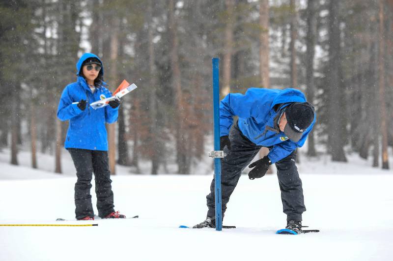
(Left to right) Angelique Fabbiani-Leon, state hydrometeorologist, and Andy Reising, water resources engineer, both from the California Department of Water Resources Snow Surveys and Water Supply Forecasting Unit, walks in the deep snow during the measurement phase of the third media snow survey of the 2024 season at Phillips Station in the Sierra Nevada Mountains on Feb. 29, 2024. The survey is held approximately 90 miles east of Sacramento, off Highway 50 in El Dorado County. (Sara Nevis / California Department of Water Resources)
After a slow and dry start to the water year, the state has ground to make in March. The snowpack is just under three-quarters of the April 1 average, when the state typically measures its peak, according to measurements from officials with the California Department of Water Resources.
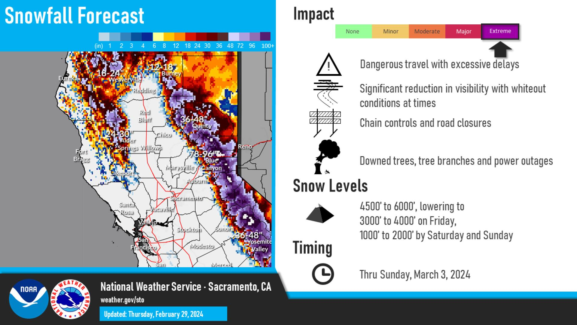
Enter what is being billed as the biggest snowstorm of the year, which started pummeling the Sierra with snow Thursday morning. The National Weather Service predicts the cold storm moving over the state could drop more than 12 feet of snow on the Sierra, boosting the snowpack and easing the state’s water woes.
Related Stories
“We have a decent storm coming this upcoming weekend,” said Angelique Fabbiani-Leon, California’s state hydrometeorologist, speaking at the Phillips Station snow course, south of Lake Tahoe, during the Department of Water Resources’ monthly snowpack survey press conference on Thursday. “This will help, but it will take several additional storms within March to really get us from the current 70% of April average up to 100% of average by the 1st of April.”
Sponsored
Many of California’s storms this year have been warm, with rain falling instead of snow and lots of precipitation landing along the coast. The snowpack supplies around 30% of California’s water needs.
“California has seen several extreme climate events so far this water year, including record rainfall in Southern California,” said state climatologist Michael Anderson. “While this pushed statewide precipitation above average, the snowpack still has not caught up from the dry conditions earlier this winter, and local conditions still vary significantly from region to region.”
Statewide, the precipitation total is 103% of average, and major reservoirs are currently 119% above average. Even though reservoir levels are in decent shape, state officials said snowmelt runoff could be below average if more storms don’t build up the snowpack in the coming month; the state could find itself in what officials call a “snow drought,” with above average precipitation and below-average snowpack. The next snow survey is on April 2.
“While conditions have dramatically improved since the beginning of the year, March will be critical in determining if we finish above or below average,” said Karla Nemeth, director of the California Department of Water Resources.
UCLA climate scientist Daniel Swain is more bullish on the storm’s chances of pushing California into above-average snowpack territory. He said even though the snowpack is “going to change dramatically over the next 48 hours.”
“This will be another snowstorm probably for the record books in some places,” he said. “When all is said and done, it’s quite likely that the Sierra snowpack will be significantly above average, just about everywhere in as little as a week.”
Swain said this massive cold storm after relatively warm conditions resulting in a below-average snowpack may be an example of climate whiplash, the phenomenon of rapid swings between extremes in weather bolstered by human-caused climate change.
“There’s this interesting notion of how we’re still seeing these really extreme snowfalls that are remaining as intense as they have ever been, and perhaps even getting a little more intense even as the average snowpack declines and as the number of really terrible snow years increases,” he said. “Those are not necessarily a contradiction in terms because, as you can imagine, even in a warming climate, you still sometimes get an atmosphere that’s cold enough for snow.”