upper waypoint

Sierra Braces for Peak of Severe Storm, With Over 10 Feet of Snow Possible

Save ArticleSave Article
Failed to save article

Please try again

A fast-moving storm drops several inches of fresh snow along Highway 50 near Echo Summit on Feb. 8, 2024, in South Lake Tahoe.  (George Rose/Getty Images)

Updated 9:30 a.m. Friday:

The first wave of what the National Weather Service has said will be the most extreme Sierra snowstorm in several years is behind us, having moved over the mountain range Thursday evening.

But the snow kept flying overnight:

An update posted at 3:40 am on Friday by the National Weather Service’s Sacramento office said that satellite imagery shows the next wave of this storm approaching the California coast, “which will bring another increase in precipitation by [Friday] afternoon along with a chance for thunderstorms.”

“The peak intensity of snowfall rates still appears on track for later this afternoon and overnight across the Sierra,” said the agency. Wind gusts will also increase on Friday, ripping at 45-55 mph through the Central Valley, and faster than 75 mph over mountain peaks.

Lower elevations in the region will now also see snow over the next two days. “Snow levels have lowered to around 3000 to 4500 feet, and will lower further to 1000 to 2000 feet Saturday,” the forecast said.

Their core message with this storm has not changed: “Extremely dangerous to impossible mountain travel is expected.”

Snow will come down at rates of 2 to 4+ inches per hour, which will close roads and produce white-out conditions.


Palisades Tahoe announced Friday morning that it would close for the day, with other ski slopes including Heavenly Ski Resort, Northstar California Resort and Sugar Bowl Resort also partially closing their terrain.

Update Thursday 11:56 a.m.: 
The huge Sierra storm is here. The forecast from the National Weather Service’s Sacramento office remains largely unchanged, with meteorologists ringing all kinds of warning bells about a blizzard that they expect to be the most severe of the past few winters – one that will create “extremely dangerous to impossible” travel conditions from Thursday afternoon through Saturday.

By the weekend, snow will be accumulating as low as 1000 feet, which could mean snow cover on low-elevation foothill cities like Applegate and Colfax (and potentially on Bay Area peaks like Mount Diablo and Mount Tamalpais)

Wind gusts will whip to 75 mph over the mountains, combining with heavy snowfall rates to create “near zero visibility at times” beginning on Thursday but especially on Friday and Saturday. The weather service continues to tell people not to drive in the Sierra during the storm.

The agency’s latest weather forecasts also mention the possibility of thunderstorms for interior Northern California on Friday and Saturday afternoon.

“Hazards from any T-storms that develop will include additional gusty winds, small hail, brief heavy rain and lightning,” said the Sacramento office’s latest forecast discussion. “As far as rainfall goes, much of the Valley will likely see generally less than 1.50″ inches through Saturday night. The foothills will see 2–4 inches, and the mountains will see 4–8 inches with locally heavier amounts.”

Original Story Feb. 28:

The Sierra Nevada could receive more than 10 feet of snow over the next three days as a massive cold storm encapsulates Northern California, according to the National Weather Service.

“This is probably the biggest snowstorm potential that we’ve had in the last three years and the coldest storm we’ve seen so far this winter,” NWS Sacramento meteorologist Craig Shoemaker said. “That time [in 2021], Highway 50 was closed for days. There were a lot of trees down from that system, and power was out for a long time.”

Meteorologists issued a rare blizzard warning from 4 a.m. Thursday until 10 a.m. Sunday and are warning of the possibility of zero visibility. They strongly advise people to only travel in the mountains once the storm clears. The agency also issued a similar blizzard warning in late February last year, closing highways into Tahoe and an avalanche.

“We’re expecting dangerous travel conditions, there are likely going to be highway closures, and there’s going to be whiteout conditions at times,” he said. “There should be no travel anywhere over the Sierra, heading in on Friday and Saturday.”

The massive cold air mass is moving down the West Coast from the Gulf of Alaska. The agency forecasts “a tremendous amount of snow” and wind conditions of up to 50–80 miles per hour in the Sierra, which could down trees and power lines.

“The storm will bring snowfall rates of 2 to 4 inches per hour at times,” said Courtney Carpenter, NWS Sacramento Warning Coordination Meteorologist. “It’s really going to pile up pretty quickly and make things nasty.”

Carpenter said snow conditions could drop to as low as 2,000 feet in foothill areas as the storm progresses.

For ski resorts like Heavenly in South Lake Tahoe, all the snow is great for business, and resort officials said they do not yet plan to close down. They advise visitors to either head up the mountain before the storm arrives or to follow travel advice from the weather service.

“A lot of the powder hounds are excited to get out there in the deep stuff and have those fresh tracks,” said Cole Zimmerman, communications manager with the resort. “With that being said, we do expect heavy winds. There’s a chance that some of those upper mountain lifts could be closed down because of winds that could reach up to 100 miles an hour.”

Zimmerman said the resort is watching the storm closely and will close down when people’s safety is in jeopardy.

“There’s such a thing as too much snow in the short term because you have to dig out lifts and chip off snow and ice off those lifts,” he said. “But in the long term, it ends up being a good thing.”

What will 10+ feet of snow do for the state’s snowpack?

While the potential of 10 to 12 feet of snow holds much promise for the snowpack, Andrew Schwartz, lead scientist at the UC Berkeley Central Sierra Snow Lab, said weather models have routinely overestimated snow and rain levels this water year. He expects 7 to 9 feet of snow across the Sierra.

Related Stories

“They’ve been overdoing it with expected amounts of precipitation all season and that makes us a little bit weary to throw big numbers out there,” he said.

For people who live in the Sierra or are visitors, Schwartz recommends buying three to five days’ worth of supplies, including food, water and flashlights. He said the best option is to hunker down in place once the cold winter storm hits.

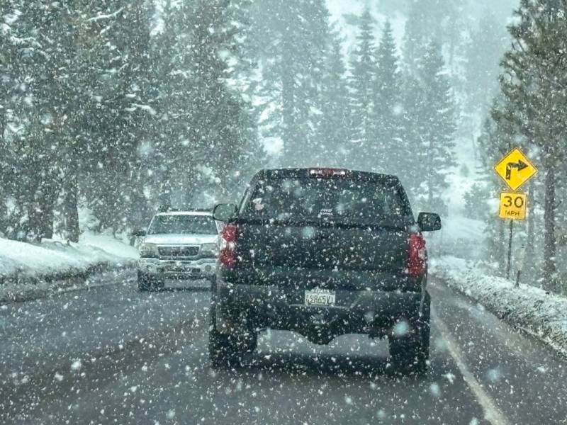
“Preparing for these storms is akin to preparing for a hurricane,” he said. “People living here are putting plywood on their windows to prevent the snow from shedding off their roofs and shattering them.”

Schwartz said all this snow could bring the snowpack to just at or above average for the year. At the moment, the snowpack is 71% of the April 1 average, which is the timeframe water managers look to as an indicator of potential water supply for the rest of the year.

“Even if we got 10 to 12 feet of snow, we would still need another 2 to 4 feet to get us to the average for the entire year,” he said. “It’s not likely to be one-storm-that-fixes-all type of thing. But with that being said, it’ll definitely get us very close to that point.”

Thunderstorm potential, Bay Area snow, and more

The storm has about a 20% chance of creating thunderstorms over the foothill and the Sacramento Valley that could contain hail and lightning. Flooding risk is minimal because of the cold nature of the storm, but local nuisance flooding is possible.

Bay Area peaks like Mount Diablo and Mount Hamilton could glow white as the sizable cold storm passes over the region starting Thursday and lasting through Saturday, according to the National Weather Service.

“Snow levels look like they’re going to get down to about 1,800 to 2,000 feet,” NWS Bay Area meteorologist Dalton Behringer said. “It should be a nice site with green hills and snow-capped mountains.”

Behringer said the storm could drop up to an inch of rain in most parts of the Bay Area. Coastal mountains could receive a few inches of rain, and nuisance flooding could occur.

“We’re just going to be dealing with cold rain and cloudy, dreary conditions,” he said.

He said wind gusts could top out around 40 miles per hour across the region, and the agency has issued a high surf warning along the coast with waves of up to 15 feet.

When the storm passed over Northern California, Schwartz said there were “hints” that there could be another storm in a week to 10 days after the storm.

“As far as one storm after the other coming through, that’s probably somewhat unlikely,” he said. “But maybe the occasional big storm weeks apart is still very much in the cards as we move forward.”

Sponsored

Sponsored

lower waypoint
next waypoint
Bay Area Cities Push to Legally Validate Polyamorous FamiliesCalifornia’s New 1600-Acre State Park Set to Open This SummerWhat Is the 'Green Flash' at Sunset — and How Can You See It?California's Plans for Slowing Climate Change Through Nature-Based SolutionsSame-Sex Couples Face Higher Climate Change Risks, New UCLA Study ShowsHoping for a 2024 'Super Bloom'? Where to See Wildflowers in the Bay AreaEverything You Never Wanted to Know About Snail SexEver Wake Up Frozen in the Middle of the Night, With a Shadowy Figure in the Room?Homeowners Insurance Market Stretched Even Thinner as 2 More Companies Leave CaliforniaThese Face Mites Really Grow on You