The physical channels of interconnected headwaters, streams, and rivers on earth support and are supported by a complex web of life, active above and below the water line. Working together, the river basin systems are able to trap floodwaters, recharge groundwater supplies, remove pollution, feed downstream waters, and provide abundant niches for fish and wildlife. Rivers and their watershed systems are the only “corporations” on earth that manufacture clean water every day, and for free. This infographic is part of the Water series.
Introductory Questions
- Where does your drinking water come from: surface water, private well, public well, or rainwater?
- How many rivers in the U.S. do you think are in good health?
Discussion Questions
- Why do streams and rivers wiggle around so much? Watch the three-minute video Recipe for a River from Science Friday to find out.
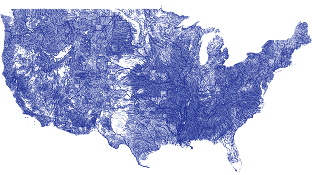
- Click for a pdf of the map of rivers and explore the pattern of waterways in the U.S. Can you draw watershed boundaries of the major watersheds?
- Locate your county on the EPA’s Drinking Water Map. Approximately how many people in your county get their drinking water from streams?
- If one in three people in the U.S. obtains drinking water from stream water, from where do the other two out of three people get their drinking water?
Follow-up Questions
- What makes freshwater unsafe for drinking?
- Is your drinking water treated? If so, where and how is it treated?
- Who pays to keep freshwater safe for drinking?
Extension Activity
- Investigate the costs and benefits of drinking only bottled water at home.
Links to Learn More
- What is a Watershed?, Kentucky Educational Television (available through PBS LearningMedia)
A two-minute video illustrating the watershed concept - Surf Your Watershed, EPA
A portal to links about every watershed in the U.S, including environmental information, USGS data, citizen monitoring groups, and assessments of the watershed's health - Mountaintop to Tap, Stroud Water Research Center
Watch twelve lively teenagers hike, camp, explore, take photographs, learn, and dance their way along the path of New York City’s water supply system -- from mountaintop to tap -- in this 37-minute video.
NGSS Correlations
- Performance Expectation: Plan and conduct an investigation of the properties of water and its effects on Earth materials and surface processes. HS-ESS2-5
- Disciplinary Core Idea: The abundance of liquid water on Earth’s surface and its unique combination of physical and chemical properties are central to the planet’s dynamics. ESS2.C
- Crosscutting Concept: Stability and change
- Engineering Practice: Planning and carrying out investigations