upper waypoint

Geological Outings Around the Bay: Los Trancos Open Space

Save ArticleSave Article
Failed to save article

Please try again

While you're visiting the San Andreas fault, don't overlook the local rock, an excellent conglomerate. Photos by Andrew Alden

Due south of Stanford, way up in the high hills, Los Trancos Open Space Preserve offers an excellent place to study the San Andreas fault. The preserve has a well-annotated trail that will show you good examples of the odd landforms and disturbances found all along the fault from Point Arena to the Salton Sea. Craig Rosa presented this trail for KQED QUEST a few years ago, and I can't improve on that. But since that time, geologists have gained a thrilling new tool for seeing landscapes: lidar mapping.

Lidar is laser-based radar. An airplane-mounted laser sprays the ground with tiny, precise laser pulses, and the time it takes for the light to return is measured. Our equipment is good enough to turn those times into distances, with precisions measured in centimeters. Every one of those millions of measurements—distances and GPS positions—is painstakingly recorded and poured into a database called a point cloud. It's a cloud because it's a blurry mixture of returns from treetops, shrubbery, buildings, flying birds and whatnot as well as the ground surface. But all that cruft can be digitally removed to show only what geologists care about: the bare land. (Foresters, on the other hand, love the way you can extract the treetops and map the woods itself.)

Here's what Los Trancos looks like in Google Maps. The San Andreas fault trail runs through thick oak woods in the valley of Los Trancos Creek. The fault itself runs from an inch right of the top-left corner to an inch left of the bottom-right corner.

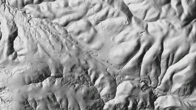
See it? Not really. The fault trace was mapped by people in boots, with the help of historical photos that showed the rips in the ground from the 1906 earthquake. Now have a look at the digital elevation model built from lidar data and digitally illuminated from the left.

Sponsored

This is what makes geologists use forbidden words like "revolutionary" when they give talks about lidar. To their trained eyes, this image has all kinds of information in it. It shows the stuff we've already mapped, plus many more subtle features we could go back and look for.

To me, most obviously, this image shows disorganized landslide topography along the western, uphill side of the fault trace. It suggests to me that one of the exhibits along the fault trail may need to be corrected: station 8 has a set of posts in the ground marking "a minor fault," but it is much more likely to be a landslide scar. Check it out yourself on the ground and see what you think.

You can play with the lidar data yourself, using Google Earth and getting the data from the National Center for Airborne Laser Mapping. I did that to make the image below, which is from a higher elevation and tilted counterclockwise a bit.

We can see the fault cross Page Mill Road and head down behind Black Mountain along the headwaters of Stevens Creek. The fault guides Stevens and Los Trancos creeks right up to the road where the land forms a saddle, at the center of the image. This view looks down to that saddle.

And if you cross the road to the Monte Bello Open Space Preserve, you can follow the fault into the heart of the Santa Cruz Mountains.

That's the fault coming in from the left in the strip of woods, then curving slightly to the left and exiting the horizon where the mountains are lowest. The highest of those distant peaks is Loma Prieta itself, which gave its name to the October 1989 earthquake by virtue of being the nearest notable landmark. Consider this picture an invitation to blaze your own self-educational trail along the fault.

lower waypoint
next waypoint