upper waypoint

Geological Outings Around the Bay: Mount Vaca and the Monticello Dam

Save ArticleSave Article
Failed to save article

Please try again

The Monticello Dam occupies Devils Gate, a deep cleft in the massive sandstones of the Great Valley Sequence. Photos by Andrew Alden

This outing visits two great landmarks of the northeastern Bay Area—one highly visible, the other well hidden. Both feature the same body of rock: the mighty Great Valley Sequence.

Most of Northern California's bedrock is part of just three large bodies: the granite of the Sierra, the metamorphic rocks of the Coast Range, and the sedimentary rocks of the Central Valley. All three are parts of one entity: a former subduction zone. Picture the Pacific seafloor plate being carried eastward against the North American continental plate and plunging underneath it—subduction. (That's the exact situation today in the Pacific Northwest, and along the whole west coast of South America.) The descending oceanic plate releases fluids into the continental plate above it, which generate magma and big chains of volcanoes. At the same time, the continent scrapes off pieces of the plunging oceanic plate like the bottom of an escalator gathers trash. The volcanoes quickly erode into sediment, which washes offshore in thick beds of sand, boulders and silt. The Sierra is the exposed roots of the volcano belt, the Franciscan Complex is the scraped-off stuff, and the Great Valley Sequence is the offshore sediment.

That all happened long ago, and since then the San Andreas fault has slowly ripped apart the neatly organized subduction zone. At the same time, pressure across the fault has pushed up the Coast Range and curled up the edge of the thick blanket of sedimentary rock in the Central Valley. The arrangement is still close to its original simplicity north of the Bay Area, as this map shows.

Modified from USGS Open-File Report 90-226

Below is a closer view of the setting for today's outing. The south end of that long ribbon of Great Valley Sequence rocks is the Vaca Mountains, and the highest part of the range is a sharp hogback called Blue Ridge.

From USGS map MF-2403, "Geologic Map of the Northeastern San Francisco Bay Region"

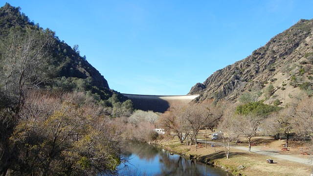
Mount Vaca is its highest point, at the west edge of the leftmost green ribbon to the left of the "i" in "Ridge." If you follow that geologic boundary north, it meets the dam that created Lake Berryessa, Monticello Dam.

Sponsored

Blue Ridge is a massive landmark wherever you are in the Napa County hills or the southern Sacramento Valley. It's high, long and straight. West of Winters its profile is interrupted by a big notch. This is the Berryessa water gap, carved by the waters of Putah Creek as the ridge rose across it.

You reach Mount Vaca by taking Pleasants Valley Road north from Fairfield. Two very steep roads go up the mountain, Gates Canyon and Mix Canyon roads. Take Mix Canyon Road (trust me, don't take Gates) and watch carefully for cyclists and descending vehicles. Soon you'll start seeing Great Valley rocks like this thick-bedded sandstone, tilted almost vertical. The sequence is estimated to be about 13 kilometers thick, representing some 80 million years of steady erosion of the Sierra highland into a nearby shallow sea (a foreland basin). The basin steadily sank from the load, like the Louisiana coast does under the sediment load from the Mississippi River.

The rocks grow younger from west (right) to east (left).

At the top of Mix Canyon Road, a spur marked "Private" goes left. Go ahead and take it to reach Mount Vaca. The right-hand way, Blue Ridge Road, is also highly scenic. Two-wheel drive is OK, but drive cautiously. The views from along the top of Blue Ridge are fantastic.

Grapevines and Mount Tamalpais from Blue Ridge. At about 2600 feet, this may be the highest vineyard in California.

The ridgeline rocks are massively bedded sandstone of the Venado Formation, roughly 91 million years old. We'll get a better look at them next, at Devil's Gate.

Return down to Pleasants Valley Road and resume heading north. Notice the recent downcutting of the stream here. Turn west on state route 128 and head up the canyon of Putah Creek. Instead of climbing Blue Ridge, we're cutting through it. Devil's Gate is the deepest part of the canyon, where the stream crosses the Venado Formation, and the best spot to build the Monticello Dam.

On both sides of the dam, the Venado is beautifully exposed. This is the natural exposure on the far side of the dam. Roadcuts on the near side expose the Venado in real detail.

If Lake Berryessa is high, you may be treated to the sight of the dam's "Glory Hole" overflow structure, an endless circular waterfall that I photographed in action in May 2006.

lower waypoint
next waypoint