
If a megathrust earthquake struck the modern world, most of us would know about it within seconds. Bill Steele, Director of Information Services at the Pacific Northwest Seismic Network, would get a detailed account from an extensive array of seismometers located around the globe. Regular citizens would probably get an email, tweet, or Facebook note from a friend.
But what if the quake hit hundreds of years ago? How were scientists able to determine that a Cascadia Subduction Zone megathrust trembler hit sometime between 9:00 and 10:00 p.m. on January 26, 1700?
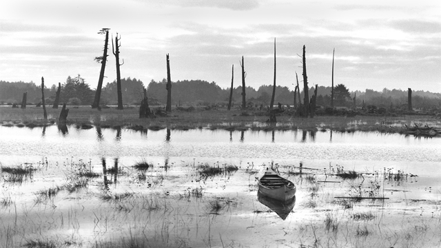
The story starts in the 1980s when geologist Brian Atwater, dendrochronologist David Yamaguchi, and others began to investigate the Pacific coast of Oregon and Washington. Traveling by foot and boat through the region’s many bays and river mouths, the scientists examined thousands of dead western red cedar and Sitka spruce. The trees had not fallen to the ground but stuck upright out of the sand in great groves, known as ghost forests.
Intriguingly, James Graham Cooper, a naturalist living on the Washington coast in 1853-1854, had noticed the dead trees, too. He thought they had died slowly, sinking into quicksand. Atwater, however, knew differently. When a magnitude 9.5 earthquake hit Chile in 1960, coastal marshes had dropped several feet, allowing sea water to flow in and quickly kill the trees.
Because the spruce and cedar still stood in place, Atwater and Yamaguchi realized they had a clock that would tell precisely when the trees died. All they had to do was look at the trees’ growth rings. Those rings would reveal how the trees had lived and when they had died.