
As a child, I loved stories that featured secret passages and hidden rooms. I cherished the suspicion that there was a different world beneath this one—or around some corner where it was waiting to meet me. C. S. Lewis, H. P. Lovecraft, even Thoreau fed this feeling. Then I discovered geologic maps and felt something of the same thrill.
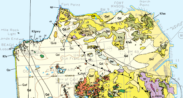
Consider the glimpse beneath San Francisco in the image above. Telegraph Hill stands out in the upper right corner, a near-island of old bedrock surrounded by artificial fill (Qaf). Once upon a time, North Point was really a point. What is that odd river of purple, marked by dotted lines? Isn't that big purple blob Potrero Hill? Isn't that orange patch Mount Sutro? The rocks in the two places must be completely different! And that light color marked "Qd"—that must mark the old sand dunes that got turned into Golden Gate Park and paved over everywhere else.
The map's explanation provides all the letter codes (and yes, Qd stands for Quaternary dunes) and keys to the symbols. It won't tell you everything; even all this detail is just a sketch. But it will give you a set of clues, in the form of literature citations, that you could pursue in a university library. And of course the map patterns are another set of clues that you could pursue in the field. Slowly, with the map's help, you can learn to perceive the hidden rooms of the landscape.
If this kind of thing excites you, then you owe yourself a visit to the Map Sales Room on the U.S. Geological Survey's campus in Menlo Park. Yes, most of these maps are available online at store.usgs.gov, but (1) the USGS store includes products from the state geological survey too, and (2) there is still something about well-selected inks on strong paper.
One map worth starting with is the "Geologic Map of the San Francisco Bay Region" poster. It's packed with explanation to help you get the most from the map. You can peruse the whole poster online in PDF or Google Earth formats and explore it directly by zoom and pan, but for seven bucks the paper version is a bargain.