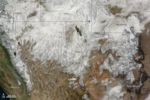
 Satellite image of the western United States, taken on Thanksgiving Day. Image: NASA.This Thanksgiving weekend, Bay Area skiers had a lot to be thankful for--ski resorts in the Lake Tahoe area received over 170 inches of snow throughout the weekend. But heavy snow and rain are not expected to continue in the Bay Area, because the world is experiencing a La Niña.
The defining sign of a La Niña is cooler-than-average sea surface temperatures in the Pacific Ocean, near the equator. Cooler water evaporates less than warmer water, so there is less moisture in the air. This means that during a La Niña, there is less precipitation in some areas, like California and the southern United States. Other areas, like the Pacific Northwest, get more precipitation during a La Niña. (Book your winter ski trip strategically!)
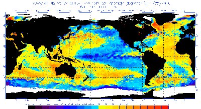 Sea surface temperature anomalies on November 25, 2010. The equatorial Pacific is cooler than usual (note the blue color), a characteristic of a La Nina event. Image: NOAA.La Niña also affects air temperature. During a La Niña, the South is typically warmer, while Southern California and the Pacific Northwest are cooler. You can see climate predictions for the next three months, from the National Weather Service Climate Prediction Center.
A La Niña is basically the opposite of an El Niño. El Niños are characterized by warmer-than-average sea surface temperatures in the equatorial Pacific. This happens when the atmospheric pressure system gets a bit out of whack. Usually there is high pressure over the Pacific Ocean and low pressure over the Indian Ocean—picture a see-saw anchored over New Zealand, with the heavy kid sitting on the end over Indonesia. For reasons we don’t quite understand, sometimes the see-saw tilts the other way—now the heavy kid is sitting in the southeastern Pacific, and the kid on the Indonesian side is way up in the air.