upper waypoint

Greater Bay Area Geo-Attractions: San Gregorio Beach

Save ArticleSave Article
Failed to save article

Please try again

This week's post is the second in a series highlighting locations around the Bay Area that combine beautiful scenery with great geology. Check out the first post in the series about Point Reyes National Seashore.

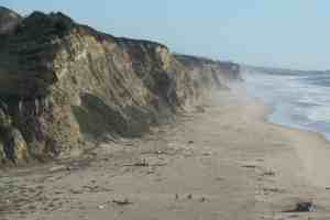
San Gregorio State Beach is approximately 40 miles south of San Francisco near the junction of Highway 1 and 84. This beach is one of my favorite spots along the coast between Half Moon Bay and Santa Cruz.

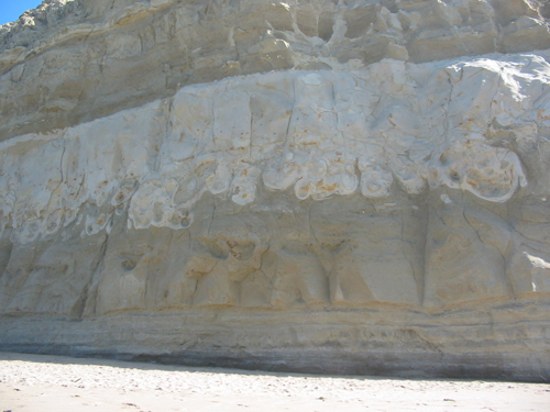
The rocks that are exposed in the beach cliffs are a marine sedimentary unit called the Purisima Formation which was deposited between 2.5 and 7 million years ago. The part of the Purisima that is exposed in the cliffs at San Gregorio beach is called the Tahana Member and is characterized by fine-grained sandstone and silty mudstone. The whiter layers contain a lot of volcanic ash that are chemically similar to volcanic deposits of the Snake River Plain in southern Idaho.

One of these volcanic ash-rich layers is noticeable in this photograph below (for scale, the height of base of whiter layer is approximately 10-12 feet from beach). Note how irregular and convoluted the bottom boundary of the whiter layer is. This is most likely a result of what geologists call 'soft-sediment deformation', which basically means that when the whiter sediment was deposited it sank into the underlying layer (think lava lamp). These sedimentary layers were deposited in a marine setting and there was still a lot of water in the sediment making it quite soupy and soft.

Sponsored

The Purisima Formation is also known for the fossils it contains. If you look carefully you'll find mollusks low in the cliffs just to the north of where the path leads down to the beach. There are also abundant trace fossils. Trace fossils aren't remnants of hard body parts like shells or bones, but of animal activity that disturbs the sediment leaving a trace. In this case, there are numerous burrows preserved in the lithified sediment from small critters that lived in the sand.

Read even more about the Purisima Formation in this USGS Open-File report by Charles Powell and others.

Below is a geologic map pointing out the distribution of the Purisima Formation (in light beige color) and the major tectonic feature of this area -- the San Gregorio Fault, which is a fault associated with the San Andreas Fault System.

Although these faults are dominantly strike-slip faults -- in which the motion is lateral -- there is still quite of bit of compression that results in uplift. As you drive down Highway 1 you'll notice flat terraces above the current beach. Such marine terraces were formed by wave action when it was at sea level and they've since been uplifted. The timing of the formation and uplift of the rocks is much younger than the deposition of the sedimentary rocks.

The photograph above from the California Coastal Records Project shows how San Gregorio Creek forms a small estuary just behind the beach. The cliff exposures of the Purisima Formation discussed above are along the beach below the main parking lot.

I actually haven't been to San Gregorio beach in a couple of years. The mouth of San Gregorio Creek shifts around quite a bit at the beach. Last time I was there it was  difficult to get around some of the cliffs without getting your feet wet. I'm not sure where the creek is right now, maybe someone who's been there recently can comment below.

Finally, when you're done walking on the beach and checking out the geology, head over to Duarte's in Pescadero for some artichoke soup and olallieberry pie.

~

Images: (1) from my personal collection; (2) from my personal collection; (3) part of geologic map from USGS Open-File Report 98-137, Geology of Onshore Part of San Mateo County California ; (4) California Coastal Records Project

37.227813475235685 -122.43775178678334

lower waypoint
next waypoint