
A few months ago, the QUEST television program included a segment on various gelatinous marine animals, including jellies, found offshore of central and northern California and featured at the Monterey Bay Aquarium. The beginning of the video segment briefly showed one of the most important habitats for these animals — Monterey submarine canyon. Not unlike on land, features of the undersea landscape have a significant influence on the quantities and diversity of animals. Science involved in understanding the relationship of this “seascape” with submarine ecosystems requires quality maps and the technology to create those maps is improving all the time.
For this post, I simply wanted to show a few images of the canyon and beyond. As readers on my regular blog know, I just love showing images of our planet’s seafloor. We are currently in an age of exploration and discovery when it comes to mapping the seafloor — in many ways it’s like sending probes to another planet. Many of the images I show in this post are from the Monterey Bay Aquarium Research Institute (MBARI), which has not only done a lot of the mapping and science, but has also designed and built the technology to do it. See their page on marine geology, including Monterey canyon, here.
The first image (below) shows the deepest part of Monterey canyon, near the shoreline, cutting across the flat and relatively shallow continental shelf. The yellow arrow represent river sources of sediment that contribute to the longshore currents (red arrows) that funnel the sediment into the canyon and, ultimately, into the deep sea.

In fact, it is the movement of sediment through the canyon that is responsible for creating and sculpting the canyon. Not unlike the Colorado River incising into the Colorado Plateau to create the Grand Canyon, these underwater “rivers” of mud, silt, sand, and water rush down the canyon eroding the canyon little by little. Since I’m bringing up the Grand Canyon, I always like to point out the scale of Monterey submarine canyon with the map below, which compares the two canyon systems at the same scale (also from MBARI).

Grand Canyon (top) and Monterey submarine canyon (bottom); credit: MBARI
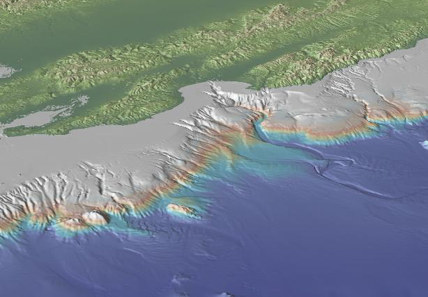
Finally, I’d like to point out that there is even more to discover and learn beyond the canyon itself. As the continental slope transitions to the much flatter open ocean floor (greater than 10,000 feet deep) the deep canyon transitions to a subtler feature. The Monterey submarine fan, shown in the map below, is a depositional feature — it’s where all the sediment that cut the canyon (and much more that simply traveled through it) ended up. This is the submarine equivalent of a delta in some ways.
