upper waypoint

Celestial Navigation: Finding Your Way in the Dark

Save ArticleSave Article
Failed to save article

Please try again

Earth's coordinates and the Celestial SphereI’m dusting off the plastic tub where I keep all the materials for my Celestial Navigation class, in preparation for teaching it again, starting March 4. It’s not a certification course for learning how not to get lost at sea, but an introduction to astronomy spun up with the theme of that ancient practical use for astronomy.

Though I’ve been teaching this subject since 1996, I was delighted to run across a pair of antique sextants purchased in the 1940s by Earle Linsley, Chabot’s second director, for use in his Celestial Navigation class!

Anyway, it’s a special topic for me as it blends my interest in astronomy with my long time fascination for things nautical: ships, exploration, adventure, and global geometry.

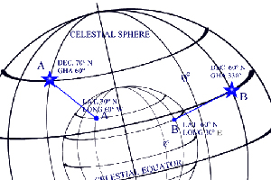
Fixing one’s position on Earth is one of the oldest practical applications of on-the-go astronomy (maybe not as old as working out the seasons and establishing standard periods of time—calendars—but possibly a contemporary craft). Long have sea-faring cultures in the Northern Hemisphere used Polaris to mark north and determine latitude. In the Southern Hemisphere, without the trusty North Star in view, navigators such as Pacific Islanders crossing that vastness in large canoes nevertheless memorized the locations of other stars at different times of the night and year to steer their courses from island to island.

Arab caravans crossing the Sahara desert used Celestial Navigation so as not to get lost on the endless waves of sand dunes. The astrolabe—an instrument used to measure star altitudes to help plot position—was developed originally by Arab desert caravan drivers, not for sea-faring ships!

Sponsored

How does it work, in a nutshell? Well, more recent Celestial Navigation techniques—the kind portrayed by sextant-wielding navigators plotting lines and circles on paper charts—boils down to the older concept of the Line of Position. If you can see and identify a landmark somewhere on the horizon (a mountain, an island, the end of a peninsula, an exceptionally large and well known tree), and you can measure what direction it’s in (e.g., with a compass), you can draw a line on a chart through that landmark running in the measured direction, and you can reason that you must also be located somewhere on that line. If you can plot another line for another observed landmark, then you can reason that you must be located where the two lines cross. Get it?

Using stars as "landmarks" was the leap from land-based positioning to Celestial Navigation. Imagine a given star as the top of a ridiculously tall landmark, or lighthouse, rising high above the point on the Earth it sits directly over—the star’s "geographical position." The angle you measure between the star and the horizon (the star’s "altitude") depends on how far from that spot you are. If you’re at the star’s geographic position, then it’s directly overhead and makes an angle of 90 degrees with the horizon. The farther you are from that spot, the lower in the sky you will measure the star.

The key is to see that for any specific altitude measured for a star, you must be located somewhere (anywhere) on a giant circle on the Earth that is centered at the star’s geographic position. It’s like standing a certain distance from a flagpole and measuring the angle to its top: you’ll get the same measurement from anywhere along a circle drawn around the flagpole, but step closer to or farther away from it and the angle changes.

Measuring a single star’s altitude gives you a circle of position on Earth, somewhere on which you are located. Measure a second star and draw its circle of position and the two circles will cross each other at two locations—and you can reason that you are located at one of the two. Measuring a third star and a third circle of position should clinch the deal, marking your terrestrial position where the three circles intersect.

Modern GPS works similarly by measuring your position relative to several orbiting satellites, using the time delays in radio signals between satellite and GPS receiver to calculate a sphere of position surrounding each satellite. You are located somewhere on that sphere of position, and where multiple spheres intersect at the same point, there you be.

So, where are you today?

37.8148 -122.178

lower waypoint
next waypoint