The parking lot is closed on weekends, except for permitted events. To obtain a permit for your wedding or group event, call the SFPUC at 650-872-5900.
Nearby Open Space Attractions
The newly-opened portion of the SFPUC Peninsula Watershed’s Fifield-Cahill Ridge Trail, accessible through guided tours, starts at Skyline Quarry on Highway 92 and extends northward to the watershed boundary at the Portola Ridge Gate, where it connects with the Golden Gate National Recreation Area trail system and the Sweeney Ridge section of the Bay Area Ridge Trail. For tour reservations, see trail.sfwater.org or call 650-652-3203.
The historic Sawyer Camp Trail-once a segment of the main route between San Francisco and Half Moon Bay-winds approximately six miles through SFPUC Watershed land from Crystal Springs Reservoir to San Andreas Lake.
Special thanks to John Fournet and Betsy Lauppe Rhodes of the San Francisco Public Utilities Commission, for assisting us on this project.
Hiking the Peninsula Watershed: Gaining a new view on water and resource conservation
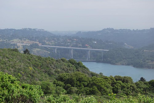 Crystal Springs reservoir, a familiar sight from Interstate 280, has helped serve San Francisco’s water needs since it was dammed in the 1880s. The dam, made of interlocking concrete blocks, survived the 1906 earthquake with little damage. The four reservoirs of the Peninsula Watershed are in the valley created by the San Andreas fault.
It flows downhill for miles and miles until it reaches your tap. On its way, it passes towering fir forests, distinctive grasslands, and the habitat of many rare and endangered species. It's San Francisco's water, resting on the San Andreas fault, replenished constantly by the cycles of nature, and delivered to you via ingenious Civil War-era engineering.
The history and nature surrounding the San Francisco Peninsula Watershed make it much more than a pastiche of hillsides and reservoirs. The watershed, managed by the Public Utilities Commission, is home to trails that offer access to remote wilderness, Northern California geology, and unique opportunities to appreciate the complexity of providing 2.4 million people with a clean water supply.
Some trails follow the outlines of reservoirs; others lead to hillside hikes that provide wide-angle views of the watershed. The Sawyer Camp trail, one of the most heavily used in the Bay Area, skirts the edges of Crystal Springs and San Andreas reservoirs, via a six-mile accessible paved path. At the northern edge of PUC land is the Sweeny Ridge trail, managed by the national park service, a 600-foot climb to sweeping views and a favorite with mountain bikers.
Visiting the two areas we've explored here on the QUEST website lends a dual understanding of the watershed and its simultaneous protection from and integration into the surrounding metro area. The Fifield-Cahill Ridge trail, in a carefully preserved area that includes old growth Douglas firs, demonstrates differing views of conservation measures taken over 15 decades. On the other side of interstate 280, a hike starting from the Pulgas Water Temple gives visitors a chance to ponder the enormity of the task of bringing water halfway across the state, downhill through the mountains, to a growing Bay Area population.
The Fifield-Cahill Ridge trail
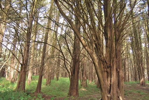 A stand of Monterey pines along the Fifiled-Cahill Ridge trail serve as a reminder of past conservation ethics, when ecologists deemed tree-planting as a most vital activity. Though they are from the nearby Monterey Bay region, these trees aren’t native to these more northern hills. They were likely planted in the 1930s, possibly to promote fog drip in the hopes that it would contribute to the reservoirs. Running a 10-mile length through the area's many habitats, the Fifield-Cahill trail may be the watershed's most special excursion. It was closed to the public until 2003, and even now only parties of 20 or less are allowed, and must be accompanied by a trail guide. Why? It's all in the interest of preserving the habitat and resources here, and protecting the reservoirs from fire, erosion, and pollution.
You can make reservations to explore the trail on foot, bicycle or horse by visiting trail.sfwater.org.
Along the trail, hikers get views of all four of the watershed's reservoirs, as well as a vista of the city, old-growth forests, and a chance to glimpse some rare and endangered species. These reservoirs were the impetus for establishing a protected wilderness here 150 years ago, and they've been vital to the development of San Francisco. Their dams were all built between 1860 and 1880, and survived the 1906 earthquake, despite their locations along the San Andreas fault line.
The landscape here is perfect for catching rainfall. Coastal marine layers move on shore over the hillsides, dumping lots of rain into the rift valley. The area around Pilarcitos reservoir can sometimes receive four or five times the rainfall of the airport, which is only 5 miles away. On their own, the four reservoirs—Upper and Lower Crystal Springs, Pilarcitos, and San Andreas—provides about ten percent of San Francisco's water supply.
The Pulgas Water Temple and Sheep Camp trail
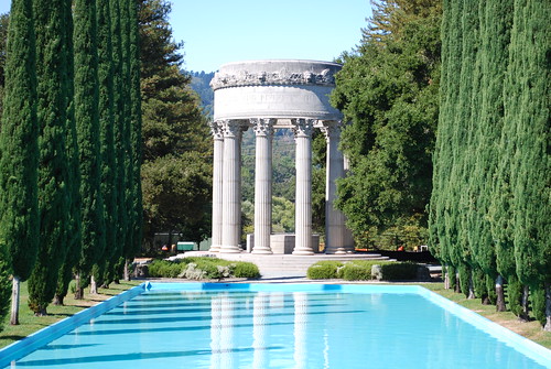 The Pulgas Water Temple was built at the terminus of the Hetch Hetchy aqueduct as a monument to the new water system. It’s located within the watershed, just south of Crystal Springs reservoir. An inscription at the top reads, “I give waters in the wilderness and rivers in the desert, to give drink to my people,” a biblical quote from Isaiah. So where does the rest of the city's vital H2O come from? The Pulgas Water Temple tells this part of the story, and a climb from the Temple to a nearby ridgetop affords broad brush views of the watershed, putting the whole water narrative together.
San Francisco long ago outgrew its four reservoirs. In 1909, with memories of the '06 earthquake's unquenchable fires still vivid, the city of San Francisco purchased land in the Hetch Hetchy Valley in Yosemite National Park with the intention to dam the Tuolomie river. The next year, the city voted to build the dam and a 160-mile-long system to carry the water from the mountains to the San Andreas valley, and in 1913 Congress allowed the construction. The effort expended was enormous: $45 million dollars, twenty years of construction, a few deaths and a great deal of politics. In 1934, the first rush of Hetch Hetchy water flowed through the gravity-driven tunnel system, across the California's central valley. It swooshed through the base of the Pulgas Water Temple and into nearby Crystal Springs reservoir while San Franciscans cheered, and some conservationists frowned.
 Signs at the start of the Sheep Camp trail let visitors know that this is protected land. The ascension up Sheep Camp trail connects the Hetchy water to its final destination. Climbing to the ridge top east of 280, hikers pass through coastal oak scrub, until reaching the viewpoint. Here, you can see across the valley, taking in Crystal Springs reservoir and the pine and fir stands that the Fifield-Cahill trail passes through, Trekkers with a fondness for geology will appreciate this scene: the reservoir in view sits atop the San Andreas fault, meaning that a hiker here is standing on one tectonic plate and looking out at another, the distant hills moving southward, ever so slowly.
Being able to see two tectonic plates isn't entirely uncommon in the Bay Area. But this vista brings together so much more: an illustration of how humans have made use of the valley created by these plate movements, and harnessed the landscape's natural slope and the resources in the mountains hundreds of miles east, all with the purpose of providing water—California's original gold—to the people who flock here for the very magic this set of hikes offers.
Visitor Photos
Join our Pulgas Water Temple Area photo group on Flickr to share your photos of this amazing place.
Additional Links