Today, there is one automated active Coast Guard station - at Point Blunt - on the island (this area is off limits). Angel Island became a State Park in 1954.
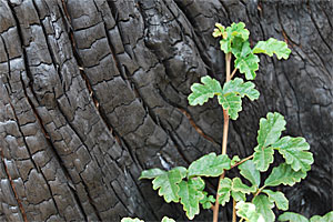
On October 12, 2008, Angel Island was ravaged by a wildfire. In just 2 days, 303 acres went up in smoke. We're visiting the island a year later to see how the land is recovering and learn how the fire helped one scientist unearth a bit of the island's history.
Getting There
Access to the Island is by private boat or public ferry from San Francisco, Tiburon and seasonal service from Oakland and Alameda. There is limited weekday ferry service to Angel Island during the winter.
Several ferries are available during the peak season to take you to Angel Island:
Oakland/Alameda Ferry
San Francisco Ferry
415-773-1188
http://www.blueandgoldfleet.com/
Angel Island-Tiburon Ferry
415-435-2131
www.angelislandferry.com
Tram Tours
415-897-0715
www.angelisland.com
Please be advised, Angel Island SP is one of the few California State Parks that does not accept the Annual Day Use Pass.
Operating Hours
High Season
8:00am to Sunset
Low Season
8:00am to Sunset
More Information
Angel Island State Park Home Page
Special thanks to Breck Parkman, Senior State Archaeologist for California State Parks and Silvia Lange, Docent at Angel Island State Park for assisting us on this project.
Doll parts, broken bottles, and buttons: Archaeology of Angel Island after the fire of October, 2008
While Angel Island has had few lifelong residents (human ones, anyway), there are plenty of folks who have spent long stretches of time there. From the time of the Civil War until World War II, there was a consistent presence of military men and their families stationed on the island, During their stays, these visitors managed to drop, discard, or leave behind many interesting traces of themselves. Senior State Archaeologist Breck Parkman has been sifting through artifacts on Angel Island for over 25 years, piecing together stories of the lives lived on this 700 acre patch of land in the middle of San Francisco Bay.
 The leg of a century-old ceramic doll recovered from a dump on Angel Island that was made visible by the Oct. 2008 fire. Photo: Breck Parkman
On October 12, 2008, a fire that started in one of the island's campgrounds burned just under half of Angel Island's acreage. Fires, of course, can be very destructive. But for an archaeologist, they can also be magically revealing, burning off foliage that may have long covered objects and impacts left behind by previous visitors.
Luckily, none of the historic buildings on Angel Island were lost. Instead, the fire burned away grasses and shrubs, exposing some features that archaeologists like Parkman had suspected were there, as well as uncovering some new surprises.
The Lay of the Land
Some of the most readily visible findings were on the surface of Angel Island's landscape, bared and blackened after the fire. In an area on the southern side of island, long dubbed "Alcatraz gardens," Parkman was surprised to find terraces and pipes that had been hidden for decades under the grassy groundcover. "It was one of the more dramatic things we saw after the fire, because with the grass burned, you could actually see landform," he recounts.
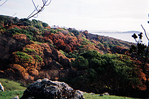 Vegetation burned to the ground in the area near East Garrison and other parts of the island, exposing landscapes that had previously been invisible. Photo: Silvia Lange
The 12 or so acres that was used to grow food for staff and prisoners at Alcatraz Island (there was no suitable soil for growing food on "The Rock.") is hard to see now that the grass has returned. But after the fire, Parkman saw terrace after terrace, with water lines feeding them. "You can see that this was a really flourishing garden for years that's now fallen into disrepair."
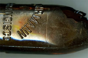
A beer bottle found hidden in some rocks along with several other bottles. The brewery imprinted on the glass closed in 1900, so the bottle is likely from the 1890s. Photo: Breck Parkman
On the newly bared surface of the island the fire also exposed several spots that had hidden collections of liquor bottles dating from the Spanish American war and World War II. Parkman sees these piles of bottles as an indication of boredom. Like the inmates at Alcatraz, enlisted men on Angel Island could feel very isolated, with their view of a twinkling city that they couldn't visit. "I saw gross boredom in the archaeological record," he says. "Men who spent years here felt like they were in prison."
A bit more mysterious is a stash of broken milk bottles revealed by the fire. Perhaps they held some alcohol smuggled onto the island? The story behind them will remain unknown for the moment.
"The small things forgotten"
Parkman found an even bigger treasure trove of new objects when he began digging below the scarred surface of Angel Island. He's long suspected there was a military dump near Camp Reynolds (waypoint 2 on the map), but he'd been unable to find it, despite numerous searches. It was the first place he came after the fire, and to his delight, Parkman found the site littered with thousands of artifacts, including buttons, hardware from clocks, belt buckles and heaps of glass and ceramic shards. Spent military cartridges dated the site back to the 1870s.
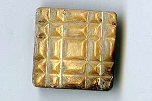
A mother-of-pearl brooch from the late 19th century dump. Probably belonging to an officer's wife, it is some of the evidence of the family life of military men stationed on the island. Photo: Breck Parkman
Though he'd worked on the island for decades, this was his first encounter with an abundance of items that demonstrated the presence of women and children: doll parts, miniature tea cups, a mother-of-pearl brooch. "This is the first time I really saw gender in the archaeological record," he notes. "There are artifacts that only children would use. The wives' artifacts were there, as well as things from the women who worked there, the house help." These items show that the dump was used by officers, and Parkman wonders whether the dump used by the enlisted men would look different, with bones from different cuts of meat, or shards from lower quality dishes. He won"t be able to answer that question, though, until he finds where the enlisted men left their dregs.
"A dump is sort of like a hidden collection of knowledge," Parkman says. He quotes anthropology professor James Deetz, calling these objects "the small things forgotten" in early American life. It's in a dump where you find those remnants of everyday existence. "As archaeologists, we're interested in the physical remains of culture," he says. "I"m looking at cultural landforms and artifacts that tell a story of how we've lived with this land."
All in all, the fire allowed Parkman to locate 13 new archaeological sites on Angel Island. "People say, 'What did you discover?' and I say I discovered bits and pieces. But that's really a no-brainer at a historic site after a fire. What's really interesting to me is that I've researched this island for years and I didn't know a lot of things I know now because of the fire."
Visitor Photos
Join the Angel Island photo group on Flickr to share your photos of this amazing place.
Credits
Video captured by Chris Bauer, audio & article by Robin Marks. Editing & photos by Craig Rosa.