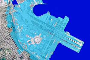
 Sea level rise scenarios for San Francisco International Airport.
Click the map to see a larger image.
The most recent estimate looks pretty dire. The Bay Conservation and Development Commission (BCDC), a state planning agency, says it expects San Francisco Bay to rise about 16 inches by 2050, and 55 inches by the end of the century.
The map on this page shows what San Francisco International Airport and the surrounding area would look like, if the bay rose a meter (roughly 36 inches). You can check other maps around the bay as well.
And the real danger of that big rise in bay waters happens during storm season. High tides and storm surges could send that higher water inland, flooding Highway 101 and neighborhoods along the bay. If the bay runs right up to the edge of development and we build sea walls to protect property, then that deep pool of water will have much higher waves, stronger currents and will pound the shoreline much harder than where there is now graduated wetlands. The effect, experts say, would be similar to what happens when you churn up water in a bathtub, and the wave energy quickly builds up and spills over the sides.
Part of the challenge in BCDC’s design competition is to come up with barriers that might absorb some of the power of those waves, instead of simply deflecting those waves with straight walls.
