
 For this past patriotic weekend, I was on the other side of the coast. Namely, driving from Washington DC into the rural wilderness of Virginia for a get away. It was not the man-made fireworks that grabbed my attention but the activity of thunderclouds.
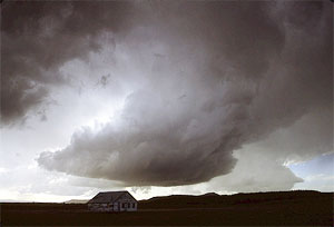
I was reading out loud as we drove down I-64 towards an ever darkening sky. My friend, Brad shushed me at one point to concentrate on driving. I looked up to see why and was stunned. A sheet of water and staccato pulses of hail and lightning were all I could see. It reminded me of the intensity of being caught in blizzard conditions while driving toward Tahoe in Northern California. But here we were, in Virginia on a very warm and balmy day and the sky had literally opened up with water. What's more, hail was falling. I turned to Brad and asked how could hail exist in such warm conditions? He was stumped and I was fascinated.
With a little detective work, I came up with an answer to the dilemma. Hail is only produced in cumulonimbi clouds (thunderclouds). They usually only occur at the front of a storm system which was what we experienced. The hail hit in the first ten minutes and then was followed by heavy rain. However, the rain was warm to the touch unlike the frozen water making up the hailstones.
The fire in the nearby Great Dismal Swamp National Wildlife Refuge and incredibly hot and humid conditions in Virginia created ideal conditions for hail. Hail is created inside a thunderstorm that has strong updrafts of warm air and downdrafts of cold air. A water droplet with an apex point is picked up by the updrafts and travels into the cooler air and freezes. The apex point known as the condensation nuclei in the water droplet was probably dust from the fire or nearby salt water during this particular hailstorm. (Both Brad and I experienced dry and stinging eyes after going into one of the storms later that weekend, much like the stinging of salt water.) Layers of ice are then accumulated around this nuclei as the droplet goes through a cycle of being caught in an updraft and then carried beyond the freezing level of the atmosphere and then thawing partially in entering the warmer air on a downdraft. This cycle repeats itself creating increasing layers of ice. Then as some point this frozen water droplet with several irregular layers falls to the ground as hail.
Some of the largest hailstones have been recorded during summer storms in humid climates because the warm updrafts and cold downdrafts along with high surface heat create an optimal cycle for large hail. Smaller hailstones can be coupled more easily with larger hailstones in these conditions.