upper waypoint

Postcards from Mars

Save ArticleSave Article
Failed to save article

Please try again

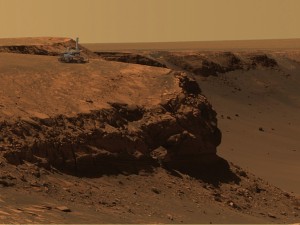
Picture of the edge of Victoria Crater superimposed with
image of the rover Opportunity.
Credit: NASA/JPL
Mars is not only on the horizon, it's become a sky-high creature of the night...and so, it's time to blog about the Red Planet once again, and to showcase a few favorite pictures from the veteran robots presently exploring that world.

Mars reaches "opposition" on December 24th. This is the time when Earth crosses directly between the Sun and Mars--in other words, when Mars is at the opposite end of the sky from the Sun and at its closest distance from Earth--this time about 55 million miles. You can see Mars yourself in the evening hours if you face east and look high: it's that steady, bright, orange dot right between Gemini and Taurus.

So what's been happening on Mars, exploration-wise? Here's a quick summary on that score:

NASA's Mars Exploration Rovers, Spirit and Opportunity, have had their tours of duty extended a fifth time, which should keep the rovers going--their health willing--possibly through 2009. Having landed on Mars in January of 2004 for a nominal 90 day mission, the robot pair has now lasted almost four years.

Spirit, which landed in the huge Gusev Crater, has traveled four and a half miles from its landing point and is now exploring a range of hills on a volcanic plateau. Probably topping the list of scientific evidence it has turned up is that water, in some form, has altered the chemistry in the environment, sometime in the past.

Sponsored

Opportunity, on the opposite side of the planet from Spirit, is currently exploring the half-mile-wide Victoria Crater. Exposed rock layers in the walls of the crater are expected to be an excellent "book" of Mars' geologic history for Opportunity's various instruments to read.

In its more than seven mile journey, Opportunity has revealed even stronger evidence that Mars' distant past may have been warmer and wetter, and that, at least in Opportunity's neck of the woods (Meridiani Planum), there may have been extended periods with liquid surface water.

The Mars Reconnaissance Orbiter spacecraft, with its array of instruments and super-powerful camera, has produced the most discerning orbital imagery of Mars' surface to date, giving us aerial views of the Martian deserts, canyons, ice caps, plateaus, volcanoes, craters, drainage channels, sand dunes, and so on, that look like they could have been taken from the window of a small airplane flying at very low altitude.

Even as Spirit and Opportunity send back postcard after postcard from the ground, like a pair of camera-happy tourists, that tantalize us with evidence of possible lakes, seas, and oceans in Mars' past, Mars Reconnaissance Orbiter with its more global viewpoint has revealed evidence that suggest another possibility: that the apparently periodic "bursts" of water activity might have been the work of large meteoroid impacts blasting through layers of ice and creating temporary episodes of water melt...

To round out the role-call, NASA's 2001 Mars Odyssey and Europe's Mars Express orbiters are also still in business and contributing to our already huge--but nowhere near complete--body of knowledge of that wandering orange dot in the sky...

Benjamin Burress is a staff astronomer at The Chabot Space & Science Center in Oakland, CA.

latitude: 37.8148, longitude: -122.178

37.7631 -122.409

lower waypoint
next waypoint