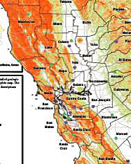
 Remember all those landslides in the area a couple of months ago? Well turns out there was a very good reason for them. Because there's a lot of landslides in the area.
Nothing like having a government map to confirm the on-the-muddy-ground facts. The California Geological Survey has released a first-of-its-kind survey of landslide potential for the entire state, and it shows California's coastal mountain region as thick with hazards. In our own neck of the woods, Marin, Santa Cruz are Sonoma as particularly treacherous. The map only takes into account the geological makeup of different areas, and not other factors such as rainfall or earthquakes.
One interesting part of this release is an additional map showing landslide susceptibility for the entire U.S. Scroll to the bottom here and you'll see how Northern California is second in high-intensity incidents to only West Virginia.