upper waypoint

Bay Area Storm Update: Storm Slackens, Leaves Mess Behind

Save ArticleSave Article
Failed to save article

Please try again

Street flooding on West Llagas Creek in Santa Clara County. (Peter Jon Shuler/KQED)

Update, 8:20 p.m. Sunday: Here's a bullet-point roundup of our not-quite-concluded Weekend of Storm. Our next regional weather concern is a storm forecast to roll into the region on Tuesday with the potential for more heavy rain over the already very thoroughly soaked North Bay counties.

Flood impacts: Minor flooding -- the kind that covers roads and farmland, but doesn't force wholesale evacuations or cause widespread damage -- occurred all over the Bay Area. Many roads around Sonoma County were affected, and U.S. 101 was closed for a time near Windsor. Rapid rises on the Napa River caused limited local flooding in part of the valley north of the city of Napa. Flooded roads at the northern end of the valley prompted the Calistoga school district to cancel classes Monday.

Perhaps the biggest concern going into Monday are conditions along the lower Russian River. With the river expected to crest several feet above flood stage by midday Monday, Sonoma County officials issued a voluntary evacuation advisory for those living in low-lying sections of Guerneville and Monte Rio.

Travel impacts: Slides and falling trees shut down both main highways and rural roads throughout the Bay Area and Northern California on Sunday, and some closures could last for days. One notable example on the Peninsula was this one, on Interstate 280:

Sponsored

Full or partial closures were also recorded on: Highway 17, the main route between San Jose and Santa Cruz, because of a fallen tree near the Highway 35 junction; westbound Interstate 80 near Truckee, due to a mudslide; eastbound I-80 near Colfax, due to downed power lines; Highway 49 near Nevada City and Downieville, due to slides; Highway 20 near the Interstate 80 junction, because of flooding (slide). (For more, see Caltrans Road Conditions lookup.)

Power impacts: Sunday night, PG&E said 478,000 customers systemwide had lost power during the course of the windy deluge, and 66,000 were still without electricity. In the Bay Area, a total of 240,000 customers lost power at some point during Stormy Sunday, with about 17,000 still in the dark late in the evening.

Precipitation totals: One catches a slight hint of "really -- that was a monster storm?" in some of the online commentary about the weekend's storm. True -- it was not a cataclysm, and it didn't deliver all of the gaudy precipitation totals we have been talking about. But it wasn't a meteorological wimpfest either. Some rain numbers for the 48 hours ending at 7 p.m. Sunday:

Venado (western Sonoma County):
12.31 inches
Mount Umunhum (Santa Cruz Mountains): 8.67 inches
Ben Lomond (Santa Cruz Mountains): 7.00 inches
Mount Tamalpais: 4.93 inches
Mount Diablo: 3.97 inches
Vollmer Peak (Berkeley Hills): 3.56 inches

Urban totals include:

San Rafael: 4.80 inches
Los Gatos: 3.71 inches
Santa Rosa: 3.52 inches
St. Mary's College (Moraga): 3.22 inches
Sacramento: 3.17 inches
Richmond: 2.63 inches
San Francisco: 2.03 inches
Concord: 1.89 inches
Oakland: 1.83 inches
Livermore: 1.50 inches
San Jose Airport: 1.28 inches

Update, 4:50 p.m. Sunday: Well, we here at the Berkeley headquarters of KQED's Storm Center 2017 are in full catch-up mode for the time being. Here's our Storify rounding up social media and online news reports of the storm's impact this afternoon (and see our earlier updates below).

[http_redir]


Update, 2 p.m. Sunday: Two major themes for the storm in the Bay Area so far:

Theme 1: Lots of local roadway flooding and rising streams -- not surprising given the downpours we see falling on saturated soil all across the region. Take a look at the Napa Valley, for instance:

The flooding seems particularly acute in Sonoma County. Here's an example (and public service announcement) posted by the San Francisco Chronicle's Demian Bulwa:

The good news for the North Bay is that the worst of the storm appears to have abated. Periods of rain will continue into Monday -- but not serious, sustained intense rain. Meantime, the main focus of the storm has shifted south, where flooding concerns continue in parts of southern/eastern Santa Clara County.

Theme 2: Lots of power outages, with PG&E reporting more than 100,000 customers without power in its service area as of early Sunday afternoon. A quick tally of the hundreds of outages the company is reporting shows more than 40,000 Bay Area customers without electricity.

According to PG&E, Bay Area communities with 1,000 or more customers currently suffering outages early Sunday afternoon include:

Antioch: 4,934
Bodega Bay: 1,746
Daly City: 4,060
El Granada: 2,033
Guerneville: 1,249
Larkspur: 2,935
Orinda: 1,870
San Bruno: 1,175
San Francisco: 5,401
San Geronimo: 2,684
San Jose: 6,557
Sebastopol: 2,981

Major outages outside the Bay Area include about 7,000 customers in the communities of Pine Grove and Pioneer in Amador County, about 3,500 customers in Twain Harte (Sonora County) and 2,500 in the town of Mendocino.

Original post, 7:55 a.m. Sunday: The big storm forecasters have told us for days we could expect this weekend swept across the Bay Area late Saturday night and was causing a mess by early Sunday.

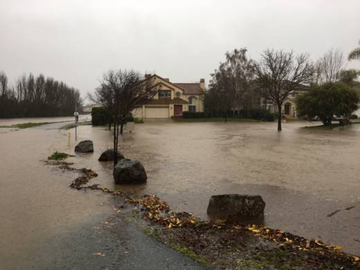
The main area of concern at daybreak is southern and central Sonoma County. The National Weather Service issued a flash flood warning for Santa Rosa and nearby communities.

The Sonoma County Sheriff's Office reported that U.S. 101 was closed in both directions at Windsor, just north of Santa Rosa, and that at least two motorists were rescued from vehicles near Old Redwood Highway and Eastside Road, on Windsor's northern end.

Waters rose in the North Bay as the dense plume of moisture feeding the storm swung north through the region overnight. After something of a break in the deluge for some areas Sunday morning, the heaviest rain is expected to swing south again before finally tapering off late in the evening.

PG&E reported dozens of power outages throughout Northern California affecting tens of thousands of customers, including 21,000 in the Bay Area.

The most extensive Bay Area outage early Sunday appeared to be in Daly City and adjacent areas of San Francisco, where nearly 6,000 customers were reported without power.

Other notes from the nine-county Bay Area:

  • The California-Nevada River Forecast Center says the Napa River will crest above flood stage in St. Helena and just at flood stage in the city of Napa later Sunday.
  • The Guadalupe River is also expected to reach flood stage in San Jose Sunday afternoon.
  • The Russian River is expected to reach flood stage early Monday morning and crest later in the day with some inundation forecast in Guerneville.

As far as rainfall is concerned, the National Weather Service commented in its early morning forecast discussion that overnight rainfall totals are somewhat less than expected. The highest 12-hour rain totals through 7 a.m. Sunday are mostly where we'd expect, in the northwest Sonoma County hills (4.60 inches at Venado) and Santa Cruz Mountains (2.53 inches at Ben Lomond).

Sponsored

For more data, see the river forecast center's rainfall map.

lower waypoint
next waypoint
Stunning Archival Photos of the 1906 Earthquake and FireWhy Nearly 50 California Hospitals Were Forced to End Maternity Ward ServicesDemocrats Again Vote Down California Ban on Unhoused EncampmentsFederal Bureau of Prisons Challenges Judge’s Order Delaying Inmate Transfers from FCI DublinFirst Trump Criminal Trial Underway in New YorkSan Francisco Sues Oakland Over Plan to Change Airport NameJail Deaths Prompt Calls To Separate Coroner And Sheriff's Departments In Riverside CountyDespite Progress, Black Californians Still Face Major Challenges In Closing Equality GapThe Beauty in Finding ‘Other People’s Words’ in Your OwnRichmond Passes 45-Day Retail Moratorium on Tobacco to Deal With 'Excessive Smoke Shops'