The two maps (above and here) incorporate changes proposed on the other maps and the most frequently heard suggestions at the half a dozen city meetings held on redistricting since early summer. Both were drawn by the City’s consultant, National Demographics Corp., which describes them as “attempts to put the many different comments and requests together into a plan that draws on the public input and balances the competing nature of some of the requests.”
Both, for instance, put the Maxwell Park neighborhood in one district, rather than having it split among three the way it is now. They also take a sliver on the east side of Lake Merritt that for some reason was grouped with West Oakland in District 3 and put it with contiguous areas instead in District 2 which includes Chinatown. They also move part of the San Antonio neighborhood from District 2 and put it in 5, to keep the populations of each district almost the same, and have compact districts.
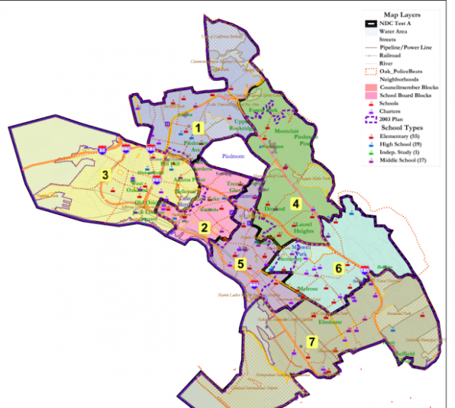
Map #17
“This map is taking a lot of different ideas from different people,” said the NDC consultant for Oakland, Douglas Johnson.
The main thing it does is bring the Maxwell Park neighborhood into one district, 6, instead of splitting this tight-knit group of residents into three districts, as is the case currently. Johnson said it makes District 4 more cohesive by not having it “wander into the hills.” More details are here.
Map #18
Map #18 puts Maxwell Park in District 4, again bringing it all into one district, just a different one, and then it adjusts Districts 5 and 6 to balance the population changes resulting from Maxwell Park being combined into District 4, according to the consultant. It also restores Broadway Terrace as the boundary between Districts 1 and 4, which was the case before the last redistricting in 2003.
But what neither map does is significantly change Oakland’s districts from what they currently are, despite many calls for creating districts that would be socio-economically “cohesive” so that people with like concerns, such as relying on transit, could have a representative rather than someone who needs to represent both transit riders and those who have cars, those needing food assistance and those who don’t.
In the months since June when the City first announced it would do redistricting this year, the 10th year since the last time redistricting occurred, a number of people have proposed that redistricting allow flatland neighborhoods of East Oakland more voice in City and school district affairs by drawing districts that are socio-economically cohesive rather than including districts that have both very low-income areas and very high-income areas of the Oakland Hills. Some proposed maps did that.
But when the City Council Rules and Legislation Committee met October 3, Council members Libby Schaaf of District 4 and Pat Kernighan of District 2 said they heard from their constituents that they did not want a dramatic change in districts.
“It was an interesting debate this year. Oakland is always struggling with how we represent all parts of our city. I heard great arguments on all sides and a campaign to align districts in more socio-economic clusters,” Councilwoman Schaaf said at the meeting.
“When I went out to my constituents, I did not find an appetite for that. I found more fear of dramatic changes. So from what I am hearing and feeling, I would recommend focusing our discussion on maps with less significant changes.”
Steve Spiker, the technology director of the Urban Strategies Council, said the two maps the Rules Committee decided to put before the full Council do not address the socio-economic clout issue. “Neither seem to have taken the blank canvas approach, more like considering the current lines and looking at subtle tweaks to accommodate just some of the community feedback. Given this was a chance at a whole rethink, these two proposed maps are disappointing.”
From his reading, Map #17 expands District 4 (Montclair) further below MacArthur Boulevard, but it reunifies most of Maxwell Park into District 6. It removes part of San Antonio from District 2. “I’’ve heard neighborhood concerns about that.” Map # 18, he said, also reunifies Maxwell Park but places it in District 4 (Montclair). “The resulting District 6 does not appear to meet compactness and contiguity requirements: it is not compact! District 2 has the same issues for San Antonio as in map #17,” he said in an email.
Tuesday night is a chance for the public to speak about the two maps.
Here's earlier coverage at "Oakland's Low-Income Communities Look to Gain Power Through Redistricting."