upper waypoint

Map Shows Spread of Rim Fire Day by Day

Save ArticleSave Article
Failed to save article

Please try again

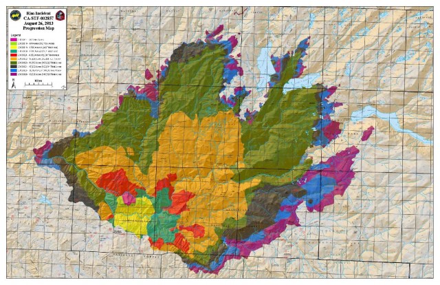
Here's a very good map from InciWeb showing the spread of the Rim Fire day by day, from Aug 17 to yesterday, Aug 26. As you can see, the rate of growth has slowed considerably. AP reports this morning that the fire is 20 percent contained, up from 15 percent on Monday. Officials said the fire has grown to about 280 square miles, up from about 252 square miles the previous day, but back burning by crews was responsible for at least part of that increase. The fire is currently the seventh largest in state history, having consumed more than 179,000 acres.

Click on the map for a larger image. More updates on the fire from InciWeb here.

inciwebfiremap

Sponsored

lower waypoint
next waypoint
State Prisons Offset New Inmate Wage Hikes by Cutting Hours for Some WorkersCecil Williams, Legendary Pastor of Glide Church, Dies at 94Erik Aadahl on the Power of Sound in FilmFresno's Chinatown Neighborhood To See Big Changes From High Speed RailKQED Youth Takeover: How Can San Jose Schools Create Safer Campuses?How to Attend a Rally Safely in the Bay Area: Your Rights, Protections and the PoliceWill Less Homework Stress Make California Students Happier?Rainn Wilson from ‘The Office’ on Why We Need a Spiritual RevolutionNurses Warn Patient Safety at Risk as AI Use Spreads in Health CareSilicon Valley House Seat Race Gets a Recount