In large part this is a project that goes back many years through multiple permutations of task forces and projects under several different mayors.
There have been people who are concerned that no single agency is responsible for Ocean Beach. The belief is that too many agencies are responsible for too many things and they don't always talk to each other or pull in the same direction.
So a lot of people who care about Ocean Beach have been trying to get everyone on the same page and create a way forward, something everyone can live with even if they don't get everything they want.
Explain what agencies are involved with Ocean Beach.
The beach itself is part of Golden Gate National Recreation Area (GGNRA), from the O'Shaughnessy Seawall in the north, opposite the beach chalet that you walk up to to get to the Cliff House. Everything to the west, the sand side, is GGNRA, down to the wet sand of the beach. On the other side of that seawall is the parking, which is city property. So the city manages and is responsible for the parking lot, but if you go down those steps, you're on federal property. Those are the two main agencies.
The CPUC has a great deal of infrastructure that is at or near the beach. There's a major sewage transport tunnel that lies under the Great Highway, which feeds the oceanside water pollution control plant at the south end of Ocean Beach. That's city property that is operated by the SF Public Utilities Commission, but the responsibility for maintaining infrastructure like the road and the oceanside water pollution control plant is all done by the SF Dept of Public Works.
In addition there are responsibilities that overlap. The state Dept of Fish and Game, for instance, enforces fishing regulations.
What are some concerns being addressed in the Master Plan?
One of the big challenges Ocean Beach is facing is what will happen if sea levels rise, as it appears they're going to do. We're seeing some erosion, especially on the south end of Ocean Beach, that could be attributable simply to singular storms. Those have caused some major problems, including the closure for several months of the southern extension of the Great Highway.
But in addition to those singular events, there is the likelihood that the sea level is going to rise, and when we get large storm surges, they're going to have a greater impact than they have now. So the question is what is the impact going to be on the beach? Are we going to have a nice sandy beach, or in order to protect some of these things like the Great Highway and the sewer transport tunnel and the water pollution control plant, are we going to have to install large seawalls or something like that?
Does the plan put forward some suggestions on this?
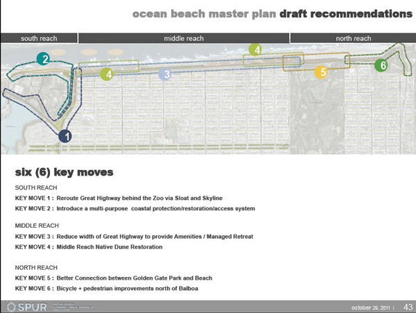
It does. One of the important ideas presented under the draft recommendation for the Ocean Beach master plan would be to reroute that southern extension of the Great Highway that was closed, around the backside of the zoo so that it no longer passes to the west of the water pollution plant, but instead goes around the other side and connects with Sloat Boulevard. So southbound traffic on the Great Highway would no longer go past Sloat and around the water plant to Skyway Blvd around Lake Merced, but instead would turn east on Sloat and meet up with Lake Merced Boulevard to west of the zoo. (Interview continues after the graphic.)

These are big infrastructure suggestions. How do people feel in the neighborhoods around there feel about them?
That's a really good question. I think in spite of the fact that potentially there will be some major changes, a lot of people aren't paying a lot of attention to the plan, or if they are it's not coming through in terms of the voicing of opinions. That in part is due to the scope and scale of the Ocean Beach Master Plan. It's so large, it encompasses the beach from north to south and it plans for several decades, so it's hard for people to get their minds around .
But I have heard from some readers who are concerned about the Great Highway in particular. I got email from a reader who wondered that if there's ever a need for emergency transportation out of SF, where are the residents of Richmond and Sunset going to go? How do they get out of the city if they're not going north over the Golden Gate Bridge or east across the city? If they need to go south, how do they get there? The surface roads we have there are not designed to handle a great pulse of traffic like that. The Great Highway is in this reader's opinion a necessary artery out of the city for those residents.
But one of the questions is: can we maintain the Great Highway there no matter what we do? Is the ocean going to make a decision for us if we don't make one through the master plan now?
It seems like the sand dunes already make a decision about that with great regularity...
Exactly. The Great Highway is closed frequently for the removal of sand. One thing I often hear out here is people questioning the wisdom of creating a highway out here in the first place. At the time it was built, this part of the city was largely sand dunes still. I find a lot of people in particular are perplexed that anyone would think to build a four-lane road on top of sand dunes. They are not surprised when the road is overtopped by blowing sand or it's closed when too much sand is on the road. They kind of shake their head and wonder why the road is there in the first place…
SPUR's plan kind of acknowledges that and moves the traffic from the Great Highway southbound lanes and puts two lanes, bidirectional traffic, on the east side of those, where we have northbound lanes now. it acknowledges we have a lot of blowing sand, and that we need to blunt the impact of major storm events.
So what is SPUR's function?
SPUR is a convener and a coordinator for the master plan. The reason they're there, according to SPUR, is that they have a lot of contacts in the agencies. They know the players already, work with city agencies, and they are a non-partisan organization. They do advocate for some things but they're not an interested party in Ocean Beach directly.
What are next steps?
SPUR is in the process of gathering public input on their draft proposals. They are going to take that public input into account to see if they are on the right track. They will come back with a revision later on, with the goal of having a completed plan in Feb, 2012.
How can people give feedback to SPUR?
The email is oceanbeach@spur.org.
Anything else?
It's important to note that when SPUR first started this process, they expected to have one plan addressing changes to 2050. Now they've taken in a suggestion from the Surf Rider foundation – which has its own plan for addressing Ocean Beach. So they will still plan to 2050 but make a reassessment around 2030.

