upper waypoint

Early Bay Area Heat Wave Brings Hottest Temperatures of the Year So Far

Save ArticleSave Article
Failed to save article

Please try again

The sun sets over San Francisco International Airport on May 8, 2024, ahead of a two-day heat wave in the Bay Area. (Tayfun Coskun/Anadolu via Getty Images)

Crowds in San Francisco enjoyed a taste of summertime weather on Thursday as the Bay Area saw its hottest day since last fall amid a regionwide warming trend, days after an unusually strong spring storm.

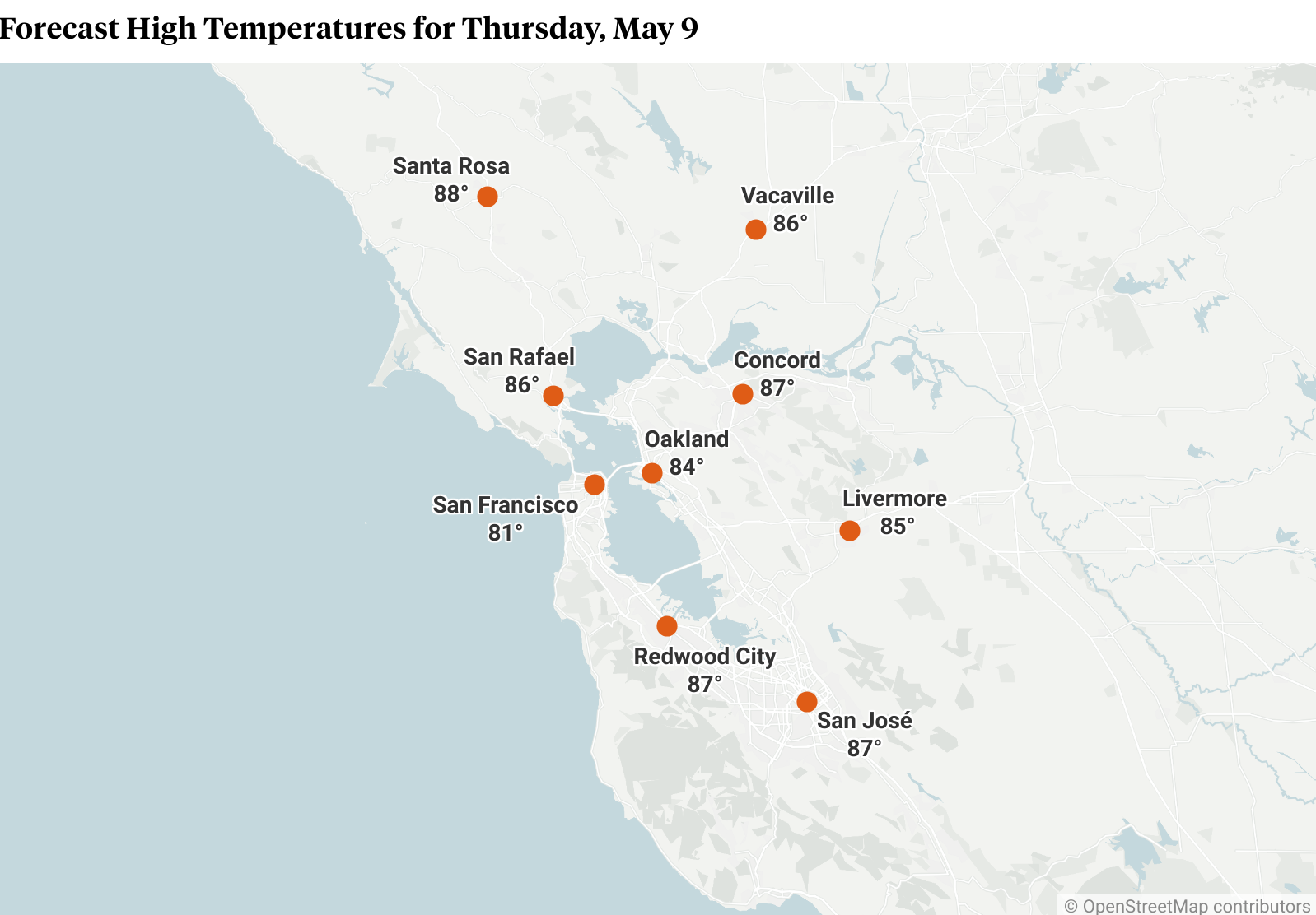
By 2 p.m., temperatures reached 78 degrees in downtown San Francisco, 82 in Oakland, 82 in San José and 84 in Santa Rosa, according to the National Weather Service. However, forecasters said areas throughout the Bay Area could continue to warm up 3 to 5 degrees throughout the afternoon.

On Thursday morning, some North Bay weather stations were showing temperatures at least 20 degrees higher than they were the previous morning, the NWS Bay Area office posted on X.

“It’s definitely above seasonal averages,” said Matt Mehle, a meteorologist with the NWS Bay Area office in Monterey. “Normal temperature this time of year [for the North Bay] is low 70s, and we’re forecasting a high of 89 today.”

Even throughout San Francisco and other cities in the heart of the Bay Area, Mehle said, temperatures were expected to be in the ballpark of 10 to 15 degrees above normal.

That warm weather drove people out to San Francisco’s Dolores Park en masse. All of the park’s tennis courts were full, laughter radiated from the children’s play area and sunbathers in various states of undress lined the park’s northern hill.

A map showing high temperatures in different Bay Area cities
Source: National Weather Service (Matthew Green/KQED)

Jettiene Legault was flying a kite while chatting with friends.

“I feel very good about the weather today,” Legault said. “It’s nice to get out and enjoy the sun. I’m here with my friends. We’re having a picnic, and then we’re going to go to the beach later.”

Others at the park had no greater ambition for the day than to bask in the sun’s warmth.

Terrence Lee, who was out with a few coworkers, explained his plans simply.

“We’re primarily lying flat, and we’re gossiping… I think that’s all on the agenda,” Lee said.

Naame Kelet said she had been lying in the sun for hours when she spoke to KQED near noon.

Sponsored

“I woke up super early. I had a bunch of things planned, but I really wanted to save part of my day just to come out here and enjoy the sun,” Kelet said.

Kelet, a lifelong Bay Area resident, was thrilled about the sunny day but also wary of San Francisco’s reputation for having a few warm spring days that give way to falling temperatures and fog.

“I’m just hoping it stays consistently warm, but I’m not putting all of my eggs in that basket,” she said.

more weather coverage

The significant warming trend is being driven by high pressure and offshore flow, which is a weather feature normally seen in the fall, with warm, dry wind coming from the north and northeast, said Mehle, the NWS meteorologist.

That offshore flow led to some wind advisories early Thursday, with morning gusts of 45 to 55 mph expected in the Mayacamas Mountains, north of Santa Rosa. Although no advisory was issued for the East Bay Hills, Mount Diablo was also expected to see gusts of 40 to 50 mph on Thursday morning.

The heat and wind are not expected to significantly increase fire danger, though, thanks in large part to recent precipitation, including last weekend’s rainstorm, Mehle said.

“We’re actually in pretty good shape from that standpoint. We are seeing wetter than normal fuels around the Bay Area due to our wet spring,” he said. “These late-season rain events that we’re getting are helping to mitigate fire concerns.”

The NWS did not issue a red-flag warning, and state and local fire officials said they were not on high alert.

Conditions in the Bay Area will continue to heat up on Friday, which is expected to be the warmest day of the week, particularly in inland areas. Some parts of the North Bay and East Bay could approach 90 degrees.

Temperatures will start to dip on Saturday with increased onshore flow, according to the NWS forecast. However, another ridge of high pressure approaching the West Coast should keep the mercury above seasonal averages, with interior areas remaining 5 to 15 degrees above average into early next week.

That ridge will drive higher temperatures by next Tuesday or Wednesday, Mehle said, but “not as warm as what we’re seeing today or tomorrow.”

lower waypoint
next waypoint
Federal Judge Orders New Sentencing Hearing for David DePape in Trial Over Pelosi AttackSome Bay Area Universities Reach Deal to End Encampments, but Students Say Their Fight ContinuesAfter Months-Long Coma, This Latino Immigrant Worker Is Still Fighting Mysterious Long COVID SymptomsEighth-Grader's Call to 911 About Teacher's Outburst Causes StirCalifornia Promised Health Care Workers a Higher Minimum Wage — but Will Newsom Delay It?David DePape Sentenced to 30 Years in Federal Prison for Attack on Nancy Pelosi's HusbandFree Key Choir: 'What's in a Name'Newsom Says California Water Tunnel Will Cost $20 Billion. Officials and Experts Say It's Worth ItAntisemitism Is on the Rise, but Defining It Is Harder Than Condemning ItImpact of California Fast Food Worker Wage Increase Still Too Early to Gauge