upper waypoint

Bay Area Weekend Weather: Latest Round of Winter Storms Expected to Continue Into Monday

Save ArticleSave Article
Failed to save article

Please try again

An aerial view of flooded farmland and farm houses.
In an aerial view, floodwaters cover an agricultural area after the Salinas River overflowed its banks on Jan. 13, 2023 in Salinas, Monterey County. Several atmospheric river events continue to pound California with record rainfall and high winds. (Justin Sullivan/Getty Images)

This story will no longer be updated.

Updated, 12 p.m. Sunday: More rain and snow fell during the weekend in storm-battered California, making travel dangerous and prompting new evacuation orders over flooding concerns along a swollen river near Sacramento.

Bands of thunderstorms with gusty winds started Saturday in the north and spread south, with yet another atmospheric river storm following close behind Sunday, the National Weather Service said.

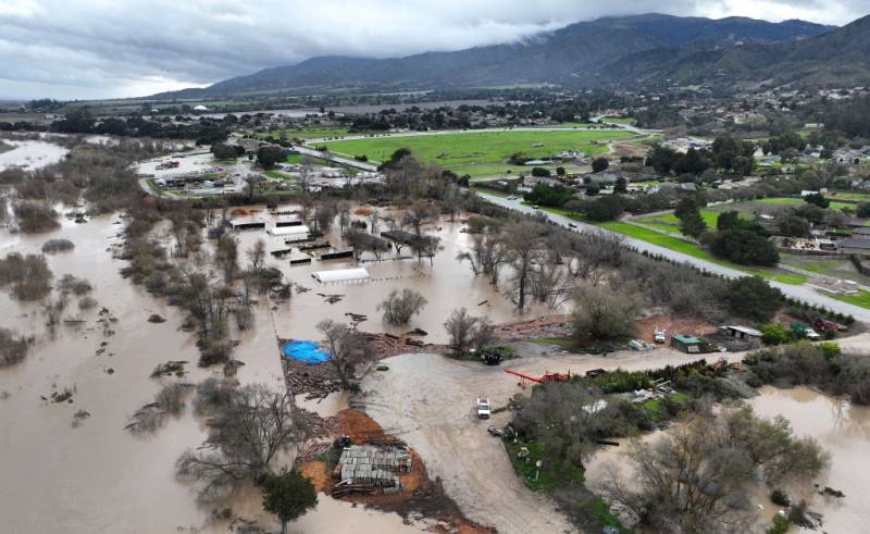
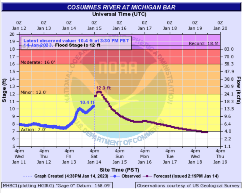
Up to 2 inches of rain was predicted for the saturated Sacramento Valley, where residents of semi-rural Wilton, home to about 5,000 people, were ordered to evacuate as the Cosumnes River continued to rise.

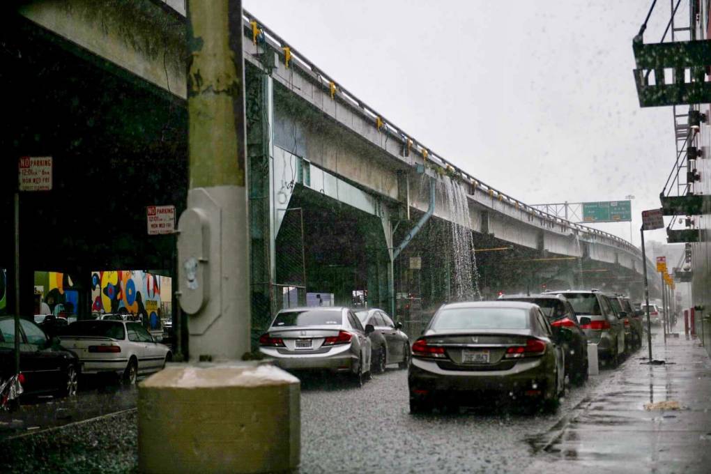
Another 3 inches of snow and gusty winds were expected in the Sierra Nevada. Interstate 80, a key highway from the San Francisco Bay Area to Lake Tahoe ski resorts, reopened after being closed most of Saturday because of slick roads, snow and whiteout conditions.

The University of California Berkeley Central Sierra Snow Lab tweeted Sunday morning that it received 21.5 inches of snow in 24 hours. Its snowpack of about 10 feet was expected to grow several more feet by Monday.

A backcountry avalanche warning was issued for the central Sierra, including the greater Lake Tahoe area, through Monday.

The California Highway Patrol rescued three people whose car slid off a rain-slicked road and ended up teetering at the edge of a cliff in the Santa Cruz Mountains on Friday. The occupants of the car “were scared for their lives and were in disbelief” when they were pulled safely from the car as the vehicle's front end hung precariously over the cliff's edge, the highway patrol said in a statement.

“We cannot stress this enough. Please ONLY drive if it’s necessary,” the statement said.

Just to the south in Santa Cruz County, the tiny community of Felton Grove along the San Lorenzo River was under an evacuation warning.

The swollen Salinas River swamped farmland in Monterey County. To the east, flood warnings were in effect for Merced County in the agricultural Central Valley, where Gov. Gavin Newsom visited Saturday to take stock of problems and warn of still more possible danger.

“We're not done,” Newsom said. He urged people to be vigilant about safety for a few more days, when the last of a parade of nine atmospheric rivers was expected to move through.

In Southern California, winter storm warnings and advisories were in place for mountain areas, where many roads remained impassable because of mud and rock slides. Two northbound lanes of Interstate 5 near Castaic in northern Los Angeles County were closed indefinitely after a hillside collapsed.

The series of storms has dumped rain and snow on California since late December, cutting power to thousands, swamping roads, unleashing debris flows, and triggering landslides.

President Joe Biden declared a major disaster in the state and ordered federal aid to supplement local recovery efforts in affected areas.

At least 19 storm-related deaths have occurred, and a 5-year-old boy remained missing after being swept out of his mother’s car by floodwaters in San Luis Obispo County.

Dry days are in this week’s forecast for California starting on Tuesday.

Updated, 6:30 p.m. Saturday: Sacramento County's Office of Emergency Services has issued an evacuation order for the Wilton Area due to an anticipated rise in the Cosumnes River ​levels. The evacuation orders are an upgrade from the warning earlier and will be in effect from 4:32 p.m. Saturday to 4:32 a.m. Sunday. Areas impacted are within the area of Highway 16 and Grantline West to Highway 99, South to Valensin, and North East to Dillard and Highway 16.

A flood chart showing potential flooding.

An evacuation shelter is located at the Chabolla Center, 600 Chabolla Avenue, Galt, CA 95632. Call 211 for additional information. Report flooded roads by calling 311.

As of 3 p.m. Saturday, PG&E had 5,258 customers without power in the nine Bay Area counties, with another 5,326 customers without power in Santa Cruz County. For more information, see PG&E's power outage map.

Updated, 3:30 p.m. Saturday: The National Weather Service issued a flood watch and wind advisory for the Bay Area that runs from 3 a.m. Saturday through 9 a.m. Monday.

Locations prone to tidal flooding in coastal areas will likely see coastal flooding caused by a combination of high tidal cycles, onshore winds, heavy runoff and continued rainfall, the weather service said.

More evacuation orders were issued in Santa Cruz County today, for the low-lying areas of Corralitos or Salsipuedes Creeks (PDF), the Rio Del Mar Esplanade, and the low-lying residences along Soquel Wharf Road, Soquel Village and 3060 Porter Street. County officials also said evacuations were underway in Holohan/East Lake/College, PAJ-E015, E024, E026, E027, E028.

The San Lorenzo River rose rapidly today, reaching major flooding stage by midday before dropping back to moderate flooding stage by 3 p.m. Emergency evacuations were underway in Felton Grove in Santa Cruz County as water levels rise, county officials said Saturday morning. Shelter sites at Cabrillo College and the Santa Cruz County Fairgrounds remain open, county officials said.

In Monterey County, evacuation orders have been issued for low-lying areas of Carmel River, the Monterey County Sheriff's Office said Saturday in an alert sent out at 1 p.m. The order includes the Carmel River north of Klondike Canyon Road/Carmel Valley Road and south of Rancho San Carlos Road. The order upgraded evacuation warnings to evacuation orders.

Evacuation warnings for areas near Las Lomas were also effective immediately until further notice due to the storm, county officials said just after noon Saturday.

U.S. Highway 1 is closed in Point Reyes between Mesa and Cypress roads, Marin County officials said Saturday morning. PG&E is responding due to power lines that went down, officials said on social media. The closure is expected to last for most of the day. About 851 PG&E customers are affected by the outage, according to officials, who added that residents and the traveling public should avoid the area.

Updated, 2 p.m. Saturday: Storm-battered California got more wind, rain and snow today, raising flooding concerns, causing power outages and making travel dangerous.

Bands of rain with gusty winds started in the north and spread south, with more storms expected to follow into early next week, the National Weather Service said, adding "lighter rainfall could continue Sunday with another ramp-up late Sunday into early Monday ahead of a second system."

More than 68,000 utility customers were without electricity by late morning, according to poweroutage.us.

Flood warnings were issued for the region north of San Francisco Bay, including Napa, Sonoma, Mendocino and Marin counties.

A landslide in Fairfax, Marin County, damaged six apartments and displaced 19 residents as the county continued to grapple with the effects of a drenching month, reported the Marin Independent Journal on Friday.

The slide happened at a complex on Olema Road, sending mud and debris at the residences and in some spots breaking through walls, doors and windows, said Marin County Fire Department Chief Jason Weber in an interview with Marin Independent Journal reporter Alex N. Gecan. No injuries were reported.

“Due to the fact that our soils are completely saturated, we’re going to see quite a bit of land movement around the county,” Weber said. “Those that live on or around hillsides need to be cognizant of this, and make sure that their drainage is working.”

To the south, warnings were posted for parts of counties including San Mateo and Santa Cruz, where the tiny community of Felton Grove along the San Lorenzo River was ordered evacuated.

The county of Santa Cruz on Friday formally requested state and federal assistance (PDF) through the California Disaster Assistance Act on behalf of the region "to assist with losses and emergency repairs as a result of damages cause by the atmospheric winter storms which began on December 30, 2022."

The swollen Salinas River swamped farmland in Monterey County, and to the east, flood warnings were in effect for the San Joaquin Valley community of Merced.

Slick roads, snow and whiteout conditions plagued highways through the Sierra Nevada.

The UC Berkeley Central Sierra Snow Lab tweeted Saturday morning that it received 21.3 inches of snow in 24 hours and that its snowpack of about 10 feet was expected to grow several more feet by Monday.

A backcountry avalanche warning was issued for the central Sierra, including the greater Lake Tahoe area.

Original story, 5:30 p.m. Friday: California will see another round of stormy weather through the weekend and into next week, in an unwelcome continuation of the atmospheric river pattern that has been soaking the state for the last two weeks.

After a brief respite of dry weather on Thursday, rain — heavy at times — returned to the Bay Area Friday morning, with the possibility of more thunderstorms Friday afternoon and into the evening, particularly in the North Bay, according to the National Weather Service.

Forecasters say a new, similar cold front is likely to bring more intense rain Saturday morning, raising a new round of flood concerns.

A wind advisory has also been issued for the Bay Area for Saturday, from 4 a.m. to noon, with possible gusts of up to 50 mph possible in higher elevations.

As a result, falling debris, downed power lines and downed trees are once again expected to threaten human life throughout the storm's duration.

After a brief lull Sunday morning, yet another storm system, this time a warm front, is expected to reach the region by Sunday afternoon, with lighter but more consistent rain expected through Monday, said Eleanor Dhuyvetter, a meteorologist with the National Weather Service based in Monterey.

"We know especially with the [49ers] playoff game tomorrow, people might be out and about, so do make sure to be aware of flash-flood warnings and especially be cautious with driving," she said. "We've seen videos of a lot of potholes and sinkholes, which do creep up in areas that have had a lot of water ... and that's a lot of areas right now."

The new wave of precipitation prompted the NWS to issue a new flood watch Friday for the entire Bay Area and Central Coast, remaining in effect through Monday afternoon.

The North Bay and Santa Cruz and Monterey counties face the highest risk of flooding, high winds and high surf with waves of 20 to 25 feet during the storm, according to the weather service, as both areas are forecasted to receive between 4 and 6 inches of rain along the coast and at higher elevations.

"We are not out of the woods yet," Nancy Ward, director of the Governor's Office of Emergency Services, said during a Friday media briefing. "People will become complacent, but the ground is saturated. It is extremely, extremely dangerous."

"The threat to communities remains and waters will continue to rise even after these storms have passed," Ward added. She said that the state is still gathering information from local governments about damage suffered so far in the recent storms, but estimated that the price tag for recovery could top $1 billion.
.
Deanne Criswell, chief of the Federal Emergency Management Agency, said during Friday's briefing that the Biden administration is still reviewing a request from Gov. Gavin Newsom to declare the storms a major disaster, a step that would clear the way for increased federal aid to the state.

In Sonoma County, guidance from the California-Nevada River Forecast Center suggests the Russian River at Guerneville will crest late Sunday morning 1.5 feet above flood level. Nearby streams, including Mark West Creek east of Guerneville, are also at flood level.

Flood warnings were also in effect Friday for the Salinas River, near the city of Salinas, in Monterey County, about 90 miles south of San Francisco. Drone footage from late Thursday shows a levee breaking and the river beginning to overflow its banks. Dhuyvetter said the river remains in a "minor flood stage" and is expected to crest later on Friday, before midnight, then come back down. She said she could not comment on which specific levees might have failed.

Flood concerns also continue along Bear Creek, a tributary of the Merced River that flooded earlier this week and inundated the town of Planada.

At least 20,000 acres of farmland in the Salinas Valley, the so-called "salad bowl of the world," were at risk of flooding, according to NWS reports. As of Friday, some 6,000 people were under evacuation orders throughout California, said Ward.

According to Monterey County's Department of Emergency Management and the county Sheriff's Office, flooding is expected on state Highway 68, River Road, Reservation Road, Blanco Road, several secondary roads and possibly state Highway 1.

Evacuation orders are already in effect for low-lying areas along the Salinas River from north of Highway 68 to the coast. Evacuation order information for Monterey County can be found here.

Power outages continue to roil the region due to downed trees and power lines caused by high winds, which have reached hurricane strength in some parts of the state. On Friday, 20,000 households were without power, said Ward.

Since late December, California has been drenched by a relentless string of "atmospheric river" storms, with the normally drought-plagued state averaging more than 9 inches of rainfall a day over the last 18 days — a remarkable amount that has seen some locations meet their average annual rainfall already, said David Lawrence, meteorologist with the National Weather Service.

The storms have also spurred an onslaught of flooding, fallen trees, power outages and debris flows, and resulted in at least 19 storm-related deaths. Half of those have involved motorists, with some of the deaths preventable if drivers had heeded road closure signs, said Sean Duryee, acting commissioner of the California Highway Patrol.

With more rain and snow predicted through the weekend and into next week, the state's Office of Emergency Services said it was preparing resources, including swift-water rescue teams and firefighting personnel, across eight counties in Central and Northern California.

This story includes reporting from KQED's Dan Brekke and Emma Silvers, The Associated Press and Bay City News.

Sponsored

Sponsored

lower waypoint
next waypoint
California Law Letting Property Owners Split Lots to Build New Homes Is 'Unconstitutional,' Judge RulesAlameda: The Island That Almost Wasn’tJust Days Left to Apply for California Program That Helps Pay for Your First HouseIn Fresno’s Chinatown, High-Speed Rail Sparks Hope and Debate Within ResidentsNPR's Sarah McCammon on Leaving the Evangelical ChurchUC Regent John Pérez on the Gaza Protests Roiling College CampusesIs California Headed For Another Tax Revolt?KQED Youth Takeover: We’re Getting a WNBA TeamSan José Adding Hundreds of License Plate Readers Amid Privacy and Efficacy ConcernsUSC Cancels Main Graduation Ceremony Amid Ongoing Gaza Protests