The Bay Area water system is a byzantine patchwork of agencies — more than 50 in all — that provides water to customers. Some are the ones you see on your water bill. Others are middlemen that provide water to local agencies at the wholesale level.
And some of that water makes a long journey. Southern California has the reputation for tapping far-flung sources for its water needs, but the Bay Area is in the same boat.
More than two-thirds of the Bay Area’s water supply comes from outside the region, which means in extreme drought years, local water districts are competing with many others around the state for limited supplies.
Sponsored
As we suffer under another dry period, some parts of the Bay Area are experiencing the drought more acutely because of where they get their water. We’re going to break it down for you.
Bay Area Water Districts By Major Source of Supply
The system originates more than 100 miles from its primary customers, in Yosemite National Park. O’Shaughnessy Dam was built on the Tuolumne River in 1923 to create Hetch Hetchy Reservoir. The water travels through a series of pipelines before it reaches the Bay Area and blends with five local reservoirs. The Tuolumne River joins the San Joaquin River and flows into the Delta.
San Francisco depends on Hetch Hetchy for its water. The city’s direct access to a large amount of stored water means that even when precipitation levels are lower than average, residents don’t start seeing mandatory water restrictions right away. The San Francisco Public Utilities Commission is also a water wholesaler, selling water to places on the peninsula like Burlingame, Palo Alto, Hillsborough and Redwood City.
The city has long resisted proposals to drain Hetch Hetchy. In 2012, advocates of restoring Hetch Hetchy Valley put a measure on the San Francisco ballot that would have required the San Francisco Public Utilities Commission to study draining the reservoir and shifting the water to other storage facilities. The measure was defeated. In 2018, then Interior Secretary Ryan Zinke met with proponents of restoration, but the discussions didn’t lead anywhere.
California’s two major rivers, the Sacramento and San Joaquin, fed by half a dozen others, come together in this inland delta just east of San Francisco Bay. The Delta’s watershed makes up about 45 percent of the state in all. Two-thirds of Californians use Delta water, delivered mainly through two major canal systems, the State Water Project and the Central Valley Project.
The Sacramento-San Joaquin Bay Delta is a massive system of waterways that provides water to fish, wildlife and people throughout California.
When we have prolonged drought, water deliveries from both these projects diminish, except for some drinking water supplies. Napa, Santa Clara, and Contra Costa counties all get some water out of the Delta. The Sacramento-San Joaquin Delta has seen dramatic ecological decline due to habitat loss, invasive species and highly altered water flow.
Santa Clara County — and San Jose, its largest city — are in a particularly difficult water situation. In 2021, Santa Clara Valley Water, the water agency that serves San Jose, only received 5% of the water it contracts from the state, a quarter of what it sources from the feds, and has seen little local rainfall.
On top of all that, the largest reservoir in Valley Water’s system is virtually empty at 3% full, after it was emptied so that the Anderson Dam near Morgan Hill could undergo seismic retrofitting. Valley Water is asking Santa Clara residents to cut water use by 15% to help stretch their water supplies in case we have another dry winter.
Russian River Water System
New vegetation grows on what was once the lake bed of Lake Mendocino on June 11, 2021.
The 110-mile Russian River begins north of the Bay Area in Mendocino County and flows south until it reaches the Pacific Ocean west of Santa Rosa. The water system consists of reservoirs at Lake Sonoma, Lake Mendocino, and water diverted from the Eel River into the Russian River.
This region is unique in that no water comes from the Sierra Nevada snowmelt. The Russian River watershed sits isolated from the rest of the state, and in dry times, communities in the region are on their own. In normal years, Sonoma also sells water to Marin County, so in dry years both counties feel the pinch.
Marin Water officials are concerned enough about their situation to be considering two pricey options. One is to lease a desalination plant for $37 million. That would provide a third of the county’s drinking water needs. The other option is to build a water pipeline over the Richmond-San Rafael Bridge to transport water purchased from an entity with access to Delta water. That pipeline would cost between $66 – $88 million. Marin built a similar pipeline back in the late 1970s when it was especially dry.
Mokelumne River Water System
This river originates in the Central Sierra Nevada and flows west until it reaches the Sacramento-San Joaquin Delta and San Francisco Bay. The East Bay Municipal Utility District built Pardee Dam on the river near Stockton in 1929. Water is delivered to the Bay Area through the 85-mile Mokelumne Aqueduct, which diverts the river’s water before it reaches the Delta.
Map of the EBMUD aqueducts from the Mokelumne River Watershed. (Courtesy EBMUD)
Lake Berryessa
The 23 mile-long reservoir was created in Napa County in the 1950s, when the U.S. Bureau of Reclamation built Monticello Dam on Putah Creek. Lake Berryessa water feeds several big cities in Solano County.
Local Water Supplies
Many water districts use water from the surrounding watershed. It comes from local streams and rivers, fed by rainfall or is pumped from underground aquifers. Some districts also recycle water, which is primarily used for landscape irrigation.
window.__IS_SSR__=true
window.__INITIAL_STATE__={"attachmentsReducer":{"audio_0":{"type":"attachments","id":"audio_0","imgSizes":{"kqedFullSize":{"file":"https://ww2.kqed.org/news/wp-content/themes/KQED-unified/img/audio_bgs/background0.jpg"}}},"audio_1":{"type":"attachments","id":"audio_1","imgSizes":{"kqedFullSize":{"file":"https://ww2.kqed.org/news/wp-content/themes/KQED-unified/img/audio_bgs/background1.jpg"}}},"audio_2":{"type":"attachments","id":"audio_2","imgSizes":{"kqedFullSize":{"file":"https://ww2.kqed.org/news/wp-content/themes/KQED-unified/img/audio_bgs/background2.jpg"}}},"audio_3":{"type":"attachments","id":"audio_3","imgSizes":{"kqedFullSize":{"file":"https://ww2.kqed.org/news/wp-content/themes/KQED-unified/img/audio_bgs/background3.jpg"}}},"audio_4":{"type":"attachments","id":"audio_4","imgSizes":{"kqedFullSize":{"file":"https://ww2.kqed.org/news/wp-content/themes/KQED-unified/img/audio_bgs/background4.jpg"}}},"placeholder":{"type":"attachments","id":"placeholder","imgSizes":{"thumbnail":{"file":"https://ww2.kqed.org/wp-content/uploads/sites/10/2018/01/GettyImages-896326950-160x96.jpg","width":160,"height":96,"mimeType":"image/jpeg"},"medium":{"file":"https://ww2.kqed.org/wp-content/uploads/sites/10/2018/01/GettyImages-896326950-800x478.jpg","width":800,"height":478,"mimeType":"image/jpeg"},"large":{"file":"https://ww2.kqed.org/wp-content/uploads/sites/10/2018/01/GettyImages-896326950-1020x610.jpg","width":1020,"height":610,"mimeType":"image/jpeg"},"fd-lrg":{"file":"https://ww2.kqed.org/wp-content/uploads/sites/10/2018/01/GettyImages-896326950-1920x1148.jpg","width":1920,"height":1148,"mimeType":"image/jpeg"},"fd-med":{"file":"https://ww2.kqed.org/wp-content/uploads/sites/10/2018/01/GettyImages-896326950-1180x705.jpg","width":1180,"height":705,"mimeType":"image/jpeg"},"fd-sm":{"file":"https://ww2.kqed.org/wp-content/uploads/sites/10/2018/01/GettyImages-896326950-960x574.jpg","width":960,"height":574,"mimeType":"image/jpeg"},"post-thumbnail":{"file":"https://ww2.kqed.org/wp-content/uploads/sites/10/2018/01/GettyImages-896326950-672x372.jpg","width":672,"height":372,"mimeType":"image/jpeg"},"twentyfourteen-full-width":{"file":"https://ww2.kqed.org/wp-content/uploads/sites/10/2018/01/GettyImages-896326950-1038x576.jpg","width":1038,"height":576,"mimeType":"image/jpeg"},"xxsmall":{"file":"https://ww2.kqed.org/wp-content/uploads/sites/10/2018/01/GettyImages-896326950-240x143.jpg","width":240,"height":143,"mimeType":"image/jpeg"},"xsmall":{"file":"https://ww2.kqed.org/wp-content/uploads/sites/10/2018/01/GettyImages-896326950-375x224.jpg","width":375,"height":224,"mimeType":"image/jpeg"},"small":{"file":"https://ww2.kqed.org/wp-content/uploads/sites/10/2018/01/GettyImages-896326950-520x311.jpg","width":520,"height":311,"mimeType":"image/jpeg"},"xlarge":{"file":"https://ww2.kqed.org/wp-content/uploads/sites/10/2018/01/GettyImages-896326950-1180x705.jpg","width":1180,"height":705,"mimeType":"image/jpeg"},"full-width":{"file":"https://ww2.kqed.org/wp-content/uploads/sites/10/2018/01/GettyImages-896326950-1920x1148.jpg","width":1920,"height":1148,"mimeType":"image/jpeg"},"guest-author-32":{"file":"https://ww2.kqed.org/wp-content/uploads/sites/10/2018/01/GettyImages-896326950-32x32.jpg","width":32,"height":32,"mimeType":"image/jpeg"},"guest-author-50":{"file":"https://ww2.kqed.org/wp-content/uploads/sites/10/2018/01/GettyImages-896326950-50x50.jpg","width":50,"height":50,"mimeType":"image/jpeg"},"guest-author-64":{"file":"https://ww2.kqed.org/wp-content/uploads/sites/10/2018/01/GettyImages-896326950-64x64.jpg","width":64,"height":64,"mimeType":"image/jpeg"},"guest-author-96":{"file":"https://ww2.kqed.org/wp-content/uploads/sites/10/2018/01/GettyImages-896326950-96x96.jpg","width":96,"height":96,"mimeType":"image/jpeg"},"guest-author-128":{"file":"https://ww2.kqed.org/wp-content/uploads/sites/10/2018/01/GettyImages-896326950-128x128.jpg","width":128,"height":128,"mimeType":"image/jpeg"},"detail":{"file":"https://ww2.kqed.org/wp-content/uploads/sites/10/2018/01/GettyImages-896326950-150x150.jpg","width":150,"height":150,"mimeType":"image/jpeg"},"kqedFullSize":{"file":"https://ww2.kqed.org/wp-content/uploads/sites/10/2018/01/GettyImages-896326950-e1514998105161.jpg","width":1920,"height":1148}}},"news_11984293":{"type":"attachments","id":"news_11984293","meta":{"index":"attachments_1591205162","site":"news","id":"11984293","found":true},"title":"Police Response","publishDate":1714246070,"status":"inherit","parent":11984288,"modified":1714246157,"caption":"An investigation by The Associated Press has found that at least 16 people died in California over a decade following physical encounters with police during which medical personnel also injected them with a powerful sedative. ","credit":"MattGush/Getty Images","altTag":null,"description":null,"imgSizes":{"medium":{"file":"https://cdn.kqed.org/wp-content/uploads/sites/10/2024/04/GettyImages-1284632794-800x533.jpg","width":800,"height":533,"mimeType":"image/jpeg"},"large":{"file":"https://cdn.kqed.org/wp-content/uploads/sites/10/2024/04/GettyImages-1284632794-1020x680.jpg","width":1020,"height":680,"mimeType":"image/jpeg"},"thumbnail":{"file":"https://cdn.kqed.org/wp-content/uploads/sites/10/2024/04/GettyImages-1284632794-160x107.jpg","width":160,"height":107,"mimeType":"image/jpeg"},"1536x1536":{"file":"https://cdn.kqed.org/wp-content/uploads/sites/10/2024/04/GettyImages-1284632794-1536x1024.jpg","width":1536,"height":1024,"mimeType":"image/jpeg"},"2048x2048":{"file":"https://cdn.kqed.org/wp-content/uploads/sites/10/2024/04/GettyImages-1284632794-2048x1365.jpg","width":2048,"height":1365,"mimeType":"image/jpeg"},"post-thumbnail":{"file":"https://cdn.kqed.org/wp-content/uploads/sites/10/2024/04/GettyImages-1284632794-672x372.jpg","width":672,"height":372,"mimeType":"image/jpeg"},"twentyfourteen-full-width":{"file":"https://cdn.kqed.org/wp-content/uploads/sites/10/2024/04/GettyImages-1284632794-1038x576.jpg","width":1038,"height":576,"mimeType":"image/jpeg"},"full-width":{"file":"https://cdn.kqed.org/wp-content/uploads/sites/10/2024/04/GettyImages-1284632794-1920x1280.jpg","width":1920,"height":1280,"mimeType":"image/jpeg"},"kqedFullSize":{"file":"https://cdn.kqed.org/wp-content/uploads/sites/10/2024/04/GettyImages-1284632794.jpg","width":2121,"height":1414}},"fetchFailed":false,"isLoading":false},"news_11984136":{"type":"attachments","id":"news_11984136","meta":{"index":"attachments_1591205162","site":"news","id":"11984136","found":true},"title":"240425-StanfordGazaProtest-022-BL","publishDate":1714149444,"status":"inherit","parent":0,"modified":1714178507,"caption":"A pro-Israel counterprotester waves an Israel flag during a pro-Palestinian march through the Stanford University campus on April 25, 2024, calling for the university to divest from Israel. The rally took place during Stanford's Admit Weekend, a time for incoming students to tour the university.","credit":"Beth LaBerge/KQED","altTag":null,"description":null,"imgSizes":{"medium":{"file":"https://cdn.kqed.org/wp-content/uploads/sites/10/2024/04/240425-StanfordGazaProtest-022-BL-800x533.jpg","width":800,"height":533,"mimeType":"image/jpeg"},"large":{"file":"https://cdn.kqed.org/wp-content/uploads/sites/10/2024/04/240425-StanfordGazaProtest-022-BL-1020x680.jpg","width":1020,"height":680,"mimeType":"image/jpeg"},"thumbnail":{"file":"https://cdn.kqed.org/wp-content/uploads/sites/10/2024/04/240425-StanfordGazaProtest-022-BL-160x107.jpg","width":160,"height":107,"mimeType":"image/jpeg"},"1536x1536":{"file":"https://cdn.kqed.org/wp-content/uploads/sites/10/2024/04/240425-StanfordGazaProtest-022-BL-1536x1024.jpg","width":1536,"height":1024,"mimeType":"image/jpeg"},"post-thumbnail":{"file":"https://cdn.kqed.org/wp-content/uploads/sites/10/2024/04/240425-StanfordGazaProtest-022-BL-672x372.jpg","width":672,"height":372,"mimeType":"image/jpeg"},"twentyfourteen-full-width":{"file":"https://cdn.kqed.org/wp-content/uploads/sites/10/2024/04/240425-StanfordGazaProtest-022-BL-1038x576.jpg","width":1038,"height":576,"mimeType":"image/jpeg"},"kqedFullSize":{"file":"https://cdn.kqed.org/wp-content/uploads/sites/10/2024/04/240425-StanfordGazaProtest-022-BL.jpg","width":1920,"height":1280}},"fetchFailed":false,"isLoading":false},"news_11984304":{"type":"attachments","id":"news_11984304","meta":{"index":"attachments_1591205162","site":"news","id":"11984304","found":true},"title":"AP_5968_country-bus-1200x800","publishDate":1714249381,"status":"inherit","parent":11984302,"modified":1714249437,"caption":"Nine rural counties, located more than 60 miles from university teacher preparation programs, struggle to recruit enough teachers to fill classrooms.","credit":"Julie Leopo for EdSource","altTag":"A school bus seen driving on a tree-lined country road with a student with a backpack preparing to board.","description":null,"imgSizes":{"medium":{"file":"https://cdn.kqed.org/wp-content/uploads/sites/10/2024/04/AP_5968_country-bus-1200x800-1-800x533.jpg","width":800,"height":533,"mimeType":"image/jpeg"},"large":{"file":"https://cdn.kqed.org/wp-content/uploads/sites/10/2024/04/AP_5968_country-bus-1200x800-1-1020x680.jpg","width":1020,"height":680,"mimeType":"image/jpeg"},"thumbnail":{"file":"https://cdn.kqed.org/wp-content/uploads/sites/10/2024/04/AP_5968_country-bus-1200x800-1-160x107.jpg","width":160,"height":107,"mimeType":"image/jpeg"},"post-thumbnail":{"file":"https://cdn.kqed.org/wp-content/uploads/sites/10/2024/04/AP_5968_country-bus-1200x800-1-672x372.jpg","width":672,"height":372,"mimeType":"image/jpeg"},"twentyfourteen-full-width":{"file":"https://cdn.kqed.org/wp-content/uploads/sites/10/2024/04/AP_5968_country-bus-1200x800-1-1038x576.jpg","width":1038,"height":576,"mimeType":"image/jpeg"},"kqedFullSize":{"file":"https://cdn.kqed.org/wp-content/uploads/sites/10/2024/04/AP_5968_country-bus-1200x800-1.jpg","width":1200,"height":800}},"fetchFailed":false,"isLoading":false},"news_11984165":{"type":"attachments","id":"news_11984165","meta":{"index":"attachments_1591205162","site":"news","id":"11984165","found":true},"title":"033023-Hollister-Hospital-LV_CM_14 copy","publishDate":1714154910,"status":"inherit","parent":11984163,"modified":1714162995,"caption":"California's Office of Health Care Affordability handed down a regulation that aims to limit rising health care costs by capping industry spending increases. Here, a nurse checks on a patient in the emergency room unit of Hazel Hawkins Memorial Hospital in Hollister on March 30, 2023.","credit":"Larry Valenzuela/CalMatters/CatchLight Local","altTag":"A female nurse is seen from behind, attending to a patient in a hospital room with medical equipment.","description":null,"imgSizes":{"medium":{"file":"https://cdn.kqed.org/wp-content/uploads/sites/10/2024/04/033023-Hollister-Hospital-LV_CM_14-copy-800x533.jpg","width":800,"height":533,"mimeType":"image/jpeg"},"large":{"file":"https://cdn.kqed.org/wp-content/uploads/sites/10/2024/04/033023-Hollister-Hospital-LV_CM_14-copy-1020x680.jpg","width":1020,"height":680,"mimeType":"image/jpeg"},"thumbnail":{"file":"https://cdn.kqed.org/wp-content/uploads/sites/10/2024/04/033023-Hollister-Hospital-LV_CM_14-copy-160x107.jpg","width":160,"height":107,"mimeType":"image/jpeg"},"1536x1536":{"file":"https://cdn.kqed.org/wp-content/uploads/sites/10/2024/04/033023-Hollister-Hospital-LV_CM_14-copy-1536x1024.jpg","width":1536,"height":1024,"mimeType":"image/jpeg"},"post-thumbnail":{"file":"https://cdn.kqed.org/wp-content/uploads/sites/10/2024/04/033023-Hollister-Hospital-LV_CM_14-copy-672x372.jpg","width":672,"height":372,"mimeType":"image/jpeg"},"twentyfourteen-full-width":{"file":"https://cdn.kqed.org/wp-content/uploads/sites/10/2024/04/033023-Hollister-Hospital-LV_CM_14-copy-1038x576.jpg","width":1038,"height":576,"mimeType":"image/jpeg"},"full-width":{"file":"https://cdn.kqed.org/wp-content/uploads/sites/10/2024/04/033023-Hollister-Hospital-LV_CM_14-copy-1920x1280.jpg","width":1920,"height":1280,"mimeType":"image/jpeg"},"kqedFullSize":{"file":"https://cdn.kqed.org/wp-content/uploads/sites/10/2024/04/033023-Hollister-Hospital-LV_CM_14-copy.jpg","width":2000,"height":1333}},"fetchFailed":false,"isLoading":false},"news_11984120":{"type":"attachments","id":"news_11984120","meta":{"index":"attachments_1591205162","site":"news","id":"11984120","found":true},"title":"230816-FCI DUBLIN WOMENS PRISON-MD-03_qut","publishDate":1714091409,"status":"inherit","parent":11984115,"modified":1714091453,"caption":"FCI Dublin Women's Prison in Dublin on Aug. 16, 2023.","credit":"Martin do Nascimento/KQED","altTag":null,"description":null,"imgSizes":{"medium":{"file":"https://cdn.kqed.org/wp-content/uploads/sites/10/2024/04/230816-FCI-DUBLIN-WOMENS-PRISON-MD-03_qut-800x533.jpg","width":800,"height":533,"mimeType":"image/jpeg"},"large":{"file":"https://cdn.kqed.org/wp-content/uploads/sites/10/2024/04/230816-FCI-DUBLIN-WOMENS-PRISON-MD-03_qut-1020x680.jpg","width":1020,"height":680,"mimeType":"image/jpeg"},"thumbnail":{"file":"https://cdn.kqed.org/wp-content/uploads/sites/10/2024/04/230816-FCI-DUBLIN-WOMENS-PRISON-MD-03_qut-160x107.jpg","width":160,"height":107,"mimeType":"image/jpeg"},"1536x1536":{"file":"https://cdn.kqed.org/wp-content/uploads/sites/10/2024/04/230816-FCI-DUBLIN-WOMENS-PRISON-MD-03_qut-1536x1024.jpg","width":1536,"height":1024,"mimeType":"image/jpeg"},"post-thumbnail":{"file":"https://cdn.kqed.org/wp-content/uploads/sites/10/2024/04/230816-FCI-DUBLIN-WOMENS-PRISON-MD-03_qut-672x372.jpg","width":672,"height":372,"mimeType":"image/jpeg"},"twentyfourteen-full-width":{"file":"https://cdn.kqed.org/wp-content/uploads/sites/10/2024/04/230816-FCI-DUBLIN-WOMENS-PRISON-MD-03_qut-1038x576.jpg","width":1038,"height":576,"mimeType":"image/jpeg"},"kqedFullSize":{"file":"https://cdn.kqed.org/wp-content/uploads/sites/10/2024/04/230816-FCI-DUBLIN-WOMENS-PRISON-MD-03_qut.jpg","width":1920,"height":1280}},"fetchFailed":false,"isLoading":false},"news_11984250":{"type":"attachments","id":"news_11984250","meta":{"index":"attachments_1591205162","site":"news","id":"11984250","found":true},"title":"San Jose overview","publishDate":1714172424,"status":"inherit","parent":11984246,"modified":1714173015,"caption":"An aerial photo of San José from City Hall on April 16, 2024. ","credit":"Joseph Geha/KQED","altTag":null,"description":null,"imgSizes":{"medium":{"file":"https://cdn.kqed.org/wp-content/uploads/sites/10/2024/04/San-Jose-overview-800x602.jpg","width":800,"height":602,"mimeType":"image/jpeg"},"large":{"file":"https://cdn.kqed.org/wp-content/uploads/sites/10/2024/04/San-Jose-overview-1020x768.jpg","width":1020,"height":768,"mimeType":"image/jpeg"},"thumbnail":{"file":"https://cdn.kqed.org/wp-content/uploads/sites/10/2024/04/San-Jose-overview-160x120.jpg","width":160,"height":120,"mimeType":"image/jpeg"},"1536x1536":{"file":"https://cdn.kqed.org/wp-content/uploads/sites/10/2024/04/San-Jose-overview-1536x1157.jpg","width":1536,"height":1157,"mimeType":"image/jpeg"},"post-thumbnail":{"file":"https://cdn.kqed.org/wp-content/uploads/sites/10/2024/04/San-Jose-overview-672x372.jpg","width":672,"height":372,"mimeType":"image/jpeg"},"twentyfourteen-full-width":{"file":"https://cdn.kqed.org/wp-content/uploads/sites/10/2024/04/San-Jose-overview-1038x576.jpg","width":1038,"height":576,"mimeType":"image/jpeg"},"full-width":{"file":"https://cdn.kqed.org/wp-content/uploads/sites/10/2024/04/San-Jose-overview-1920x1446.jpg","width":1920,"height":1446,"mimeType":"image/jpeg"},"kqedFullSize":{"file":"https://cdn.kqed.org/wp-content/uploads/sites/10/2024/04/San-Jose-overview.jpg","width":2000,"height":1506}},"fetchFailed":false,"isLoading":false},"news_11984239":{"type":"attachments","id":"news_11984239","meta":{"index":"attachments_1591205162","site":"news","id":"11984239","found":true},"title":"20240426_DEPTOFLABORANNOUNCEMENT-22-GC-KQED","publishDate":1714168037,"status":"inherit","parent":0,"modified":1714180419,"caption":"Acting Secretary of Labor Julie Su speaks with farmworkers during a press conference announcing new protections for H2A immigrant farmworkers to ensure fair labor standards are met in the US agricultural industry, in Santa Rosa on Friday, April 26, 2024.","credit":"Gina Castro/KQED","altTag":"An older Asian woman in a red suit leans over as she speaks to a woman seen from behind.","description":null,"imgSizes":{"medium":{"file":"https://cdn.kqed.org/wp-content/uploads/sites/10/2024/04/20240426_DEPTOFLABORANNOUNCEMENT-22-GC-KQED-800x533.jpg","width":800,"height":533,"mimeType":"image/jpeg"},"large":{"file":"https://cdn.kqed.org/wp-content/uploads/sites/10/2024/04/20240426_DEPTOFLABORANNOUNCEMENT-22-GC-KQED-1020x680.jpg","width":1020,"height":680,"mimeType":"image/jpeg"},"thumbnail":{"file":"https://cdn.kqed.org/wp-content/uploads/sites/10/2024/04/20240426_DEPTOFLABORANNOUNCEMENT-22-GC-KQED-160x107.jpg","width":160,"height":107,"mimeType":"image/jpeg"},"1536x1536":{"file":"https://cdn.kqed.org/wp-content/uploads/sites/10/2024/04/20240426_DEPTOFLABORANNOUNCEMENT-22-GC-KQED-1536x1024.jpg","width":1536,"height":1024,"mimeType":"image/jpeg"},"post-thumbnail":{"file":"https://cdn.kqed.org/wp-content/uploads/sites/10/2024/04/20240426_DEPTOFLABORANNOUNCEMENT-22-GC-KQED-672x372.jpg","width":672,"height":372,"mimeType":"image/jpeg"},"twentyfourteen-full-width":{"file":"https://cdn.kqed.org/wp-content/uploads/sites/10/2024/04/20240426_DEPTOFLABORANNOUNCEMENT-22-GC-KQED-1038x576.jpg","width":1038,"height":576,"mimeType":"image/jpeg"},"full-width":{"file":"https://cdn.kqed.org/wp-content/uploads/sites/10/2024/04/20240426_DEPTOFLABORANNOUNCEMENT-22-GC-KQED-1920x1280.jpg","width":1920,"height":1280,"mimeType":"image/jpeg"},"kqedFullSize":{"file":"https://cdn.kqed.org/wp-content/uploads/sites/10/2024/04/20240426_DEPTOFLABORANNOUNCEMENT-22-GC-KQED.jpg","width":2000,"height":1333}},"fetchFailed":false,"isLoading":false},"news_11984300":{"type":"attachments","id":"news_11984300","meta":{"index":"attachments_1591205162","site":"news","id":"11984300","found":true},"title":"Senate Democrats Urge Action On Dreamers Legislation","publishDate":1714247559,"status":"inherit","parent":11984297,"modified":1714247646,"caption":"Sen. Alex Padilla (D-Calif.) speaks during a news conference about the Deferred Action for Childhood Arrivals program (DACA) outside the US Capitol on Nov. 16, 2022 in Washington, DC. ","credit":"Drew Angerer/Getty Images","altTag":null,"description":null,"imgSizes":{"medium":{"file":"https://cdn.kqed.org/wp-content/uploads/sites/10/2024/04/GettyImages-1244834396-800x534.jpg","width":800,"height":534,"mimeType":"image/jpeg"},"large":{"file":"https://cdn.kqed.org/wp-content/uploads/sites/10/2024/04/GettyImages-1244834396-1020x680.jpg","width":1020,"height":680,"mimeType":"image/jpeg"},"thumbnail":{"file":"https://cdn.kqed.org/wp-content/uploads/sites/10/2024/04/GettyImages-1244834396-160x107.jpg","width":160,"height":107,"mimeType":"image/jpeg"},"post-thumbnail":{"file":"https://cdn.kqed.org/wp-content/uploads/sites/10/2024/04/GettyImages-1244834396-672x372.jpg","width":672,"height":372,"mimeType":"image/jpeg"},"twentyfourteen-full-width":{"file":"https://cdn.kqed.org/wp-content/uploads/sites/10/2024/04/GettyImages-1244834396-1024x576.jpg","width":1024,"height":576,"mimeType":"image/jpeg"},"kqedFullSize":{"file":"https://cdn.kqed.org/wp-content/uploads/sites/10/2024/04/GettyImages-1244834396.jpg","width":1024,"height":683}},"fetchFailed":false,"isLoading":false},"news_11984069":{"type":"attachments","id":"news_11984069","meta":{"index":"attachments_1591205162","site":"news","id":"11984069","found":true},"title":"Single family homes in Alameda on Jan. 12, 2023.","publishDate":1714077079,"status":"inherit","parent":11984016,"modified":1714077110,"caption":"Single family homes in Alameda on Jan. 12, 2023.","credit":"Beth LaBerge/KQED","altTag":"Single family houses in a suburban neighborhood.","description":null,"imgSizes":{"medium":{"file":"https://cdn.kqed.org/wp-content/uploads/sites/10/2024/04/016_KQED_AlamedaAffordableHousing_01122023_qut-800x533.jpg","width":800,"height":533,"mimeType":"image/jpeg"},"large":{"file":"https://cdn.kqed.org/wp-content/uploads/sites/10/2024/04/016_KQED_AlamedaAffordableHousing_01122023_qut-1020x680.jpg","width":1020,"height":680,"mimeType":"image/jpeg"},"thumbnail":{"file":"https://cdn.kqed.org/wp-content/uploads/sites/10/2024/04/016_KQED_AlamedaAffordableHousing_01122023_qut-160x107.jpg","width":160,"height":107,"mimeType":"image/jpeg"},"1536x1536":{"file":"https://cdn.kqed.org/wp-content/uploads/sites/10/2024/04/016_KQED_AlamedaAffordableHousing_01122023_qut-1536x1024.jpg","width":1536,"height":1024,"mimeType":"image/jpeg"},"post-thumbnail":{"file":"https://cdn.kqed.org/wp-content/uploads/sites/10/2024/04/016_KQED_AlamedaAffordableHousing_01122023_qut-672x372.jpg","width":672,"height":372,"mimeType":"image/jpeg"},"twentyfourteen-full-width":{"file":"https://cdn.kqed.org/wp-content/uploads/sites/10/2024/04/016_KQED_AlamedaAffordableHousing_01122023_qut-1038x576.jpg","width":1038,"height":576,"mimeType":"image/jpeg"},"kqedFullSize":{"file":"https://cdn.kqed.org/wp-content/uploads/sites/10/2024/04/016_KQED_AlamedaAffordableHousing_01122023_qut.jpg","width":1920,"height":1280}},"fetchFailed":false,"isLoading":false},"news_11984316":{"type":"attachments","id":"news_11984316","meta":{"index":"attachments_1591205162","site":"news","id":"11984316","found":true},"title":"Sunday Music Drop Photo Collages-32","publishDate":1714334362,"status":"inherit","parent":11984311,"modified":1714337323,"caption":"From left to right: Christina Busler, JB Lenar, Alec Moore, and Christina Miyagi.","credit":null,"altTag":"A collage of four images of a band performing on stage.","description":null,"imgSizes":{"medium":{"file":"https://cdn.kqed.org/wp-content/uploads/sites/10/2024/04/Sunday-Music-Drop-Photo-Collages-32-800x640.png","width":800,"height":640,"mimeType":"image/png"},"large":{"file":"https://cdn.kqed.org/wp-content/uploads/sites/10/2024/04/Sunday-Music-Drop-Photo-Collages-32-1020x816.png","width":1020,"height":816,"mimeType":"image/png"},"thumbnail":{"file":"https://cdn.kqed.org/wp-content/uploads/sites/10/2024/04/Sunday-Music-Drop-Photo-Collages-32-160x128.png","width":160,"height":128,"mimeType":"image/png"},"post-thumbnail":{"file":"https://cdn.kqed.org/wp-content/uploads/sites/10/2024/04/Sunday-Music-Drop-Photo-Collages-32-672x372.png","width":672,"height":372,"mimeType":"image/png"},"twentyfourteen-full-width":{"file":"https://cdn.kqed.org/wp-content/uploads/sites/10/2024/04/Sunday-Music-Drop-Photo-Collages-32-1038x576.png","width":1038,"height":576,"mimeType":"image/png"},"kqedFullSize":{"file":"https://cdn.kqed.org/wp-content/uploads/sites/10/2024/04/Sunday-Music-Drop-Photo-Collages-32.png","width":1500,"height":1200}},"fetchFailed":false,"isLoading":false},"news_11886547":{"type":"attachments","id":"news_11886547","meta":{"index":"attachments_1591205162","site":"news","id":"11886547","found":true},"title":"delta","publishDate":1630024618,"status":"inherit","parent":11886536,"modified":1630024710,"caption":"Aerial view of the Sacramento-San Joaquin Bay Delta. Two-thirds of Californians get some water from here.","credit":"Mark Andrew Boyer/KQED","altTag":null,"description":null,"imgSizes":{"medium":{"file":"https://ww2.kqed.org/app/uploads/sites/10/2021/08/delta-800x450.jpg","width":800,"height":450,"mimeType":"image/jpeg"},"large":{"file":"https://ww2.kqed.org/app/uploads/sites/10/2021/08/delta-1020x574.jpg","width":1020,"height":574,"mimeType":"image/jpeg"},"thumbnail":{"file":"https://ww2.kqed.org/app/uploads/sites/10/2021/08/delta-160x90.jpg","width":160,"height":90,"mimeType":"image/jpeg"},"1536x1536":{"file":"https://ww2.kqed.org/app/uploads/sites/10/2021/08/delta-1536x864.jpg","width":1536,"height":864,"mimeType":"image/jpeg"},"post-thumbnail":{"file":"https://ww2.kqed.org/app/uploads/sites/10/2021/08/delta-672x372.jpg","width":672,"height":372,"mimeType":"image/jpeg"},"twentyfourteen-full-width":{"file":"https://ww2.kqed.org/app/uploads/sites/10/2021/08/delta-1038x576.jpg","width":1038,"height":576,"mimeType":"image/jpeg"},"kqedFullSize":{"file":"https://ww2.kqed.org/app/uploads/sites/10/2021/08/delta.jpg","width":1920,"height":1080}},"fetchFailed":false,"isLoading":false}},"audioPlayerReducer":{"postId":"stream_live"},"authorsReducer":{"byline_news_11984288":{"type":"authors","id":"byline_news_11984288","meta":{"override":true},"slug":"byline_news_11984288","name":"Ryan J. Foley, Carla K. Johnson\u003cbr>Associated Press","isLoading":false},"byline_news_11984302":{"type":"authors","id":"byline_news_11984302","meta":{"override":true},"slug":"byline_news_11984302","name":"\u003ca href=\"https://edsource.org/author/dlambert\">Diana Lambert\u003c/a>","isLoading":false},"byline_news_11984163":{"type":"authors","id":"byline_news_11984163","meta":{"override":true},"slug":"byline_news_11984163","name":"\u003ca href=\"https://calmatters.org/author/kristen-hwang/\">Kristen Hwang\u003c/a>","isLoading":false},"byline_news_11984297":{"type":"authors","id":"byline_news_11984297","meta":{"override":true},"slug":"byline_news_11984297","name":"Stephen Groves\u003cbr>Associated Press","isLoading":false},"fjhabvala":{"type":"authors","id":"8659","meta":{"index":"authors_1591205172","id":"8659","found":true},"name":"Farida Jhabvala Romero","firstName":"Farida","lastName":"Jhabvala Romero","slug":"fjhabvala","email":"fjhabvala@kqed.org","display_author_email":true,"staff_mastheads":["news"],"title":"KQED Contributor","bio":"\u003cspan style=\"font-weight: 400;\">Farida Jhabvala Romero is a Labor Correspondent for KQED. She previously covered immigration. Farida was \u003ca href=\"https://www.ccnma.org/2022-most-influential-latina-journalists\">named\u003c/a> one of the 10 Most Influential Latina Journalists in California in 2022 by the California Chicano News Media Association. Her work has won awards from the Society of Professional Journalists (Northern California), as well as a national and regional Edward M. Murrow Award for the collaborative reporting projects “Dangerous Air” and “Graying California.” \u003c/span>\u003cspan style=\"font-weight: 400;\">Before joining KQED, Farida worked as a producer at Radio Bilingüe, a national public radio network. Farida earned her master’s degree in journalism from Stanford University.\u003c/span>","avatar":"https://secure.gravatar.com/avatar/c3ab27c5554b67b478f80971e515aa02?s=600&d=blank&r=g","twitter":"FaridaJhabvala","facebook":null,"instagram":null,"linkedin":"https://www.linkedin.com/in/faridajhabvala/","sites":[{"site":"news","roles":["editor"]},{"site":"stateofhealth","roles":["author"]}],"headData":{"title":"Farida Jhabvala Romero | KQED","description":"KQED Contributor","ogImgSrc":"https://secure.gravatar.com/avatar/c3ab27c5554b67b478f80971e515aa02?s=600&d=blank&r=g","twImgSrc":"https://secure.gravatar.com/avatar/c3ab27c5554b67b478f80971e515aa02?s=600&d=blank&r=g"},"isLoading":false,"link":"/author/fjhabvala"},"cmorizono":{"type":"authors","id":"11503","meta":{"index":"authors_1591205172","id":"11503","found":true},"name":"Chloe Morizono","firstName":"Chloe","lastName":"Morizono","slug":"cmorizono","email":"cmorizono@kqed.org","display_author_email":false,"staff_mastheads":["news"],"title":"KQED Contributor","bio":null,"avatar":"https://secure.gravatar.com/avatar/589de970d4696c868de7f4dc180e0289?s=600&d=blank&r=g","twitter":null,"facebook":null,"instagram":null,"linkedin":null,"sites":[{"site":"","roles":["editor"]},{"site":"news","roles":["editor"]},{"site":"about","roles":["editor"]},{"site":"perspectives","roles":["editor"]},{"site":"radio","roles":["administrator"]}],"headData":{"title":"Chloe Morizono | KQED","description":"KQED Contributor","ogImgSrc":"https://secure.gravatar.com/avatar/589de970d4696c868de7f4dc180e0289?s=600&d=blank&r=g","twImgSrc":"https://secure.gravatar.com/avatar/589de970d4696c868de7f4dc180e0289?s=600&d=blank&r=g"},"isLoading":false,"link":"/author/cmorizono"},"ebaldassari":{"type":"authors","id":"11652","meta":{"index":"authors_1591205172","id":"11652","found":true},"name":"Erin Baldassari","firstName":"Erin","lastName":"Baldassari","slug":"ebaldassari","email":"ebaldassari@KQED.org","display_author_email":true,"staff_mastheads":["news"],"title":"Staff Writer","bio":"Erin Baldassari covers housing for KQED. She's a former print journalist and most recently worked as the transportation reporter for the \u003cem>Mercury News\u003c/em> and \u003cem>East Bay Times. \u003c/em>There, she focused on how the Bay Area’s housing shortage has changed the way people move around the region. She also served on the \u003cem>East Bay Times\u003c/em>’ 2017 Pulitzer Prize-winning team for coverage of the Ghost Ship Fire in Oakland. Prior to that, Erin worked as a breaking news and general assignment reporter for a variety of outlets in the Bay Area and the greater Boston area. A Tufts University alumna, Erin grew up in the foothills of the Sierra Nevada mountains and in Sonoma County. She is a life-long KQED listener.","avatar":"https://secure.gravatar.com/avatar/660ce35d088ca54ad606d7e941abc652?s=600&d=blank&r=g","twitter":"e_baldi","facebook":null,"instagram":null,"linkedin":null,"sites":[{"site":"news","roles":["author","edit_others_posts"]},{"site":"science","roles":["editor"]}],"headData":{"title":"Erin Baldassari | KQED","description":"Staff Writer","ogImgSrc":"https://secure.gravatar.com/avatar/660ce35d088ca54ad606d7e941abc652?s=600&d=blank&r=g","twImgSrc":"https://secure.gravatar.com/avatar/660ce35d088ca54ad606d7e941abc652?s=600&d=blank&r=g"},"isLoading":false,"link":"/author/ebaldassari"},"ccabreralomeli":{"type":"authors","id":"11708","meta":{"index":"authors_1591205172","id":"11708","found":true},"name":"Carlos Cabrera-Lomelí","firstName":"Carlos","lastName":"Cabrera-Lomelí","slug":"ccabreralomeli","email":"ccabreralomeli@KQED.org","display_author_email":true,"staff_mastheads":["news"],"title":"Community Reporter","bio":"Carlos Cabrera-Lomelí is a community reporter with KQED's digital engagement team. He also reports and co-produces for KQED's bilingual news hub KQED en Español. He grew up in San Francisco's Mission District and has previously worked with Univision, 48 Hills and REFORMA in Mexico City.","avatar":"https://secure.gravatar.com/avatar/e95ff80bb2eaf18a8f2af4dcf7ffb54b?s=600&d=blank&r=g","twitter":"@LomeliCabrera","facebook":null,"instagram":null,"linkedin":null,"sites":[{"site":"arts","roles":["editor"]},{"site":"news","roles":["editor"]},{"site":"about","roles":["editor"]},{"site":"science","roles":["editor"]},{"site":"perspectives","roles":["editor"]},{"site":"elections","roles":["editor"]}],"headData":{"title":"Carlos Cabrera-Lomelí | KQED","description":"Community Reporter","ogImgSrc":"https://secure.gravatar.com/avatar/e95ff80bb2eaf18a8f2af4dcf7ffb54b?s=600&d=blank&r=g","twImgSrc":"https://secure.gravatar.com/avatar/e95ff80bb2eaf18a8f2af4dcf7ffb54b?s=600&d=blank&r=g"},"isLoading":false,"link":"/author/ccabreralomeli"},"swhitney":{"type":"authors","id":"11784","meta":{"index":"authors_1591205172","id":"11784","found":true},"name":"Spencer Whitney","firstName":"Spencer","lastName":"Whitney","slug":"swhitney","email":"swhitney@kqed.org","display_author_email":false,"staff_mastheads":[],"title":"KQED Digital Editor","bio":"Spencer Whitney is currently a Digital Editor for KQED News. Prior to joining KQED News, Spencer worked as the Multimedia Editor at the Oakland Post and an Assistant Editor in the Editorial department at the San Francisco Chronicle. He attended Howard University as an undergraduate and interned with SiriusXM. He also attended UC Berkeley's Graduate School of Journalism and had the opportunity to write for the hyperlocal news sites Richmond Confidential and Oakland North.","avatar":"https://secure.gravatar.com/avatar/aedfae46322917626352337ecd4f0981?s=600&d=blank&r=g","twitter":null,"facebook":null,"instagram":null,"linkedin":null,"sites":[{"site":"arts","roles":["editor"]},{"site":"news","roles":["editor"]},{"site":"science","roles":["editor"]},{"site":"perspectives","roles":["editor"]}],"headData":{"title":"Spencer Whitney | KQED","description":"KQED Digital Editor","ogImgSrc":"https://secure.gravatar.com/avatar/aedfae46322917626352337ecd4f0981?s=600&d=blank&r=g","twImgSrc":"https://secure.gravatar.com/avatar/aedfae46322917626352337ecd4f0981?s=600&d=blank&r=g"},"isLoading":false,"link":"/author/swhitney"},"adahlstromeckman":{"type":"authors","id":"11785","meta":{"index":"authors_1591205172","id":"11785","found":true},"name":"Azul Dahlstrom-Eckman","firstName":"Azul","lastName":"Dahlstrom-Eckman","slug":"adahlstromeckman","email":"adahlstrom-eckman@kqed.org","display_author_email":true,"staff_mastheads":[],"title":"Weekend News Editor","bio":"Azul is the Weekend News Editor at KQED, responsible for overseeing radio and digital news on the weekends. He joined KQED in 2021 as an alumna of KALW's Audio Academy radio journalism training program. He was born and raised on Potrero Hill in San Francisco and holds a B.A. in Environmental Studies from the University of Oregon.","avatar":"https://secure.gravatar.com/avatar/99c0cfc680078897572931b34e941e1e?s=600&d=blank&r=g","twitter":"@zuliemann","facebook":null,"instagram":null,"linkedin":null,"sites":[{"site":"arts","roles":["editor"]},{"site":"news","roles":["editor"]},{"site":"science","roles":["editor"]}],"headData":{"title":"Azul Dahlstrom-Eckman | KQED","description":"Weekend News Editor","ogImgSrc":"https://secure.gravatar.com/avatar/99c0cfc680078897572931b34e941e1e?s=600&d=blank&r=g","twImgSrc":"https://secure.gravatar.com/avatar/99c0cfc680078897572931b34e941e1e?s=600&d=blank&r=g"},"isLoading":false,"link":"/author/adahlstromeckman"},"sjohnson":{"type":"authors","id":"11840","meta":{"index":"authors_1591205172","id":"11840","found":true},"name":"Sydney Johnson","firstName":"Sydney","lastName":"Johnson","slug":"sjohnson","email":"sjohnson@kqed.org","display_author_email":false,"staff_mastheads":["news"],"title":"KQED Reporter","bio":"Sydney Johnson is a general assignment reporter at KQED. She previously reported on public health and city government at the San Francisco Examiner, and before that, she covered statewide education policy for EdSource. Her reporting has won multiple local, state and national awards. Sydney is a graduate of the University of California, Berkeley and lives in San Francisco.","avatar":"https://secure.gravatar.com/avatar/97855f2719b72ad6190b7c535fe642c8?s=600&d=blank&r=g","twitter":"sydneyfjohnson","facebook":null,"instagram":null,"linkedin":null,"sites":[{"site":"news","roles":["editor"]}],"headData":{"title":"Sydney Johnson | KQED","description":"KQED Reporter","ogImgSrc":"https://secure.gravatar.com/avatar/97855f2719b72ad6190b7c535fe642c8?s=600&d=blank&r=g","twImgSrc":"https://secure.gravatar.com/avatar/97855f2719b72ad6190b7c535fe642c8?s=600&d=blank&r=g"},"isLoading":false,"link":"/author/sjohnson"},"jgeha":{"type":"authors","id":"11906","meta":{"index":"authors_1591205172","id":"11906","found":true},"name":"Joseph Geha","firstName":"Joseph","lastName":"Geha","slug":"jgeha","email":"jgeha@kqed.org","display_author_email":false,"staff_mastheads":["news","science"],"title":"KQED Contributor","bio":null,"avatar":"https://secure.gravatar.com/avatar/06334764312afacae9c3d6cd48fd9fd7?s=600&d=blank&r=g","twitter":null,"facebook":null,"instagram":null,"linkedin":null,"sites":[{"site":"news","roles":["editor"]}],"headData":{"title":"Joseph Geha | KQED","description":"KQED Contributor","ogImgSrc":"https://secure.gravatar.com/avatar/06334764312afacae9c3d6cd48fd9fd7?s=600&d=blank&r=g","twImgSrc":"https://secure.gravatar.com/avatar/06334764312afacae9c3d6cd48fd9fd7?s=600&d=blank&r=g"},"isLoading":false,"link":"/author/jgeha"},"byline_news_11886536":{"type":"authors","id":"byline_news_11886536","meta":{"override":true},"slug":"byline_news_11886536","name":"Lauren Sommer, Ezra David Romero, Katrina Schwartz","isLoading":false}},"breakingNewsReducer":{},"campaignFinanceReducer":{},"firebase":{"requesting":{},"requested":{},"timestamps":{},"data":{},"ordered":{},"auth":{"isLoaded":false,"isEmpty":true},"authError":null,"profile":{"isLoaded":false,"isEmpty":true},"listeners":{"byId":{},"allIds":[]},"isInitializing":false,"errors":[]},"navBarReducer":{"navBarId":"news","fullView":true,"showPlayer":false},"navMenuReducer":{"menus":[{"key":"menu1","items":[{"name":"News","link":"/","type":"title"},{"name":"Politics","link":"/politics"},{"name":"Science","link":"/science"},{"name":"Education","link":"/educationnews"},{"name":"Housing","link":"/housing"},{"name":"Immigration","link":"/immigration"},{"name":"Criminal Justice","link":"/criminaljustice"},{"name":"Silicon Valley","link":"/siliconvalley"},{"name":"Forum","link":"/forum"},{"name":"The California Report","link":"/californiareport"}]},{"key":"menu2","items":[{"name":"Arts & Culture","link":"/arts","type":"title"},{"name":"Critics’ Picks","link":"/thedolist"},{"name":"Cultural Commentary","link":"/artscommentary"},{"name":"Food & Drink","link":"/food"},{"name":"Bay Area Hip-Hop","link":"/bayareahiphop"},{"name":"Rebel Girls","link":"/rebelgirls"},{"name":"Arts Video","link":"/artsvideos"}]},{"key":"menu3","items":[{"name":"Podcasts","link":"/podcasts","type":"title"},{"name":"Bay Curious","link":"/podcasts/baycurious"},{"name":"Rightnowish","link":"/podcasts/rightnowish"},{"name":"The Bay","link":"/podcasts/thebay"},{"name":"On Our Watch","link":"/podcasts/onourwatch"},{"name":"Mindshift","link":"/podcasts/mindshift"},{"name":"Consider This","link":"/podcasts/considerthis"},{"name":"Political Breakdown","link":"/podcasts/politicalbreakdown"}]},{"key":"menu4","items":[{"name":"Live Radio","link":"/radio","type":"title"},{"name":"TV","link":"/tv","type":"title"},{"name":"Events","link":"/events","type":"title"},{"name":"For Educators","link":"/education","type":"title"},{"name":"Support KQED","link":"/support","type":"title"},{"name":"About","link":"/about","type":"title"},{"name":"Help Center","link":"https://kqed-helpcenter.kqed.org/s","type":"title"}]}]},"pagesReducer":{},"postsReducer":{"stream_live":{"type":"live","id":"stream_live","audioUrl":"https://streams.kqed.org/kqedradio","title":"Live Stream","excerpt":"Live Stream information currently unavailable.","link":"/radio","featImg":"","label":{"name":"KQED Live","link":"/"}},"stream_kqedNewscast":{"type":"posts","id":"stream_kqedNewscast","audioUrl":"https://www.kqed.org/.stream/anon/radio/RDnews/newscast.mp3?_=1","title":"KQED Newscast","featImg":"","label":{"name":"88.5 FM","link":"/"}},"news_11984288":{"type":"posts","id":"news_11984288","meta":{"index":"posts_1591205157","site":"news","id":"11984288","found":true},"guestAuthors":[],"slug":"at-least-16-people-died-in-california-after-medics-injected-sedatives-during-police-encounters","title":"At Least 16 People Died in California After Medics Injected Sedatives During Police Encounters","publishDate":1714251629,"format":"standard","headTitle":"At Least 16 People Died in California After Medics Injected Sedatives During Police Encounters | KQED","labelTerm":{"site":"news"},"content":"\u003cp>At least 16 people died in California over a decade following a physical encounter with police during which medical personnel also injected them with a powerful sedative, \u003ca href=\"http://apnews.com/621909ba7491abc2af8ad2e33ba3415b\">an investigation led by The Associated Press has found\u003c/a>.\u003c/p>\n\u003cp>Several of the deaths happened in the San Francisco Bay Area, including two in recent years involving people restrained by the Richmond Police Department. Other places with cases included Los Angeles, San Diego and cities in Orange and San Bernardino counties.\u003c/p>\n\u003cp>While the use of the drug \u003ca href=\"https://apnews.com/article/ap-top-news-health-politics-mn-state-wire-us-news-a872ba9aeeba2f5b0624f8af77f928d3\">ketamine\u003c/a> has drawn scrutiny in other states, AP’s investigation found that California paramedics almost always used midazolam, better known by its brand name Versed.\u003c/p>\n\u003cp>The deaths were among \u003ca href=\"https://apnews.com/article/associated-press-investigation-deaths-police-encounters-02881a2bd3fbeb1fc31af9208bb0e310\">more than 1,000 that AP’s investigation documented\u003c/a> across the United States of people who died after officers used not their guns, but physical force or weapons such as Tasers that — like sedatives — are not meant to kill. Medical officials said police force caused or contributed to about half of all deaths.\u003c/p>\n\u003cp>[ad fullwidth]\u003c/p>\n\u003cp>It was impossible for the AP to determine the exact role injections may have played in many of the 94 deaths involving sedation that reporters found nationally during the investigation’s 2012–2021 timeframe. Few of those deaths were attributed to the sedation and authorities rarely investigated whether injections were appropriate, focusing more often on the use of force by police and the other drugs in people’s systems.\u003c/p>\n\u003cp>The idea behind the injections is to calm people who are combative, often due to drugs or a psychotic episode, so they can be transported to the hospital. Supporters say sedatives enable rapid treatment while protecting frontline responders from violence. Critics argue that the medications, given without consent, can be too risky to be administered during police encounters.\u003c/p>\n\u003cp>California was among the states with the most sedation cases, \u003ca href=\"https://apnews.com/projects/investigation-police-use-of-force/\">according to the investigation\u003c/a>, which the AP did in collaboration with FRONTLINE (PBS) and the Howard Centers for Investigative Journalism.\u003c/p>\n\u003cp>Midazolam was given in 15 of the 16 California cases, all by paramedics outside of a hospital. The drug can cause respiratory depression, a side effect experts say may be dangerous when mixed with police restraint tactics that restrict breathing — or with alcohol or certain drugs that a person may already have consumed.\u003c/p>\n\u003cp>The 16th case involved a man injected with a similar class of drug, lorazepam, while police restrained him at a hospital in San Diego.\u003c/p>\n\u003cp>Two emergency room doctors in San Diego told the AP they have discussed switching to ketamine, which supporters say is safer and works faster than midazolam. But the doctors said negative headlines about ketamine, especially after deaths and misuse in Colorado, stalled that idea.\u003c/p>\n\u003cp>[aside label=\"Related Stories\" postID=\"news_11981111,news_11871364,news_11979576\"]AP’s investigation shows that the risks of sedation during behavioral emergencies go beyond any specific drug, said Eric Jaeger, an emergency medical services educator in New Hampshire who has studied the issue and advocates for additional safety measures and training.\u003c/p>\n\u003cp>“Now that we have better information, we know that it can present a significant danger regardless of the sedative agent used,” he said.\u003c/p>\n\u003cp>Sedatives were often given as treatments for “excited delirium,” an agitated condition linked to drug use or mental illness that medical groups have disavowed in recent years. California in 2023 became the first state to bar excited delirium as a valid medical diagnosis, including as a cause of death in autopsies.\u003c/p>\n\u003cp>\u003cem>This story is part of an ongoing investigation led by The Associated Press in collaboration with the Howard Center for Investigative Journalism programs and FRONTLINE (PBS). The investigation includes the Lethal Restraint \u003ca href=\"https://apnews.com/projects/investigation-police-use-of-force/visual-story/\">interactive story\u003c/a>, \u003ca href=\"https://apnews.com/projects/investigation-police-use-of-force/all-cases/\">database\u003c/a> and the documentary, “Documenting Police Use Of Force,” premiering April 30 on PBS. Contact AP’s global investigative team at Investigative@ap.org or \u003ca href=\"https://www.ap.org/tips/\">https://www.ap.org/tips/\u003c/a>\u003c/em>\u003c/p>\n\u003cp>\u003c/p>\n","blocks":[],"excerpt":"An ongoing AP investigation has found that the deaths happened over the past decade in the Bay Area, Los Angeles, San Diego and cities in Orange and San Bernardino counties.","status":"publish","parent":0,"modified":1714246724,"stats":{"hasAudio":false,"hasVideo":false,"hasChartOrMap":false,"iframeSrcs":[],"hasGoogleForm":false,"hasGallery":false,"hasHearkenModule":false,"hasPolis":false,"paragraphCount":16,"wordCount":657},"headData":{"title":"At Least 16 People Died in California After Medics Injected Sedatives During Police Encounters | KQED","description":"An ongoing AP investigation has found that the deaths happened over the past decade in the Bay Area, Los Angeles, San Diego and cities in Orange and San Bernardino counties.","ogTitle":"","ogDescription":"","ogImgId":"","twTitle":"","twDescription":"","twImgId":"","schema":{"@context":"http://schema.org","@type":"NewsArticle","headline":"At Least 16 People Died in California After Medics Injected Sedatives During Police Encounters","datePublished":"2024-04-27T21:00:29.000Z","dateModified":"2024-04-27T19:38:44.000Z","image":"https://cdn.kqed.org/wp-content/uploads/2020/02/KQED-OG-Image@1x.png","isAccessibleForFree":"Y","publisher":{"@type":"NewsMediaOrganization","@id":"https://www.kqed.org/#organization","name":"KQED","url":"https://www.kqed.org","logo":"https://cdn.kqed.org/wp-content/uploads/2020/02/KQED-OG-Image@1x.png"}}},"sticky":false,"nprByline":"Ryan J. Foley, Carla K. Johnson\u003cbr>Associated Press","excludeFromSiteSearch":"Include","showOnAuthorArchivePages":"No","articleAge":"0","path":"/news/11984288/at-least-16-people-died-in-california-after-medics-injected-sedatives-during-police-encounters","audioTrackLength":null,"parsedContent":[{"type":"contentString","content":"\u003cdiv class=\"post-body\">\u003cp>\u003cp>At least 16 people died in California over a decade following a physical encounter with police during which medical personnel also injected them with a powerful sedative, \u003ca href=\"http://apnews.com/621909ba7491abc2af8ad2e33ba3415b\">an investigation led by The Associated Press has found\u003c/a>.\u003c/p>\n\u003cp>Several of the deaths happened in the San Francisco Bay Area, including two in recent years involving people restrained by the Richmond Police Department. Other places with cases included Los Angeles, San Diego and cities in Orange and San Bernardino counties.\u003c/p>\n\u003cp>While the use of the drug \u003ca href=\"https://apnews.com/article/ap-top-news-health-politics-mn-state-wire-us-news-a872ba9aeeba2f5b0624f8af77f928d3\">ketamine\u003c/a> has drawn scrutiny in other states, AP’s investigation found that California paramedics almost always used midazolam, better known by its brand name Versed.\u003c/p>\n\u003cp>The deaths were among \u003ca href=\"https://apnews.com/article/associated-press-investigation-deaths-police-encounters-02881a2bd3fbeb1fc31af9208bb0e310\">more than 1,000 that AP’s investigation documented\u003c/a> across the United States of people who died after officers used not their guns, but physical force or weapons such as Tasers that — like sedatives — are not meant to kill. Medical officials said police force caused or contributed to about half of all deaths.\u003c/p>\n\u003cp>\u003c/p>\u003c/div>","attributes":{"named":{},"numeric":[]}},{"type":"component","content":"","name":"ad","attributes":{"named":{"label":"fullwidth"},"numeric":["fullwidth"]}},{"type":"contentString","content":"\u003cdiv class=\"post-body\">\u003cp>\u003c/p>\n\u003cp>It was impossible for the AP to determine the exact role injections may have played in many of the 94 deaths involving sedation that reporters found nationally during the investigation’s 2012–2021 timeframe. Few of those deaths were attributed to the sedation and authorities rarely investigated whether injections were appropriate, focusing more often on the use of force by police and the other drugs in people’s systems.\u003c/p>\n\u003cp>The idea behind the injections is to calm people who are combative, often due to drugs or a psychotic episode, so they can be transported to the hospital. Supporters say sedatives enable rapid treatment while protecting frontline responders from violence. Critics argue that the medications, given without consent, can be too risky to be administered during police encounters.\u003c/p>\n\u003cp>California was among the states with the most sedation cases, \u003ca href=\"https://apnews.com/projects/investigation-police-use-of-force/\">according to the investigation\u003c/a>, which the AP did in collaboration with FRONTLINE (PBS) and the Howard Centers for Investigative Journalism.\u003c/p>\n\u003cp>Midazolam was given in 15 of the 16 California cases, all by paramedics outside of a hospital. The drug can cause respiratory depression, a side effect experts say may be dangerous when mixed with police restraint tactics that restrict breathing — or with alcohol or certain drugs that a person may already have consumed.\u003c/p>\n\u003cp>The 16th case involved a man injected with a similar class of drug, lorazepam, while police restrained him at a hospital in San Diego.\u003c/p>\n\u003cp>Two emergency room doctors in San Diego told the AP they have discussed switching to ketamine, which supporters say is safer and works faster than midazolam. But the doctors said negative headlines about ketamine, especially after deaths and misuse in Colorado, stalled that idea.\u003c/p>\n\u003cp>\u003c/p>\u003c/div>","attributes":{"named":{},"numeric":[]}},{"type":"component","content":"","name":"aside","attributes":{"named":{"label":"Related Stories ","postid":"news_11981111,news_11871364,news_11979576"},"numeric":[]}},{"type":"contentString","content":"\u003cdiv class=\"post-body\">\u003cp>AP’s investigation shows that the risks of sedation during behavioral emergencies go beyond any specific drug, said Eric Jaeger, an emergency medical services educator in New Hampshire who has studied the issue and advocates for additional safety measures and training.\u003c/p>\n\u003cp>“Now that we have better information, we know that it can present a significant danger regardless of the sedative agent used,” he said.\u003c/p>\n\u003cp>Sedatives were often given as treatments for “excited delirium,” an agitated condition linked to drug use or mental illness that medical groups have disavowed in recent years. California in 2023 became the first state to bar excited delirium as a valid medical diagnosis, including as a cause of death in autopsies.\u003c/p>\n\u003cp>\u003cem>This story is part of an ongoing investigation led by The Associated Press in collaboration with the Howard Center for Investigative Journalism programs and FRONTLINE (PBS). The investigation includes the Lethal Restraint \u003ca href=\"https://apnews.com/projects/investigation-police-use-of-force/visual-story/\">interactive story\u003c/a>, \u003ca href=\"https://apnews.com/projects/investigation-police-use-of-force/all-cases/\">database\u003c/a> and the documentary, “Documenting Police Use Of Force,” premiering April 30 on PBS. Contact AP’s global investigative team at Investigative@ap.org or \u003ca href=\"https://www.ap.org/tips/\">https://www.ap.org/tips/\u003c/a>\u003c/em>\u003c/p>\n\u003cp>\u003c/p>\n\u003c/div>\u003c/p>","attributes":{"named":{},"numeric":[]}}],"link":"/news/11984288/at-least-16-people-died-in-california-after-medics-injected-sedatives-during-police-encounters","authors":["byline_news_11984288"],"categories":["news_6188","news_8"],"tags":["news_33136","news_19662"],"featImg":"news_11984293","label":"news"},"news_11984203":{"type":"posts","id":"news_11984203","meta":{"index":"posts_1591205157","site":"news","id":"11984203","found":true},"guestAuthors":[],"slug":"pro-palestinian-protests-sweep-california-college-campuses-amid-israel-hamas-war","title":"Pro-Palestinian Protests Sweep Bay Area College Campuses Amid Surging National Movement","publishDate":1714226413,"format":"standard","headTitle":"Pro-Palestinian Protests Sweep Bay Area College Campuses Amid Surging National Movement | KQED","labelTerm":{"site":"news"},"content":"\u003cp>Capping a week where student protesters at colleges across California staged actions decrying their universities’ business dealings with Israeli-linked companies, students at Stanford University became the latest to join the fray on Thursday evening.\u003c/p>\n\u003cp>This week, students at Cal Poly Humboldt began occupying a building on that campus, police clashed with student protesters at the University of Southern California and UC Berkeley attendees started an encampment in front of Sproul Hall.\u003c/p>\n\u003cp>On Thursday, around 200 students peacefully marched around the Stanford campus for over an hour. The protest coincided with the university’s “Admit Weekend,” when prospective students are on campus for orientation activities.\u003c/p>\n\u003cfigure id=\"attachment_11984137\" class=\"wp-caption aligncenter\" style=\"max-width: 1920px\">\u003cimg loading=\"lazy\" decoding=\"async\" class=\"size-full wp-image-11984137\" src=\"https://cdn.kqed.org/wp-content/uploads/sites/10/2024/04/240425-StanfordGazaProtest-023-BL.jpg\" alt=\"\" width=\"1920\" height=\"1280\" srcset=\"https://cdn.kqed.org/wp-content/uploads/sites/10/2024/04/240425-StanfordGazaProtest-023-BL.jpg 1920w, https://cdn.kqed.org/wp-content/uploads/sites/10/2024/04/240425-StanfordGazaProtest-023-BL-800x533.jpg 800w, https://cdn.kqed.org/wp-content/uploads/sites/10/2024/04/240425-StanfordGazaProtest-023-BL-1020x680.jpg 1020w, https://cdn.kqed.org/wp-content/uploads/sites/10/2024/04/240425-StanfordGazaProtest-023-BL-160x107.jpg 160w, https://cdn.kqed.org/wp-content/uploads/sites/10/2024/04/240425-StanfordGazaProtest-023-BL-1536x1024.jpg 1536w\" sizes=\"(max-width: 1920px) 100vw, 1920px\">\u003cfigcaption class=\"wp-caption-text\">Hundreds of pro-Palestinian demonstrators march through the Stanford University campus on April 25, 2024, calling for the university to divest from Israel. \u003ccite>(Beth LaBerge/KQED)\u003c/cite>\u003c/figcaption>\u003c/figure>\n\u003cp>Once the protest passed White Plaza, what the university calls its “designated free speech zone,” students rushed to quickly form a perimeter around the plaza and throw down tents and tarps. Yungsu Kim, a student at Stanford and one of the organizers of the protest there, said they were setting up a “People’s University” and planned to stay at least through Friday and hold free classes on the subjects of Palestine and the effect of United States imperialism.\u003c/p>\n\u003cp>https://twitter.com/zuliemann/status/1783651064425877558\u003c/p>\n\u003cp>Students like Kim are not only calling on the University to divest but to first disclose their investments, saying there is a lack of transparency by Stanford in its investments.\u003c/p>\n\u003cp>“They play this shadowy game where they refuse to shed any light on which companies the university is actually invested in,” Kim said.\u003c/p>\n\u003cfigure id=\"attachment_11984143\" class=\"wp-caption aligncenter\" style=\"max-width: 1920px\">\u003cimg loading=\"lazy\" decoding=\"async\" class=\"wp-image-11984143 size-full\" src=\"https://cdn.kqed.org/wp-content/uploads/sites/10/2024/04/240425-StanfordGazaProtest-014-BL.jpg\" alt=\"\" width=\"1920\" height=\"1280\" srcset=\"https://cdn.kqed.org/wp-content/uploads/sites/10/2024/04/240425-StanfordGazaProtest-014-BL.jpg 1920w, https://cdn.kqed.org/wp-content/uploads/sites/10/2024/04/240425-StanfordGazaProtest-014-BL-800x533.jpg 800w, https://cdn.kqed.org/wp-content/uploads/sites/10/2024/04/240425-StanfordGazaProtest-014-BL-1020x680.jpg 1020w, https://cdn.kqed.org/wp-content/uploads/sites/10/2024/04/240425-StanfordGazaProtest-014-BL-160x107.jpg 160w, https://cdn.kqed.org/wp-content/uploads/sites/10/2024/04/240425-StanfordGazaProtest-014-BL-1536x1024.jpg 1536w\" sizes=\"(max-width: 1920px) 100vw, 1920px\">\u003cfigcaption class=\"wp-caption-text\">Pro-Palestinian demonstrators march through the Stanford University campus on April 25, 2024.\u003c/figcaption>\u003c/figure>\n\u003cp>In a statement to KQED, director of university public relations Charlene Gage wrote:\u003c/p>\n\u003cp>“The university’s endowment has no direct holdings in Israeli companies, or direct holdings in defense contractors, beyond small exposures resulting from passive funds that track broad indexes such as the S&P 500,” Gage wrote.\u003c/p>\n\u003cp>But that doesn’t necessarily mean that the university doesn’t invest in companies that do business in Israel.\u003c/p>\n\u003cp>“Divestment decisions are made by Stanford’s Board of Trustees. In 2015, the Board declined a proposal to divest of certain companies doing business in Israel. The Board has not received another formal divestment petition on this subject, and its 2015 decision remains in place,” wrote Gage.\u003c/p>\n\u003cfigure id=\"attachment_11984142\" class=\"wp-caption aligncenter\" style=\"max-width: 1920px\">\u003cimg loading=\"lazy\" decoding=\"async\" class=\"wp-image-11984142 size-full\" src=\"https://cdn.kqed.org/wp-content/uploads/sites/10/2024/04/240425-StanfordGazaProtest-009-BL.jpg\" alt=\"\" width=\"1920\" height=\"1280\" srcset=\"https://cdn.kqed.org/wp-content/uploads/sites/10/2024/04/240425-StanfordGazaProtest-009-BL.jpg 1920w, https://cdn.kqed.org/wp-content/uploads/sites/10/2024/04/240425-StanfordGazaProtest-009-BL-800x533.jpg 800w, https://cdn.kqed.org/wp-content/uploads/sites/10/2024/04/240425-StanfordGazaProtest-009-BL-1020x680.jpg 1020w, https://cdn.kqed.org/wp-content/uploads/sites/10/2024/04/240425-StanfordGazaProtest-009-BL-160x107.jpg 160w, https://cdn.kqed.org/wp-content/uploads/sites/10/2024/04/240425-StanfordGazaProtest-009-BL-1536x1024.jpg 1536w\" sizes=\"(max-width: 1920px) 100vw, 1920px\">\u003cfigcaption class=\"wp-caption-text\">Pro-Palestinian demonstrators listen to speakers before marching through the Stanford University campus in Stanford on April 25, 2024. \u003ccite>(Beth LaBerge/KQED)\u003c/cite>\u003c/figcaption>\u003c/figure>\n\u003cp>Beheshta Kohistani was among the new students on campus on Thursday for Admit Weekend. The prospective student plans to study biology at Stanford and said that watching how universities respond to peaceful protests like these is “very telling,” especially after seeing how police violently arrested at least 100 people at a student encampment at Columbia University in New York City last week.\u003c/p>\n\u003cp>“I think the violent response from Columbia is very telling of the environment, and I wouldn’t want to be in that type of environment learning. So I’m really interested to see how Stanford responds to these student protests because they are largely peaceful, and I think they’re for the good,” Kohistani said.\u003c/p>\n\u003cp>[ad fullwidth]\u003c/p>\n\u003cp>Stanford has maintained that the university “respects the interest of students in advocating for their views” but has maintained that overnight camping on the campus is prohibited and poses a safety risk.\u003c/p>\n\u003cp>On Friday, Stanford President Richard Saller and Provost Jenny Martinez released a statement that said, “Last night after 8 p.m., university staff handed out letters signed by the two of us to approximately 60 students who remained on White Plaza, notifying them of the university policies they were violating.”\u003c/p>\n\u003cp>The letter said: “The submission of students’ names to the Office of Community Standards (OCS) has begun.” As graduation approaches, a previous letter from the University noted that “the initiation of an OCS proceeding at this time of year may inhibit the timely conferral of a diploma.”\u003c/p>\n\u003cfigure id=\"attachment_11984134\" class=\"wp-caption aligncenter\" style=\"max-width: 1920px\">\u003cimg loading=\"lazy\" decoding=\"async\" class=\"wp-image-11984134 size-full\" src=\"https://cdn.kqed.org/wp-content/uploads/sites/10/2024/04/240425-StanfordGazaProtest-020-BL.jpg\" alt=\"\" width=\"1920\" height=\"1280\" srcset=\"https://cdn.kqed.org/wp-content/uploads/sites/10/2024/04/240425-StanfordGazaProtest-020-BL.jpg 1920w, https://cdn.kqed.org/wp-content/uploads/sites/10/2024/04/240425-StanfordGazaProtest-020-BL-800x533.jpg 800w, https://cdn.kqed.org/wp-content/uploads/sites/10/2024/04/240425-StanfordGazaProtest-020-BL-1020x680.jpg 1020w, https://cdn.kqed.org/wp-content/uploads/sites/10/2024/04/240425-StanfordGazaProtest-020-BL-160x107.jpg 160w, https://cdn.kqed.org/wp-content/uploads/sites/10/2024/04/240425-StanfordGazaProtest-020-BL-1536x1024.jpg 1536w\" sizes=\"(max-width: 1920px) 100vw, 1920px\">\u003cfigcaption class=\"wp-caption-text\">Pro-Palestinian demonstrators march through the Stanford University campus on April 25, 2024. \u003ccite>(Beth LaBerge/KQED)\u003c/cite>\u003c/figcaption>\u003c/figure>\n\u003cp>Organizer Yungsu Kim said he is aware of the risks of protesting.\u003c/p>\n\u003cp>“I am also continuing a legacy of sorts of student involvement in mass movements, where all sectors of society are involved because they know that things like this just cannot continue. Injustice like this can’t continue,” Kim said.\u003c/p>\n\u003cp>An encampment that began Monday is ongoing and growing at UC Berkeley’s Sproul Plaza.\u003c/p>\n\u003cfigure id=\"attachment_11984220\" class=\"wp-caption aligncenter\" style=\"max-width: 1920px\">\u003cimg loading=\"lazy\" decoding=\"async\" class=\"wp-image-11984220 size-full\" src=\"https://cdn.kqed.org/wp-content/uploads/sites/10/2024/04/240424-BERKELEY-GAZA-ENCAMPMENT-MD-06_qut.jpg\" alt=\"\" width=\"1920\" height=\"1280\" srcset=\"https://cdn.kqed.org/wp-content/uploads/sites/10/2024/04/240424-BERKELEY-GAZA-ENCAMPMENT-MD-06_qut.jpg 1920w, https://cdn.kqed.org/wp-content/uploads/sites/10/2024/04/240424-BERKELEY-GAZA-ENCAMPMENT-MD-06_qut-800x533.jpg 800w, https://cdn.kqed.org/wp-content/uploads/sites/10/2024/04/240424-BERKELEY-GAZA-ENCAMPMENT-MD-06_qut-1020x680.jpg 1020w, https://cdn.kqed.org/wp-content/uploads/sites/10/2024/04/240424-BERKELEY-GAZA-ENCAMPMENT-MD-06_qut-160x107.jpg 160w, https://cdn.kqed.org/wp-content/uploads/sites/10/2024/04/240424-BERKELEY-GAZA-ENCAMPMENT-MD-06_qut-1536x1024.jpg 1536w\" sizes=\"(max-width: 1920px) 100vw, 1920px\">\u003cfigcaption class=\"wp-caption-text\">The UC Berkeley Gaza Solidarity Encampment in front of Sproul Hall on April 24, 2024. \u003ccite>(Martin do Nascimento/KQED)\u003c/cite>\u003c/figcaption>\u003c/figure>\n\u003cp>On Monday, students like Lev Collins unfurled their tents across the iconic Sproul steps, home to the 1960s Free Speech movement, which made an indelible mark on campus activism and the country at large.\u003c/p>\n\u003cp>“I am here because of the genocide that’s going on in Gaza. It is completely unacceptable and tragic, and it’s upsetting that our tuition money and our tax dollars are funding this genocide,” Collins said.\u003c/p>\n\u003cp>Students have vowed to stay there until UC stops investing in companies that benefit Israel.\u003c/p>\n\u003cfigure id=\"attachment_11984215\" class=\"wp-caption aligncenter\" style=\"max-width: 1920px\">\u003cimg loading=\"lazy\" decoding=\"async\" class=\"wp-image-11984215 size-full\" src=\"https://cdn.kqed.org/wp-content/uploads/sites/10/2024/04/240423-BERKELEY-GAZA-ENCAMPMENT-MD-05_qut.jpg\" alt=\"\" width=\"1920\" height=\"1280\" srcset=\"https://cdn.kqed.org/wp-content/uploads/sites/10/2024/04/240423-BERKELEY-GAZA-ENCAMPMENT-MD-05_qut.jpg 1920w, https://cdn.kqed.org/wp-content/uploads/sites/10/2024/04/240423-BERKELEY-GAZA-ENCAMPMENT-MD-05_qut-800x533.jpg 800w, https://cdn.kqed.org/wp-content/uploads/sites/10/2024/04/240423-BERKELEY-GAZA-ENCAMPMENT-MD-05_qut-1020x680.jpg 1020w, https://cdn.kqed.org/wp-content/uploads/sites/10/2024/04/240423-BERKELEY-GAZA-ENCAMPMENT-MD-05_qut-160x107.jpg 160w, https://cdn.kqed.org/wp-content/uploads/sites/10/2024/04/240423-BERKELEY-GAZA-ENCAMPMENT-MD-05_qut-1536x1024.jpg 1536w\" sizes=\"(max-width: 1920px) 100vw, 1920px\">\u003cfigcaption class=\"wp-caption-text\">UC Berkeley students at the UC Berkeley Gaza Solidarity Encampment in front of Sproul Hall on April 23, 2024. \u003ccite>(Martin do Nascimento/KQED)\u003c/cite>\u003c/figcaption>\u003c/figure>\n\u003cp>Yousuf Abubakr studies mechanical engineering at Cal. He has just three weeks left to graduate and said he’s doing his best to juggle his studies while running security for the new overnight encampment.\u003c/p>\n\u003cp>“A lot of us are falling behind in school, whatever. But, you know, you look at the struggles that we’re seeing on the other side of the world, and we can’t let that go,” Abubakr said.\u003c/p>\n\u003cfigure id=\"attachment_11984219\" class=\"wp-caption aligncenter\" style=\"max-width: 1920px\">\u003cimg loading=\"lazy\" decoding=\"async\" class=\"wp-image-11984219 size-full\" src=\"https://cdn.kqed.org/wp-content/uploads/sites/10/2024/04/240424-BERKELEY-GAZA-ENCAMPMENT-MD-03_qut.jpg\" alt=\"\" width=\"1920\" height=\"1280\" srcset=\"https://cdn.kqed.org/wp-content/uploads/sites/10/2024/04/240424-BERKELEY-GAZA-ENCAMPMENT-MD-03_qut.jpg 1920w, https://cdn.kqed.org/wp-content/uploads/sites/10/2024/04/240424-BERKELEY-GAZA-ENCAMPMENT-MD-03_qut-800x533.jpg 800w, https://cdn.kqed.org/wp-content/uploads/sites/10/2024/04/240424-BERKELEY-GAZA-ENCAMPMENT-MD-03_qut-1020x680.jpg 1020w, https://cdn.kqed.org/wp-content/uploads/sites/10/2024/04/240424-BERKELEY-GAZA-ENCAMPMENT-MD-03_qut-160x107.jpg 160w, https://cdn.kqed.org/wp-content/uploads/sites/10/2024/04/240424-BERKELEY-GAZA-ENCAMPMENT-MD-03_qut-1536x1024.jpg 1536w\" sizes=\"(max-width: 1920px) 100vw, 1920px\">\u003cfigcaption class=\"wp-caption-text\">Signs set beside tents at UC Berkeley Gaza Solidarity Encampment in front of Sproul Hall on April 24, 2024. \u003ccite>(Martin do Nascimento/KQED)\u003c/cite>\u003c/figcaption>\u003c/figure>\n\u003cp>In a statement, UC Berkeley said it has no plans to change its investment policies and practices, and UC’s Office of the Chief Investment Officer declined to comment.\u003c/p>\n\u003cp>\u003cem>KQED’s \u003ca href=\"https://www.kqed.org/author/shossaini\">Sara Hossaini\u003c/a> contributed reporting to this story.\u003c/em>\u003c/p>\n\u003cp>\u003c/p>\n","blocks":[],"excerpt":"Protests on college campuses over the Israel-Hamas War in Gaza are spreading throughout California. KQED captured images of demonstrations taking place at UC Berkeley and Stanford University.","status":"publish","parent":0,"modified":1714238521,"stats":{"hasAudio":false,"hasVideo":false,"hasChartOrMap":false,"iframeSrcs":[],"hasGoogleForm":false,"hasGallery":false,"hasHearkenModule":false,"hasPolis":false,"paragraphCount":27,"wordCount":1061},"headData":{"title":"Pro-Palestinian Protests Sweep Bay Area College Campuses Amid Surging National Movement | KQED","description":"Protests on college campuses over the Israel-Hamas War in Gaza are spreading throughout California. KQED captured images of demonstrations taking place at UC Berkeley and Stanford University.","ogTitle":"","ogDescription":"","ogImgId":"","twTitle":"","twDescription":"","twImgId":"","schema":{"@context":"http://schema.org","@type":"NewsArticle","headline":"Pro-Palestinian Protests Sweep Bay Area College Campuses Amid Surging National Movement","datePublished":"2024-04-27T14:00:13.000Z","dateModified":"2024-04-27T17:22:01.000Z","image":"https://cdn.kqed.org/wp-content/uploads/2020/02/KQED-OG-Image@1x.png","isAccessibleForFree":"Y","publisher":{"@type":"NewsMediaOrganization","@id":"https://www.kqed.org/#organization","name":"KQED","url":"https://www.kqed.org","logo":"https://cdn.kqed.org/wp-content/uploads/2020/02/KQED-OG-Image@1x.png"}}},"sticky":false,"excludeFromSiteSearch":"Include","articleAge":"0","path":"/news/11984203/pro-palestinian-protests-sweep-california-college-campuses-amid-israel-hamas-war","audioTrackLength":null,"parsedContent":[{"type":"contentString","content":"\u003cdiv class=\"post-body\">\u003cp>\u003cp>Capping a week where student protesters at colleges across California staged actions decrying their universities’ business dealings with Israeli-linked companies, students at Stanford University became the latest to join the fray on Thursday evening.\u003c/p>\n\u003cp>This week, students at Cal Poly Humboldt began occupying a building on that campus, police clashed with student protesters at the University of Southern California and UC Berkeley attendees started an encampment in front of Sproul Hall.\u003c/p>\n\u003cp>On Thursday, around 200 students peacefully marched around the Stanford campus for over an hour. The protest coincided with the university’s “Admit Weekend,” when prospective students are on campus for orientation activities.\u003c/p>\n\u003cfigure id=\"attachment_11984137\" class=\"wp-caption aligncenter\" style=\"max-width: 1920px\">\u003cimg loading=\"lazy\" decoding=\"async\" class=\"size-full wp-image-11984137\" src=\"https://cdn.kqed.org/wp-content/uploads/sites/10/2024/04/240425-StanfordGazaProtest-023-BL.jpg\" alt=\"\" width=\"1920\" height=\"1280\" srcset=\"https://cdn.kqed.org/wp-content/uploads/sites/10/2024/04/240425-StanfordGazaProtest-023-BL.jpg 1920w, https://cdn.kqed.org/wp-content/uploads/sites/10/2024/04/240425-StanfordGazaProtest-023-BL-800x533.jpg 800w, https://cdn.kqed.org/wp-content/uploads/sites/10/2024/04/240425-StanfordGazaProtest-023-BL-1020x680.jpg 1020w, https://cdn.kqed.org/wp-content/uploads/sites/10/2024/04/240425-StanfordGazaProtest-023-BL-160x107.jpg 160w, https://cdn.kqed.org/wp-content/uploads/sites/10/2024/04/240425-StanfordGazaProtest-023-BL-1536x1024.jpg 1536w\" sizes=\"(max-width: 1920px) 100vw, 1920px\">\u003cfigcaption class=\"wp-caption-text\">Hundreds of pro-Palestinian demonstrators march through the Stanford University campus on April 25, 2024, calling for the university to divest from Israel. \u003ccite>(Beth LaBerge/KQED)\u003c/cite>\u003c/figcaption>\u003c/figure>\n\u003cp>Once the protest passed White Plaza, what the university calls its “designated free speech zone,” students rushed to quickly form a perimeter around the plaza and throw down tents and tarps. Yungsu Kim, a student at Stanford and one of the organizers of the protest there, said they were setting up a “People’s University” and planned to stay at least through Friday and hold free classes on the subjects of Palestine and the effect of United States imperialism.\u003c/p>\u003c/p>\u003c/div>","attributes":{"named":{},"numeric":[]}},{"type":"component","content":"","name":"singleTwitterStatus","attributes":{"named":{"id":"1783651064425877558"},"numeric":[]}},{"type":"contentString","content":"\u003cdiv class=\"post-body\">\u003cp>\n\u003cp>Students like Kim are not only calling on the University to divest but to first disclose their investments, saying there is a lack of transparency by Stanford in its investments.\u003c/p>\n\u003cp>“They play this shadowy game where they refuse to shed any light on which companies the university is actually invested in,” Kim said.\u003c/p>\n\u003cfigure id=\"attachment_11984143\" class=\"wp-caption aligncenter\" style=\"max-width: 1920px\">\u003cimg loading=\"lazy\" decoding=\"async\" class=\"wp-image-11984143 size-full\" src=\"https://cdn.kqed.org/wp-content/uploads/sites/10/2024/04/240425-StanfordGazaProtest-014-BL.jpg\" alt=\"\" width=\"1920\" height=\"1280\" srcset=\"https://cdn.kqed.org/wp-content/uploads/sites/10/2024/04/240425-StanfordGazaProtest-014-BL.jpg 1920w, https://cdn.kqed.org/wp-content/uploads/sites/10/2024/04/240425-StanfordGazaProtest-014-BL-800x533.jpg 800w, https://cdn.kqed.org/wp-content/uploads/sites/10/2024/04/240425-StanfordGazaProtest-014-BL-1020x680.jpg 1020w, https://cdn.kqed.org/wp-content/uploads/sites/10/2024/04/240425-StanfordGazaProtest-014-BL-160x107.jpg 160w, https://cdn.kqed.org/wp-content/uploads/sites/10/2024/04/240425-StanfordGazaProtest-014-BL-1536x1024.jpg 1536w\" sizes=\"(max-width: 1920px) 100vw, 1920px\">\u003cfigcaption class=\"wp-caption-text\">Pro-Palestinian demonstrators march through the Stanford University campus on April 25, 2024.\u003c/figcaption>\u003c/figure>\n\u003cp>In a statement to KQED, director of university public relations Charlene Gage wrote:\u003c/p>\n\u003cp>“The university’s endowment has no direct holdings in Israeli companies, or direct holdings in defense contractors, beyond small exposures resulting from passive funds that track broad indexes such as the S&P 500,” Gage wrote.\u003c/p>\n\u003cp>But that doesn’t necessarily mean that the university doesn’t invest in companies that do business in Israel.\u003c/p>\n\u003cp>“Divestment decisions are made by Stanford’s Board of Trustees. In 2015, the Board declined a proposal to divest of certain companies doing business in Israel. The Board has not received another formal divestment petition on this subject, and its 2015 decision remains in place,” wrote Gage.\u003c/p>\n\u003cfigure id=\"attachment_11984142\" class=\"wp-caption aligncenter\" style=\"max-width: 1920px\">\u003cimg loading=\"lazy\" decoding=\"async\" class=\"wp-image-11984142 size-full\" src=\"https://cdn.kqed.org/wp-content/uploads/sites/10/2024/04/240425-StanfordGazaProtest-009-BL.jpg\" alt=\"\" width=\"1920\" height=\"1280\" srcset=\"https://cdn.kqed.org/wp-content/uploads/sites/10/2024/04/240425-StanfordGazaProtest-009-BL.jpg 1920w, https://cdn.kqed.org/wp-content/uploads/sites/10/2024/04/240425-StanfordGazaProtest-009-BL-800x533.jpg 800w, https://cdn.kqed.org/wp-content/uploads/sites/10/2024/04/240425-StanfordGazaProtest-009-BL-1020x680.jpg 1020w, https://cdn.kqed.org/wp-content/uploads/sites/10/2024/04/240425-StanfordGazaProtest-009-BL-160x107.jpg 160w, https://cdn.kqed.org/wp-content/uploads/sites/10/2024/04/240425-StanfordGazaProtest-009-BL-1536x1024.jpg 1536w\" sizes=\"(max-width: 1920px) 100vw, 1920px\">\u003cfigcaption class=\"wp-caption-text\">Pro-Palestinian demonstrators listen to speakers before marching through the Stanford University campus in Stanford on April 25, 2024. \u003ccite>(Beth LaBerge/KQED)\u003c/cite>\u003c/figcaption>\u003c/figure>\n\u003cp>Beheshta Kohistani was among the new students on campus on Thursday for Admit Weekend. The prospective student plans to study biology at Stanford and said that watching how universities respond to peaceful protests like these is “very telling,” especially after seeing how police violently arrested at least 100 people at a student encampment at Columbia University in New York City last week.\u003c/p>\n\u003cp>“I think the violent response from Columbia is very telling of the environment, and I wouldn’t want to be in that type of environment learning. So I’m really interested to see how Stanford responds to these student protests because they are largely peaceful, and I think they’re for the good,” Kohistani said.\u003c/p>\n\u003cp>\u003c/p>\u003c/div>","attributes":{"named":{},"numeric":[]}},{"type":"component","content":"","name":"ad","attributes":{"named":{"label":"fullwidth"},"numeric":["fullwidth"]}},{"type":"contentString","content":"\u003cdiv class=\"post-body\">\u003cp>\u003c/p>\n\u003cp>Stanford has maintained that the university “respects the interest of students in advocating for their views” but has maintained that overnight camping on the campus is prohibited and poses a safety risk.\u003c/p>\n\u003cp>On Friday, Stanford President Richard Saller and Provost Jenny Martinez released a statement that said, “Last night after 8 p.m., university staff handed out letters signed by the two of us to approximately 60 students who remained on White Plaza, notifying them of the university policies they were violating.”\u003c/p>\n\u003cp>The letter said: “The submission of students’ names to the Office of Community Standards (OCS) has begun.” As graduation approaches, a previous letter from the University noted that “the initiation of an OCS proceeding at this time of year may inhibit the timely conferral of a diploma.”\u003c/p>\n\u003cfigure id=\"attachment_11984134\" class=\"wp-caption aligncenter\" style=\"max-width: 1920px\">\u003cimg loading=\"lazy\" decoding=\"async\" class=\"wp-image-11984134 size-full\" src=\"https://cdn.kqed.org/wp-content/uploads/sites/10/2024/04/240425-StanfordGazaProtest-020-BL.jpg\" alt=\"\" width=\"1920\" height=\"1280\" srcset=\"https://cdn.kqed.org/wp-content/uploads/sites/10/2024/04/240425-StanfordGazaProtest-020-BL.jpg 1920w, https://cdn.kqed.org/wp-content/uploads/sites/10/2024/04/240425-StanfordGazaProtest-020-BL-800x533.jpg 800w, https://cdn.kqed.org/wp-content/uploads/sites/10/2024/04/240425-StanfordGazaProtest-020-BL-1020x680.jpg 1020w, https://cdn.kqed.org/wp-content/uploads/sites/10/2024/04/240425-StanfordGazaProtest-020-BL-160x107.jpg 160w, https://cdn.kqed.org/wp-content/uploads/sites/10/2024/04/240425-StanfordGazaProtest-020-BL-1536x1024.jpg 1536w\" sizes=\"(max-width: 1920px) 100vw, 1920px\">\u003cfigcaption class=\"wp-caption-text\">Pro-Palestinian demonstrators march through the Stanford University campus on April 25, 2024. \u003ccite>(Beth LaBerge/KQED)\u003c/cite>\u003c/figcaption>\u003c/figure>\n\u003cp>Organizer Yungsu Kim said he is aware of the risks of protesting.\u003c/p>\n\u003cp>“I am also continuing a legacy of sorts of student involvement in mass movements, where all sectors of society are involved because they know that things like this just cannot continue. Injustice like this can’t continue,” Kim said.\u003c/p>\n\u003cp>An encampment that began Monday is ongoing and growing at UC Berkeley’s Sproul Plaza.\u003c/p>\n\u003cfigure id=\"attachment_11984220\" class=\"wp-caption aligncenter\" style=\"max-width: 1920px\">\u003cimg loading=\"lazy\" decoding=\"async\" class=\"wp-image-11984220 size-full\" src=\"https://cdn.kqed.org/wp-content/uploads/sites/10/2024/04/240424-BERKELEY-GAZA-ENCAMPMENT-MD-06_qut.jpg\" alt=\"\" width=\"1920\" height=\"1280\" srcset=\"https://cdn.kqed.org/wp-content/uploads/sites/10/2024/04/240424-BERKELEY-GAZA-ENCAMPMENT-MD-06_qut.jpg 1920w, https://cdn.kqed.org/wp-content/uploads/sites/10/2024/04/240424-BERKELEY-GAZA-ENCAMPMENT-MD-06_qut-800x533.jpg 800w, https://cdn.kqed.org/wp-content/uploads/sites/10/2024/04/240424-BERKELEY-GAZA-ENCAMPMENT-MD-06_qut-1020x680.jpg 1020w, https://cdn.kqed.org/wp-content/uploads/sites/10/2024/04/240424-BERKELEY-GAZA-ENCAMPMENT-MD-06_qut-160x107.jpg 160w, https://cdn.kqed.org/wp-content/uploads/sites/10/2024/04/240424-BERKELEY-GAZA-ENCAMPMENT-MD-06_qut-1536x1024.jpg 1536w\" sizes=\"(max-width: 1920px) 100vw, 1920px\">\u003cfigcaption class=\"wp-caption-text\">The UC Berkeley Gaza Solidarity Encampment in front of Sproul Hall on April 24, 2024. \u003ccite>(Martin do Nascimento/KQED)\u003c/cite>\u003c/figcaption>\u003c/figure>\n\u003cp>On Monday, students like Lev Collins unfurled their tents across the iconic Sproul steps, home to the 1960s Free Speech movement, which made an indelible mark on campus activism and the country at large.\u003c/p>\n\u003cp>“I am here because of the genocide that’s going on in Gaza. It is completely unacceptable and tragic, and it’s upsetting that our tuition money and our tax dollars are funding this genocide,” Collins said.\u003c/p>\n\u003cp>Students have vowed to stay there until UC stops investing in companies that benefit Israel.\u003c/p>\n\u003cfigure id=\"attachment_11984215\" class=\"wp-caption aligncenter\" style=\"max-width: 1920px\">\u003cimg loading=\"lazy\" decoding=\"async\" class=\"wp-image-11984215 size-full\" src=\"https://cdn.kqed.org/wp-content/uploads/sites/10/2024/04/240423-BERKELEY-GAZA-ENCAMPMENT-MD-05_qut.jpg\" alt=\"\" width=\"1920\" height=\"1280\" srcset=\"https://cdn.kqed.org/wp-content/uploads/sites/10/2024/04/240423-BERKELEY-GAZA-ENCAMPMENT-MD-05_qut.jpg 1920w, https://cdn.kqed.org/wp-content/uploads/sites/10/2024/04/240423-BERKELEY-GAZA-ENCAMPMENT-MD-05_qut-800x533.jpg 800w, https://cdn.kqed.org/wp-content/uploads/sites/10/2024/04/240423-BERKELEY-GAZA-ENCAMPMENT-MD-05_qut-1020x680.jpg 1020w, https://cdn.kqed.org/wp-content/uploads/sites/10/2024/04/240423-BERKELEY-GAZA-ENCAMPMENT-MD-05_qut-160x107.jpg 160w, https://cdn.kqed.org/wp-content/uploads/sites/10/2024/04/240423-BERKELEY-GAZA-ENCAMPMENT-MD-05_qut-1536x1024.jpg 1536w\" sizes=\"(max-width: 1920px) 100vw, 1920px\">\u003cfigcaption class=\"wp-caption-text\">UC Berkeley students at the UC Berkeley Gaza Solidarity Encampment in front of Sproul Hall on April 23, 2024. \u003ccite>(Martin do Nascimento/KQED)\u003c/cite>\u003c/figcaption>\u003c/figure>\n\u003cp>Yousuf Abubakr studies mechanical engineering at Cal. He has just three weeks left to graduate and said he’s doing his best to juggle his studies while running security for the new overnight encampment.\u003c/p>\n\u003cp>“A lot of us are falling behind in school, whatever. But, you know, you look at the struggles that we’re seeing on the other side of the world, and we can’t let that go,” Abubakr said.\u003c/p>\n\u003cfigure id=\"attachment_11984219\" class=\"wp-caption aligncenter\" style=\"max-width: 1920px\">\u003cimg loading=\"lazy\" decoding=\"async\" class=\"wp-image-11984219 size-full\" src=\"https://cdn.kqed.org/wp-content/uploads/sites/10/2024/04/240424-BERKELEY-GAZA-ENCAMPMENT-MD-03_qut.jpg\" alt=\"\" width=\"1920\" height=\"1280\" srcset=\"https://cdn.kqed.org/wp-content/uploads/sites/10/2024/04/240424-BERKELEY-GAZA-ENCAMPMENT-MD-03_qut.jpg 1920w, https://cdn.kqed.org/wp-content/uploads/sites/10/2024/04/240424-BERKELEY-GAZA-ENCAMPMENT-MD-03_qut-800x533.jpg 800w, https://cdn.kqed.org/wp-content/uploads/sites/10/2024/04/240424-BERKELEY-GAZA-ENCAMPMENT-MD-03_qut-1020x680.jpg 1020w, https://cdn.kqed.org/wp-content/uploads/sites/10/2024/04/240424-BERKELEY-GAZA-ENCAMPMENT-MD-03_qut-160x107.jpg 160w, https://cdn.kqed.org/wp-content/uploads/sites/10/2024/04/240424-BERKELEY-GAZA-ENCAMPMENT-MD-03_qut-1536x1024.jpg 1536w\" sizes=\"(max-width: 1920px) 100vw, 1920px\">\u003cfigcaption class=\"wp-caption-text\">Signs set beside tents at UC Berkeley Gaza Solidarity Encampment in front of Sproul Hall on April 24, 2024. \u003ccite>(Martin do Nascimento/KQED)\u003c/cite>\u003c/figcaption>\u003c/figure>\n\u003cp>In a statement, UC Berkeley said it has no plans to change its investment policies and practices, and UC’s Office of the Chief Investment Officer declined to comment.\u003c/p>\n\u003cp>\u003cem>KQED’s \u003ca href=\"https://www.kqed.org/author/shossaini\">Sara Hossaini\u003c/a> contributed reporting to this story.\u003c/em>\u003c/p>\n\u003cp>\u003c/p>\n\u003c/div>\u003c/p>","attributes":{"named":{},"numeric":[]}}],"link":"/news/11984203/pro-palestinian-protests-sweep-california-college-campuses-amid-israel-hamas-war","authors":["11785"],"categories":["news_18540","news_8"],"tags":["news_1386","news_18538","news_20013","news_27626","news_6631","news_33333","news_745","news_1928","news_17597","news_33765"],"featImg":"news_11984136","label":"news"},"news_11984302":{"type":"posts","id":"news_11984302","meta":{"index":"posts_1591205157","site":"news","id":"11984302","found":true},"guestAuthors":[],"slug":"9-california-counties-far-from-universities-struggle-to-recruit-teachers-says-report","title":"9 California Counties Far From Universities Struggle to Recruit Teachers, Says Report","publishDate":1714323602,"format":"standard","headTitle":"9 California Counties Far From Universities Struggle to Recruit Teachers, Says Report | KQED","labelTerm":{},"content":"\u003cp>Nine rural California counties, most struggling with student achievement and teacher recruitment, are in teacher education deserts, according to a report released Tuesday from the UCLA Center for the Transformation of Schools.\u003c/p>\n\u003cp>Alpine, Del Norte, Imperial, Inyo, Lassen, Modoc, Mono, Sierra and Siskiyou counties do not have teacher preparation programs within 60 miles of their county offices of education, according to the report, “\u003ca class=\"external\" href=\"https://transformschools.ucla.edu/research/californias-teacher-education-deserts/\" target=\"_blank\" rel=\"noopener\">California’s Teacher Education Deserts: An Overlooked and Growing Equity Challenge.\u003c/a>”\u003c/p>\n\u003cp>“We know that research suggests that teachers are more likely to complete their student teaching and also secure employment close to where they receive their teacher training,” said Kai Mathews, project director for the UCLA Center for the Transformation of Schools.\u003c/p>\n\u003cp>As a result, six of the nine counties have a higher percentage of underprepared teachers than the state average of 4% to 5%, according to the study. Of the nine counties, Modoc and Lassen have the highest percentage of underprepared teachers at 14% and 17% respectively.\u003c/p>\n\u003cp>[ad fullwidth]\u003c/p>\n\u003cp>Underprepared teachers work on intern credentials or emergency-style permits that don’t require them to complete teacher training, or on waivers that allow them to teach a subject outside their credential.\u003c/p>\n\u003cp>Because the state requires that districts only hire underprepared teachers if fully qualified teachers are not available, high rates of underprepared teachers are an indicator that districts in that county are struggling to recruit and hire qualified teachers, said UCLA researchers.\u003c/p>\n\u003ch2 class=\"wp-block-heading\">Rural teachers scarce\u003c/h2>\n\u003cp>There could be many reasons teachers are hard to find in rural areas, including fewer nearby institutions of higher education, which leads to a lower than average percentage of residents with bachelor’s degrees and therefore a smaller pool of potential teacher candidates, according to the study.\u003c/p>\n\u003cp>Counties that border other states and countries also have significantly higher teacher vacancy rates compared with nonborder districts, said Hui Huang, a researcher on the project. All nine of the California counties classified as teacher education deserts are bordered by either Oregon, Nevada, Arizona or Mexico.\u003c/p>\n\u003cp>“Rural school districts face significant challenges in recruiting and retaining teachers,” said Yuri Calderon, executive director of the Small School Districts’ Association. “In addition to the proximity to teacher educational programs, rural communities face challenges related to competition from higher urban compensation schedules, housing shortages and a lack of support resources commonly found in urban areas.”\u003c/p>\n\u003cp>Rural counties also lose talented young residents who go to urban and suburban areas for more opportunity, Huang said. In small districts, the loss of even one teacher can impact course availability for students, according to \u003ca class=\"external\" href=\"https://learningpolicyinstitute.org/blog/teacher-shortages-take-center-stage\" target=\"_blank\" rel=\"noopener\">Learning Policy Institute\u003c/a> research.\u003c/p>\n\u003ch2 class=\"wp-block-heading\">Teacher shortage affects students\u003c/h2>\n\u003cp>The geographic location of a school district plays a significant role in teacher recruitment and retention, and ultimately in the educational outcomes of the district’s students, according to the report.\u003c/p>\n\u003cp>Students in each of these counties, except Mono, fell below the state average on the English language arts portion of the California Assessment of Student Performance and Progress, also known as CAASPP, in the 2022–23 school year. All nine counties fell below the state average of students who meet standards on the math portion of the test.\u003c/p>\n\u003cp>Low-performing schools may struggle to attract teachers due to negative public perceptions, Huang said. Research also indicates that highly qualified educators are substantially more likely to leave low-performing schools.\u003c/p>\n\u003ch2 class=\"wp-block-heading\">Time for creative solutions\u003c/h2>\n\u003cp>School districts in Mono County have had to get creative to fill teacher positions, despite their prime location near Yosemite National Park and Mammoth Lakes, said Stacey Adler, Mono County superintendent of schools. One district with a dual-immersion program hired teachers from South America to fill open teaching positions, she said.\u003c/p>\n\u003cp>The high cost of housing and a growing disinterest in the profession among young people are the biggest hurdles to hiring new teachers in Mono County, Adler said.\u003c/p>\n\u003cp>“We have got to start them early because, quite frankly, there aren’t a lot of kids that say they want to be teachers these days,” she said.\u003c/p>\n\u003cp>Adler taught child development at Mammoth High School for two years in an attempt to get students interested in teaching, she said. Now the school plans to use a portion of a recent grant to develop a K–12 education pathway at the school.\u003c/p>\n\u003cp>“Our rural students and our rural teacher workforce, as small as it is, is suffering,” said Annamarie Francois, associate dean of public engagement at UCLA and a member of the California Commission on Teacher Credentialing. “We have a responsibility and an obligation to our community to bring our creative solutions and innovations to bear on those parts of our state.”\u003c/p>\n\u003cp>One answer may be creating teacher credentialing programs at community colleges in these counties, according to the study. Although all nine teaching education deserts are not located near a university teacher preparation program, five are within 60 miles of a community college.\u003c/p>\n\u003cp>Early childhood education programs already in place at community colleges could be expanded to K–12 licensing programs, according to the report. The state could also work with county offices of education to develop residency programs so that teacher candidates could earn a credential without leaving the area to take classes or to student teach.\u003c/p>\n\u003cp>Multiple states, like Florida, Texas and Washington, already offer similar credentialing pathways.\u003c/p>\n\u003cp>“Expanding local college programs to include K–12 certification, particularly at community colleges, can be a positive solution to address the challenges faced by rural school districts,” Small School Districts’ Association Director Calderon said. “By growing teachers from within these communities, rural districts can improve recruitment and retention efforts.”\u003c/p>\n\u003cp>[aside label=\"Related Stories\" postID=\"news_11928042,news_11923873,news_11918450\"]Although the study recommended that community college credentialing programs focus on residents who already hold bachelor’s degrees, Steve Bautista of the Center for Teacher Education at Santa Ana College suggested that the 39 bachelor’s degrees already being offered in community colleges be expanded to include degrees that could lead to teacher preparation programs.\u003c/p>\n\u003cp>“Five of the nine TEP deserts will fall away if we were able to utilize, in some capacity, community colleges to license teachers,” UCLA’s Mathews said.\u003c/p>\n\u003cp>UCLA researchers also recommend that the state take a comprehensive approach to recruiting and retaining teachers in these counties, including financial support, mentorship programs and professional development targeted to rural teachers. County offices of education should also collaborate to develop a regional marketing campaign to recruit teachers, according to the report.\u003c/p>\n\u003cp>State policy would have to change to put many of these programs in place, Francois said. Leaders from the state’s community colleges, universities and the California Commission on Teacher Credentialing could work together to produce a feasibility study on how to create a seamless bachelor’s degree and credential program at rural community colleges, she said.\u003c/p>\n\u003cp>“It’s going to take collaboration among folks that maybe haven’t collaborated together in bold thinking, and some courage to think about how we might do this differently in unique spaces,” she said.\u003c/p>\n\u003cp>\u003ca href=\"https://edsource.org/2024/rural-counties-far-from-universities-struggle-to-recruit-teachers/710566\">\u003cem>This story originally appeared in EdSource.\u003c/em>\u003c/a>\u003c/p>\n\u003cp>[ad floatright]\u003c/p>\n","blocks":[],"excerpt":"The UCLA report defines 9 rural counties as 'teacher education deserts' and says allowing community colleges to offer K–12 credentials could be a solution.","status":"publish","parent":0,"modified":1714250181,"stats":{"hasAudio":false,"hasVideo":false,"hasChartOrMap":false,"iframeSrcs":[],"hasGoogleForm":false,"hasGallery":false,"hasHearkenModule":false,"hasPolis":false,"paragraphCount":30,"wordCount":1214},"headData":{"title":"9 California Counties Far From Universities Struggle to Recruit Teachers, Says Report | KQED","description":"The UCLA report defines 9 rural counties as 'teacher education deserts' and says allowing community colleges to offer K–12 credentials could be a solution.","ogTitle":"","ogDescription":"","ogImgId":"","twTitle":"","twDescription":"","twImgId":"","schema":{"@context":"http://schema.org","@type":"NewsArticle","headline":"9 California Counties Far From Universities Struggle to Recruit Teachers, Says Report","datePublished":"2024-04-28T17:00:02.000Z","dateModified":"2024-04-27T20:36:21.000Z","image":"https://cdn.kqed.org/wp-content/uploads/2020/02/KQED-OG-Image@1x.png","isAccessibleForFree":"Y","publisher":{"@type":"NewsMediaOrganization","@id":"https://www.kqed.org/#organization","name":"KQED","url":"https://www.kqed.org","logo":"https://cdn.kqed.org/wp-content/uploads/2020/02/KQED-OG-Image@1x.png"}}},"source":"EdSource","sourceUrl":"https://edsource.org/","sticky":false,"nprByline":"\u003ca href=\"https://edsource.org/author/dlambert\">Diana Lambert\u003c/a>","excludeFromSiteSearch":"Include","showOnAuthorArchivePages":"No","articleAge":"0","path":"/news/11984302/9-california-counties-far-from-universities-struggle-to-recruit-teachers-says-report","audioTrackLength":null,"parsedContent":[{"type":"contentString","content":"\u003cdiv class=\"post-body\">\u003cp>\u003cp>Nine rural California counties, most struggling with student achievement and teacher recruitment, are in teacher education deserts, according to a report released Tuesday from the UCLA Center for the Transformation of Schools.\u003c/p>\n\u003cp>Alpine, Del Norte, Imperial, Inyo, Lassen, Modoc, Mono, Sierra and Siskiyou counties do not have teacher preparation programs within 60 miles of their county offices of education, according to the report, “\u003ca class=\"external\" href=\"https://transformschools.ucla.edu/research/californias-teacher-education-deserts/\" target=\"_blank\" rel=\"noopener\">California’s Teacher Education Deserts: An Overlooked and Growing Equity Challenge.\u003c/a>”\u003c/p>\n\u003cp>“We know that research suggests that teachers are more likely to complete their student teaching and also secure employment close to where they receive their teacher training,” said Kai Mathews, project director for the UCLA Center for the Transformation of Schools.\u003c/p>\n\u003cp>As a result, six of the nine counties have a higher percentage of underprepared teachers than the state average of 4% to 5%, according to the study. Of the nine counties, Modoc and Lassen have the highest percentage of underprepared teachers at 14% and 17% respectively.\u003c/p>\n\u003cp>\u003c/p>\u003c/div>","attributes":{"named":{},"numeric":[]}},{"type":"component","content":"","name":"ad","attributes":{"named":{"label":"fullwidth"},"numeric":["fullwidth"]}},{"type":"contentString","content":"\u003cdiv class=\"post-body\">\u003cp>\u003c/p>\n\u003cp>Underprepared teachers work on intern credentials or emergency-style permits that don’t require them to complete teacher training, or on waivers that allow them to teach a subject outside their credential.\u003c/p>\n\u003cp>Because the state requires that districts only hire underprepared teachers if fully qualified teachers are not available, high rates of underprepared teachers are an indicator that districts in that county are struggling to recruit and hire qualified teachers, said UCLA researchers.\u003c/p>\n\u003ch2 class=\"wp-block-heading\">Rural teachers scarce\u003c/h2>\n\u003cp>There could be many reasons teachers are hard to find in rural areas, including fewer nearby institutions of higher education, which leads to a lower than average percentage of residents with bachelor’s degrees and therefore a smaller pool of potential teacher candidates, according to the study.\u003c/p>\n\u003cp>Counties that border other states and countries also have significantly higher teacher vacancy rates compared with nonborder districts, said Hui Huang, a researcher on the project. All nine of the California counties classified as teacher education deserts are bordered by either Oregon, Nevada, Arizona or Mexico.\u003c/p>\n\u003cp>“Rural school districts face significant challenges in recruiting and retaining teachers,” said Yuri Calderon, executive director of the Small School Districts’ Association. “In addition to the proximity to teacher educational programs, rural communities face challenges related to competition from higher urban compensation schedules, housing shortages and a lack of support resources commonly found in urban areas.”\u003c/p>\n\u003cp>Rural counties also lose talented young residents who go to urban and suburban areas for more opportunity, Huang said. In small districts, the loss of even one teacher can impact course availability for students, according to \u003ca class=\"external\" href=\"https://learningpolicyinstitute.org/blog/teacher-shortages-take-center-stage\" target=\"_blank\" rel=\"noopener\">Learning Policy Institute\u003c/a> research.\u003c/p>\n\u003ch2 class=\"wp-block-heading\">Teacher shortage affects students\u003c/h2>\n\u003cp>The geographic location of a school district plays a significant role in teacher recruitment and retention, and ultimately in the educational outcomes of the district’s students, according to the report.\u003c/p>\n\u003cp>Students in each of these counties, except Mono, fell below the state average on the English language arts portion of the California Assessment of Student Performance and Progress, also known as CAASPP, in the 2022–23 school year. All nine counties fell below the state average of students who meet standards on the math portion of the test.\u003c/p>\n\u003cp>Low-performing schools may struggle to attract teachers due to negative public perceptions, Huang said. Research also indicates that highly qualified educators are substantially more likely to leave low-performing schools.\u003c/p>\n\u003ch2 class=\"wp-block-heading\">Time for creative solutions\u003c/h2>\n\u003cp>School districts in Mono County have had to get creative to fill teacher positions, despite their prime location near Yosemite National Park and Mammoth Lakes, said Stacey Adler, Mono County superintendent of schools. One district with a dual-immersion program hired teachers from South America to fill open teaching positions, she said.\u003c/p>\n\u003cp>The high cost of housing and a growing disinterest in the profession among young people are the biggest hurdles to hiring new teachers in Mono County, Adler said.\u003c/p>\n\u003cp>“We have got to start them early because, quite frankly, there aren’t a lot of kids that say they want to be teachers these days,” she said.\u003c/p>\n\u003cp>Adler taught child development at Mammoth High School for two years in an attempt to get students interested in teaching, she said. Now the school plans to use a portion of a recent grant to develop a K–12 education pathway at the school.\u003c/p>\n\u003cp>“Our rural students and our rural teacher workforce, as small as it is, is suffering,” said Annamarie Francois, associate dean of public engagement at UCLA and a member of the California Commission on Teacher Credentialing. “We have a responsibility and an obligation to our community to bring our creative solutions and innovations to bear on those parts of our state.”\u003c/p>\n\u003cp>One answer may be creating teacher credentialing programs at community colleges in these counties, according to the study. Although all nine teaching education deserts are not located near a university teacher preparation program, five are within 60 miles of a community college.\u003c/p>\n\u003cp>Early childhood education programs already in place at community colleges could be expanded to K–12 licensing programs, according to the report. The state could also work with county offices of education to develop residency programs so that teacher candidates could earn a credential without leaving the area to take classes or to student teach.\u003c/p>\n\u003cp>Multiple states, like Florida, Texas and Washington, already offer similar credentialing pathways.\u003c/p>\n\u003cp>“Expanding local college programs to include K–12 certification, particularly at community colleges, can be a positive solution to address the challenges faced by rural school districts,” Small School Districts’ Association Director Calderon said. “By growing teachers from within these communities, rural districts can improve recruitment and retention efforts.”\u003c/p>\n\u003cp>\u003c/p>\u003c/div>","attributes":{"named":{},"numeric":[]}},{"type":"component","content":"","name":"aside","attributes":{"named":{"label":"Related Stories ","postid":"news_11928042,news_11923873,news_11918450"},"numeric":[]}},{"type":"contentString","content":"\u003cdiv class=\"post-body\">\u003cp>Although the study recommended that community college credentialing programs focus on residents who already hold bachelor’s degrees, Steve Bautista of the Center for Teacher Education at Santa Ana College suggested that the 39 bachelor’s degrees already being offered in community colleges be expanded to include degrees that could lead to teacher preparation programs.\u003c/p>\n\u003cp>“Five of the nine TEP deserts will fall away if we were able to utilize, in some capacity, community colleges to license teachers,” UCLA’s Mathews said.\u003c/p>\n\u003cp>UCLA researchers also recommend that the state take a comprehensive approach to recruiting and retaining teachers in these counties, including financial support, mentorship programs and professional development targeted to rural teachers. County offices of education should also collaborate to develop a regional marketing campaign to recruit teachers, according to the report.\u003c/p>\n\u003cp>State policy would have to change to put many of these programs in place, Francois said. Leaders from the state’s community colleges, universities and the California Commission on Teacher Credentialing could work together to produce a feasibility study on how to create a seamless bachelor’s degree and credential program at rural community colleges, she said.\u003c/p>\n\u003cp>“It’s going to take collaboration among folks that maybe haven’t collaborated together in bold thinking, and some courage to think about how we might do this differently in unique spaces,” she said.\u003c/p>\n\u003cp>\u003ca href=\"https://edsource.org/2024/rural-counties-far-from-universities-struggle-to-recruit-teachers/710566\">\u003cem>This story originally appeared in EdSource.\u003c/em>\u003c/a>\u003c/p>\n\u003cp>\u003c/p>\u003c/div>","attributes":{"named":{},"numeric":[]}},{"type":"component","content":"","name":"ad","attributes":{"named":{"label":"floatright"},"numeric":["floatright"]}},{"type":"contentString","content":"\u003cdiv class=\"post-body\">\u003cp>\u003c/p>\n\u003c/div>\u003c/p>","attributes":{"named":{},"numeric":[]}}],"link":"/news/11984302/9-california-counties-far-from-universities-struggle-to-recruit-teachers-says-report","authors":["byline_news_11984302"],"categories":["news_18540","news_8"],"tags":["news_32580","news_20013","news_27626","news_21463","news_21603"],"featImg":"news_11984304","label":"source_news_11984302"},"news_11984163":{"type":"posts","id":"news_11984163","meta":{"index":"posts_1591205157","site":"news","id":"11984163","found":true},"guestAuthors":[],"slug":"california-caps-rising-health-care-costs-heres-how-it-works","title":"California Regulators Just Approved New Rule to Cap Health Care Costs. Here's How It Works","publishDate":1714244427,"format":"standard","headTitle":"California Regulators Just Approved New Rule to Cap Health Care Costs. Here’s How It Works | KQED","labelTerm":{"term":18481,"site":"news"},"content":"\u003cp>You won’t notice it right away, but a new California state agency took a major step this week toward \u003ca href=\"https://calmatters.org/health/2024/02/health-care-costs-cap/\">reining in the seemingly uncontrollable costs of health care\u003c/a>.\u003c/p>\n\u003cp>The \u003ca href=\"https://leginfo.legislature.ca.gov/faces/billNavClient.xhtml?bill_id=202120220SB184\">Office of Health Care Affordability\u003c/a> approved the state’s first cap on health industry spending increases, limiting growth to 3% by 2029. This means that hospitals, doctors and health insurers will need to find ways to cut costs to prevent annual per capita spending from exceeding the target. Between 2015 and 2020, per capita health spending in California grew more than 5% each year, according to federal data.\u003c/p>\n\u003cp>A board appointed by Gov. Gavin Newsom and the Legislature on Wednesday approved the new regulations in a 6–1 vote.\u003c/p>\n\u003cp>Health and Human Services Secretary Dr. Mark Ghaly, who chairs the board, said the regulations recognize that Californians are struggling every day to pay for\u003ca href=\"https://calmatters.org/category/health/\"> health care\u003c/a> and that the state has a role in helping them.\u003c/p>\n\u003cp>“We have a place in making sure it becomes more affordable,” Ghaly said.\u003c/p>\n\u003cp>Hospitals, doctors and insurers battled over the regulations for months, arguing that rising inflation and labor costs would make the target impossible to achieve. An earlier proposal would have moved more aggressively to cap costs. The final version gives the industry time to rein in spending.\u003c/p>\n\u003cp>Ghaly said he is confident that health care industry leaders will be able to find solutions to meet the new target. “When that happens, it’s going to be great for Californians.”\u003c/p>\n\u003ch2 id=\"h-how-does-it-work\" class=\"wp-block-heading\">How does it work?\u003c/h2>\n\u003cp>Increased health spending most often translates to higher out-of-pocket costs for consumers through premiums, deductibles and copays. The annual spending benchmark would require health care providers to limit spending growth to 3.5% next year, decreasing to 3% by 2029. Providers — including hospitals, doctors groups and health insurers — must submit spending data to the state to demonstrate that they comply with the cap.\u003c/p>\n\u003cp>The affordability office also has the authority to enforce penalties, including performance improvement plans and fines, for organizations that exceed the benchmark. It will not enforce penalties until 2029.\u003c/p>\n\u003cp>[ad fullwidth]\u003c/p>\n\u003cp>Assemblymember Jim Wood, a Democrat from Ukiah, at the meeting, urged the board to send a clear message to Californians that the state is taking affordability seriously. Wood spearheaded the legislation that created the office in 2022.\u003c/p>\n\u003cp>“It is not an exaggeration to say that people are deciding whether to get food on the table or get their medicines,” Wood said. “This is not an exercise. This is an effort to impact the real-life experiences of people in California.”\u003c/p>\n\u003ch2 id=\"h-how-will-providers-lower-health-care-costs\" class=\"wp-block-heading\">How will providers lower health care costs?\u003c/h2>\n\u003cp>Ultimately, it’s up to the health care organizations.\u003c/p>\n\u003cp>The board hopes health care organizations will crack down on inefficient and wasteful health spending, such as administrative inefficiency and redundant or poorly coordinated testing. But it doesn’t want to discourage spending on primary care and behavioral health. The affordability office will monitor spending in those areas to ensure organizations do not reduce services or access to preventative care.\u003c/p>\n\u003ch2 id=\"h-will-californians-see-cheaper-health-care\" class=\"wp-block-heading\">Will Californians see cheaper health care?\u003c/h2>\n\u003cp>Yes, but it may not feel like it.\u003c/p>\n\u003cp>The growth cap is not a mandate for providers to lower prices. Californians will not pay less for health insurance next year than they did this year. For those who already can’t afford health care — some estimates peg that number at \u003ca href=\"https://www.chcf.org/publication/2024-chcf-california-health-policy-survey/\" target=\"_blank\" rel=\"noreferrer noopener\">more than 50% of Californians \u003c/a>— the cap won’t bring any immediate relief.\u003c/p>\n\u003cp>The goal of the cap is to prevent future prices from increasing uncontrollably. This year, health insurance premiums on the state’s Affordable Care Act Exchange increased by 9.6% statewide, with double-digit increases in many regions. Personal health care spending shot up 60% between 2010 and 2020, reaching $405 billion, according to federal data. That’s $10,299 per person. \u003ca href=\"https://www.healthsystemtracker.org/brief/tracking-the-rise-in-premium-contributions-and-cost-sharing-for-families-with-large-employer-coverage/#Cumulative%20growth%20in%20out-of-pocket%20and%20total%20health%20spending%20for%20people%20with%20large%20employer%20coverage,%202007-2017\" target=\"_blank\" rel=\"noreferrer noopener\">Household health spending\u003c/a> has also grown twice as fast as wages, according to the Kaiser Family Foundation.\u003c/p>\n\u003cp>In an effort to recognize how many Californians can’t pay for health care, the affordability office tied the cap to the average annual median household income growth, which has historically been about 3% over the past two decades.\u003c/p>\n\u003ch2 id=\"h-will-california-succeed\" class=\"wp-block-heading\">Will California succeed?\u003c/h2>\n\u003cp>California is not the first state to try to lower health care costs. \u003ca href=\"https://www.chcf.org/publication/cost-commissions-eight-states-address-cost-growth/\" target=\"_blank\" rel=\"noreferrer noopener\">Eight other states\u003c/a> have similar cost benchmarks, although California’s is one of the more aggressive targets.\u003c/p>\n\u003cp>Massachusetts, the first state to set a health spending benchmark, has largely met its target growth rate of 3.6% over the past 10 years.\u003c/p>\n\u003cp>However, in recent years, with the impact of the COVID-19 pandemic, states have found it harder to contain costs. \u003ca href=\"https://www.healthaffairs.org/content/forefront/6-29-angeles-piece\" target=\"_blank\" rel=\"noreferrer noopener\">Connecticut, Delaware and Massachusetts\u003c/a> significantly surpassed their spending targets between 2020 and 2021 primarily because of increased health care use, according to a report by the policy journal Health Affairs.\u003c/p>\n\u003ch2 id=\"h-who-opposed-the-spending-cap\" class=\"wp-block-heading\">Who opposed the spending cap?\u003c/h2>\n\u003cp>Former state Sen. Dr. Richard Pan was the sole no-vote on the new regulations, arguing that the state needed to recognize how changing population needs, such as aging, would affect future health care spending.\u003c/p>\n\u003cp>Pan and groups representing hospitals and doctors have argued that the state should have set a more “realistic” target rather than one most organizations will fail to achieve.\u003c/p>\n\u003cp>In a letter to the board, the California Hospital Association proposed a 6.3% target for 2025 and urged state regulators to consider how inflation, aging and a new law that raises the state \u003ca href=\"https://calmatters.org/health/2023/11/california-health-care-minimum-wage-cost/#:~:text=While%20the%20original%20bill%20would,because%20of%20the%20new%20law.\" target=\"_blank\" rel=\"noreferrer noopener\">minimum wage for health care workers\u003c/a> would drive up costs. Association President Carmela Coyle said in a statement after the vote that the new regulations will worsen access to care as organizations are forced to make cuts.\u003c/p>\n\u003cp>“The office is charged by law to do more than limit spending,” Coyle said. “It’s imperative that the board analyze the impact of its decision on patients and create a process to reconsider future targets to protect access to equitable, quality care for every Californian.”\u003c/p>\n\u003cp>The California Association of Health Plans, representing most insurers, and the California Medical Association, representing doctors, voiced support for the phased-in 3% target this week but have previously pushed the affordability office to consider other options.\u003c/p>\n\u003cp>“Adopting a 3% health care spending growth target, which most physician practices and health care entities will be unable to meet, will negatively impact access to health care for Californians,” medical association President Dr. Tanya Spirtos wrote ahead of the vote.\u003c/p>\n\u003ch2 id=\"h-who-supported-the-health-spending-cap\" class=\"wp-block-heading\">Who supported the health spending cap?\u003c/h2>\n\u003cp>The new regulations are largely supported by unions, employers and consumer advocates. Supporters turned up in force at the vote to give examples of how housekeepers, bartenders, teachers, carpenters, nurses and other workers cannot afford health care even with insurance and frequently forgo raises to pay for ever-growing medical spending.\u003c/p>\n\u003cp>[aside label=\"Related Stories\" postID=\"news_11975284,science_1991871,news_11983752\"]“Consumers, particularly people of color, are burdened by record medical debt and are making daily choices between health care, housing, and food,” said Kiran Savage-Sangwan, executive director of the California Pan-Ethnic Health Network, at the meeting. “If we want a different outcome, we need to change the incentives in our system.”\u003c/p>\n\u003cp>Anthony Wright, executive director of Health Access California, said the new spending target was “long-awaited, but welcome news for Californians.”\u003c/p>\n\u003cp>“California consumers, patients and payers have been screaming for years about the cost,” Wright said. “This will provide some downward pressure on what has been ever-increasing hikes in our health care costs.”\u003c/p>\n\u003cp>\u003cem>Supported by the California Health Care Foundation (CHCF), which works to ensure that\u003c/em> \u003cem>people have access to the care they need, when they need it, at a price they can afford. Visit \u003c/em>\u003ca href=\"http://www.chcf.org/\">\u003cem>www.chcf.org\u003c/em>\u003c/a>\u003cem> to learn more.\u003c/em>\u003c/p>\n\u003cp>[ad floatright]\u003c/p>\n","blocks":[],"excerpt":"California now is one of 9 states with regulations limiting health care cost increases. Consumers won’t necessarily notice the changes, but supporters say they will make a difference over time.","status":"publish","parent":0,"modified":1714246821,"stats":{"hasAudio":false,"hasVideo":false,"hasChartOrMap":false,"iframeSrcs":[],"hasGoogleForm":false,"hasGallery":false,"hasHearkenModule":false,"hasPolis":false,"paragraphCount":33,"wordCount":1327},"headData":{"title":"California Regulators Just Approved New Rule to Cap Health Care Costs. Here's How It Works | KQED","description":"California now is one of 9 states with regulations limiting health care cost increases. Consumers won’t necessarily notice the changes, but supporters say they will make a difference over time.","ogTitle":"","ogDescription":"","ogImgId":"","twTitle":"","twDescription":"","twImgId":"","schema":{"@context":"http://schema.org","@type":"NewsArticle","headline":"California Regulators Just Approved New Rule to Cap Health Care Costs. Here's How It Works","datePublished":"2024-04-27T19:00:27.000Z","dateModified":"2024-04-27T19:40:21.000Z","image":"https://cdn.kqed.org/wp-content/uploads/2020/02/KQED-OG-Image@1x.png","isAccessibleForFree":"Y","publisher":{"@type":"NewsMediaOrganization","@id":"https://www.kqed.org/#organization","name":"KQED","url":"https://www.kqed.org","logo":"https://cdn.kqed.org/wp-content/uploads/2020/02/KQED-OG-Image@1x.png"}}},"sticky":false,"nprByline":"\u003ca href=\"https://calmatters.org/author/kristen-hwang/\">Kristen Hwang\u003c/a>","excludeFromSiteSearch":"Include","showOnAuthorArchivePages":"No","articleAge":"0","path":"/news/11984163/california-caps-rising-health-care-costs-heres-how-it-works","audioTrackLength":null,"parsedContent":[{"type":"contentString","content":"\u003cdiv class=\"post-body\">\u003cp>\u003cp>You won’t notice it right away, but a new California state agency took a major step this week toward \u003ca href=\"https://calmatters.org/health/2024/02/health-care-costs-cap/\">reining in the seemingly uncontrollable costs of health care\u003c/a>.\u003c/p>\n\u003cp>The \u003ca href=\"https://leginfo.legislature.ca.gov/faces/billNavClient.xhtml?bill_id=202120220SB184\">Office of Health Care Affordability\u003c/a> approved the state’s first cap on health industry spending increases, limiting growth to 3% by 2029. This means that hospitals, doctors and health insurers will need to find ways to cut costs to prevent annual per capita spending from exceeding the target. Between 2015 and 2020, per capita health spending in California grew more than 5% each year, according to federal data.\u003c/p>\n\u003cp>A board appointed by Gov. Gavin Newsom and the Legislature on Wednesday approved the new regulations in a 6–1 vote.\u003c/p>\n\u003cp>Health and Human Services Secretary Dr. Mark Ghaly, who chairs the board, said the regulations recognize that Californians are struggling every day to pay for\u003ca href=\"https://calmatters.org/category/health/\"> health care\u003c/a> and that the state has a role in helping them.\u003c/p>\n\u003cp>“We have a place in making sure it becomes more affordable,” Ghaly said.\u003c/p>\n\u003cp>Hospitals, doctors and insurers battled over the regulations for months, arguing that rising inflation and labor costs would make the target impossible to achieve. An earlier proposal would have moved more aggressively to cap costs. The final version gives the industry time to rein in spending.\u003c/p>\n\u003cp>Ghaly said he is confident that health care industry leaders will be able to find solutions to meet the new target. “When that happens, it’s going to be great for Californians.”\u003c/p>\n\u003ch2 id=\"h-how-does-it-work\" class=\"wp-block-heading\">How does it work?\u003c/h2>\n\u003cp>Increased health spending most often translates to higher out-of-pocket costs for consumers through premiums, deductibles and copays. The annual spending benchmark would require health care providers to limit spending growth to 3.5% next year, decreasing to 3% by 2029. Providers — including hospitals, doctors groups and health insurers — must submit spending data to the state to demonstrate that they comply with the cap.\u003c/p>\n\u003cp>The affordability office also has the authority to enforce penalties, including performance improvement plans and fines, for organizations that exceed the benchmark. It will not enforce penalties until 2029.\u003c/p>\n\u003cp>\u003c/p>\u003c/div>","attributes":{"named":{},"numeric":[]}},{"type":"component","content":"","name":"ad","attributes":{"named":{"label":"fullwidth"},"numeric":["fullwidth"]}},{"type":"contentString","content":"\u003cdiv class=\"post-body\">\u003cp>\u003c/p>\n\u003cp>Assemblymember Jim Wood, a Democrat from Ukiah, at the meeting, urged the board to send a clear message to Californians that the state is taking affordability seriously. Wood spearheaded the legislation that created the office in 2022.\u003c/p>\n\u003cp>“It is not an exaggeration to say that people are deciding whether to get food on the table or get their medicines,” Wood said. “This is not an exercise. This is an effort to impact the real-life experiences of people in California.”\u003c/p>\n\u003ch2 id=\"h-how-will-providers-lower-health-care-costs\" class=\"wp-block-heading\">How will providers lower health care costs?\u003c/h2>\n\u003cp>Ultimately, it’s up to the health care organizations.\u003c/p>\n\u003cp>The board hopes health care organizations will crack down on inefficient and wasteful health spending, such as administrative inefficiency and redundant or poorly coordinated testing. But it doesn’t want to discourage spending on primary care and behavioral health. The affordability office will monitor spending in those areas to ensure organizations do not reduce services or access to preventative care.\u003c/p>\n\u003ch2 id=\"h-will-californians-see-cheaper-health-care\" class=\"wp-block-heading\">Will Californians see cheaper health care?\u003c/h2>\n\u003cp>Yes, but it may not feel like it.\u003c/p>\n\u003cp>The growth cap is not a mandate for providers to lower prices. Californians will not pay less for health insurance next year than they did this year. For those who already can’t afford health care — some estimates peg that number at \u003ca href=\"https://www.chcf.org/publication/2024-chcf-california-health-policy-survey/\" target=\"_blank\" rel=\"noreferrer noopener\">more than 50% of Californians \u003c/a>— the cap won’t bring any immediate relief.\u003c/p>\n\u003cp>The goal of the cap is to prevent future prices from increasing uncontrollably. This year, health insurance premiums on the state’s Affordable Care Act Exchange increased by 9.6% statewide, with double-digit increases in many regions. Personal health care spending shot up 60% between 2010 and 2020, reaching $405 billion, according to federal data. That’s $10,299 per person. \u003ca href=\"https://www.healthsystemtracker.org/brief/tracking-the-rise-in-premium-contributions-and-cost-sharing-for-families-with-large-employer-coverage/#Cumulative%20growth%20in%20out-of-pocket%20and%20total%20health%20spending%20for%20people%20with%20large%20employer%20coverage,%202007-2017\" target=\"_blank\" rel=\"noreferrer noopener\">Household health spending\u003c/a> has also grown twice as fast as wages, according to the Kaiser Family Foundation.\u003c/p>\n\u003cp>In an effort to recognize how many Californians can’t pay for health care, the affordability office tied the cap to the average annual median household income growth, which has historically been about 3% over the past two decades.\u003c/p>\n\u003ch2 id=\"h-will-california-succeed\" class=\"wp-block-heading\">Will California succeed?\u003c/h2>\n\u003cp>California is not the first state to try to lower health care costs. \u003ca href=\"https://www.chcf.org/publication/cost-commissions-eight-states-address-cost-growth/\" target=\"_blank\" rel=\"noreferrer noopener\">Eight other states\u003c/a> have similar cost benchmarks, although California’s is one of the more aggressive targets.\u003c/p>\n\u003cp>Massachusetts, the first state to set a health spending benchmark, has largely met its target growth rate of 3.6% over the past 10 years.\u003c/p>\n\u003cp>However, in recent years, with the impact of the COVID-19 pandemic, states have found it harder to contain costs. \u003ca href=\"https://www.healthaffairs.org/content/forefront/6-29-angeles-piece\" target=\"_blank\" rel=\"noreferrer noopener\">Connecticut, Delaware and Massachusetts\u003c/a> significantly surpassed their spending targets between 2020 and 2021 primarily because of increased health care use, according to a report by the policy journal Health Affairs.\u003c/p>\n\u003ch2 id=\"h-who-opposed-the-spending-cap\" class=\"wp-block-heading\">Who opposed the spending cap?\u003c/h2>\n\u003cp>Former state Sen. Dr. Richard Pan was the sole no-vote on the new regulations, arguing that the state needed to recognize how changing population needs, such as aging, would affect future health care spending.\u003c/p>\n\u003cp>Pan and groups representing hospitals and doctors have argued that the state should have set a more “realistic” target rather than one most organizations will fail to achieve.\u003c/p>\n\u003cp>In a letter to the board, the California Hospital Association proposed a 6.3% target for 2025 and urged state regulators to consider how inflation, aging and a new law that raises the state \u003ca href=\"https://calmatters.org/health/2023/11/california-health-care-minimum-wage-cost/#:~:text=While%20the%20original%20bill%20would,because%20of%20the%20new%20law.\" target=\"_blank\" rel=\"noreferrer noopener\">minimum wage for health care workers\u003c/a> would drive up costs. Association President Carmela Coyle said in a statement after the vote that the new regulations will worsen access to care as organizations are forced to make cuts.\u003c/p>\n\u003cp>“The office is charged by law to do more than limit spending,” Coyle said. “It’s imperative that the board analyze the impact of its decision on patients and create a process to reconsider future targets to protect access to equitable, quality care for every Californian.”\u003c/p>\n\u003cp>The California Association of Health Plans, representing most insurers, and the California Medical Association, representing doctors, voiced support for the phased-in 3% target this week but have previously pushed the affordability office to consider other options.\u003c/p>\n\u003cp>“Adopting a 3% health care spending growth target, which most physician practices and health care entities will be unable to meet, will negatively impact access to health care for Californians,” medical association President Dr. Tanya Spirtos wrote ahead of the vote.\u003c/p>\n\u003ch2 id=\"h-who-supported-the-health-spending-cap\" class=\"wp-block-heading\">Who supported the health spending cap?\u003c/h2>\n\u003cp>The new regulations are largely supported by unions, employers and consumer advocates. Supporters turned up in force at the vote to give examples of how housekeepers, bartenders, teachers, carpenters, nurses and other workers cannot afford health care even with insurance and frequently forgo raises to pay for ever-growing medical spending.\u003c/p>\n\u003cp>\u003c/p>\u003c/div>","attributes":{"named":{},"numeric":[]}},{"type":"component","content":"","name":"aside","attributes":{"named":{"label":"Related Stories ","postid":"news_11975284,science_1991871,news_11983752"},"numeric":[]}},{"type":"contentString","content":"\u003cdiv class=\"post-body\">\u003cp>“Consumers, particularly people of color, are burdened by record medical debt and are making daily choices between health care, housing, and food,” said Kiran Savage-Sangwan, executive director of the California Pan-Ethnic Health Network, at the meeting. “If we want a different outcome, we need to change the incentives in our system.”\u003c/p>\n\u003cp>Anthony Wright, executive director of Health Access California, said the new spending target was “long-awaited, but welcome news for Californians.”\u003c/p>\n\u003cp>“California consumers, patients and payers have been screaming for years about the cost,” Wright said. “This will provide some downward pressure on what has been ever-increasing hikes in our health care costs.”\u003c/p>\n\u003cp>\u003cem>Supported by the California Health Care Foundation (CHCF), which works to ensure that\u003c/em> \u003cem>people have access to the care they need, when they need it, at a price they can afford. Visit \u003c/em>\u003ca href=\"http://www.chcf.org/\">\u003cem>www.chcf.org\u003c/em>\u003c/a>\u003cem> to learn more.\u003c/em>\u003c/p>\n\u003cp>\u003c/p>\u003c/div>","attributes":{"named":{},"numeric":[]}},{"type":"component","content":"","name":"ad","attributes":{"named":{"label":"floatright"},"numeric":["floatright"]}},{"type":"contentString","content":"\u003cdiv class=\"post-body\">\u003cp>\u003c/p>\n\u003c/div>\u003c/p>","attributes":{"named":{},"numeric":[]}}],"link":"/news/11984163/california-caps-rising-health-care-costs-heres-how-it-works","authors":["byline_news_11984163"],"categories":["news_457","news_8"],"tags":["news_25015","news_18543","news_683"],"affiliates":["news_18481"],"featImg":"news_11984165","label":"news_18481"},"news_11984115":{"type":"posts","id":"news_11984115","meta":{"index":"posts_1591205157","site":"news","id":"11984115","found":true},"guestAuthors":[],"slug":"women-forced-to-relocate-from-fci-dublin-prison-report-traumatizing-journey-seek-compassionate-release","title":"Women at Troubled East Bay Prison Forced to Relocate Across the Country","publishDate":1714222806,"format":"standard","headTitle":"Women at Troubled East Bay Prison Forced to Relocate Across the Country | KQED","labelTerm":{"site":"news"},"content":"\u003cp>Nearly all 605 people who were incarcerated at a \u003ca href=\"https://www.kqed.org/news/11979936/judge-certifies-class-action-lawsuit-for-women-incarcerated-at-fci-dublin\">scandal-ridden federal women’s prison\u003c/a> in the East Bay are being forced to transfer to different facilities across the country, sending some thousands of miles away from their families and attorneys.\u003c/p>\n\u003cp>“I’m depressed, I’m sad, I’m mad, I just have all these emotions,” said Ashley Castillo, who was transferred from the Federal Correctional Institution (FCI) Dublin to FCI Aliceville in Alabama over the weekend. “Alabama is really far from home, I don’t want to be here.”\u003c/p>\n\u003cp>Last week, guards began loading women on buses to transfer them to the small handful of other low-security federal women’s prisons around the country, located in Alabama, Connecticut, Florida, Minnesota, Texas and West Virginia.\u003c/p>\n\u003cp>Castillo’s relocation involved a multi-leg bus ride to Las Vegas, Nevada, where she boarded a plane to Atlanta, Georgia. From there, she was loaded on another bus, for a nearly four-hour trip to the remote town of Aliceville. The bus had one non-flush toilet with a “see-through” privacy sheet, she said, but women were not even able to take off their handcuffs to use it.\u003c/p>\n\u003cp>“It was disgusting. I was on my menstrual [cycle] and I bled through my underwear,” Castillo told KQED on a collect call from FCI Aliceville. “Just putting on or taking off a pad was so hard and the shackles hurt so badly because they would tighten them like we were going to escape or something.”\u003c/p>\n\u003cp>Last October, long before Castillo knew FCI Dublin would eventually be shuttered, she filed a motion for early compassionate release, a process that allows individuals to be released early from prison due to extraordinary circumstances. After the transfers started this month, dozens of other people incarcerated at the facility have filed similar motions, according to court filings and attorneys.\u003c/p>\n\u003cp>“I suffer from extreme trauma and anxiety and high blood pressure. We were told abruptly that we were relocating and had only 20 minutes to pack out (sic) all my personal belongings,” reads one such recent request to BOP from an incarcerated person at FCI Dublin. “This is unfair, unhuman.”\u003c/p>\n\u003cp>[ad fullwidth]\u003c/p>\n\u003cp>The relocations began after the Federal Bureau of Prisons \u003ca href=\"https://www.kqed.org/news/11982973/feds-abruptly-close-east-bay-womens-prison-following-sexual-abuse-scandals\">abruptly started to shut down the facility\u003c/a> on April 15, following \u003ca href=\"https://www.kqed.org/news/11904298/ap-investigation-dublin-womens-prison-fostered-culture-of-abuse\">years of reports of sexual abuse\u003c/a> by guards, and allegations of as well as retaliation against incarcerated women who reported misconduct.\u003c/p>\n\u003cp>Eight former FCI Dublin prison officers, including the former warden and a former chaplain, have been charged over the last two years with sexual abuse and seven have been \u003ca href=\"https://www.kqed.org/news/11980960/another-dublin-womens-prison-officer-sentenced-for-sexual-abuse\">sentenced\u003c/a>. The prison still faces nearly 60 individual lawsuits from women formerly incarcerated there, as well as a class action suit.\u003c/p>\n\u003cp>KQED reviewed nearly two dozen compassionate release requests that have been submitted since the prison closed. Many cited medical issues and anxiety that have been amplified during the relocation process, as well as ongoing concerns about being far away from families and children.\u003c/p>\n\u003cp>“I have a young daughter who was left behind at age 11 with my elderly ill parents, who have already passed away since,” reads another letter.\u003c/p>\n\u003cp>As of Thursday, a small fraction of incarcerated women remained at the prison, including those whose release is pending or who may be transferred to a facility outside the BOP system, according to BOP spokesperson Scott Taylor.\u003c/p>\n\u003cp>“The process involved careful planning and coordination to ensure the safe transfer of women to other facilities, with special attention given to their unique programming, medical, and mental health requirements,” Taylor wrote in an email. “We continue to expect that the women’s needs are addressed with compassion and respect, providing ongoing support as needed.”\u003c/p>\n\u003cp>But attorneys for some of the transferred women who are now seeking compassionate release said their clients told them the experience was unnecessarily harsh, with reports of guards yelling at the women to hurry up and throwing out some of their personal belongings, like photographs.\u003c/p>\n\u003cp>“Once they were actually being transferred, the travel process was pretty brutal,” said Alana McMains, Castillo’s attorney. “Many women were given little notice in advance to leave and given little time to pack their belongings.”\u003c/p>\n\u003cp>U.S. District \u003ca href=\"https://www.kqed.org/news/11983285/federal-bureau-of-prisons-challenges-judges-decision-to-delay-inmate-transfers-from-fci-dublin\">Judge Yvonne Gonzalez Rogers earlier this month ordered to delay the transfers\u003c/a> and for BOP to follow certain protocols before doing so, including evaluating medical conditions and eligibility for release.\u003c/p>\n\u003cp>But McMains said many of the incarcerated women she represents told her those protocols were largely ignored.\u003c/p>\n\u003cp>Some women reported that they didn’t have access to a bathroom and were forced to defecate on themselves, McMains said. “One woman told me she did not have her medication and was vomiting.”\u003c/p>\n\u003cp>Attorney Jaehyun Oh has represented a total of 36 women who have alleged that guards at FCI Dublin sexually abused them. Four of her clients were still housed at the prison when it closed last week and shared similar horrific experiences with her, she said.\u003c/p>\n\u003cp>“People are happy the prison is closed. But the way that it happened, the abruptness and how there was no preparation for it whatsoever has been very hard,” Oh told KQED. “A lot of them have family in California or on the West Coast, and my four clients are no longer on the West Coast.”\u003c/p>\n\u003cp>BOP announced that it was closing FCI Dublin just over a week after U.S. District Judge Yvonne Gonzales Rogers \u003ca href=\"https://www.kqed.org/news/11982014/judge-chooses-top-pick-for-special-master-to-oversee-womens-prison-following-rampant-abuse\">appointed Wendy Still to be the agency’s first ever “special master”\u003c/a> and oversee mandatory changes at the prison.\u003c/p>\n\u003cp>BOP has not said how long it plans to keep FCI Dublin closed or what will become of the facility if it never reopens, although its staff will not lose their jobs, Taylor said.\u003c/p>\n\u003cp>This week, California Sens. Lafonza Butler and Alex Padilla were among five senators who asked the BOP to respond to reports of the hectic prison transfers and other issues.\u003c/p>\n\u003cp>[aside label=\"Related Stories\" postID=\"news_11983285,news_11982973,news_11982014\"]The letter said they intend to exercise the oversight authority of the U.S. Senate Judiciary Committee over the BOP to monitor the situation.\u003c/p>\n\u003cp>“This reporting is appalling and even more concerning in light of the well-documented abuses that have taken place previously at FCI Dublin,” the letter reads. “Individuals in custody at FCI Dublin have long endured a toxic carceral culture marked by sexual assault, harassment and medical neglect at the hands of BOP staff.”\u003c/p>\n\u003cp>Advocates for incarcerated women are also calling on President Joe Biden to grant clemency to all of the women who claimed they were sexually abused at FCI Dublin, and for U.S. Immigration and Customs Enforcement to lift immigration detainers for noncitizens who were held there.\u003c/p>\n\u003cp>“It’s heartbreaking. Everybody is upset. So many of these individuals had already suffered extensive trauma before they came to FCI Dublin, and at FCI Dublin, and this appears to have been handled the worst way possible,” said Kara Janssen, a plaintiff attorney at Rosen Bien Galvan & Grunfeld LLP.\u003c/p>\n\u003cp>The influx of compassionate release requests, she said, “shows the chaos this process has caused.”\u003c/p>\n\u003cp>“There was no reason for this process to be so rushed.”\u003c/p>\n\u003cp>\u003cem>KQED reporter Alex Hall contributed to this story. \u003c/em>\u003c/p>\n\u003cp>[ad floatright]\u003c/p>\n","blocks":[],"excerpt":"The Federal Bureau of Prisons abruptly shut down FCI Dublin following years of sexual abuse reports. ","status":"publish","parent":0,"modified":1714182954,"stats":{"hasAudio":false,"hasVideo":false,"hasChartOrMap":false,"iframeSrcs":[],"hasGoogleForm":false,"hasGallery":false,"hasHearkenModule":false,"hasPolis":false,"paragraphCount":32,"wordCount":1253},"headData":{"title":"Women at Troubled East Bay Prison Forced to Relocate Across the Country | KQED","description":"The Federal Bureau of Prisons abruptly shut down FCI Dublin following years of sexual abuse reports. ","ogTitle":"","ogDescription":"","ogImgId":"","twTitle":"","twDescription":"","twImgId":"","schema":{"@context":"http://schema.org","@type":"NewsArticle","headline":"Women at Troubled East Bay Prison Forced to Relocate Across the Country","datePublished":"2024-04-27T13:00:06.000Z","dateModified":"2024-04-27T01:55:54.000Z","image":"https://cdn.kqed.org/wp-content/uploads/2020/02/KQED-OG-Image@1x.png","isAccessibleForFree":"Y","publisher":{"@type":"NewsMediaOrganization","@id":"https://www.kqed.org/#organization","name":"KQED","url":"https://www.kqed.org","logo":"https://cdn.kqed.org/wp-content/uploads/2020/02/KQED-OG-Image@1x.png"}}},"sticky":false,"excludeFromSiteSearch":"Include","articleAge":"0","path":"/news/11984115/women-forced-to-relocate-from-fci-dublin-prison-report-traumatizing-journey-seek-compassionate-release","audioTrackLength":null,"parsedContent":[{"type":"contentString","content":"\u003cdiv class=\"post-body\">\u003cp>\u003cp>Nearly all 605 people who were incarcerated at a \u003ca href=\"https://www.kqed.org/news/11979936/judge-certifies-class-action-lawsuit-for-women-incarcerated-at-fci-dublin\">scandal-ridden federal women’s prison\u003c/a> in the East Bay are being forced to transfer to different facilities across the country, sending some thousands of miles away from their families and attorneys.\u003c/p>\n\u003cp>“I’m depressed, I’m sad, I’m mad, I just have all these emotions,” said Ashley Castillo, who was transferred from the Federal Correctional Institution (FCI) Dublin to FCI Aliceville in Alabama over the weekend. “Alabama is really far from home, I don’t want to be here.”\u003c/p>\n\u003cp>Last week, guards began loading women on buses to transfer them to the small handful of other low-security federal women’s prisons around the country, located in Alabama, Connecticut, Florida, Minnesota, Texas and West Virginia.\u003c/p>\n\u003cp>Castillo’s relocation involved a multi-leg bus ride to Las Vegas, Nevada, where she boarded a plane to Atlanta, Georgia. From there, she was loaded on another bus, for a nearly four-hour trip to the remote town of Aliceville. The bus had one non-flush toilet with a “see-through” privacy sheet, she said, but women were not even able to take off their handcuffs to use it.\u003c/p>\n\u003cp>“It was disgusting. I was on my menstrual [cycle] and I bled through my underwear,” Castillo told KQED on a collect call from FCI Aliceville. “Just putting on or taking off a pad was so hard and the shackles hurt so badly because they would tighten them like we were going to escape or something.”\u003c/p>\n\u003cp>Last October, long before Castillo knew FCI Dublin would eventually be shuttered, she filed a motion for early compassionate release, a process that allows individuals to be released early from prison due to extraordinary circumstances. After the transfers started this month, dozens of other people incarcerated at the facility have filed similar motions, according to court filings and attorneys.\u003c/p>\n\u003cp>“I suffer from extreme trauma and anxiety and high blood pressure. We were told abruptly that we were relocating and had only 20 minutes to pack out (sic) all my personal belongings,” reads one such recent request to BOP from an incarcerated person at FCI Dublin. “This is unfair, unhuman.”\u003c/p>\n\u003cp>\u003c/p>\u003c/div>","attributes":{"named":{},"numeric":[]}},{"type":"component","content":"","name":"ad","attributes":{"named":{"label":"fullwidth"},"numeric":["fullwidth"]}},{"type":"contentString","content":"\u003cdiv class=\"post-body\">\u003cp>\u003c/p>\n\u003cp>The relocations began after the Federal Bureau of Prisons \u003ca href=\"https://www.kqed.org/news/11982973/feds-abruptly-close-east-bay-womens-prison-following-sexual-abuse-scandals\">abruptly started to shut down the facility\u003c/a> on April 15, following \u003ca href=\"https://www.kqed.org/news/11904298/ap-investigation-dublin-womens-prison-fostered-culture-of-abuse\">years of reports of sexual abuse\u003c/a> by guards, and allegations of as well as retaliation against incarcerated women who reported misconduct.\u003c/p>\n\u003cp>Eight former FCI Dublin prison officers, including the former warden and a former chaplain, have been charged over the last two years with sexual abuse and seven have been \u003ca href=\"https://www.kqed.org/news/11980960/another-dublin-womens-prison-officer-sentenced-for-sexual-abuse\">sentenced\u003c/a>. The prison still faces nearly 60 individual lawsuits from women formerly incarcerated there, as well as a class action suit.\u003c/p>\n\u003cp>KQED reviewed nearly two dozen compassionate release requests that have been submitted since the prison closed. Many cited medical issues and anxiety that have been amplified during the relocation process, as well as ongoing concerns about being far away from families and children.\u003c/p>\n\u003cp>“I have a young daughter who was left behind at age 11 with my elderly ill parents, who have already passed away since,” reads another letter.\u003c/p>\n\u003cp>As of Thursday, a small fraction of incarcerated women remained at the prison, including those whose release is pending or who may be transferred to a facility outside the BOP system, according to BOP spokesperson Scott Taylor.\u003c/p>\n\u003cp>“The process involved careful planning and coordination to ensure the safe transfer of women to other facilities, with special attention given to their unique programming, medical, and mental health requirements,” Taylor wrote in an email. “We continue to expect that the women’s needs are addressed with compassion and respect, providing ongoing support as needed.”\u003c/p>\n\u003cp>But attorneys for some of the transferred women who are now seeking compassionate release said their clients told them the experience was unnecessarily harsh, with reports of guards yelling at the women to hurry up and throwing out some of their personal belongings, like photographs.\u003c/p>\n\u003cp>“Once they were actually being transferred, the travel process was pretty brutal,” said Alana McMains, Castillo’s attorney. “Many women were given little notice in advance to leave and given little time to pack their belongings.”\u003c/p>\n\u003cp>U.S. District \u003ca href=\"https://www.kqed.org/news/11983285/federal-bureau-of-prisons-challenges-judges-decision-to-delay-inmate-transfers-from-fci-dublin\">Judge Yvonne Gonzalez Rogers earlier this month ordered to delay the transfers\u003c/a> and for BOP to follow certain protocols before doing so, including evaluating medical conditions and eligibility for release.\u003c/p>\n\u003cp>But McMains said many of the incarcerated women she represents told her those protocols were largely ignored.\u003c/p>\n\u003cp>Some women reported that they didn’t have access to a bathroom and were forced to defecate on themselves, McMains said. “One woman told me she did not have her medication and was vomiting.”\u003c/p>\n\u003cp>Attorney Jaehyun Oh has represented a total of 36 women who have alleged that guards at FCI Dublin sexually abused them. Four of her clients were still housed at the prison when it closed last week and shared similar horrific experiences with her, she said.\u003c/p>\n\u003cp>“People are happy the prison is closed. But the way that it happened, the abruptness and how there was no preparation for it whatsoever has been very hard,” Oh told KQED. “A lot of them have family in California or on the West Coast, and my four clients are no longer on the West Coast.”\u003c/p>\n\u003cp>BOP announced that it was closing FCI Dublin just over a week after U.S. District Judge Yvonne Gonzales Rogers \u003ca href=\"https://www.kqed.org/news/11982014/judge-chooses-top-pick-for-special-master-to-oversee-womens-prison-following-rampant-abuse\">appointed Wendy Still to be the agency’s first ever “special master”\u003c/a> and oversee mandatory changes at the prison.\u003c/p>\n\u003cp>BOP has not said how long it plans to keep FCI Dublin closed or what will become of the facility if it never reopens, although its staff will not lose their jobs, Taylor said.\u003c/p>\n\u003cp>This week, California Sens. Lafonza Butler and Alex Padilla were among five senators who asked the BOP to respond to reports of the hectic prison transfers and other issues.\u003c/p>\n\u003cp>\u003c/p>\u003c/div>","attributes":{"named":{},"numeric":[]}},{"type":"component","content":"","name":"aside","attributes":{"named":{"label":"Related Stories ","postid":"news_11983285,news_11982973,news_11982014"},"numeric":[]}},{"type":"contentString","content":"\u003cdiv class=\"post-body\">\u003cp>The letter said they intend to exercise the oversight authority of the U.S. Senate Judiciary Committee over the BOP to monitor the situation.\u003c/p>\n\u003cp>“This reporting is appalling and even more concerning in light of the well-documented abuses that have taken place previously at FCI Dublin,” the letter reads. “Individuals in custody at FCI Dublin have long endured a toxic carceral culture marked by sexual assault, harassment and medical neglect at the hands of BOP staff.”\u003c/p>\n\u003cp>Advocates for incarcerated women are also calling on President Joe Biden to grant clemency to all of the women who claimed they were sexually abused at FCI Dublin, and for U.S. Immigration and Customs Enforcement to lift immigration detainers for noncitizens who were held there.\u003c/p>\n\u003cp>“It’s heartbreaking. Everybody is upset. So many of these individuals had already suffered extensive trauma before they came to FCI Dublin, and at FCI Dublin, and this appears to have been handled the worst way possible,” said Kara Janssen, a plaintiff attorney at Rosen Bien Galvan & Grunfeld LLP.\u003c/p>\n\u003cp>The influx of compassionate release requests, she said, “shows the chaos this process has caused.”\u003c/p>\n\u003cp>“There was no reason for this process to be so rushed.”\u003c/p>\n\u003cp>\u003cem>KQED reporter Alex Hall contributed to this story. \u003c/em>\u003c/p>\n\u003cp>\u003c/p>\u003c/div>","attributes":{"named":{},"numeric":[]}},{"type":"component","content":"","name":"ad","attributes":{"named":{"label":"floatright"},"numeric":["floatright"]}},{"type":"contentString","content":"\u003cdiv class=\"post-body\">\u003cp>\u003c/p>\n\u003c/div>\u003c/p>","attributes":{"named":{},"numeric":[]}}],"link":"/news/11984115/women-forced-to-relocate-from-fci-dublin-prison-report-traumatizing-journey-seek-compassionate-release","authors":["11840"],"categories":["news_6188","news_8"],"tags":["news_32044","news_33723","news_27626"],"featImg":"news_11984120","label":"news"},"news_11984246":{"type":"posts","id":"news_11984246","meta":{"index":"posts_1591205157","site":"news","id":"11984246","found":true},"guestAuthors":[],"slug":"less-than-1-of-santa-clara-county-contracts-go-to-black-and-latino-businesses-study-shows","title":"Less Than 1% of Santa Clara County Contracts Go to Black and Latino Businesses, Study Shows","publishDate":1714219233,"format":"standard","headTitle":"Less Than 1% of Santa Clara County Contracts Go to Black and Latino Businesses, Study Shows | KQED","labelTerm":{"site":"news"},"content":"\u003cp>If you had asked Walter Wilson to tell you whether Santa Clara County does a good job of spreading its many lucrative contracts out to a diverse set of businesses, he’d have given you a short and simple answer: No.\u003c/p>\n\u003cp>“This is a huge crisis,” Wilson said.\u003c/p>\n\u003cp>Wilson, a co-founder of the Minority Business Consortium and longtime civil rights advocate, said he’s been pushing the county to diversify its contracting base for more than a decade, even taking on an analysis of their procurement strategies in the past to help highlight the problems.\u003c/p>\n\u003cp>However, \u003ca href=\"https://countyofsantaclaradisparitystudy.com/\">a recently completed study,\u003c/a> more than two years in the making, shows what Wilson said he and many others already knew: Santa Clara County only awards a small sliver of its contracts to businesses owned by people of diverse backgrounds and women.\u003c/p>\n\u003cp>The $500,000 study, by consultant MGT, examined $2.4 billion worth of contracts the county awarded from July 2016 through June 2021 in various industries, such as construction, information technology, laundry, landscaping and equipment purchases.\u003c/p>\n\u003cp>Just over 15% of those contracts went to what the county calls diverse business enterprises, which are firms owned and controlled by Black people/African Americans, Asian Americans, Hispanic Americans, Native Americans or nonminority women, the study showed.\u003c/p>\n\u003cp>The overwhelming majority of contracts — roughly 85% and worth about $2 billion — went to firms owned by nonminority men or to firms MGT could not confirm as being a diverse business.\u003c/p>\n\u003cp>“This racism is so obvious, it’s just sickening, really,” said Wilson, who identifies as African/African Ancestry. “At the end of the day, this is systemic racism.”\u003c/p>\n\u003cp>In the study period, the county spent about $365 million with diverse businesses, though the largest chunk, about $172 million, accounting for about 7% of the contracts, went to Asian American-owned businesses. Nonminority women-owned businesses took in about $168 million, just under 7% of contracts.\u003c/p>\n\u003cp>Hispanic American-owned firms, meanwhile, took in nearly $16 million, and African American-owned firms collected nearly $7 million, together accounting for only 0.93% of the contracts. Native American-owned firms received just over $3 million, or just 0.13% of contracts.\u003c/p>\n\u003cp>The study report indicated the county could have nearly doubled its spending with those various categories of businesses, noting there was 28% availability overall of diverse businesses willing and able to do the work the county contracted for in that period.\u003c/p>\n\u003cp>James Williams, the county’s CEO, said at a recent board meeting where the study results were being presented that the study was long overdue.\u003c/p>\n\u003cp>“I think it’s to no one’s surprise that there’s very, very significant disparities in our contracting relative to the availability of minority and disadvantaged businesses in our community,” Williams said.\u003c/p>\n\u003cp>Williams and other leaders said this is the first time the county has studied its contracting for disparities, and though there are some severe limitations on the data — including the exclusion of any COVID-19-related expenditures — the county needed a baseline of information to begin addressing the issues.\u003c/p>\n\u003cp>[ad fullwidth]\u003c/p>\n\u003cp>Susan Ellenberg, president of the county Board of Supervisors, said she doesn’t feel the county ever intended to be exclusionary in its contracting.\u003c/p>\n\u003cp>“But I think that’s a very common justification, for many examples beyond the county, of unintended consequences being so ingrained into the system that at some point you have to say, ‘Is it really unintended, or was it actively not prevented?’,” Ellenberg said.\u003c/p>\n\u003cp>“We have not sufficiently actively prevented that kind of disparity, and I think it’s our obligation to do significantly better,” she said.\u003c/p>\n\u003cp>Supervisor Otto Lee said the report was upsetting to read.\u003c/p>\n\u003cp>“This underutilization of diverse business entities is disappointing, especially in light of the fact that our county has this constant refrain of how progressive we are, how we support our diverse communities,” Lee said. “This report shows that we are clearly not putting the money where our mouth is.”\u003c/p>\n\u003cp>The study’s authors also said the current county systems and software could “preclude both staff and vendors from participating in a transformative procurement culture” and noted that the county does not collect demographic data on its vendors or subcontractors.\u003c/p>\n\u003cp>And though the study said the county does well in outreach and has well-attended informational events, it hasn’t translated into more equity.\u003c/p>\n\u003cp>“While we can document many, many outreach efforts over decades to more deeply engage our minority business community, if the impact has not been more contracts, then to some extent, our outreach efforts are, I don’t want to call them meaningless, but are not significant,” Ellenberg said.\u003c/p>\n\u003cp>The county plans to take several steps to address the inequities, including updating its procurement systems to collect vendor demographic data and creating a one-stop online dashboard for contracts and procurements, which would show a forecast of upcoming bid opportunities.\u003c/p>\n\u003cp>The county wants to strengthen its outreach strategy “to municipal and ethnic chambers of commerce and local business advocacy organizations” and develop a small and local business enterprise program.\u003c/p>\n\u003cp>[aside label=\"Related Stories\" postID=\"news_11983323,news_11958124,news_11983231\"]Officials said programs encouraging more small business participation in contracting would help support greater diversity without running afoul of Proposition 209, California’s ban on affirmative action, which prohibits quotas or preference in contracts based on race, gender or ethnicity.\u003c/p>\n\u003cp>The United States Small Business Administration Office of Advocacy estimated that in 2022, racial minorities owned 27.3% of all small businesses in California, the report said, and that women owned 43.1% of small businesses in the state.\u003c/p>\n\u003cp>The county administration plans to bring specific policy recommendations to the Board of Supervisors’ Finance and Government Operations Committee for discussion in August, officials said.\u003c/p>\n\u003cp>Supervisor Sylvia Arenas said she hopes to see quick action to address the disparities.\u003c/p>\n\u003cp>“This has been going on for a really long time. So either we do something about it now, or we’re going to study this away, and our small businesses are going to continue to disappear,” she said.\u003c/p>\n\u003cp>Wilson said he hopes to see aggressive action from the board.\u003c/p>\n\u003cp>“There has got to be an earnest, honest effort to really address this, and it’s got to happen immediately,” Wilson said. “Now that the facts are known, there are no more excuses, none.”\u003c/p>\n\u003cp>[ad floatright]\u003c/p>\n","blocks":[],"excerpt":"A new study shows Santa Clara County awards only a small percentage of its contracts to businesses owned by people from diverse backgrounds.","status":"publish","parent":0,"modified":1714238338,"stats":{"hasAudio":false,"hasVideo":false,"hasChartOrMap":false,"iframeSrcs":[],"hasGoogleForm":false,"hasGallery":false,"hasHearkenModule":false,"hasPolis":false,"paragraphCount":33,"wordCount":1104},"headData":{"title":"Less Than 1% of Santa Clara County Contracts Go to Black and Latino Businesses, Study Shows | KQED","description":"A new study shows Santa Clara County awards only a small percentage of its contracts to businesses owned by people from diverse backgrounds.","ogTitle":"","ogDescription":"","ogImgId":"","twTitle":"","twDescription":"","twImgId":"","schema":{"@context":"http://schema.org","@type":"NewsArticle","headline":"Less Than 1% of Santa Clara County Contracts Go to Black and Latino Businesses, Study Shows","datePublished":"2024-04-27T12:00:33.000Z","dateModified":"2024-04-27T17:18:58.000Z","image":"https://cdn.kqed.org/wp-content/uploads/2020/02/KQED-OG-Image@1x.png","isAccessibleForFree":"Y","publisher":{"@type":"NewsMediaOrganization","@id":"https://www.kqed.org/#organization","name":"KQED","url":"https://www.kqed.org","logo":"https://cdn.kqed.org/wp-content/uploads/2020/02/KQED-OG-Image@1x.png"}}},"sticky":false,"excludeFromSiteSearch":"Include","articleAge":"0","path":"/news/11984246/less-than-1-of-santa-clara-county-contracts-go-to-black-and-latino-businesses-study-shows","audioTrackLength":null,"parsedContent":[{"type":"contentString","content":"\u003cdiv class=\"post-body\">\u003cp>\u003cp>If you had asked Walter Wilson to tell you whether Santa Clara County does a good job of spreading its many lucrative contracts out to a diverse set of businesses, he’d have given you a short and simple answer: No.\u003c/p>\n\u003cp>“This is a huge crisis,” Wilson said.\u003c/p>\n\u003cp>Wilson, a co-founder of the Minority Business Consortium and longtime civil rights advocate, said he’s been pushing the county to diversify its contracting base for more than a decade, even taking on an analysis of their procurement strategies in the past to help highlight the problems.\u003c/p>\n\u003cp>However, \u003ca href=\"https://countyofsantaclaradisparitystudy.com/\">a recently completed study,\u003c/a> more than two years in the making, shows what Wilson said he and many others already knew: Santa Clara County only awards a small sliver of its contracts to businesses owned by people of diverse backgrounds and women.\u003c/p>\n\u003cp>The $500,000 study, by consultant MGT, examined $2.4 billion worth of contracts the county awarded from July 2016 through June 2021 in various industries, such as construction, information technology, laundry, landscaping and equipment purchases.\u003c/p>\n\u003cp>Just over 15% of those contracts went to what the county calls diverse business enterprises, which are firms owned and controlled by Black people/African Americans, Asian Americans, Hispanic Americans, Native Americans or nonminority women, the study showed.\u003c/p>\n\u003cp>The overwhelming majority of contracts — roughly 85% and worth about $2 billion — went to firms owned by nonminority men or to firms MGT could not confirm as being a diverse business.\u003c/p>\n\u003cp>“This racism is so obvious, it’s just sickening, really,” said Wilson, who identifies as African/African Ancestry. “At the end of the day, this is systemic racism.”\u003c/p>\n\u003cp>In the study period, the county spent about $365 million with diverse businesses, though the largest chunk, about $172 million, accounting for about 7% of the contracts, went to Asian American-owned businesses. Nonminority women-owned businesses took in about $168 million, just under 7% of contracts.\u003c/p>\n\u003cp>Hispanic American-owned firms, meanwhile, took in nearly $16 million, and African American-owned firms collected nearly $7 million, together accounting for only 0.93% of the contracts. Native American-owned firms received just over $3 million, or just 0.13% of contracts.\u003c/p>\n\u003cp>The study report indicated the county could have nearly doubled its spending with those various categories of businesses, noting there was 28% availability overall of diverse businesses willing and able to do the work the county contracted for in that period.\u003c/p>\n\u003cp>James Williams, the county’s CEO, said at a recent board meeting where the study results were being presented that the study was long overdue.\u003c/p>\n\u003cp>“I think it’s to no one’s surprise that there’s very, very significant disparities in our contracting relative to the availability of minority and disadvantaged businesses in our community,” Williams said.\u003c/p>\n\u003cp>Williams and other leaders said this is the first time the county has studied its contracting for disparities, and though there are some severe limitations on the data — including the exclusion of any COVID-19-related expenditures — the county needed a baseline of information to begin addressing the issues.\u003c/p>\n\u003cp>\u003c/p>\u003c/div>","attributes":{"named":{},"numeric":[]}},{"type":"component","content":"","name":"ad","attributes":{"named":{"label":"fullwidth"},"numeric":["fullwidth"]}},{"type":"contentString","content":"\u003cdiv class=\"post-body\">\u003cp>\u003c/p>\n\u003cp>Susan Ellenberg, president of the county Board of Supervisors, said she doesn’t feel the county ever intended to be exclusionary in its contracting.\u003c/p>\n\u003cp>“But I think that’s a very common justification, for many examples beyond the county, of unintended consequences being so ingrained into the system that at some point you have to say, ‘Is it really unintended, or was it actively not prevented?’,” Ellenberg said.\u003c/p>\n\u003cp>“We have not sufficiently actively prevented that kind of disparity, and I think it’s our obligation to do significantly better,” she said.\u003c/p>\n\u003cp>Supervisor Otto Lee said the report was upsetting to read.\u003c/p>\n\u003cp>“This underutilization of diverse business entities is disappointing, especially in light of the fact that our county has this constant refrain of how progressive we are, how we support our diverse communities,” Lee said. “This report shows that we are clearly not putting the money where our mouth is.”\u003c/p>\n\u003cp>The study’s authors also said the current county systems and software could “preclude both staff and vendors from participating in a transformative procurement culture” and noted that the county does not collect demographic data on its vendors or subcontractors.\u003c/p>\n\u003cp>And though the study said the county does well in outreach and has well-attended informational events, it hasn’t translated into more equity.\u003c/p>\n\u003cp>“While we can document many, many outreach efforts over decades to more deeply engage our minority business community, if the impact has not been more contracts, then to some extent, our outreach efforts are, I don’t want to call them meaningless, but are not significant,” Ellenberg said.\u003c/p>\n\u003cp>The county plans to take several steps to address the inequities, including updating its procurement systems to collect vendor demographic data and creating a one-stop online dashboard for contracts and procurements, which would show a forecast of upcoming bid opportunities.\u003c/p>\n\u003cp>The county wants to strengthen its outreach strategy “to municipal and ethnic chambers of commerce and local business advocacy organizations” and develop a small and local business enterprise program.\u003c/p>\n\u003cp>\u003c/p>\u003c/div>","attributes":{"named":{},"numeric":[]}},{"type":"component","content":"","name":"aside","attributes":{"named":{"label":"Related Stories ","postid":"news_11983323,news_11958124,news_11983231"},"numeric":[]}},{"type":"contentString","content":"\u003cdiv class=\"post-body\">\u003cp>Officials said programs encouraging more small business participation in contracting would help support greater diversity without running afoul of Proposition 209, California’s ban on affirmative action, which prohibits quotas or preference in contracts based on race, gender or ethnicity.\u003c/p>\n\u003cp>The United States Small Business Administration Office of Advocacy estimated that in 2022, racial minorities owned 27.3% of all small businesses in California, the report said, and that women owned 43.1% of small businesses in the state.\u003c/p>\n\u003cp>The county administration plans to bring specific policy recommendations to the Board of Supervisors’ Finance and Government Operations Committee for discussion in August, officials said.\u003c/p>\n\u003cp>Supervisor Sylvia Arenas said she hopes to see quick action to address the disparities.\u003c/p>\n\u003cp>“This has been going on for a really long time. So either we do something about it now, or we’re going to study this away, and our small businesses are going to continue to disappear,” she said.\u003c/p>\n\u003cp>Wilson said he hopes to see aggressive action from the board.\u003c/p>\n\u003cp>“There has got to be an earnest, honest effort to really address this, and it’s got to happen immediately,” Wilson said. “Now that the facts are known, there are no more excuses, none.”\u003c/p>\n\u003cp>\u003c/p>\u003c/div>","attributes":{"named":{},"numeric":[]}},{"type":"component","content":"","name":"ad","attributes":{"named":{"label":"floatright"},"numeric":["floatright"]}},{"type":"contentString","content":"\u003cdiv class=\"post-body\">\u003cp>\u003c/p>\n\u003c/div>\u003c/p>","attributes":{"named":{},"numeric":[]}}],"link":"/news/11984246/less-than-1-of-santa-clara-county-contracts-go-to-black-and-latino-businesses-study-shows","authors":["11906"],"categories":["news_8"],"tags":["news_32395","news_17687","news_18545","news_27626","news_18188","news_27734"],"featImg":"news_11984250","label":"news"},"news_11984268":{"type":"posts","id":"news_11984268","meta":{"index":"posts_1591205157","site":"news","id":"11984268","found":true},"guestAuthors":[],"slug":"us-department-of-labor-hails-expanded-protections-for-h-2a-farmworkers-in-santa-rosa","title":"US Department of Labor Hails Expanded Protections for H-2A Farmworkers in Santa Rosa","publishDate":1714215656,"format":"standard","headTitle":"US Department of Labor Hails Expanded Protections for H-2A Farmworkers in Santa Rosa | KQED","labelTerm":{"site":"news"},"content":"\u003cp>Federal labor officials announced Friday increased protections for the growing number of seasonal foreign workers whom agricultural employers rely upon as they navigate domestic labor shortages.\u003c/p>\n\u003cp>The \u003ca href=\"https://www.dol.gov/agencies/whd/agriculture/h2a/final-rule\">final \u003c/a>rule aims to reduce abuses faced by temporary agricultural laborers with H-2A visas, including human trafficking and wage theft, according to the U.S. Department of Labor.\u003c/p>\n\u003cp>The regulations will help ensure workers in the program are treated fairly, while promoting employer accountability, said Acting Labor Secretary Julie Su during a press conference in Santa Rosa.\u003c/p>\n\u003cp>“We have seen far too often the rights of those workers are violated,” said Su, who previously served as California Labor Secretary. The new rule “both strengthens existing protections and expands some protections. We are also improving the DOL’s ability to enforce the laws that are in place against fraud and bad actors who violated workers’ rights previously.”\u003c/p>\n\u003cp>The \u003ca href=\"https://www.uscis.gov/working-in-the-united-states/temporary-workers/h-2a-temporary-agricultural-workers\">H-2A\u003c/a> program allows U.S. agricultural employers to fill temporary jobs with workers from other countries when they can’t find enough workers in the U.S. The program has \u003ca href=\"https://calag.ucanr.edu/Archive/?article=ca.2021a0020\">quadrupled in size\u003c/a> since 2000, with nearly \u003ca href=\"https://www.dol.gov/sites/dolgov/files/ETA/oflc/pdfs/H-2A_Selected_Statistics_FY2023_Q4.pdf\">380,000 H-2A\u003c/a> positions certified nationwide last year.\u003c/p>\n\u003cp>[ad fullwidth]\u003c/p>\n\u003cp>The farmworkers, many who are from Mexico, depend on employers for their housing and transportation, and can be deported if they are fired. That power imbalance often contributes to exploitative job conditions, according to experts who’ve studied the program.\u003c/p>\n\u003cp>H-2A workers “are afraid of retaliation from their employers. They do not raise their voice when working under abusive conditions,” said Maria Casillas, a member of the United Farm Workers who pushed for the protections. “All farmworkers, including H-2A and American workers, deserve the right to have a voice in the workplace.”\u003c/p>\n\u003cp>The labor department’s wage and hour division found violations in 88% of the H-2A investigations it opened in the last five years. But most farm employers are never inspected by the agency because it lacks funding and staffing, according to a recent \u003ca href=\"https://www.epi.org/publication/record-low-farm-investigations/\">study\u003c/a> from the Economic Policy Institute.\u003c/p>\n\u003cp>Su said the new regulations, which include clarifying that an employer can only terminate a worker when they fail to comply with outlined job duties or employer policies, are a “significant milestone” in the Biden administration’s pro-worker efforts.\u003c/p>\n\u003cp>California employers requested almost 41,000 H-2A workers last year, making the state the second top user of these visas behind Florida.\u003c/p>\n\u003cp>Agriculture employers in California have argued the regulations would make an already burdensome program more complex and costly as they seek to bridge the gap of growing labor shortages.\u003c/p>\n\u003cfigure id=\"attachment_11984235\" class=\"wp-caption alignnone\" style=\"max-width: 2000px\">\u003cimg loading=\"lazy\" decoding=\"async\" class=\"size-full wp-image-11984235\" src=\"https://cdn.kqed.org/wp-content/uploads/sites/10/2024/04/20240426_DEPTOFLABORANNOUNCEMENT-3-GC-KQED.jpg\" alt=\"\" width=\"2000\" height=\"1247\" srcset=\"https://cdn.kqed.org/wp-content/uploads/sites/10/2024/04/20240426_DEPTOFLABORANNOUNCEMENT-3-GC-KQED.jpg 2000w, https://cdn.kqed.org/wp-content/uploads/sites/10/2024/04/20240426_DEPTOFLABORANNOUNCEMENT-3-GC-KQED-800x499.jpg 800w, https://cdn.kqed.org/wp-content/uploads/sites/10/2024/04/20240426_DEPTOFLABORANNOUNCEMENT-3-GC-KQED-1020x636.jpg 1020w, https://cdn.kqed.org/wp-content/uploads/sites/10/2024/04/20240426_DEPTOFLABORANNOUNCEMENT-3-GC-KQED-160x100.jpg 160w, https://cdn.kqed.org/wp-content/uploads/sites/10/2024/04/20240426_DEPTOFLABORANNOUNCEMENT-3-GC-KQED-1536x958.jpg 1536w, https://cdn.kqed.org/wp-content/uploads/sites/10/2024/04/20240426_DEPTOFLABORANNOUNCEMENT-3-GC-KQED-1920x1197.jpg 1920w\" sizes=\"(max-width: 2000px) 100vw, 2000px\">\u003cfigcaption class=\"wp-caption-text\">Daysi Estrada (right), a farmworker in Sonoma County, speaks next to United Farm Workers President Teresa Romero at a press conference held by Acting Secretary of Labor Julie Su in Santa Rosa on Friday, April 26, 2024. \u003ccite>(Gina Castro/KQED)\u003c/cite>\u003c/figcaption>\u003c/figure>\n\u003cp>The California Farm Bureau Federation, which has nearly 29,000 members, \u003ca href=\"https://www.regulations.gov/comment/ETA-2023-0003-0322\">encouraged\u003c/a> the labor department to drop provisions such as those granting labor groups access to workers at employer-provided housing out of privacy concerns, and adding requirements to justify firing a worker.\u003c/p>\n\u003cp>Matthew Viohl, federal policy director for the California Farm Bureau, told KQED that while the organization was still processing the 600-page rule, their initial review “is one of disappointment and concern.”\u003c/p>\n\u003cp>“With the overwhelming majority of H-2A employers acting in good faith, we would ask the Acting Secretary to withdraw this rule and work more closely with industry partners to better improve our guest worker programs in a more sustainable and practical manner,” said Viohl in a statement.\u003c/p>\n\u003cp>“Despite the Department of Labor routinely referencing many of the concerns raised by the agricultural industry, it appears most of those suggestions were ignored in favor of regulatory overreach to the benefit of organized labor groups,” Viohl added.\u003c/p>\n\u003cp>Under the regulations, employers are prohibited from holding or confiscating a worker’s passport, visa or other identification documents, which is a tactic used to exploit workers, according to the labor department.\u003c/p>\n\u003cp>To make the recruitment process more transparent, U.S. employers must also disclose their agreements with agents in Mexico, Central America and elsewhere who solicit prospective H-2A workers. KQED previously \u003ca href=\"https://www.kqed.org/news/11918317/blacklisted-for-speaking-up-how-california-farmworkers-fighting-abuses-are-vulnerable-to-retaliation\">reported\u003c/a> that agents blacklist employees who speak up while they are employed in the U.S.\u003c/p>\n\u003cp>Most workers pay illegal recruitment fees that put them in debt even before they start working in the U.S., said attorney Daniel Costa, a former senior advisor to the California attorney general on immigration and labor.\u003c/p>\n\u003cp>[aside label=\"Related Stories\" postID=\"news_11982817,forum_2010101892120,news_11918317\"]Costa expects legal challenges to the new rule, but he said the Department of Labor has the authority to make these “modest and reasonable” changes to the H-2A program’s standards.\u003c/p>\n\u003cp>“The law requires that the U.S. government protect labor standards in the H-2A program, so they have a lot of authority to set that program up,” said Costa, director of immigration law and policy research at Economic Policy Institute. “And I think it’s good to use that authority to have updated protections that reflect the reality for H-2A workers.”\u003c/p>\n\u003cp>The rule is set to be effective on June 28. H-2A applications filed before August 28 will be processed according to the previous standards.\u003c/p>\n\u003cp>Farmworker advocates who attended the press conference in Santa Rosa welcomed the changes, including those that allow workers to decline going to employer-sponsored meetings where they are discouraged from organizing.\u003c/p>\n\u003cp>“They peddle fear and hopelessness and tell workers that you can’t make a difference…and you should just not organize,” said Davida Sotelo Escobedo with North Bay Jobs With Justice. “It’s a matter of workers having the power to step up and hold companies accountable.”\u003c/p>\n\u003cp>\u003c/p>\n","blocks":[],"excerpt":"The new regulations, which go into effect this summer, aim to reduce abuses faced by seasonal foreign farmworkers with H-2A visas. California employers worry the program will become more complex and costly as they deal with US labor shortages.","status":"publish","parent":0,"modified":1714412081,"stats":{"hasAudio":false,"hasVideo":false,"hasChartOrMap":false,"iframeSrcs":[],"hasGoogleForm":false,"hasGallery":false,"hasHearkenModule":false,"hasPolis":false,"paragraphCount":25,"wordCount":991},"headData":{"title":"US Department of Labor Hails Expanded Protections for H-2A Farmworkers in Santa Rosa | KQED","description":"The new regulations, which go into effect this summer, aim to reduce abuses faced by seasonal foreign farmworkers with H-2A visas. California employers worry the program will become more complex and costly as they deal with US labor shortages.","ogTitle":"","ogDescription":"","ogImgId":"","twTitle":"","twDescription":"","twImgId":"","schema":{"@context":"http://schema.org","@type":"NewsArticle","headline":"US Department of Labor Hails Expanded Protections for H-2A Farmworkers in Santa Rosa","datePublished":"2024-04-27T11:00:56.000Z","dateModified":"2024-04-29T17:34:41.000Z","image":"https://cdn.kqed.org/wp-content/uploads/2020/02/KQED-OG-Image@1x.png","isAccessibleForFree":"Y","publisher":{"@type":"NewsMediaOrganization","@id":"https://www.kqed.org/#organization","name":"KQED","url":"https://www.kqed.org","logo":"https://cdn.kqed.org/wp-content/uploads/2020/02/KQED-OG-Image@1x.png"}}},"sticky":false,"excludeFromSiteSearch":"Include","articleAge":"0","path":"/news/11984268/us-department-of-labor-hails-expanded-protections-for-h-2a-farmworkers-in-santa-rosa","audioTrackLength":null,"parsedContent":[{"type":"contentString","content":"\u003cdiv class=\"post-body\">\u003cp>\u003cp>Federal labor officials announced Friday increased protections for the growing number of seasonal foreign workers whom agricultural employers rely upon as they navigate domestic labor shortages.\u003c/p>\n\u003cp>The \u003ca href=\"https://www.dol.gov/agencies/whd/agriculture/h2a/final-rule\">final \u003c/a>rule aims to reduce abuses faced by temporary agricultural laborers with H-2A visas, including human trafficking and wage theft, according to the U.S. Department of Labor.\u003c/p>\n\u003cp>The regulations will help ensure workers in the program are treated fairly, while promoting employer accountability, said Acting Labor Secretary Julie Su during a press conference in Santa Rosa.\u003c/p>\n\u003cp>“We have seen far too often the rights of those workers are violated,” said Su, who previously served as California Labor Secretary. The new rule “both strengthens existing protections and expands some protections. We are also improving the DOL’s ability to enforce the laws that are in place against fraud and bad actors who violated workers’ rights previously.”\u003c/p>\n\u003cp>The \u003ca href=\"https://www.uscis.gov/working-in-the-united-states/temporary-workers/h-2a-temporary-agricultural-workers\">H-2A\u003c/a> program allows U.S. agricultural employers to fill temporary jobs with workers from other countries when they can’t find enough workers in the U.S. The program has \u003ca href=\"https://calag.ucanr.edu/Archive/?article=ca.2021a0020\">quadrupled in size\u003c/a> since 2000, with nearly \u003ca href=\"https://www.dol.gov/sites/dolgov/files/ETA/oflc/pdfs/H-2A_Selected_Statistics_FY2023_Q4.pdf\">380,000 H-2A\u003c/a> positions certified nationwide last year.\u003c/p>\n\u003cp>\u003c/p>\u003c/div>","attributes":{"named":{},"numeric":[]}},{"type":"component","content":"","name":"ad","attributes":{"named":{"label":"fullwidth"},"numeric":["fullwidth"]}},{"type":"contentString","content":"\u003cdiv class=\"post-body\">\u003cp>\u003c/p>\n\u003cp>The farmworkers, many who are from Mexico, depend on employers for their housing and transportation, and can be deported if they are fired. That power imbalance often contributes to exploitative job conditions, according to experts who’ve studied the program.\u003c/p>\n\u003cp>H-2A workers “are afraid of retaliation from their employers. They do not raise their voice when working under abusive conditions,” said Maria Casillas, a member of the United Farm Workers who pushed for the protections. “All farmworkers, including H-2A and American workers, deserve the right to have a voice in the workplace.”\u003c/p>\n\u003cp>The labor department’s wage and hour division found violations in 88% of the H-2A investigations it opened in the last five years. But most farm employers are never inspected by the agency because it lacks funding and staffing, according to a recent \u003ca href=\"https://www.epi.org/publication/record-low-farm-investigations/\">study\u003c/a> from the Economic Policy Institute.\u003c/p>\n\u003cp>Su said the new regulations, which include clarifying that an employer can only terminate a worker when they fail to comply with outlined job duties or employer policies, are a “significant milestone” in the Biden administration’s pro-worker efforts.\u003c/p>\n\u003cp>California employers requested almost 41,000 H-2A workers last year, making the state the second top user of these visas behind Florida.\u003c/p>\n\u003cp>Agriculture employers in California have argued the regulations would make an already burdensome program more complex and costly as they seek to bridge the gap of growing labor shortages.\u003c/p>\n\u003cfigure id=\"attachment_11984235\" class=\"wp-caption alignnone\" style=\"max-width: 2000px\">\u003cimg loading=\"lazy\" decoding=\"async\" class=\"size-full wp-image-11984235\" src=\"https://cdn.kqed.org/wp-content/uploads/sites/10/2024/04/20240426_DEPTOFLABORANNOUNCEMENT-3-GC-KQED.jpg\" alt=\"\" width=\"2000\" height=\"1247\" srcset=\"https://cdn.kqed.org/wp-content/uploads/sites/10/2024/04/20240426_DEPTOFLABORANNOUNCEMENT-3-GC-KQED.jpg 2000w, https://cdn.kqed.org/wp-content/uploads/sites/10/2024/04/20240426_DEPTOFLABORANNOUNCEMENT-3-GC-KQED-800x499.jpg 800w, https://cdn.kqed.org/wp-content/uploads/sites/10/2024/04/20240426_DEPTOFLABORANNOUNCEMENT-3-GC-KQED-1020x636.jpg 1020w, https://cdn.kqed.org/wp-content/uploads/sites/10/2024/04/20240426_DEPTOFLABORANNOUNCEMENT-3-GC-KQED-160x100.jpg 160w, https://cdn.kqed.org/wp-content/uploads/sites/10/2024/04/20240426_DEPTOFLABORANNOUNCEMENT-3-GC-KQED-1536x958.jpg 1536w, https://cdn.kqed.org/wp-content/uploads/sites/10/2024/04/20240426_DEPTOFLABORANNOUNCEMENT-3-GC-KQED-1920x1197.jpg 1920w\" sizes=\"(max-width: 2000px) 100vw, 2000px\">\u003cfigcaption class=\"wp-caption-text\">Daysi Estrada (right), a farmworker in Sonoma County, speaks next to United Farm Workers President Teresa Romero at a press conference held by Acting Secretary of Labor Julie Su in Santa Rosa on Friday, April 26, 2024. \u003ccite>(Gina Castro/KQED)\u003c/cite>\u003c/figcaption>\u003c/figure>\n\u003cp>The California Farm Bureau Federation, which has nearly 29,000 members, \u003ca href=\"https://www.regulations.gov/comment/ETA-2023-0003-0322\">encouraged\u003c/a> the labor department to drop provisions such as those granting labor groups access to workers at employer-provided housing out of privacy concerns, and adding requirements to justify firing a worker.\u003c/p>\n\u003cp>Matthew Viohl, federal policy director for the California Farm Bureau, told KQED that while the organization was still processing the 600-page rule, their initial review “is one of disappointment and concern.”\u003c/p>\n\u003cp>“With the overwhelming majority of H-2A employers acting in good faith, we would ask the Acting Secretary to withdraw this rule and work more closely with industry partners to better improve our guest worker programs in a more sustainable and practical manner,” said Viohl in a statement.\u003c/p>\n\u003cp>“Despite the Department of Labor routinely referencing many of the concerns raised by the agricultural industry, it appears most of those suggestions were ignored in favor of regulatory overreach to the benefit of organized labor groups,” Viohl added.\u003c/p>\n\u003cp>Under the regulations, employers are prohibited from holding or confiscating a worker’s passport, visa or other identification documents, which is a tactic used to exploit workers, according to the labor department.\u003c/p>\n\u003cp>To make the recruitment process more transparent, U.S. employers must also disclose their agreements with agents in Mexico, Central America and elsewhere who solicit prospective H-2A workers. KQED previously \u003ca href=\"https://www.kqed.org/news/11918317/blacklisted-for-speaking-up-how-california-farmworkers-fighting-abuses-are-vulnerable-to-retaliation\">reported\u003c/a> that agents blacklist employees who speak up while they are employed in the U.S.\u003c/p>\n\u003cp>Most workers pay illegal recruitment fees that put them in debt even before they start working in the U.S., said attorney Daniel Costa, a former senior advisor to the California attorney general on immigration and labor.\u003c/p>\n\u003cp>\u003c/p>\u003c/div>","attributes":{"named":{},"numeric":[]}},{"type":"component","content":"","name":"aside","attributes":{"named":{"label":"Related Stories ","postid":"news_11982817,forum_2010101892120,news_11918317"},"numeric":[]}},{"type":"contentString","content":"\u003cdiv class=\"post-body\">\u003cp>Costa expects legal challenges to the new rule, but he said the Department of Labor has the authority to make these “modest and reasonable” changes to the H-2A program’s standards.\u003c/p>\n\u003cp>“The law requires that the U.S. government protect labor standards in the H-2A program, so they have a lot of authority to set that program up,” said Costa, director of immigration law and policy research at Economic Policy Institute. “And I think it’s good to use that authority to have updated protections that reflect the reality for H-2A workers.”\u003c/p>\n\u003cp>The rule is set to be effective on June 28. H-2A applications filed before August 28 will be processed according to the previous standards.\u003c/p>\n\u003cp>Farmworker advocates who attended the press conference in Santa Rosa welcomed the changes, including those that allow workers to decline going to employer-sponsored meetings where they are discouraged from organizing.\u003c/p>\n\u003cp>“They peddle fear and hopelessness and tell workers that you can’t make a difference…and you should just not organize,” said Davida Sotelo Escobedo with North Bay Jobs With Justice. “It’s a matter of workers having the power to step up and hold companies accountable.”\u003c/p>\n\u003cp>\u003c/p>\n\u003c/div>\u003c/p>","attributes":{"named":{},"numeric":[]}}],"link":"/news/11984268/us-department-of-labor-hails-expanded-protections-for-h-2a-farmworkers-in-santa-rosa","authors":["8659","11708"],"categories":["news_1169","news_8"],"tags":["news_4092","news_29817","news_27626","news_20202","news_19904","news_1602","news_31320"],"featImg":"news_11984239","label":"news"},"news_11984297":{"type":"posts","id":"news_11984297","meta":{"index":"posts_1591205157","site":"news","id":"11984297","found":true},"guestAuthors":[],"slug":"as-border-debate-shifts-right-sen-alex-padilla-emerges-as-persistent-counterforce-for-immigrants","title":"As Border Debate Shifts Right, Sen. Alex Padilla Emerges as Persistent Counterforce for Immigrants","publishDate":1714302009,"format":"standard","headTitle":"As Border Debate Shifts Right, Sen. Alex Padilla Emerges as Persistent Counterforce for Immigrants | KQED","labelTerm":{"site":"news"},"content":"\u003cp>President Joe Biden had a question.\u003c/p>\n\u003cp>“Is it true?” Biden asked Sen. Alex Padilla, referencing the roughly 25% of U.S. students in kindergarten through high school who are Latino. Padilla said the question came as he was waiting with the president in a back room at a library in Culver City, California before an event in February.\u003c/p>\n\u003cp>It was exactly the kind of opening Padilla was hoping to get with the Democratic president. Biden was weighing his reelection campaign, \u003ca href=\"https://apnews.com/article/joe-biden-immigration-border-donald-trump-f0ca943f0f148e165bc6e8ebfd149f14\">executive actions on immigration\u003c/a> and what to do about a southern border that has been marked by \u003ca href=\"https://apnews.com/article/immigration-border-crossings-mexico-biden-18ac91ef502e0c5433f74de6cc629b32\">historic numbers of illegal crossings\u003c/a> during his tenure.\u003c/p>\n\u003cp>Padilla wanted to make sure Biden also took into account the \u003ca href=\"https://apnews.com/article/immigration-jobs-economy-wages-gdp-trump-biden-fbd1f2ec89e84fdfaf81d005054edad0\">potential of the country’s immigrants\u003c/a>. “Mr. President, do you know what I call them, those students?” Padilla recalled saying. “It’s the workforce of tomorrow.”\u003c/p>\n\u003cp>It was just one of the many times Padilla, who at 52 years old is now the \u003ca href=\"https://apnews.com/article/2022-midterm-elections-california-kamala-harris-gavin-newsom-alex-padilla-60caab4661f65771f8fa21a585de2638\">senior senator of California\u003c/a>, has taken the opportunity — from face-to-face moments with the president to regular calls with top White House staff and sometimes outspoken criticism — to put his stamp on the Democratic Party’s approach to immigration.\u003c/p>\n\u003cp>The son of Mexican immigrants and the first Latino to represent his state in the Senate, Padilla has emerged as a persistent force at a time when Democrats are increasingly focused on border security and the country’s posture toward immigrants is uncertain.\u003c/p>\n\u003cp>[ad fullwidth]\u003c/p>\n\u003cp>Illegal immigration is seen as a \u003ca href=\"https://apnews.com/article/congress-border-security-democrats-ca10e37c4f961700cdd1645e09422ac0\">growing political crisis for Democrats\u003c/a> after authorities both at the border and in cities nationwide have struggled to handle recent surges. The party may also be losing favor with Hispanic voters amid disenchantment with Biden. But Padilla, in a series of interviews with The Associated Press, expressed a deep reserve of optimism about his party’s ability to win support both from and for immigrant communities.\u003c/p>\n\u003cp>“Don’t be afraid, don’t be reluctant to talk about immigration. Lean into it,” Padilla said. “Because number one, it’s the morally right thing to do. Number two, it is key to the strength, the security and the future of our country.”\u003c/p>\n\u003cp>The senator has tried to anchor his fellow Democrats to that stance even as the politics of immigration grow increasingly toxic. Donald Trump, the presumptive Republican presidential nominee, has said immigrants who enter the U.S. illegally are \u003ca href=\"https://apnews.com/article/border-immigration-trump-biden-rhetoric-2024-election-327c08045edcc200f850d893de6a79d6\">“poisoning the blood” of the country\u003c/a> and accused Biden of allowing a “bloodbath” at the southern border. Biden, meanwhile, has \u003ca href=\"https://apnews.com/article/joe-biden-immigration-asylum-border-congress-7507034034ba49a8f170777600cad46e\">shifted to the right\u003c/a> at times in both the policies and language he is willing to use as illegal border crossings become a vulnerability for his reelection bid.\u003c/p>\n\u003cp>Such was the case when Biden, during his State of the Union address, entered into an unscripted exchange with Rep. Marjorie Taylor Greene, a Republican of Georgia, and referred to a Venezuelan man accused of killing a nursing student in Georgia as an \u003ca href=\"https://apnews.com/article/illegal-biden-backlash-laken-riley-41819b01c3942435f0f862789cd1d0f0#:~:text=Politics-,Biden's%20reference%20to%20'an%20illegal'%20rankles%20some%20Democrats%20who%20argue,he's%20still%20preferable%20to%20Trump&text=MIAMI%20(AP)%20%E2%80%94%20President%20Joe,State%20of%20the%20Union%20speech.\">“illegal” — a term anathema to immigration rights advocates\u003c/a>.\u003c/p>\n\u003cp>After the speech, Padilla discussed the moment with Rep. Tony Cárdenas in the apartment they share in Washington. Cárdenas said their conversation turned to how they wanted politicians to avoid labeling migrants as “illegals” because it deprived them of dignity.\u003c/p>\n\u003cp>Padilla told him he would call the White House.\u003c/p>\n\u003cp>“He is the kind of person who steps in and steps up, and, you know, he’s tactical about it,” Cárdenas said.\u003c/p>\n\u003cp>It’s a difficult role to play, especially as Democrats try to shore up what’s seen as a weakness on border security in the battleground states that will determine control of the White House and Congress.\u003c/p>\n\u003cp>Even in California, Republicans have been emboldened on immigration as they try to reassert statewide relevance, said Mark Meuser, a lawyer who lost elections against Padilla for the Senate in 2022 and California Secretary of State in 2018. He argued top California Democrats like Padilla “are driving hard towards the extreme edges of their party.”\u003c/p>\n\u003cp>Padilla has urged the president and fellow Democrats to hold firm to the position that border enforcement measures be paired with reforms for immigrants who are already in the country.\u003c/p>\n\u003cp>During Senate negotiations earlier this year over border policy, Padilla asserted himself as the \u003ca href=\"https://apnews.com/article/senate-border-immigration-biden-66531bcefb908d5440a52b54c543b006\">leader of congressional opposition\u003c/a> from the left.\u003c/p>\n\u003cp>Padilla, along with four other Democratic-aligned senators, eventually \u003ca href=\"https://apnews.com/article/congress-ukraine-aid-border-security-386dcc54b29a5491f8bd87b727a284f8\">voted against advancing the package\u003c/a>, ensuring its failure as Republicans also rejected it.\u003c/p>\n\u003cp>“He is a lone voice but it is a courageous voice in the Senate,” said Vanessa Cardenas, who leads the immigration advocacy organization America’s Voice.\u003c/p>\n\u003cp>It’s been a quick ascent for Padilla, who is just beginning his fourth year in Congress. Yet for Padilla, it’s the very reason he entered politics in the first place.\u003c/p>\n\u003cp>[aside label=\"Related Stories\" postID=\"news_11979131,news_11970221,news_11982020\"]When he graduated in 1994 with an engineering degree from the Massachusetts Institute of Technology, it was a dream fulfilled for his parents — his father a short order cook and his mother a house cleaner. But he was soon drawn into politics as the state’s attention turned to Proposition 187, a 1994 ballot measure that was approved to deny education, health care and other non-emergency services to immigrants who entered the country illegally.\u003c/p>\n\u003cp>It was branded by supporters as the Save Our State Initiative. Padilla still remembers the ads for the campaign.\u003c/p>\n\u003cp>“Trying to blame a downward economy on the hardest working people that I know was offensive and an outrage,” he said.\u003c/p>\n\u003cp>Now he sees parallels between California in the 1990s, which approved the ballot measure but then had it invalidated in federal court, and the wider country today: changing demographics, economic uncertainty and political opportunists “scapegoating” immigrants.\u003c/p>\n\u003cp>Yet it also spurred the state’s Latinos to get involved politically. To Padilla, it’s no coincidence that California, the state with the most immigrants, now boasts the nation’s largest economy and is a stronghold for Democrats.\u003c/p>\n\u003cp>\u003c/p>\n","blocks":[],"excerpt":"Alex Padilla is taking practically every opportunity to put his stamp on the Democratic Party’s approach to immigration and pressing his case in face-to-face moments with President Joe Biden.","status":"publish","parent":0,"modified":1714249055,"stats":{"hasAudio":false,"hasVideo":false,"hasChartOrMap":false,"iframeSrcs":[],"hasGoogleForm":false,"hasGallery":false,"hasHearkenModule":false,"hasPolis":false,"paragraphCount":27,"wordCount":1061},"headData":{"title":"As Border Debate Shifts Right, Sen. Alex Padilla Emerges as Persistent Counterforce for Immigrants | KQED","description":"Alex Padilla is taking practically every opportunity to put his stamp on the Democratic Party’s approach to immigration and pressing his case in face-to-face moments with President Joe Biden.","ogTitle":"","ogDescription":"","ogImgId":"","twTitle":"","twDescription":"","twImgId":"","schema":{"@context":"http://schema.org","@type":"NewsArticle","headline":"As Border Debate Shifts Right, Sen. Alex Padilla Emerges as Persistent Counterforce for Immigrants","datePublished":"2024-04-28T11:00:09.000Z","dateModified":"2024-04-27T20:17:35.000Z","image":"https://cdn.kqed.org/wp-content/uploads/2020/02/KQED-OG-Image@1x.png","isAccessibleForFree":"Y","publisher":{"@type":"NewsMediaOrganization","@id":"https://www.kqed.org/#organization","name":"KQED","url":"https://www.kqed.org","logo":"https://cdn.kqed.org/wp-content/uploads/2020/02/KQED-OG-Image@1x.png"}}},"sticky":false,"nprByline":"Stephen Groves\u003cbr>Associated Press","excludeFromSiteSearch":"Include","showOnAuthorArchivePages":"No","articleAge":"0","path":"/news/11984297/as-border-debate-shifts-right-sen-alex-padilla-emerges-as-persistent-counterforce-for-immigrants","audioTrackLength":null,"parsedContent":[{"type":"contentString","content":"\u003cdiv class=\"post-body\">\u003cp>\u003cp>President Joe Biden had a question.\u003c/p>\n\u003cp>“Is it true?” Biden asked Sen. Alex Padilla, referencing the roughly 25% of U.S. students in kindergarten through high school who are Latino. Padilla said the question came as he was waiting with the president in a back room at a library in Culver City, California before an event in February.\u003c/p>\n\u003cp>It was exactly the kind of opening Padilla was hoping to get with the Democratic president. Biden was weighing his reelection campaign, \u003ca href=\"https://apnews.com/article/joe-biden-immigration-border-donald-trump-f0ca943f0f148e165bc6e8ebfd149f14\">executive actions on immigration\u003c/a> and what to do about a southern border that has been marked by \u003ca href=\"https://apnews.com/article/immigration-border-crossings-mexico-biden-18ac91ef502e0c5433f74de6cc629b32\">historic numbers of illegal crossings\u003c/a> during his tenure.\u003c/p>\n\u003cp>Padilla wanted to make sure Biden also took into account the \u003ca href=\"https://apnews.com/article/immigration-jobs-economy-wages-gdp-trump-biden-fbd1f2ec89e84fdfaf81d005054edad0\">potential of the country’s immigrants\u003c/a>. “Mr. President, do you know what I call them, those students?” Padilla recalled saying. “It’s the workforce of tomorrow.”\u003c/p>\n\u003cp>It was just one of the many times Padilla, who at 52 years old is now the \u003ca href=\"https://apnews.com/article/2022-midterm-elections-california-kamala-harris-gavin-newsom-alex-padilla-60caab4661f65771f8fa21a585de2638\">senior senator of California\u003c/a>, has taken the opportunity — from face-to-face moments with the president to regular calls with top White House staff and sometimes outspoken criticism — to put his stamp on the Democratic Party’s approach to immigration.\u003c/p>\n\u003cp>The son of Mexican immigrants and the first Latino to represent his state in the Senate, Padilla has emerged as a persistent force at a time when Democrats are increasingly focused on border security and the country’s posture toward immigrants is uncertain.\u003c/p>\n\u003cp>\u003c/p>\u003c/div>","attributes":{"named":{},"numeric":[]}},{"type":"component","content":"","name":"ad","attributes":{"named":{"label":"fullwidth"},"numeric":["fullwidth"]}},{"type":"contentString","content":"\u003cdiv class=\"post-body\">\u003cp>\u003c/p>\n\u003cp>Illegal immigration is seen as a \u003ca href=\"https://apnews.com/article/congress-border-security-democrats-ca10e37c4f961700cdd1645e09422ac0\">growing political crisis for Democrats\u003c/a> after authorities both at the border and in cities nationwide have struggled to handle recent surges. The party may also be losing favor with Hispanic voters amid disenchantment with Biden. But Padilla, in a series of interviews with The Associated Press, expressed a deep reserve of optimism about his party’s ability to win support both from and for immigrant communities.\u003c/p>\n\u003cp>“Don’t be afraid, don’t be reluctant to talk about immigration. Lean into it,” Padilla said. “Because number one, it’s the morally right thing to do. Number two, it is key to the strength, the security and the future of our country.”\u003c/p>\n\u003cp>The senator has tried to anchor his fellow Democrats to that stance even as the politics of immigration grow increasingly toxic. Donald Trump, the presumptive Republican presidential nominee, has said immigrants who enter the U.S. illegally are \u003ca href=\"https://apnews.com/article/border-immigration-trump-biden-rhetoric-2024-election-327c08045edcc200f850d893de6a79d6\">“poisoning the blood” of the country\u003c/a> and accused Biden of allowing a “bloodbath” at the southern border. Biden, meanwhile, has \u003ca href=\"https://apnews.com/article/joe-biden-immigration-asylum-border-congress-7507034034ba49a8f170777600cad46e\">shifted to the right\u003c/a> at times in both the policies and language he is willing to use as illegal border crossings become a vulnerability for his reelection bid.\u003c/p>\n\u003cp>Such was the case when Biden, during his State of the Union address, entered into an unscripted exchange with Rep. Marjorie Taylor Greene, a Republican of Georgia, and referred to a Venezuelan man accused of killing a nursing student in Georgia as an \u003ca href=\"https://apnews.com/article/illegal-biden-backlash-laken-riley-41819b01c3942435f0f862789cd1d0f0#:~:text=Politics-,Biden's%20reference%20to%20'an%20illegal'%20rankles%20some%20Democrats%20who%20argue,he's%20still%20preferable%20to%20Trump&text=MIAMI%20(AP)%20%E2%80%94%20President%20Joe,State%20of%20the%20Union%20speech.\">“illegal” — a term anathema to immigration rights advocates\u003c/a>.\u003c/p>\n\u003cp>After the speech, Padilla discussed the moment with Rep. Tony Cárdenas in the apartment they share in Washington. Cárdenas said their conversation turned to how they wanted politicians to avoid labeling migrants as “illegals” because it deprived them of dignity.\u003c/p>\n\u003cp>Padilla told him he would call the White House.\u003c/p>\n\u003cp>“He is the kind of person who steps in and steps up, and, you know, he’s tactical about it,” Cárdenas said.\u003c/p>\n\u003cp>It’s a difficult role to play, especially as Democrats try to shore up what’s seen as a weakness on border security in the battleground states that will determine control of the White House and Congress.\u003c/p>\n\u003cp>Even in California, Republicans have been emboldened on immigration as they try to reassert statewide relevance, said Mark Meuser, a lawyer who lost elections against Padilla for the Senate in 2022 and California Secretary of State in 2018. He argued top California Democrats like Padilla “are driving hard towards the extreme edges of their party.”\u003c/p>\n\u003cp>Padilla has urged the president and fellow Democrats to hold firm to the position that border enforcement measures be paired with reforms for immigrants who are already in the country.\u003c/p>\n\u003cp>During Senate negotiations earlier this year over border policy, Padilla asserted himself as the \u003ca href=\"https://apnews.com/article/senate-border-immigration-biden-66531bcefb908d5440a52b54c543b006\">leader of congressional opposition\u003c/a> from the left.\u003c/p>\n\u003cp>Padilla, along with four other Democratic-aligned senators, eventually \u003ca href=\"https://apnews.com/article/congress-ukraine-aid-border-security-386dcc54b29a5491f8bd87b727a284f8\">voted against advancing the package\u003c/a>, ensuring its failure as Republicans also rejected it.\u003c/p>\n\u003cp>“He is a lone voice but it is a courageous voice in the Senate,” said Vanessa Cardenas, who leads the immigration advocacy organization America’s Voice.\u003c/p>\n\u003cp>It’s been a quick ascent for Padilla, who is just beginning his fourth year in Congress. Yet for Padilla, it’s the very reason he entered politics in the first place.\u003c/p>\n\u003cp>\u003c/p>\u003c/div>","attributes":{"named":{},"numeric":[]}},{"type":"component","content":"","name":"aside","attributes":{"named":{"label":"Related Stories ","postid":"news_11979131,news_11970221,news_11982020"},"numeric":[]}},{"type":"contentString","content":"\u003cdiv class=\"post-body\">\u003cp>When he graduated in 1994 with an engineering degree from the Massachusetts Institute of Technology, it was a dream fulfilled for his parents — his father a short order cook and his mother a house cleaner. But he was soon drawn into politics as the state’s attention turned to Proposition 187, a 1994 ballot measure that was approved to deny education, health care and other non-emergency services to immigrants who entered the country illegally.\u003c/p>\n\u003cp>It was branded by supporters as the Save Our State Initiative. Padilla still remembers the ads for the campaign.\u003c/p>\n\u003cp>“Trying to blame a downward economy on the hardest working people that I know was offensive and an outrage,” he said.\u003c/p>\n\u003cp>Now he sees parallels between California in the 1990s, which approved the ballot measure but then had it invalidated in federal court, and the wider country today: changing demographics, economic uncertainty and political opportunists “scapegoating” immigrants.\u003c/p>\n\u003cp>Yet it also spurred the state’s Latinos to get involved politically. To Padilla, it’s no coincidence that California, the state with the most immigrants, now boasts the nation’s largest economy and is a stronghold for Democrats.\u003c/p>\n\u003cp>\u003c/p>\n\u003c/div>\u003c/p>","attributes":{"named":{},"numeric":[]}}],"link":"/news/11984297/as-border-debate-shifts-right-sen-alex-padilla-emerges-as-persistent-counterforce-for-immigrants","authors":["byline_news_11984297"],"categories":["news_1169","news_8","news_13"],"tags":["news_27626","news_20202","news_29063","news_31213"],"featImg":"news_11984300","label":"news"},"news_11984016":{"type":"posts","id":"news_11984016","meta":{"index":"posts_1591205157","site":"news","id":"11984016","found":true},"guestAuthors":[],"slug":"judge-rules-california-split-lot-housing-law-unconstitutional","title":"California Law Letting Property Owners Split Lots to Build New Homes Is 'Unconstitutional,' Judge Rules","publishDate":1714079477,"format":"standard","headTitle":"California Law Letting Property Owners Split Lots to Build New Homes Is ‘Unconstitutional,’ Judge Rules | KQED","labelTerm":{"site":"news"},"content":"\u003cp>A \u003ca href=\"https://www.kqed.org/news/11860308/why-just-allowing-fourplexes-wont-solve-californias-housing-affordability-crisis\">controversial 2021 law\u003c/a> that allows property owners in California to split their lots and build up to two new homes is unconstitutional, a Los Angeles Superior Court judge ruled this week.\u003c/p>\n\u003cp>\u003ca href=\"https://cdn.kqed.org/wp-content/uploads/sites/10/2024/04/20240422-Los-Angeles-Superior-Court-Judge-ruling-on-SB-9.pdf\" target=\"_blank\" rel=\"noopener\">The ruling\u003c/a> striking down \u003ca href=\"https://focus.senate.ca.gov/sb9\">Senate Bill 9\u003c/a> only applies to the five Southern California charter cities that were parties to the case: Redondo Beach, Whittier, Carson, Del Mar and Torrance. However, if the case is appealed, the appellate court’s ruling will apply to \u003ca href=\"https://www.cacities.org/UploadedFiles/LeagueInternet/6b/6bbb4ee3-88f9-4d8f-93ad-0075a7b486c4.pdf\">charter cities\u003c/a> statewide, including San Francisco, Oakland and San José.\u003c/p>\n\u003cp>The decision, issued on Monday, is a blow to key state leaders, who \u003ca href=\"https://www.gov.ca.gov/2021/09/16/governor-newsom-signs-historic-legislation-to-boost-californias-housing-supply-and-fight-the-housing-crisis/\">hailed the law\u003c/a> as a way to \u003ca href=\"https://www.kqed.org/news/11840548/the-racist-history-of-single-family-home-zoning\">open single-family neighborhoods\u003c/a> to desperately needed housing.\u003c/p>\n\u003cp>And it’s an endorsement of an opposing idea: that suburban neighborhoods should be reserved for single-family homes, said Chris Elmendorf, a law professor at UC Davis.\u003c/p>\n\u003cp>“It’s an indication of unease or discomfort with housing laws that are trying to transform single-family-home neighborhoods,” he said.\u003c/p>\n\u003cp>[ad fullwidth]\u003c/p>\n\u003cp>A spokesperson for state Attorney General Rob Bonta, the named defendant in the case, said his office is reviewing the case and would “consider all options in defense of SB 9.” The office of Gov. Gavin Newsom, a supporter of the law, did not respond to a request for comment.\u003c/p>\n\u003cp>Pam Lee, an attorney with Aleshire & Wynder, who represented the plaintiffs in the case, said the ruling came as a surprise.\u003c/p>\n\u003cp>“We knew that the stakes were high, but we also knew that it was an uphill battle,” Lee said. “So many of the [housing] laws that have been challenged — in particular, cases against charter cities — have just not been met with a favorable fate.”[aside label=\"more housing coverage\" tag=\"affordable-housing\"]Charter cities have special privileges under the state Constitution, Lee said, including the right to enact their own laws. When the state Legislature wants its laws to apply to those charter cities, Lee said lawmakers have to demonstrate the law addresses a statewide concern.\u003c/p>\n\u003cp>In his decision, Judge Curtis Kin said the Legislature didn’t do that in this case. Specifically, SB 9 says its purpose is to “ensure access to affordable housing.” Lee and her colleagues argued that “affordable housing” means something very specific: below-market-rate, deed-restricted housing.\u003c/p>\n\u003cp>Since the law doesn’t specifically require property owners to develop that kind of housing, the law is unconstitutional, Kin ruled.\u003c/p>\n\u003cp>Elmendorf called that interpretation “kind of silly.”\u003c/p>\n\u003cp>By allowing property owners to split their lots and build up to two homes on each new one, the law promotes the construction of homes that are smaller and therefore relatively more affordable, he said.\u003c/p>\n\u003cp>“The Legislature is not a house full of idiots,” Elmendorf said, adding the law itself clearly states the Legislature’s intent.\u003c/p>\n\u003cp>In a statement, state Sen. Toni Atkins (D-San Diego), who authored SB 9, called the judge’s ruling “sadly misguided” and vowed to “remedy any loopholes biased city governments might utilize” to block new housing.\u003c/p>\n\u003cp>“The assertion by NIMBY city governments that SB 9 is only about subsidized housing is a stretch at best,” said Atkins, who recently stepped down as Senate President Pro Tempore. “The goal of SB 9 has always been to increase equity and accessibility in our neighborhoods while growing our housing supply and production across the state.”\u003c/p>\n\u003cp>Since it went into effect in 2022, however, the law has produced little in the way of new lots or housing. A \u003ca href=\"https://www.kqed.org/news/11980785/these-california-companies-want-to-buy-your-backyard-and-build-a-house\">KQED survey\u003c/a> of 16 cities of varying sizes found that between 2022 and 2023, the cities collectively approved 75 lot-split applications and 112 applications for new units under the law. That’s compared to more than 8,800 accessory dwelling units, or in-law apartments, the cities permitted during the same time frame.\u003c/p>\n\u003cp>Developers have generally supported the bill but have criticized anti-speculation provisions in the law that require a property owner requesting a lot split to agree to live in the house for at least three years. They have also argued that fees and other barriers cities have imposed have prevented the law from working as intended.\u003c/p>\n\u003cp>Atkins authored a second bill, SB 450, to address some of those issues, but it is currently on hold.\u003c/p>\n\u003cp>Elmendorf said the Legislature’s unwillingness to address those issues demonstrates a certain unease with the law’s intent to open single-family neighborhoods to more housing — even among lawmakers who voted to approve it.\u003c/p>\n\u003cp>“That unease is reflected in SB 9 itself,” he said. “SB 9 is written with loopholes.”\u003c/p>\n\u003cp>The state could easily fix those loopholes, Elmendorf said, just as it can easily remedy the error Kin identified in his ruling. How swiftly it does so will demonstrate how serious lawmakers are about dismantling barriers to housing in single-family neighborhoods.\u003c/p>\n\u003cp>“I think it’s worth watching the legislative response to this case,” he said.\u003c/p>\n\u003cp>\u003c/p>\n\u003cp>Doing so will better answer the question underlying SB 9, Elmendorf added. “Do we really want these traditional single-family home neighborhoods to be transformed into something that’s a little bit different?”\u003c/p>\n\n","blocks":[],"excerpt":"A Los Angeles Superior Court judge this week struck down SB 9, a 2021 California law allowing property owners to split their lots and build up to two new homes.","status":"publish","parent":0,"modified":1714153584,"stats":{"hasAudio":false,"hasVideo":false,"hasChartOrMap":false,"iframeSrcs":[],"hasGoogleForm":false,"hasGallery":false,"hasHearkenModule":false,"hasPolis":false,"paragraphCount":25,"wordCount":896},"headData":{"title":"California Law Letting Property Owners Split Lots to Build New Homes Is 'Unconstitutional,' Judge Rules | KQED","description":"A Los Angeles Superior Court judge this week struck down SB 9, a 2021 California law allowing property owners to split their lots and build up to two new homes.","ogTitle":"","ogDescription":"","ogImgId":"","twTitle":"","twDescription":"","twImgId":"","schema":{"@context":"http://schema.org","@type":"NewsArticle","headline":"California Law Letting Property Owners Split Lots to Build New Homes Is 'Unconstitutional,' Judge Rules","datePublished":"2024-04-25T21:11:17.000Z","dateModified":"2024-04-26T17:46:24.000Z","image":"https://cdn.kqed.org/wp-content/uploads/2020/02/KQED-OG-Image@1x.png","isAccessibleForFree":"Y","publisher":{"@type":"NewsMediaOrganization","@id":"https://www.kqed.org/#organization","name":"KQED","url":"https://www.kqed.org","logo":"https://cdn.kqed.org/wp-content/uploads/2020/02/KQED-OG-Image@1x.png"}}},"sticky":false,"excludeFromSiteSearch":"Include","articleAge":"0","path":"/news/11984016/judge-rules-california-split-lot-housing-law-unconstitutional","audioTrackLength":null,"parsedContent":[{"type":"contentString","content":"\u003cdiv class=\"post-body\">\u003cp>\u003cp>A \u003ca href=\"https://www.kqed.org/news/11860308/why-just-allowing-fourplexes-wont-solve-californias-housing-affordability-crisis\">controversial 2021 law\u003c/a> that allows property owners in California to split their lots and build up to two new homes is unconstitutional, a Los Angeles Superior Court judge ruled this week.\u003c/p>\n\u003cp>\u003ca href=\"https://cdn.kqed.org/wp-content/uploads/sites/10/2024/04/20240422-Los-Angeles-Superior-Court-Judge-ruling-on-SB-9.pdf\" target=\"_blank\" rel=\"noopener\">The ruling\u003c/a> striking down \u003ca href=\"https://focus.senate.ca.gov/sb9\">Senate Bill 9\u003c/a> only applies to the five Southern California charter cities that were parties to the case: Redondo Beach, Whittier, Carson, Del Mar and Torrance. However, if the case is appealed, the appellate court’s ruling will apply to \u003ca href=\"https://www.cacities.org/UploadedFiles/LeagueInternet/6b/6bbb4ee3-88f9-4d8f-93ad-0075a7b486c4.pdf\">charter cities\u003c/a> statewide, including San Francisco, Oakland and San José.\u003c/p>\n\u003cp>The decision, issued on Monday, is a blow to key state leaders, who \u003ca href=\"https://www.gov.ca.gov/2021/09/16/governor-newsom-signs-historic-legislation-to-boost-californias-housing-supply-and-fight-the-housing-crisis/\">hailed the law\u003c/a> as a way to \u003ca href=\"https://www.kqed.org/news/11840548/the-racist-history-of-single-family-home-zoning\">open single-family neighborhoods\u003c/a> to desperately needed housing.\u003c/p>\n\u003cp>And it’s an endorsement of an opposing idea: that suburban neighborhoods should be reserved for single-family homes, said Chris Elmendorf, a law professor at UC Davis.\u003c/p>\n\u003cp>“It’s an indication of unease or discomfort with housing laws that are trying to transform single-family-home neighborhoods,” he said.\u003c/p>\n\u003cp>\u003c/p>\u003c/div>","attributes":{"named":{},"numeric":[]}},{"type":"component","content":"","name":"ad","attributes":{"named":{"label":"fullwidth"},"numeric":["fullwidth"]}},{"type":"contentString","content":"\u003cdiv class=\"post-body\">\u003cp>\u003c/p>\n\u003cp>A spokesperson for state Attorney General Rob Bonta, the named defendant in the case, said his office is reviewing the case and would “consider all options in defense of SB 9.” The office of Gov. Gavin Newsom, a supporter of the law, did not respond to a request for comment.\u003c/p>\n\u003cp>Pam Lee, an attorney with Aleshire & Wynder, who represented the plaintiffs in the case, said the ruling came as a surprise.\u003c/p>\n\u003cp>“We knew that the stakes were high, but we also knew that it was an uphill battle,” Lee said. “So many of the [housing] laws that have been challenged — in particular, cases against charter cities — have just not been met with a favorable fate.”\u003c/p>\u003c/div>","attributes":{"named":{},"numeric":[]}},{"type":"component","content":"","name":"aside","attributes":{"named":{"label":"more housing coverage ","tag":"affordable-housing"},"numeric":[]}},{"type":"contentString","content":"\u003cdiv class=\"post-body\">\u003cp>Charter cities have special privileges under the state Constitution, Lee said, including the right to enact their own laws. When the state Legislature wants its laws to apply to those charter cities, Lee said lawmakers have to demonstrate the law addresses a statewide concern.\u003c/p>\n\u003cp>In his decision, Judge Curtis Kin said the Legislature didn’t do that in this case. Specifically, SB 9 says its purpose is to “ensure access to affordable housing.” Lee and her colleagues argued that “affordable housing” means something very specific: below-market-rate, deed-restricted housing.\u003c/p>\n\u003cp>Since the law doesn’t specifically require property owners to develop that kind of housing, the law is unconstitutional, Kin ruled.\u003c/p>\n\u003cp>Elmendorf called that interpretation “kind of silly.”\u003c/p>\n\u003cp>By allowing property owners to split their lots and build up to two homes on each new one, the law promotes the construction of homes that are smaller and therefore relatively more affordable, he said.\u003c/p>\n\u003cp>“The Legislature is not a house full of idiots,” Elmendorf said, adding the law itself clearly states the Legislature’s intent.\u003c/p>\n\u003cp>In a statement, state Sen. Toni Atkins (D-San Diego), who authored SB 9, called the judge’s ruling “sadly misguided” and vowed to “remedy any loopholes biased city governments might utilize” to block new housing.\u003c/p>\n\u003cp>“The assertion by NIMBY city governments that SB 9 is only about subsidized housing is a stretch at best,” said Atkins, who recently stepped down as Senate President Pro Tempore. “The goal of SB 9 has always been to increase equity and accessibility in our neighborhoods while growing our housing supply and production across the state.”\u003c/p>\n\u003cp>Since it went into effect in 2022, however, the law has produced little in the way of new lots or housing. A \u003ca href=\"https://www.kqed.org/news/11980785/these-california-companies-want-to-buy-your-backyard-and-build-a-house\">KQED survey\u003c/a> of 16 cities of varying sizes found that between 2022 and 2023, the cities collectively approved 75 lot-split applications and 112 applications for new units under the law. That’s compared to more than 8,800 accessory dwelling units, or in-law apartments, the cities permitted during the same time frame.\u003c/p>\n\u003cp>Developers have generally supported the bill but have criticized anti-speculation provisions in the law that require a property owner requesting a lot split to agree to live in the house for at least three years. They have also argued that fees and other barriers cities have imposed have prevented the law from working as intended.\u003c/p>\n\u003cp>Atkins authored a second bill, SB 450, to address some of those issues, but it is currently on hold.\u003c/p>\n\u003cp>Elmendorf said the Legislature’s unwillingness to address those issues demonstrates a certain unease with the law’s intent to open single-family neighborhoods to more housing — even among lawmakers who voted to approve it.\u003c/p>\n\u003cp>“That unease is reflected in SB 9 itself,” he said. “SB 9 is written with loopholes.”\u003c/p>\n\u003cp>The state could easily fix those loopholes, Elmendorf said, just as it can easily remedy the error Kin identified in his ruling. How swiftly it does so will demonstrate how serious lawmakers are about dismantling barriers to housing in single-family neighborhoods.\u003c/p>\n\u003cp>“I think it’s worth watching the legislative response to this case,” he said.\u003c/p>\n\u003cp>\u003c/p>\n\u003cp>Doing so will better answer the question underlying SB 9, Elmendorf added. “Do we really want these traditional single-family home neighborhoods to be transformed into something that’s a little bit different?”\u003c/p>\n\n\u003c/div>\u003c/p>","attributes":{"named":{},"numeric":[]}}],"link":"/news/11984016/judge-rules-california-split-lot-housing-law-unconstitutional","authors":["11652"],"categories":["news_8"],"tags":["news_3921","news_24805","news_1775","news_22804"],"featImg":"news_11984069","label":"news"},"news_11984311":{"type":"posts","id":"news_11984311","meta":{"index":"posts_1591205157","site":"news","id":"11984311","found":true},"guestAuthors":[],"slug":"christinas-trip-ill-take-it","title":"Christina’s Trip: 'I'll Take It'","publishDate":1714347006,"format":"standard","headTitle":"Christina’s Trip: ‘I’ll Take It’ | KQED","labelTerm":{},"content":"\u003cp>\u003cem>\u003ca href=\"https://www.kqed.org/sundaymusicdrop\">The Sunday Music Drop is a weekly radio series hosted by the KQED weekend news team.\u003c/a> In each segment, we feature a song from a local musician or band with an upcoming show and hear about what inspires their music.\u003c/em>\u003c/p>\n\u003cp>Songwriter and guitarist Christina Busler of the Oakland-based band Christina’s Trip describes their music as alternative 90s rock-inspired with elements of distortion pop.\u003c/p>\n\u003cp>“We try to be like a little bit edgy but and have that distortion but I definitely write like very poppy, melodies and lyrics and stuff and I kind of like to weave it all together,” said Busler. “If I were to define it, [distortion pop] comes from that kind of sound of dissonance and fuzz. So distortion is when it comes to like the sound quality of everything. So pairing that with pop and pop chord progressions and pop sounds.”\u003c/p>\n\u003cp>Regarding the origins of the band, Busler says the name comes from two references in indie rock: the band Sonic Youth and their song “Eric’s Trip.”\u003c/p>\n\u003cp>“I’m obsessed with both Sonic Youth and ‘Eric’s Trip,'” she said. “And so I decided Christina’s Trip. My name’s Christina. I decided that would be the band name.”\u003c/p>\n\u003cp>[ad fullwidth]\u003c/p>\n\u003cp>“I’ll Take it” will be featured on the band’s upcoming album \u003cem>Forever After\u003c/em>, and released on Cherub Dream Records. Busler says it’s a love song about “when you like someone, and you might not get a lot of time with them, but you’re saying, ‘I’ll take what I can get.'” \u003c/p>\n\u003cp>Hailing from Moraga, Busler met drummer Alec Moore (from Lafayette) in high school. The two became friends after they graduated and started playing together around 2020 before deciding to add more members to the band. Busler says that whenever she is unsure about if people will like the lyrics she’s written, she brings the song to the band for reassurance and deciding if it’s worth playing in front of an audience. \u003c/p>\n\u003cp>“I hope that the audience, if they were listening to the lyrics, kind of feel their heart like swelling a little bit, like, thinking of someone that they feel the same way about that,” said Busler. “Like, ‘I’ll take what I can get, whatever you give me, I love you.’ Like that kind of feeling, I guess.\u003c/p>\n\u003cp>\u003c/p>\n\u003cp>The band members also include JB Lenar, Christina Miyagi, and Alec Moore. Christina’s Trip will be performing at Little Hill Lounge in El Cerrito on May 4th, so you can go hear them live.\u003c/p>\n\n","blocks":[],"excerpt":"In this episode of the Sunday Music Drop, the Oakland-based “distortion pop” band Christina's Trip shares their love song \"I'll Take It,\" about liking someone and having a limited amount of time with them.","status":"publish","parent":0,"modified":1714344823,"stats":{"hasAudio":false,"hasVideo":false,"hasChartOrMap":false,"iframeSrcs":[],"hasGoogleForm":false,"hasGallery":false,"hasHearkenModule":false,"hasPolis":false,"paragraphCount":11,"wordCount":465},"headData":{"title":"Christina’s Trip: 'I'll Take It' | KQED","description":"In this episode of the Sunday Music Drop, the Oakland-based “distortion pop” band Christina's Trip shares their love song "I'll Take It," about liking someone and having a limited amount of time with them.","ogTitle":"","ogDescription":"","ogImgId":"","twTitle":"","twDescription":"","twImgId":"","schema":{"@context":"http://schema.org","@type":"NewsArticle","headline":"Christina’s Trip: 'I'll Take It'","datePublished":"2024-04-28T23:30:06.000Z","dateModified":"2024-04-28T22:53:43.000Z","image":"https://cdn.kqed.org/wp-content/uploads/2020/02/KQED-OG-Image@1x.png","isAccessibleForFree":"Y","publisher":{"@type":"NewsMediaOrganization","@id":"https://www.kqed.org/#organization","name":"KQED","url":"https://www.kqed.org","logo":"https://cdn.kqed.org/wp-content/uploads/2020/02/KQED-OG-Image@1x.png"}}},"source":"Sunday Music Drop","sourceUrl":"https://www.kqed.org/sundaymusicdrop","audioUrl":"https://cdn.kqed.org/wp-content/uploads/sites/10/2024/04/SMD-Christinas-TripCM_mixdown.mp3","sticky":false,"excludeFromSiteSearch":"Include","articleAge":"0","path":"/news/11984311/christinas-trip-ill-take-it","audioTrackLength":null,"parsedContent":[{"type":"contentString","content":"\u003cdiv class=\"post-body\">\u003cp>\u003cp>\u003cem>\u003ca href=\"https://www.kqed.org/sundaymusicdrop\">The Sunday Music Drop is a weekly radio series hosted by the KQED weekend news team.\u003c/a> In each segment, we feature a song from a local musician or band with an upcoming show and hear about what inspires their music.\u003c/em>\u003c/p>\n\u003cp>Songwriter and guitarist Christina Busler of the Oakland-based band Christina’s Trip describes their music as alternative 90s rock-inspired with elements of distortion pop.\u003c/p>\n\u003cp>“We try to be like a little bit edgy but and have that distortion but I definitely write like very poppy, melodies and lyrics and stuff and I kind of like to weave it all together,” said Busler. “If I were to define it, [distortion pop] comes from that kind of sound of dissonance and fuzz. So distortion is when it comes to like the sound quality of everything. So pairing that with pop and pop chord progressions and pop sounds.”\u003c/p>\n\u003cp>Regarding the origins of the band, Busler says the name comes from two references in indie rock: the band Sonic Youth and their song “Eric’s Trip.”\u003c/p>\n\u003cp>“I’m obsessed with both Sonic Youth and ‘Eric’s Trip,'” she said. “And so I decided Christina’s Trip. My name’s Christina. I decided that would be the band name.”\u003c/p>\n\u003cp>\u003c/p>\u003c/div>","attributes":{"named":{},"numeric":[]}},{"type":"component","content":"","name":"ad","attributes":{"named":{"label":"fullwidth"},"numeric":["fullwidth"]}},{"type":"contentString","content":"\u003cdiv class=\"post-body\">\u003cp>\u003c/p>\n\u003cp>“I’ll Take it” will be featured on the band’s upcoming album \u003cem>Forever After\u003c/em>, and released on Cherub Dream Records. Busler says it’s a love song about “when you like someone, and you might not get a lot of time with them, but you’re saying, ‘I’ll take what I can get.'” \u003c/p>\n\u003cp>Hailing from Moraga, Busler met drummer Alec Moore (from Lafayette) in high school. The two became friends after they graduated and started playing together around 2020 before deciding to add more members to the band. Busler says that whenever she is unsure about if people will like the lyrics she’s written, she brings the song to the band for reassurance and deciding if it’s worth playing in front of an audience. \u003c/p>\n\u003cp>“I hope that the audience, if they were listening to the lyrics, kind of feel their heart like swelling a little bit, like, thinking of someone that they feel the same way about that,” said Busler. “Like, ‘I’ll take what I can get, whatever you give me, I love you.’ Like that kind of feeling, I guess.\u003c/p>\n\u003cp>\u003c/p>\n\u003cp>The band members also include JB Lenar, Christina Miyagi, and Alec Moore. Christina’s Trip will be performing at Little Hill Lounge in El Cerrito on May 4th, so you can go hear them live.\u003c/p>\n\n\u003c/div>\u003c/p>","attributes":{"named":{},"numeric":[]}}],"link":"/news/11984311/christinas-trip-ill-take-it","authors":["11503","11784"],"categories":["news_29992","news_223","news_8"],"tags":["news_31662","news_31663"],"featImg":"news_11984316","label":"source_news_11984311"},"news_11886536":{"type":"posts","id":"news_11886536","meta":{"index":"posts_1591205157","site":"news","id":"11886536","found":true},"guestAuthors":[],"slug":"bay-area-do-you-know-where-your-water-comes-from-2","title":"Bay Area: Do You Know Where Your Water Comes From?","publishDate":1630058452,"format":"image","headTitle":"Bay Area: Do You Know Where Your Water Comes From? | KQED","labelTerm":{},"content":"\u003cp>\u003cem>\u003ca href=\"https://open.spotify.com/playlist/2QoyW8Jt9q3Tq11l8ws3wc?si=3d913de8a11c45a8&nd=1\">Listen to all six episodes of our State of Drought series on Spotify. \u003c/a>\u003ca href=\"https://bit.ly/39fV5VD\">Episode transcript\u003c/a>.\u003c/em>\u003c/p>\n\u003cp>The Bay Area water system is a byzantine patchwork of agencies — more than 50 in all — that provides water to customers. Some are the ones you see on your water bill. Others are middlemen that provide water to local agencies at the wholesale level.\u003c/p>\n\u003cp>And some of that water makes a long journey. Southern California has the reputation for tapping far-flung sources for its water needs, but the Bay Area is in the same boat.\u003c/p>\n\u003cp>[baycuriouspodcastinfo]\u003c/p>\n\u003cp>More than two-thirds of the Bay Area’s water supply comes from outside the region, which means in extreme drought years, local water districts are competing with many others around the state for limited supplies.\u003c/p>\n\u003cp>[ad fullwidth]\u003c/p>\n\u003cp>As we suffer under another dry period, some parts of the Bay Area are experiencing the drought more acutely because of where they get their water. We’re going to break it down for you.\u003c/p>\n\u003ch3>Bay Area Water Districts By Major Source of Supply\u003c/h3>\n\u003cfigure id=\"attachment_11886556\" class=\"wp-caption aligncenter\" style=\"max-width: 817px\">\u003cimg decoding=\"async\" loading=\"lazy\" class=\"size-full wp-image-11886556\" src=\"https://ww2.kqed.org/app/uploads/sites/10/2021/08/Screen-Shot-2021-08-26-at-5.45.48-PM.png\" alt=\"Graphic showing where bay area water districts get their water.\" width=\"817\" height=\"791\" srcset=\"https://ww2.kqed.org/app/uploads/sites/10/2021/08/Screen-Shot-2021-08-26-at-5.45.48-PM.png 817w, https://ww2.kqed.org/app/uploads/sites/10/2021/08/Screen-Shot-2021-08-26-at-5.45.48-PM-800x775.png 800w, https://ww2.kqed.org/app/uploads/sites/10/2021/08/Screen-Shot-2021-08-26-at-5.45.48-PM-160x155.png 160w\" sizes=\"(max-width: 817px) 100vw, 817px\">\u003cfigcaption class=\"wp-caption-text\">A breakdown of where different regions of the Bay Area get their water. \u003ccite>(Source: \u003ca href=\"https://wrpinfo.org/media/1283/abag-webinar-2015.pdf\">ABAG Infrastructure Vulnerability & Interdependencies Study (2014)\u003c/a>)\u003c/cite>\u003c/figcaption>\u003c/figure>\n\u003ch3>Hetch Hetchy Water System\u003c/h3>\n\u003cp>The system originates more than 100 miles from its primary customers, in Yosemite National Park. O’Shaughnessy Dam was built on the Tuolumne River in 1923 to create Hetch Hetchy Reservoir. The water travels through a series of pipelines before it reaches the Bay Area and blends with five local reservoirs. The Tuolumne River joins the San Joaquin River and flows into the Delta.\u003c/p>\n\u003cp>San Francisco depends on Hetch Hetchy for its water. The city’s direct access to a large amount of stored water means that even when precipitation levels are lower than average, residents don’t start seeing mandatory water restrictions right away. The San Francisco Public Utilities Commission is also a water wholesaler, selling water to places on the peninsula like Burlingame, Palo Alto, Hillsborough and Redwood City.\u003c/p>\n\u003cp>The city has long resisted proposals to drain Hetch Hetchy. In 2012, advocates of restoring Hetch Hetchy Valley \u003ca href=\"http://science.kqed.org/quest/audio/century-old-battle-over-yosemites-second-valley-heats-up/\">put a measure on the San Francisco ballot\u003c/a> that would have required the San Francisco Public Utilities Commission to study draining the reservoir and shifting the water to other storage facilities. The measure was defeated. In 2018, then Interior Secretary Ryan Zinke met with proponents of restoration, but \u003ca href=\"https://www.sfchronicle.com/bayarea/article/No-real-worry-that-Hetch-Hetchy-will-be-drained-13105043.php\">the discussions didn’t lead anywhere\u003c/a>.\u003c/p>\n\u003cfigure id=\"attachment_14633\" class=\"wp-caption aligncenter\" style=\"max-width: 1024px\">\u003ca href=\"http://ww2.kqed.org/science/wp-content/uploads/sites/35/2014/02/HetchHetchy-1024x368.jpg\">\u003cimg decoding=\"async\" loading=\"lazy\" class=\"size-large wp-image-14633\" src=\"http://ww2.kqed.org/science/wp-content/uploads/sites/35/2014/02/HetchHetchy-1024x368.jpg\" alt=\"Click to enlarge map. (Credit: By Shannon1 [GFDL or CC-BY-SA-3.0-2.5-2.0-1.0], via Wikimedia Commons)\" width=\"1024\" height=\"368\">\u003c/a>\u003cfigcaption class=\"wp-caption-text\">Click to enlarge map. (Credit: By Shannon1 \u003ca href=\"http://commons.wikimedia.org/wiki/File%3AHetchhetchyprojmap.jpg\">via Wikimedia Commons\u003c/a>)\u003c/figcaption>\u003c/figure>\n\u003ch3>The Sacramento-San Joaquin Delta\u003c/h3>\n\u003cp>California’s two major rivers, the Sacramento and San Joaquin, fed by half a dozen others, \u003ca href=\"http://ww2.kqed.org/science/series/ca-delta/\">come together in this inland delta \u003c/a>just east of San Francisco Bay. The Delta’s watershed makes up about 45 percent of the state in all. Two-thirds of Californians use Delta water, delivered mainly through two major canal systems, the State Water Project and the Central Valley Project.\u003c/p>\n\u003cfigure id=\"attachment_1976534\" class=\"wp-caption aligncenter\" style=\"max-width: 826px\">\u003cimg decoding=\"async\" loading=\"lazy\" class=\"size-full wp-image-1976534\" src=\"https://ww2.kqed.org/app/uploads/sites/35/2014/02/DWR_USGS_bay_deltamap-826x1024-1.jpg\" alt=\"Map of the Sacramento-San Joaquin Bay Delta\" width=\"826\" height=\"1024\">\u003cfigcaption class=\"wp-caption-text\">The Sacramento-San Joaquin Bay Delta is a massive system of waterways that provides water to fish, wildlife and people throughout California.\u003c/figcaption>\u003c/figure>\n\u003cp>When we have prolonged drought, \u003ca href=\"http://ww2.kqed.org/news/2014/01/31/state-water-project-deliveries-canceled-because-of-drought\">water deliveries\u003c/a> from both these projects diminish, except for some drinking water supplies. Napa, Santa Clara, and Contra Costa counties all get some water out of the Delta. The Sacramento-San Joaquin Delta has seen \u003ca href=\"http://ww2.kqed.org/science/series/ca-delta/\">dramatic ecological decline\u003c/a> due to habitat loss, invasive species and highly altered water flow.\u003c/p>\n\u003cp>Santa Clara County — and \u003ca href=\"https://www.kqed.org/science/1975989/san-jose-relies-on-water-from-the-sierra-nevada-climate-change-is-challenging-that-system\">San Jose, its largest city \u003c/a>— are in a particularly difficult water situation. In 2021, Santa Clara Valley Water, the water agency that serves San Jose, only received 5% of the water it contracts from the state, a quarter of what it sources from the feds, and has seen little local rainfall.\u003cbr>\nOn top of all that, the largest reservoir in Valley Water’s system is virtually empty at 3% full, after it was emptied so that the Anderson Dam near Morgan Hill could undergo seismic retrofitting. Valley Water is asking Santa Clara residents to cut water use by 15% to help stretch their water supplies in case we have another dry winter.\u003c/p>\n\u003ch3>\u003cstrong>Russian River Water System\u003c/strong>\u003c/h3>\n\u003cfigure id=\"attachment_1976536\" class=\"wp-caption aligncenter\" style=\"max-width: 1920px\">\u003cimg decoding=\"async\" loading=\"lazy\" class=\"size-full wp-image-1976536\" src=\"https://ww2.kqed.org/app/uploads/sites/35/2014/02/RS49926_030_MendocinoCounty_LakeMendocinoDrought_06112021-qut.jpg\" alt=\"New vegetation grows on what was once the lake bed of Lake Mendocino on June 11, 2021.\" width=\"1920\" height=\"1278\">\u003cfigcaption class=\"wp-caption-text\">New vegetation grows on what was once the lake bed of Lake Mendocino on June 11, 2021.\u003c/figcaption>\u003c/figure>\n\u003cp>The 110-mile Russian River begins north of the Bay Area in Mendocino County and flows south until it reaches the Pacific Ocean west of Santa Rosa. The water system consists of reservoirs at Lake Sonoma, Lake Mendocino, and water diverted from the Eel River into the Russian River.\u003c/p>\n\u003cp>This region is unique in that no water comes from the Sierra Nevada snowmelt. The Russian River watershed sits isolated from the rest of the state, and in dry times, communities in the region are on their own. In normal years, Sonoma also sells water to Marin County, so in dry years both counties feel the pinch.\u003c/p>\n\u003cp>Marin Water officials are concerned enough about their situation to be \u003ca href=\"https://www.kqed.org/science/1976066/gripped-by-drought-marin-considers-desalination-water-pipeline-over-the-richmond-bridge\">considering two pricey options\u003c/a>. One is to lease a desalination plant for $37 million. That would provide a third of the county’s drinking water needs. The other option is to build a water pipeline over the Richmond-San Rafael Bridge to transport water purchased from an entity with access to Delta water. That pipeline would cost between $66 – $88 million. Marin built a similar pipeline back in the late 1970s when it was especially dry.\u003c/p>\n\u003ch3>Mokelumne River Water System\u003c/h3>\n\u003cp>This river originates in the Central Sierra Nevada and flows west until it reaches the Sacramento-San Joaquin Delta and San Francisco Bay. The East Bay Municipal Utility District built Pardee Dam on the river near Stockton in 1929. Water is delivered to the Bay Area through the 85-mile Mokelumne Aqueduct, which diverts the river’s water before it reaches the Delta.\u003c/p>\n\u003cfigure id=\"attachment_11886541\" class=\"wp-caption aligncenter\" style=\"max-width: 900px\">\u003cimg decoding=\"async\" loading=\"lazy\" class=\"size-full wp-image-11886541\" src=\"https://ww2.kqed.org/app/uploads/sites/10/2021/08/EBMUD-water.jpg\" alt=\"Map of the EBMUD aqueducts from the Mokelumne River Watershed.\" width=\"900\" height=\"390\" srcset=\"https://ww2.kqed.org/app/uploads/sites/10/2021/08/EBMUD-water.jpg 900w, https://ww2.kqed.org/app/uploads/sites/10/2021/08/EBMUD-water-800x347.jpg 800w, https://ww2.kqed.org/app/uploads/sites/10/2021/08/EBMUD-water-160x69.jpg 160w\" sizes=\"(max-width: 900px) 100vw, 900px\">\u003cfigcaption class=\"wp-caption-text\">Map of the EBMUD aqueducts from the Mokelumne River Watershed. \u003ccite>(Courtesy EBMUD)\u003c/cite>\u003c/figcaption>\u003c/figure>\n\u003ch3>Lake Berryessa\u003c/h3>\n\u003cp>The 23 mile-long reservoir was created in Napa County in the 1950s, when the U.S. Bureau of Reclamation built Monticello Dam on Putah Creek. Lake Berryessa water feeds several big cities in Solano County.\u003c/p>\n\u003ch3>Local Water Supplies\u003c/h3>\n\u003cp>Many water districts use water from the surrounding watershed. It comes from local streams and rivers, fed by rainfall or is pumped from underground aquifers. Some districts also recycle water, which is primarily used for landscape irrigation.\u003c/p>\n\u003cp>\u003cem>Additional research by Shara Tonn.\u003c/em>\u003c/p>\n\u003cp>\u003cem>\u003ca href=\"https://www.kqed.org/science/14623/bay-area-do-you-know-where-your-water-comes-from\">A version of this article originally published in 2014\u003c/a>.\u003c/em>\u003c/p>\n\u003cp>[ad floatright]\u003c/p>\n\u003cp>[baycuriousquestion]\u003c/p>\n\n","blocks":[],"excerpt":"For most of us in the Bay Area, the journey our water takes to reach us is hidden from view. It travels long distances, sometimes more than a hundred miles! That can leave us disconnected from the source. We go about our days oblivious to how precarious our water resources might be.","status":"publish","parent":0,"modified":1700588114,"stats":{"hasAudio":false,"hasVideo":false,"hasChartOrMap":false,"iframeSrcs":[],"hasGoogleForm":false,"hasGallery":false,"hasHearkenModule":true,"hasPolis":false,"paragraphCount":23,"wordCount":1078},"headData":{"title":"Bay Area: Do You Know Where Your Water Comes From? | KQED","description":"For most of us in the Bay Area, the journey our water takes to reach us is hidden from view. It travels long distances, sometimes more than a hundred miles! That can leave us disconnected from the source. We go about our days oblivious to how precarious our water resources might be.","ogTitle":"","ogDescription":"","ogImgId":"","twTitle":"","twDescription":"","twImgId":"","schema":{"@context":"http://schema.org","@type":"NewsArticle","headline":"Bay Area: Do You Know Where Your Water Comes From?","datePublished":"2021-08-27T10:00:52.000Z","dateModified":"2023-11-21T17:35:14.000Z","image":"https://cdn.kqed.org/wp-content/uploads/2020/02/KQED-OG-Image@1x.png","isAccessibleForFree":"Y","publisher":{"@type":"NewsMediaOrganization","@id":"https://www.kqed.org/#organization","name":"KQED","url":"https://www.kqed.org","logo":"https://cdn.kqed.org/wp-content/uploads/2020/02/KQED-OG-Image@1x.png"}},"authorsData":[{"type":"authors","id":"byline_news_11886536","meta":{"override":true},"slug":"byline_news_11886536","name":"Lauren Sommer, Ezra David Romero, Katrina Schwartz","isLoading":false}],"imageData":{"ogImageSize":{"file":"https://ww2.kqed.org/app/uploads/sites/10/2021/08/delta-1020x574.jpg","width":1020,"height":574,"mimeType":"image/jpeg"},"twImageSize":{"file":"https://ww2.kqed.org/app/uploads/sites/10/2021/08/delta-1020x574.jpg","width":1020,"height":574,"mimeType":"image/jpeg"},"twitterCard":"summary_large_image"},"tagData":{"tags":["California water","drinking water","Drought","featured-science","groundwater","reservoirs","State of Drought"]}},"source":"Bay Curious","sourceUrl":"https://www.kqed.org/podcasts/baycurious","audioUrl":"https://dcs.megaphone.fm/KQINC1083924910.mp3?key=f1b5fe5c9c47704bcf2b0a37fa982e0e","nprByline":"Lauren Sommer, Ezra David Romero, Katrina Schwartz","path":"/news/11886536/bay-area-do-you-know-where-your-water-comes-from-2","audioTrackLength":null,"parsedContent":[{"type":"contentString","content":"\u003cdiv class=\"post-body\">\u003cp>\u003cp>\u003cem>\u003ca href=\"https://open.spotify.com/playlist/2QoyW8Jt9q3Tq11l8ws3wc?si=3d913de8a11c45a8&nd=1\">Listen to all six episodes of our State of Drought series on Spotify. \u003c/a>\u003ca href=\"https://bit.ly/39fV5VD\">Episode transcript\u003c/a>.\u003c/em>\u003c/p>\n\u003cp>The Bay Area water system is a byzantine patchwork of agencies — more than 50 in all — that provides water to customers. Some are the ones you see on your water bill. Others are middlemen that provide water to local agencies at the wholesale level.\u003c/p>\n\u003cp>And some of that water makes a long journey. Southern California has the reputation for tapping far-flung sources for its water needs, but the Bay Area is in the same boat.\u003c/p>\n\u003cp>\u003c/p>\u003cp>\u003caside class=\"alignleft utils-parseShortcode-shortcodes-__bayCuriousPodcastShortcode__bayCurious\">\u003cimg src=https://cdn.kqed.org/wp-content/uploads/2023/02/bayCuriousLogo.png alt=\"Bay Curious Podcast\" />\n \u003ca href=\"/news/series/baycurious\">Bay Curious\u003c/a> is a podcast that answers your questions about the Bay Area.\n Subscribe on \u003ca href=\"https://itunes.apple.com/us/podcast/bay-curious/id1172473406\" target=\"_blank\" rel=\"noopener noreferrer\">Apple Podcasts\u003c/a>,\n \u003ca href=\"http://www.npr.org/podcasts/500557090/bay-curious\" target=\"_blank\" rel=\"noopener noreferrer\">NPR One\u003c/a> or your favorite podcast platform.\u003c/aside>\u003c/p>\u003cp>\u003c/p>\n\u003cp>More than two-thirds of the Bay Area’s water supply comes from outside the region, which means in extreme drought years, local water districts are competing with many others around the state for limited supplies.\u003c/p>\n\u003cp>\u003c/p>\u003c/div>","attributes":{"named":{},"numeric":[]}},{"type":"component","content":"","name":"ad","attributes":{"named":{"label":"fullwidth"},"numeric":["fullwidth"]}},{"type":"contentString","content":"\u003cdiv class=\"post-body\">\u003cp>\u003c/p>\n\u003cp>As we suffer under another dry period, some parts of the Bay Area are experiencing the drought more acutely because of where they get their water. We’re going to break it down for you.\u003c/p>\n\u003ch3>Bay Area Water Districts By Major Source of Supply\u003c/h3>\n\u003cfigure id=\"attachment_11886556\" class=\"wp-caption aligncenter\" style=\"max-width: 817px\">\u003cimg decoding=\"async\" loading=\"lazy\" class=\"size-full wp-image-11886556\" src=\"https://ww2.kqed.org/app/uploads/sites/10/2021/08/Screen-Shot-2021-08-26-at-5.45.48-PM.png\" alt=\"Graphic showing where bay area water districts get their water.\" width=\"817\" height=\"791\" srcset=\"https://ww2.kqed.org/app/uploads/sites/10/2021/08/Screen-Shot-2021-08-26-at-5.45.48-PM.png 817w, https://ww2.kqed.org/app/uploads/sites/10/2021/08/Screen-Shot-2021-08-26-at-5.45.48-PM-800x775.png 800w, https://ww2.kqed.org/app/uploads/sites/10/2021/08/Screen-Shot-2021-08-26-at-5.45.48-PM-160x155.png 160w\" sizes=\"(max-width: 817px) 100vw, 817px\">\u003cfigcaption class=\"wp-caption-text\">A breakdown of where different regions of the Bay Area get their water. \u003ccite>(Source: \u003ca href=\"https://wrpinfo.org/media/1283/abag-webinar-2015.pdf\">ABAG Infrastructure Vulnerability & Interdependencies Study (2014)\u003c/a>)\u003c/cite>\u003c/figcaption>\u003c/figure>\n\u003ch3>Hetch Hetchy Water System\u003c/h3>\n\u003cp>The system originates more than 100 miles from its primary customers, in Yosemite National Park. O’Shaughnessy Dam was built on the Tuolumne River in 1923 to create Hetch Hetchy Reservoir. The water travels through a series of pipelines before it reaches the Bay Area and blends with five local reservoirs. The Tuolumne River joins the San Joaquin River and flows into the Delta.\u003c/p>\n\u003cp>San Francisco depends on Hetch Hetchy for its water. The city’s direct access to a large amount of stored water means that even when precipitation levels are lower than average, residents don’t start seeing mandatory water restrictions right away. The San Francisco Public Utilities Commission is also a water wholesaler, selling water to places on the peninsula like Burlingame, Palo Alto, Hillsborough and Redwood City.\u003c/p>\n\u003cp>The city has long resisted proposals to drain Hetch Hetchy. In 2012, advocates of restoring Hetch Hetchy Valley \u003ca href=\"http://science.kqed.org/quest/audio/century-old-battle-over-yosemites-second-valley-heats-up/\">put a measure on the San Francisco ballot\u003c/a> that would have required the San Francisco Public Utilities Commission to study draining the reservoir and shifting the water to other storage facilities. The measure was defeated. In 2018, then Interior Secretary Ryan Zinke met with proponents of restoration, but \u003ca href=\"https://www.sfchronicle.com/bayarea/article/No-real-worry-that-Hetch-Hetchy-will-be-drained-13105043.php\">the discussions didn’t lead anywhere\u003c/a>.\u003c/p>\n\u003cfigure id=\"attachment_14633\" class=\"wp-caption aligncenter\" style=\"max-width: 1024px\">\u003ca href=\"http://ww2.kqed.org/science/wp-content/uploads/sites/35/2014/02/HetchHetchy-1024x368.jpg\">\u003cimg decoding=\"async\" loading=\"lazy\" class=\"size-large wp-image-14633\" src=\"http://ww2.kqed.org/science/wp-content/uploads/sites/35/2014/02/HetchHetchy-1024x368.jpg\" alt=\"Click to enlarge map. (Credit: By Shannon1 [GFDL or CC-BY-SA-3.0-2.5-2.0-1.0], via Wikimedia Commons)\" width=\"1024\" height=\"368\">\u003c/a>\u003cfigcaption class=\"wp-caption-text\">Click to enlarge map. (Credit: By Shannon1 \u003ca href=\"http://commons.wikimedia.org/wiki/File%3AHetchhetchyprojmap.jpg\">via Wikimedia Commons\u003c/a>)\u003c/figcaption>\u003c/figure>\n\u003ch3>The Sacramento-San Joaquin Delta\u003c/h3>\n\u003cp>California’s two major rivers, the Sacramento and San Joaquin, fed by half a dozen others, \u003ca href=\"http://ww2.kqed.org/science/series/ca-delta/\">come together in this inland delta \u003c/a>just east of San Francisco Bay. The Delta’s watershed makes up about 45 percent of the state in all. Two-thirds of Californians use Delta water, delivered mainly through two major canal systems, the State Water Project and the Central Valley Project.\u003c/p>\n\u003cfigure id=\"attachment_1976534\" class=\"wp-caption aligncenter\" style=\"max-width: 826px\">\u003cimg decoding=\"async\" loading=\"lazy\" class=\"size-full wp-image-1976534\" src=\"https://ww2.kqed.org/app/uploads/sites/35/2014/02/DWR_USGS_bay_deltamap-826x1024-1.jpg\" alt=\"Map of the Sacramento-San Joaquin Bay Delta\" width=\"826\" height=\"1024\">\u003cfigcaption class=\"wp-caption-text\">The Sacramento-San Joaquin Bay Delta is a massive system of waterways that provides water to fish, wildlife and people throughout California.\u003c/figcaption>\u003c/figure>\n\u003cp>When we have prolonged drought, \u003ca href=\"http://ww2.kqed.org/news/2014/01/31/state-water-project-deliveries-canceled-because-of-drought\">water deliveries\u003c/a> from both these projects diminish, except for some drinking water supplies. Napa, Santa Clara, and Contra Costa counties all get some water out of the Delta. The Sacramento-San Joaquin Delta has seen \u003ca href=\"http://ww2.kqed.org/science/series/ca-delta/\">dramatic ecological decline\u003c/a> due to habitat loss, invasive species and highly altered water flow.\u003c/p>\n\u003cp>Santa Clara County — and \u003ca href=\"https://www.kqed.org/science/1975989/san-jose-relies-on-water-from-the-sierra-nevada-climate-change-is-challenging-that-system\">San Jose, its largest city \u003c/a>— are in a particularly difficult water situation. In 2021, Santa Clara Valley Water, the water agency that serves San Jose, only received 5% of the water it contracts from the state, a quarter of what it sources from the feds, and has seen little local rainfall.\u003cbr>\nOn top of all that, the largest reservoir in Valley Water’s system is virtually empty at 3% full, after it was emptied so that the Anderson Dam near Morgan Hill could undergo seismic retrofitting. Valley Water is asking Santa Clara residents to cut water use by 15% to help stretch their water supplies in case we have another dry winter.\u003c/p>\n\u003ch3>\u003cstrong>Russian River Water System\u003c/strong>\u003c/h3>\n\u003cfigure id=\"attachment_1976536\" class=\"wp-caption aligncenter\" style=\"max-width: 1920px\">\u003cimg decoding=\"async\" loading=\"lazy\" class=\"size-full wp-image-1976536\" src=\"https://ww2.kqed.org/app/uploads/sites/35/2014/02/RS49926_030_MendocinoCounty_LakeMendocinoDrought_06112021-qut.jpg\" alt=\"New vegetation grows on what was once the lake bed of Lake Mendocino on June 11, 2021.\" width=\"1920\" height=\"1278\">\u003cfigcaption class=\"wp-caption-text\">New vegetation grows on what was once the lake bed of Lake Mendocino on June 11, 2021.\u003c/figcaption>\u003c/figure>\n\u003cp>The 110-mile Russian River begins north of the Bay Area in Mendocino County and flows south until it reaches the Pacific Ocean west of Santa Rosa. The water system consists of reservoirs at Lake Sonoma, Lake Mendocino, and water diverted from the Eel River into the Russian River.\u003c/p>\n\u003cp>This region is unique in that no water comes from the Sierra Nevada snowmelt. The Russian River watershed sits isolated from the rest of the state, and in dry times, communities in the region are on their own. In normal years, Sonoma also sells water to Marin County, so in dry years both counties feel the pinch.\u003c/p>\n\u003cp>Marin Water officials are concerned enough about their situation to be \u003ca href=\"https://www.kqed.org/science/1976066/gripped-by-drought-marin-considers-desalination-water-pipeline-over-the-richmond-bridge\">considering two pricey options\u003c/a>. One is to lease a desalination plant for $37 million. That would provide a third of the county’s drinking water needs. The other option is to build a water pipeline over the Richmond-San Rafael Bridge to transport water purchased from an entity with access to Delta water. That pipeline would cost between $66 – $88 million. Marin built a similar pipeline back in the late 1970s when it was especially dry.\u003c/p>\n\u003ch3>Mokelumne River Water System\u003c/h3>\n\u003cp>This river originates in the Central Sierra Nevada and flows west until it reaches the Sacramento-San Joaquin Delta and San Francisco Bay. The East Bay Municipal Utility District built Pardee Dam on the river near Stockton in 1929. Water is delivered to the Bay Area through the 85-mile Mokelumne Aqueduct, which diverts the river’s water before it reaches the Delta.\u003c/p>\n\u003cfigure id=\"attachment_11886541\" class=\"wp-caption aligncenter\" style=\"max-width: 900px\">\u003cimg decoding=\"async\" loading=\"lazy\" class=\"size-full wp-image-11886541\" src=\"https://ww2.kqed.org/app/uploads/sites/10/2021/08/EBMUD-water.jpg\" alt=\"Map of the EBMUD aqueducts from the Mokelumne River Watershed.\" width=\"900\" height=\"390\" srcset=\"https://ww2.kqed.org/app/uploads/sites/10/2021/08/EBMUD-water.jpg 900w, https://ww2.kqed.org/app/uploads/sites/10/2021/08/EBMUD-water-800x347.jpg 800w, https://ww2.kqed.org/app/uploads/sites/10/2021/08/EBMUD-water-160x69.jpg 160w\" sizes=\"(max-width: 900px) 100vw, 900px\">\u003cfigcaption class=\"wp-caption-text\">Map of the EBMUD aqueducts from the Mokelumne River Watershed. \u003ccite>(Courtesy EBMUD)\u003c/cite>\u003c/figcaption>\u003c/figure>\n\u003ch3>Lake Berryessa\u003c/h3>\n\u003cp>The 23 mile-long reservoir was created in Napa County in the 1950s, when the U.S. Bureau of Reclamation built Monticello Dam on Putah Creek. Lake Berryessa water feeds several big cities in Solano County.\u003c/p>\n\u003ch3>Local Water Supplies\u003c/h3>\n\u003cp>Many water districts use water from the surrounding watershed. It comes from local streams and rivers, fed by rainfall or is pumped from underground aquifers. Some districts also recycle water, which is primarily used for landscape irrigation.\u003c/p>\n\u003cp>\u003cem>Additional research by Shara Tonn.\u003c/em>\u003c/p>\n\u003cp>\u003cem>\u003ca href=\"https://www.kqed.org/science/14623/bay-area-do-you-know-where-your-water-comes-from\">A version of this article originally published in 2014\u003c/a>.\u003c/em>\u003c/p>\n\u003cp>\u003c/p>\u003c/div>","attributes":{"named":{},"numeric":[]}},{"type":"component","content":"","name":"ad","attributes":{"named":{"label":"floatright"},"numeric":["floatright"]}},{"type":"contentString","content":"\u003cdiv class=\"post-body\">\u003cp>\u003c/p>\n\u003cp>\u003c/p>\u003c/div>","attributes":{"named":{},"numeric":[]}},{"type":"component","content":"","name":"baycuriousquestion","attributes":{"named":{"label":""},"numeric":[]}},{"type":"contentString","content":"\u003cdiv class=\"post-body\">\u003cp>\u003c/p>\n\n\u003c/div>\u003c/p>","attributes":{"named":{},"numeric":[]}}],"link":"/news/11886536/bay-area-do-you-know-where-your-water-comes-from-2","authors":["byline_news_11886536"],"programs":["news_33523"],"series":["news_17986"],"categories":["news_33520","news_356"],"tags":["news_20447","news_19232","news_17601","news_28199","news_5892","news_464","news_6739"],"featImg":"news_11886547","label":"source_news_11886536","isLoading":false,"hasAllInfo":true}},"programsReducer":{"possible":{"id":"possible","title":"Possible","info":"Possible is hosted by entrepreneur Reid Hoffman and writer Aria Finger. Together in Possible, Hoffman and Finger lead enlightening discussions about building a brighter collective future. The show features interviews with visionary guests like Trevor Noah, Sam Altman and Janette Sadik-Khan. Possible paints an optimistic portrait of the world we can create through science, policy, business, art and our shared humanity. It asks: What if everything goes right for once? How can we get there? Each episode also includes a short fiction story generated by advanced AI GPT-4, serving as a thought-provoking springboard to speculate how humanity could leverage technology for good.","airtime":"SUN 2pm","imageSrc":"https://cdn.kqed.org/wp-content/uploads/2024/04/Possible-Podcast-Tile-360x360-1.jpg","officialWebsiteLink":"https://www.possible.fm/","meta":{"site":"news","source":"Possible"},"link":"/radio/program/possible","subscribe":{"apple":"https://podcasts.apple.com/us/podcast/possible/id1677184070","spotify":"https://open.spotify.com/show/730YpdUSNlMyPQwNnyjp4k"}},"1a":{"id":"1a","title":"1A","info":"1A is home to the national conversation. 1A brings on great guests and frames the best debate in ways that make you think, share and engage.","airtime":"MON-THU 11pm-12am","imageSrc":"https://ww2.kqed.org/radio/wp-content/uploads/sites/50/2018/04/1a.jpg","officialWebsiteLink":"https://the1a.org/","meta":{"site":"news","source":"npr"},"link":"/radio/program/1a","subscribe":{"npr":"https://rpb3r.app.goo.gl/RBrW","apple":"https://itunes.apple.com/WebObjects/MZStore.woa/wa/viewPodcast?s=143441&mt=2&id=1188724250&at=11l79Y&ct=nprdirectory","tuneIn":"https://tunein.com/radio/1A-p947376/","rss":"https://feeds.npr.org/510316/podcast.xml"}},"all-things-considered":{"id":"all-things-considered","title":"All Things Considered","info":"Every weekday, \u003cem>All Things Considered\u003c/em> hosts Robert Siegel, Audie Cornish, Ari Shapiro, and Kelly McEvers present the program's trademark mix of news, interviews, commentaries, reviews, and offbeat features. Michel Martin hosts on the weekends.","airtime":"MON-FRI 1pm-2pm, 4:30pm-6:30pm\u003cbr />SAT-SUN 5pm-6pm","imageSrc":"https://cdn.kqed.org/wp-content/uploads/2024/04/All-Things-Considered-Podcast-Tile-360x360-1.jpg","officialWebsiteLink":"https://www.npr.org/programs/all-things-considered/","meta":{"site":"news","source":"npr"},"link":"/radio/program/all-things-considered"},"american-suburb-podcast":{"id":"american-suburb-podcast","title":"American Suburb: The Podcast","tagline":"The flip side of gentrification, told through one town","info":"Gentrification is changing cities across America, forcing people from neighborhoods they have long called home. Call them the displaced. Now those priced out of the Bay Area are looking for a better life in an unlikely place. American Suburb follows this migration to one California town along the Delta, 45 miles from San Francisco. But is this once sleepy suburb ready for them?","imageSrc":"https://cdn.kqed.org/wp-content/uploads/2024/04/American-Suburb-Podcast-Tile-703x703-1.jpg","officialWebsiteLink":"/news/series/american-suburb-podcast","meta":{"site":"news","source":"kqed","order":"13"},"link":"/news/series/american-suburb-podcast/","subscribe":{"npr":"https://rpb3r.app.goo.gl/RBrW","apple":"https://itunes.apple.com/WebObjects/MZStore.woa/wa/viewPodcast?mt=2&id=1287748328","tuneIn":"https://tunein.com/radio/American-Suburb-p1086805/","rss":"https://ww2.kqed.org/news/series/american-suburb-podcast/feed/podcast","google":"https://podcasts.google.com/feed/aHR0cHM6Ly9mZWVkcy5tZWdhcGhvbmUuZm0vS1FJTkMzMDExODgxNjA5"}},"baycurious":{"id":"baycurious","title":"Bay Curious","tagline":"Exploring the Bay Area, one question at a time","info":"KQED’s new podcast, Bay Curious, gets to the bottom of the mysteries — both profound and peculiar — that give the Bay Area its unique identity. And we’ll do it with your help! You ask the questions. You decide what Bay Curious investigates. And you join us on the journey to find the answers.","imageSrc":"https://cdn.kqed.org/wp-content/uploads/2024/04/Bay-Curious-Podcast-Tile-703x703-1.jpg","imageAlt":"\"KQED Bay Curious","officialWebsiteLink":"/news/series/baycurious","meta":{"site":"news","source":"kqed","order":"4"},"link":"/podcasts/baycurious","subscribe":{"apple":"https://podcasts.apple.com/us/podcast/bay-curious/id1172473406","npr":"https://www.npr.org/podcasts/500557090/bay-curious","rss":"https://ww2.kqed.org/news/category/bay-curious-podcast/feed/podcast","google":"https://podcasts.google.com/feed/aHR0cHM6Ly93dzIua3FlZC5vcmcvbmV3cy9jYXRlZ29yeS9iYXktY3VyaW91cy1wb2RjYXN0L2ZlZWQvcG9kY2FzdA","stitcher":"https://www.stitcher.com/podcast/kqed/bay-curious","spotify":"https://open.spotify.com/show/6O76IdmhixfijmhTZLIJ8k"}},"bbc-world-service":{"id":"bbc-world-service","title":"BBC World Service","info":"The day's top stories from BBC News compiled twice daily in the week, once at weekends.","airtime":"MON-FRI 9pm-10pm, TUE-FRI 1am-2am","imageSrc":"https://cdn.kqed.org/wp-content/uploads/2024/04/BBC-World-Service-Podcast-Tile-360x360-1.jpg","officialWebsiteLink":"https://www.bbc.co.uk/sounds/play/live:bbc_world_service","meta":{"site":"news","source":"BBC World Service"},"link":"/radio/program/bbc-world-service","subscribe":{"apple":"https://itunes.apple.com/us/podcast/global-news-podcast/id135067274?mt=2","tuneIn":"https://tunein.com/radio/BBC-World-Service-p455581/","rss":"https://podcasts.files.bbci.co.uk/p02nq0gn.rss"}},"code-switch-life-kit":{"id":"code-switch-life-kit","title":"Code Switch / Life Kit","info":"\u003cem>Code Switch\u003c/em>, which listeners will hear in the first part of the hour, has fearless and much-needed conversations about race. Hosted by journalists of color, the show tackles the subject of race head-on, exploring how it impacts every part of society — from politics and pop culture to history, sports and more.\u003cbr />\u003cbr />\u003cem>Life Kit\u003c/em>, which will be in the second part of the hour, guides you through spaces and feelings no one prepares you for — from finances to mental health, from workplace microaggressions to imposter syndrome, from relationships to parenting. The show features experts with real world experience and shares their knowledge. Because everyone needs a little help being human.\u003cbr />\u003cbr />\u003ca href=\"https://www.npr.org/podcasts/510312/codeswitch\">\u003cem>Code Switch\u003c/em> offical site and podcast\u003c/a>\u003cbr />\u003ca href=\"https://www.npr.org/lifekit\">\u003cem>Life Kit\u003c/em> offical site and podcast\u003c/a>\u003cbr />","airtime":"SUN 9pm-10pm","imageSrc":"https://cdn.kqed.org/wp-content/uploads/2024/04/Code-Switch-Life-Kit-Podcast-Tile-360x360-1.jpg","meta":{"site":"radio","source":"npr"},"link":"/radio/program/code-switch-life-kit","subscribe":{"apple":"https://podcasts.apple.com/podcast/1112190608?mt=2&at=11l79Y&ct=nprdirectory","google":"https://podcasts.google.com/feed/aHR0cHM6Ly93d3cubnByLm9yZy9yc3MvcG9kY2FzdC5waHA_aWQ9NTEwMzEy","spotify":"https://open.spotify.com/show/3bExJ9JQpkwNhoHvaIIuyV","rss":"https://feeds.npr.org/510312/podcast.xml"}},"commonwealth-club":{"id":"commonwealth-club","title":"Commonwealth Club of California Podcast","info":"The Commonwealth Club of California is the nation's oldest and largest public affairs forum. As a non-partisan forum, The Club brings to the public airwaves diverse viewpoints on important topics. The Club's weekly radio broadcast - the oldest in the U.S., dating back to 1924 - is carried across the nation on public radio stations and is now podcasting. Our website archive features audio of our recent programs, as well as selected speeches from our long and distinguished history. This podcast feed is usually updated twice a week and is always un-edited.","airtime":"THU 10pm, FRI 1am","imageSrc":"https://cdn.kqed.org/wp-content/uploads/2024/04/Commonwealth-Club-Podcast-Tile-360x360-1.jpg","officialWebsiteLink":"https://www.commonwealthclub.org/podcasts","meta":{"site":"news","source":"Commonwealth Club of California"},"link":"/radio/program/commonwealth-club","subscribe":{"apple":"https://itunes.apple.com/us/podcast/commonwealth-club-of-california-podcast/id976334034?mt=2","google":"https://podcasts.google.com/feed/aHR0cDovL3d3dy5jb21tb253ZWFsdGhjbHViLm9yZy9hdWRpby9wb2RjYXN0L3dlZWtseS54bWw","tuneIn":"https://tunein.com/radio/Commonwealth-Club-of-California-p1060/"}},"considerthis":{"id":"considerthis","title":"Consider This","tagline":"Make sense of the day","info":"Make sense of the day. Every weekday afternoon, Consider This helps you consider the major stories of the day in less than 15 minutes, featuring the reporting and storytelling resources of NPR. Plus, KQED’s Bianca Taylor brings you the local KQED news you need to know.","imageSrc":"https://cdn.kqed.org/wp-content/uploads/2024/04/Consider-This-Podcast-Tile-703x703-1.jpg","imageAlt":"Consider This from NPR and KQED","officialWebsiteLink":"/podcasts/considerthis","meta":{"site":"news","source":"kqed","order":"7"},"link":"/podcasts/considerthis","subscribe":{"apple":"https://podcasts.apple.com/podcast/id1503226625?mt=2&at=11l79Y&ct=nprdirectory","npr":"https://rpb3r.app.goo.gl/coronavirusdaily","google":"https://podcasts.google.com/feed/aHR0cHM6Ly9mZWVkcy5ucHIub3JnLzUxMDM1NS9wb2RjYXN0LnhtbA","spotify":"https://open.spotify.com/show/3Z6JdCS2d0eFEpXHKI6WqH"}},"forum":{"id":"forum","title":"Forum","tagline":"The conversation starts here","info":"KQED’s live call-in program discussing local, state, national and international issues, as well as in-depth interviews.","airtime":"MON-FRI 9am-11am, 10pm-11pm","imageSrc":"https://cdn.kqed.org/wp-content/uploads/2024/04/Forum-Podcast-Tile-703x703-1.jpg","imageAlt":"KQED Forum with Mina Kim and Alexis Madrigal","officialWebsiteLink":"/forum","meta":{"site":"news","source":"kqed","order":"8"},"link":"/forum","subscribe":{"apple":"https://podcasts.apple.com/us/podcast/kqeds-forum/id73329719","google":"https://podcasts.google.com/feed/aHR0cHM6Ly9mZWVkcy5tZWdhcGhvbmUuZm0vS1FJTkM5NTU3MzgxNjMz","npr":"https://www.npr.org/podcasts/432307980/forum","stitcher":"https://www.stitcher.com/podcast/kqedfm-kqeds-forum-podcast","rss":"https://feeds.megaphone.fm/KQINC9557381633"}},"freakonomics-radio":{"id":"freakonomics-radio","title":"Freakonomics Radio","info":"Freakonomics Radio is a one-hour award-winning podcast and public-radio project hosted by Stephen Dubner, with co-author Steve Levitt as a regular guest. It is produced in partnership with WNYC.","imageSrc":"https://ww2.kqed.org/news/wp-content/uploads/sites/10/2018/05/freakonomicsRadio.png","officialWebsiteLink":"http://freakonomics.com/","airtime":"SUN 1am-2am, SAT 3pm-4pm","meta":{"site":"radio","source":"WNYC"},"link":"/radio/program/freakonomics-radio","subscribe":{"npr":"https://rpb3r.app.goo.gl/4s8b","apple":"https://itunes.apple.com/us/podcast/freakonomics-radio/id354668519","tuneIn":"https://tunein.com/podcasts/WNYC-Podcasts/Freakonomics-Radio-p272293/","rss":"https://feeds.feedburner.com/freakonomicsradio"}},"fresh-air":{"id":"fresh-air","title":"Fresh Air","info":"Hosted by Terry Gross, \u003cem>Fresh Air from WHYY\u003c/em> is the Peabody Award-winning weekday magazine of contemporary arts and issues. One of public radio's most popular programs, Fresh Air features intimate conversations with today's biggest luminaries.","airtime":"MON-FRI 7pm-8pm","imageSrc":"https://cdn.kqed.org/wp-content/uploads/2024/04/Fresh-Air-Podcast-Tile-360x360-1.jpg","officialWebsiteLink":"https://www.npr.org/programs/fresh-air/","meta":{"site":"radio","source":"npr"},"link":"/radio/program/fresh-air","subscribe":{"npr":"https://rpb3r.app.goo.gl/4s8b","apple":"https://itunes.apple.com/WebObjects/MZStore.woa/wa/viewPodcast?s=143441&mt=2&id=214089682&at=11l79Y&ct=nprdirectory","tuneIn":"https://tunein.com/radio/Fresh-Air-p17/","rss":"https://feeds.npr.org/381444908/podcast.xml"}},"here-and-now":{"id":"here-and-now","title":"Here & Now","info":"A live production of NPR and WBUR Boston, in collaboration with stations across the country, Here & Now reflects the fluid world of news as it's happening in the middle of the day, with timely, in-depth news, interviews and conversation. Hosted by Robin Young, Jeremy Hobson and Tonya Mosley.","airtime":"MON-THU 11am-12pm","imageSrc":"https://cdn.kqed.org/wp-content/uploads/2024/04/Here-And-Now-Podcast-Tile-360x360-1.jpg","officialWebsiteLink":"http://www.wbur.org/hereandnow","meta":{"site":"news","source":"npr"},"link":"/radio/program/here-and-now","subsdcribe":{"apple":"https://itunes.apple.com/WebObjects/MZStore.woa/wa/viewPodcast?mt=2&id=426698661","tuneIn":"https://tunein.com/radio/Here--Now-p211/","rss":"https://feeds.npr.org/510051/podcast.xml"}},"how-i-built-this":{"id":"how-i-built-this","title":"How I Built This with Guy Raz","info":"Guy Raz dives into the stories behind some of the world's best known companies. How I Built This weaves a narrative journey about innovators, entrepreneurs and idealists—and the movements they built.","imageSrc":"https://ww2.kqed.org/news/wp-content/uploads/sites/10/2018/05/howIBuiltThis.png","officialWebsiteLink":"https://www.npr.org/podcasts/510313/how-i-built-this","airtime":"SUN 7:30pm-8pm","meta":{"site":"news","source":"npr"},"link":"/radio/program/how-i-built-this","subscribe":{"npr":"https://rpb3r.app.goo.gl/3zxy","apple":"https://itunes.apple.com/us/podcast/how-i-built-this-with-guy-raz/id1150510297?mt=2","tuneIn":"https://tunein.com/podcasts/Arts--Culture-Podcasts/How-I-Built-This-p910896/","rss":"https://feeds.npr.org/510313/podcast.xml"}},"inside-europe":{"id":"inside-europe","title":"Inside Europe","info":"Inside Europe, a one-hour weekly news magazine hosted by Helen Seeney and Keith Walker, explores the topical issues shaping the continent. No other part of the globe has experienced such dynamic political and social change in recent years.","airtime":"SAT 3am-4am","imageSrc":"https://cdn.kqed.org/wp-content/uploads/2024/04/Inside-Europe-Podcast-Tile-300x300-1.jpg","meta":{"site":"news","source":"Deutsche Welle"},"link":"/radio/program/inside-europe","subscribe":{"apple":"https://itunes.apple.com/us/podcast/inside-europe/id80106806?mt=2","tuneIn":"https://tunein.com/radio/Inside-Europe-p731/","rss":"https://partner.dw.com/xml/podcast_inside-europe"}},"latino-usa":{"id":"latino-usa","title":"Latino USA","airtime":"MON 1am-2am, SUN 6pm-7pm","info":"Latino USA, the radio journal of news and culture, is the only national, English-language radio program produced from a Latino perspective.","imageSrc":"https://ww2.kqed.org/radio/wp-content/uploads/sites/50/2018/04/latinoUsa.jpg","officialWebsiteLink":"http://latinousa.org/","meta":{"site":"news","source":"npr"},"link":"/radio/program/latino-usa","subscribe":{"npr":"https://rpb3r.app.goo.gl/xtTd","apple":"https://itunes.apple.com/WebObjects/MZStore.woa/wa/viewPodcast?s=143441&mt=2&id=79681317&at=11l79Y&ct=nprdirectory","tuneIn":"https://tunein.com/radio/Latino-USA-p621/","rss":"https://feeds.npr.org/510016/podcast.xml"}},"live-from-here-highlights":{"id":"live-from-here-highlights","title":"Live from Here Highlights","info":"Chris Thile steps to the mic as the host of Live from Here (formerly A Prairie Home Companion), a live public radio variety show. Download Chris’s Song of the Week plus other highlights from the broadcast. Produced by American Public Media.","airtime":"SAT 6pm-8pm, SUN 11am-1pm","imageSrc":"https://cdn.kqed.org/wp-content/uploads/2024/04/Live-From-Here-Podcast-Tile-360x360-1.jpg","officialWebsiteLink":"https://www.livefromhere.org/","meta":{"site":"arts","source":"american public media"},"link":"/radio/program/live-from-here-highlights","subscribe":{"apple":"https://itunes.apple.com/us/podcast/id1167173941","tuneIn":"https://tunein.com/radio/Live-from-Here-Highlights-p921744/","rss":"https://feeds.publicradio.org/public_feeds/a-prairie-home-companion-highlights/rss/rss"}},"marketplace":{"id":"marketplace","title":"Marketplace","info":"Our flagship program, helmed by Kai Ryssdal, examines what the day in money delivered, through stories, conversations, newsworthy numbers and more. Updated Monday through Friday at about 3:30 p.m. PT.","airtime":"MON-FRI 4pm-4:30pm, MON-WED 6:30pm-7pm","imageSrc":"https://cdn.kqed.org/wp-content/uploads/2024/04/Marketplace-Podcast-Tile-360x360-1.jpg","officialWebsiteLink":"https://www.marketplace.org/","meta":{"site":"news","source":"American Public Media"},"link":"/radio/program/marketplace","subscribe":{"apple":"https://itunes.apple.com/WebObjects/MZStore.woa/wa/viewPodcast?s=143441&mt=2&id=201853034&at=11l79Y&ct=nprdirectory","tuneIn":"https://tunein.com/radio/APM-Marketplace-p88/","rss":"https://feeds.publicradio.org/public_feeds/marketplace-pm/rss/rss"}},"mindshift":{"id":"mindshift","title":"MindShift","tagline":"A podcast about the future of learning and how we raise our kids","info":"The MindShift podcast explores the innovations in education that are shaping how kids learn. Hosts Ki Sung and Katrina Schwartz introduce listeners to educators, researchers, parents and students who are developing effective ways to improve how kids learn. We cover topics like how fed-up administrators are developing surprising tactics to deal with classroom disruptions; how listening to podcasts are helping kids develop reading skills; the consequences of overparenting; and why interdisciplinary learning can engage students on all ends of the traditional achievement spectrum. This podcast is part of the MindShift education site, a division of KQED News. KQED is an NPR/PBS member station based in San Francisco. You can also visit the MindShift website for episodes and supplemental blog posts or tweet us \u003ca href=\"https://twitter.com/MindShiftKQED\">@MindShiftKQED\u003c/a> or visit us at \u003ca href=\"/mindshift\">MindShift.KQED.org\u003c/a>","imageSrc":"https://cdn.kqed.org/wp-content/uploads/2024/04/Mindshift-Podcast-Tile-703x703-1.jpg","imageAlt":"KQED MindShift: How We Will Learn","officialWebsiteLink":"/mindshift/","meta":{"site":"news","source":"kqed","order":"2"},"link":"/podcasts/mindshift","subscribe":{"apple":"https://podcasts.apple.com/us/podcast/mindshift-podcast/id1078765985","google":"https://podcasts.google.com/feed/aHR0cHM6Ly9mZWVkcy5tZWdhcGhvbmUuZm0vS1FJTkM1NzY0NjAwNDI5","npr":"https://www.npr.org/podcasts/464615685/mind-shift-podcast","stitcher":"https://www.stitcher.com/podcast/kqed/stories-teachers-share","spotify":"https://open.spotify.com/show/0MxSpNYZKNprFLCl7eEtyx"}},"morning-edition":{"id":"morning-edition","title":"Morning Edition","info":"\u003cem>Morning Edition\u003c/em> takes listeners around the country and the world with multi-faceted stories and commentaries every weekday. Hosts Steve Inskeep, David Greene and Rachel Martin bring you the latest breaking news and features to prepare you for the day.","airtime":"MON-FRI 3am-9am","imageSrc":"https://cdn.kqed.org/wp-content/uploads/2024/04/Morning-Edition-Podcast-Tile-360x360-1.jpg","officialWebsiteLink":"https://www.npr.org/programs/morning-edition/","meta":{"site":"news","source":"npr"},"link":"/radio/program/morning-edition"},"onourwatch":{"id":"onourwatch","title":"On Our Watch","tagline":"Police secrets, unsealed","info":"For decades, the process for how police police themselves has been inconsistent – if not opaque. In some states, like California, these proceedings were completely hidden. After a new police transparency law unsealed scores of internal affairs files, our reporters set out to examine these cases and the shadow world of police discipline. On Our Watch brings listeners into the rooms where officers are questioned and witnesses are interrogated to find out who this system is really protecting. Is it the officers, or the public they've sworn to serve?","imageSrc":"https://cdn.kqed.org/wp-content/uploads/2024/04/On-Our-Watch-Podcast-Tile-703x703-1.jpg","imageAlt":"On Our Watch from NPR and KQED","officialWebsiteLink":"/podcasts/onourwatch","meta":{"site":"news","source":"kqed","order":"1"},"link":"/podcasts/onourwatch","subscribe":{"apple":"https://podcasts.apple.com/podcast/id1567098962","google":"https://podcasts.google.com/feed/aHR0cHM6Ly9mZWVkcy5ucHIub3JnLzUxMDM2MC9wb2RjYXN0LnhtbD9zYz1nb29nbGVwb2RjYXN0cw","npr":"https://rpb3r.app.goo.gl/onourwatch","spotify":"https://open.spotify.com/show/0OLWoyizopu6tY1XiuX70x","tuneIn":"https://tunein.com/radio/On-Our-Watch-p1436229/","stitcher":"https://www.stitcher.com/show/on-our-watch","rss":"https://feeds.npr.org/510360/podcast.xml"}},"on-the-media":{"id":"on-the-media","title":"On The Media","info":"Our weekly podcast explores how the media 'sausage' is made, casts an incisive eye on fluctuations in the marketplace of ideas, and examines threats to the freedom of information and expression in America and abroad. For one hour a week, the show tries to lift the veil from the process of \"making media,\" especially news media, because it's through that lens that we see the world and the world sees us","airtime":"SUN 2pm-3pm, MON 12am-1am","imageSrc":"https://ww2.kqed.org/radio/wp-content/uploads/sites/50/2018/04/onTheMedia.png","officialWebsiteLink":"https://www.wnycstudios.org/shows/otm","meta":{"site":"news","source":"wnyc"},"link":"/radio/program/on-the-media","subscribe":{"apple":"https://itunes.apple.com/us/podcast/on-the-media/id73330715?mt=2","tuneIn":"https://tunein.com/radio/On-the-Media-p69/","rss":"http://feeds.wnyc.org/onthemedia"}},"our-body-politic":{"id":"our-body-politic","title":"Our Body Politic","info":"Presented by KQED, KCRW and KPCC, and created and hosted by award-winning journalist Farai Chideya, Our Body Politic is unapologetically centered on reporting on not just how women of color experience the major political events of today, but how they’re impacting those very issues.","airtime":"SAT 6pm-7pm, SUN 1am-2am","imageSrc":"https://cdn.kqed.org/wp-content/uploads/2024/04/Our-Body-Politic-Podcast-Tile-360x360-1.jpg","officialWebsiteLink":"https://our-body-politic.simplecast.com/","meta":{"site":"news","source":"kcrw"},"link":"/radio/program/our-body-politic","subscribe":{"apple":"https://podcasts.apple.com/us/podcast/our-body-politic/id1533069868","google":"https://podcasts.google.com/feed/aHR0cHM6Ly9mZWVkcy5zaW1wbGVjYXN0LmNvbS9feGFQaHMxcw","spotify":"https://open.spotify.com/show/4ApAiLT1kV153TttWAmqmc","rss":"https://feeds.simplecast.com/_xaPhs1s","tuneIn":"https://tunein.com/podcasts/News--Politics-Podcasts/Our-Body-Politic-p1369211/"}},"pbs-newshour":{"id":"pbs-newshour","title":"PBS NewsHour","info":"Analysis, background reports and updates from the PBS NewsHour putting today's news in context.","airtime":"MON-FRI 3pm-4pm","imageSrc":"https://cdn.kqed.org/wp-content/uploads/2024/04/PBS-News-Hour-Podcast-Tile-360x360-1.jpg","officialWebsiteLink":"https://www.pbs.org/newshour/","meta":{"site":"news","source":"pbs"},"link":"/radio/program/pbs-newshour","subscribe":{"apple":"https://itunes.apple.com/us/podcast/pbs-newshour-full-show/id394432287?mt=2","tuneIn":"https://tunein.com/radio/PBS-NewsHour---Full-Show-p425698/","rss":"https://www.pbs.org/newshour/feeds/rss/podcasts/show"}},"perspectives":{"id":"perspectives","title":"Perspectives","tagline":"KQED's series of of daily listener commentaries since 1991","info":"KQED's series of of daily listener commentaries since 1991.","imageSrc":"https://cdn.kqed.org/wp-content/uploads/2024/04/Perspectives-Podcast-Tile-703x703-1.jpg","officialWebsiteLink":"/perspectives/","meta":{"site":"radio","source":"kqed","order":"15"},"link":"/perspectives","subscribe":{"apple":"https://podcasts.apple.com/us/podcast/id73801135","npr":"https://www.npr.org/podcasts/432309616/perspectives","rss":"https://ww2.kqed.org/perspectives/category/perspectives/feed/","google":"https://podcasts.google.com/feed/aHR0cHM6Ly93dzIua3FlZC5vcmcvcGVyc3BlY3RpdmVzL2NhdGVnb3J5L3BlcnNwZWN0aXZlcy9mZWVkLw"}},"planet-money":{"id":"planet-money","title":"Planet Money","info":"The economy explained. Imagine you could call up a friend and say, Meet me at the bar and tell me what's going on with the economy. Now imagine that's actually a fun evening.","airtime":"SUN 3pm-4pm","imageSrc":"https://ww2.kqed.org/radio/wp-content/uploads/sites/50/2018/04/planetmoney.jpg","officialWebsiteLink":"https://www.npr.org/sections/money/","meta":{"site":"news","source":"npr"},"link":"/radio/program/planet-money","subscribe":{"npr":"https://rpb3r.app.goo.gl/M4f5","apple":"https://itunes.apple.com/us/podcast/planet-money/id290783428?mt=2","tuneIn":"https://tunein.com/podcasts/Business--Economics-Podcasts/Planet-Money-p164680/","rss":"https://feeds.npr.org/510289/podcast.xml"}},"politicalbreakdown":{"id":"politicalbreakdown","title":"Political Breakdown","tagline":"Politics from a personal perspective","info":"Political Breakdown is a new series that explores the political intersection of California and the nation. Each week hosts Scott Shafer and Marisa Lagos are joined with a new special guest to unpack politics -- with personality — and offer an insider’s glimpse at how politics happens.","airtime":"THU 6:30pm-7pm","imageSrc":"https://cdn.kqed.org/wp-content/uploads/2024/04/Political-Breakdown-2024-Podcast-Tile-703x703-1.jpg","imageAlt":"KQED Political Breakdown","officialWebsiteLink":"/podcasts/politicalbreakdown","meta":{"site":"radio","source":"kqed","order":"11"},"link":"/podcasts/politicalbreakdown","subscribe":{"apple":"https://podcasts.apple.com/us/podcast/political-breakdown/id1327641087","google":"https://podcasts.google.com/feed/aHR0cHM6Ly9mZWVkcy5tZWdhcGhvbmUuZm0vS1FJTkM5Nzk2MzI2MTEx","npr":"https://www.npr.org/podcasts/572155894/political-breakdown","stitcher":"https://www.stitcher.com/podcast/kqed/political-breakdown","spotify":"https://open.spotify.com/show/07RVyIjIdk2WDuVehvBMoN","rss":"https://ww2.kqed.org/news/tag/political-breakdown/feed/podcast"}},"pri-the-world":{"id":"pri-the-world","title":"PRI's The World: Latest Edition","info":"Each weekday, host Marco Werman and his team of producers bring you the world's most interesting stories in an hour of radio that reminds us just how small our planet really is.","airtime":"MON-FRI 2pm-3pm","imageSrc":"https://cdn.kqed.org/wp-content/uploads/2024/04/The-World-Podcast-Tile-360x360-1.jpg","officialWebsiteLink":"https://www.pri.org/programs/the-world","meta":{"site":"news","source":"PRI"},"link":"/radio/program/pri-the-world","subscribe":{"apple":"https://itunes.apple.com/us/podcast/pris-the-world-latest-edition/id278196007?mt=2","tuneIn":"https://tunein.com/podcasts/News--Politics-Podcasts/PRIs-The-World-p24/","rss":"http://feeds.feedburner.com/pri/theworld"}},"radiolab":{"id":"radiolab","title":"Radiolab","info":"A two-time Peabody Award-winner, Radiolab is an investigation told through sounds and stories, and centered around one big idea. In the Radiolab world, information sounds like music and science and culture collide. Hosted by Jad Abumrad and Robert Krulwich, the show is designed for listeners who demand skepticism, but appreciate wonder. WNYC Studios is the producer of other leading podcasts including Freakonomics Radio, Death, Sex & Money, On the Media and many more.","airtime":"SUN 12am-1am, SAT 2pm-3pm","imageSrc":"https://ww2.kqed.org/radio/wp-content/uploads/sites/50/2018/04/radiolab1400.png","officialWebsiteLink":"https://www.wnycstudios.org/shows/radiolab/","meta":{"site":"science","source":"WNYC"},"link":"/radio/program/radiolab","subscribe":{"apple":"https://itunes.apple.com/us/podcast/radiolab/id152249110?mt=2","tuneIn":"https://tunein.com/radio/RadioLab-p68032/","rss":"https://feeds.wnyc.org/radiolab"}},"reveal":{"id":"reveal","title":"Reveal","info":"Created by The Center for Investigative Reporting and PRX, Reveal is public radios first one-hour weekly radio show and podcast dedicated to investigative reporting. Credible, fact based and without a partisan agenda, Reveal combines the power and artistry of driveway moment storytelling with data-rich reporting on critically important issues. The result is stories that inform and inspire, arming our listeners with information to right injustices, hold the powerful accountable and improve lives.Reveal is hosted by Al Letson and showcases the award-winning work of CIR and newsrooms large and small across the nation. In a radio and podcast market crowded with choices, Reveal focuses on important and often surprising stories that illuminate the world for our listeners.","airtime":"SAT 4pm-5pm","imageSrc":"https://ww2.kqed.org/radio/wp-content/uploads/sites/50/2018/04/reveal300px.png","officialWebsiteLink":"https://www.revealnews.org/episodes/","meta":{"site":"news","source":"npr"},"link":"/radio/program/reveal","subscribe":{"apple":"https://itunes.apple.com/us/podcast/reveal/id886009669","tuneIn":"https://tunein.com/radio/Reveal-p679597/","rss":"http://feeds.revealradio.org/revealpodcast"}},"says-you":{"id":"says-you","title":"Says You!","info":"Public radio's game show of bluff and bluster, words and whimsy. The warmest, wittiest cocktail party - it's spirited and civil, brainy and boisterous, peppered with musical interludes. Fast paced and playful, it's the most fun you can have with language without getting your mouth washed out with soap. Our motto: It's not important to know the answers, it's important to like the answers!","airtime":"SUN 4pm-5pm","imageSrc":"https://cdn.kqed.org/wp-content/uploads/2024/04/Says-You-Podcast-Tile-360x360-1.jpg","officialWebsiteLink":"http://www.saysyouradio.com/","meta":{"site":"comedy","source":"Pipit and Finch"},"link":"/radio/program/says-you","subscribe":{"apple":"https://itunes.apple.com/us/podcast/says-you!/id1050199826","tuneIn":"https://tunein.com/radio/Says-You-p480/","rss":"https://saysyou.libsyn.com/rss"}},"science-friday":{"id":"science-friday","title":"Science Friday","info":"Science Friday is a weekly science talk show, broadcast live over public radio stations nationwide. Each week, the show focuses on science topics that are in the news and tries to bring an educated, balanced discussion to bear on the scientific issues at hand. Panels of expert guests join host Ira Flatow, a veteran science journalist, to discuss science and to take questions from listeners during the call-in portion of the program.","airtime":"FRI 11am-1pm","imageSrc":"https://cdn.kqed.org/wp-content/uploads/2024/04/Science-Friday-Podcast-Tile-360x360-1.jpg","officialWebsiteLink":"https://www.wnycstudios.org/shows/science-friday","meta":{"site":"news","source":"npr"},"link":"/radio/program/science-friday","subscribe":{"apple":"https://itunes.apple.com/WebObjects/MZStore.woa/wa/viewPodcast?s=143441&mt=2&id=73329284&at=11l79Y&ct=nprdirectory","tuneIn":"https://tunein.com/radio/Science-Friday-p394/","rss":"http://feeds.wnyc.org/science-friday"}},"science-podcast":{"id":"science-podcast","title":"KQED Science News","tagline":"From the lab, to your ears","info":"KQED Science explores science and environment news, trends, and events from the Bay Area and beyond.","imageSrc":"https://cdn.kqed.org/wp-content/uploads/2024/04/Science-News-Podcast-Tile-703x703-1.jpg","officialWebsiteLink":"https://ww2.kqed.org/science/category/science-podcast/","meta":{"site":"science","source":"kqed","order":"17"},"link":"/science/category/science-podcast","subscribe":{"apple":"https://podcasts.apple.com/us/podcast/kqed-science-news/id214663465","google":"https://podcasts.google.com/feed/aHR0cDovL2Jsb2dzLmtxZWQub3JnL3NjaWVuY2UvZmVlZC8","stitcher":"https://www.stitcher.com/podcast/kqed-science-news","rss":"https://ww2.kqed.org/science/category/science-podcast/feed/podcast"}},"selected-shorts":{"id":"selected-shorts","title":"Selected Shorts","info":"Spellbinding short stories by established and emerging writers take on a new life when they are performed by stars of the stage and screen.","airtime":"SAT 8pm-9pm","imageSrc":"https://cdn.kqed.org/wp-content/uploads/2024/04/Selected-Shorts-Podcast-Tile-360x360-1.jpg","officialWebsiteLink":"https://www.pri.org/programs/selected-shorts","meta":{"site":"arts","source":"pri"},"link":"/radio/program/selected-shorts","subscribe":{"apple":"https://itunes.apple.com/WebObjects/MZStore.woa/wa/viewPodcast?s=143441&mt=2&id=253191824&at=11l79Y&ct=nprdirectory","tuneIn":"https://tunein.com/radio/Selected-Shorts-p31792/","rss":"https://feeds.megaphone.fm/selectedshorts"}},"snap-judgment":{"id":"snap-judgment","title":"Snap Judgment","info":"Snap Judgment (Storytelling, with a BEAT) mixes real stories with killer beats to produce cinematic, dramatic, kick-ass radio. Snap’s raw, musical brand of storytelling dares listeners to see the world through the eyes of another. WNYC studios is the producer of leading podcasts including Radiolab, Freakonomics Radio, Note To Self, Here’s The Thing With Alec Baldwin, and more.","airtime":"SAT 1pm-2pm, 9pm-10pm","imageSrc":"https://ww2.kqed.org/radio/wp-content/uploads/sites/50/2018/04/snapJudgement.jpg","officialWebsiteLink":"https://snapjudgment.org","meta":{"site":"arts","source":"WNYC"},"link":"/radio/program/snap-judgment","subscribe":{"apple":"https://itunes.apple.com/WebObjects/MZStore.woa/wa/viewPodcast?s=143441&mt=2&id=283657561&at=11l79Y&ct=nprdirectory","tuneIn":"https://tunein.com/radio/Snap-Judgment-p243817/","rss":"https://feeds.feedburner.com/snapjudgment-wnyc"}},"soldout":{"id":"soldout","title":"SOLD OUT: Rethinking Housing in America","tagline":"A new future for housing","info":"Sold Out: Rethinking Housing in America","imageSrc":"https://cdn.kqed.org/wp-content/uploads/2024/04/Sold-Out-Podcast-Tile-703x703-1.jpg","imageAlt":"KQED Sold Out: Rethinking Housing in America","officialWebsiteLink":"/podcasts/soldout","meta":{"site":"news","source":"kqed","order":3},"link":"/podcasts/soldout","subscribe":{"npr":"https://www.npr.org/podcasts/911586047/s-o-l-d-o-u-t-a-new-future-for-housing","apple":"https://podcasts.apple.com/us/podcast/introducing-sold-out-rethinking-housing-in-america/id1531354937","rss":"https://feeds.megaphone.fm/soldout","spotify":"https://open.spotify.com/show/38dTBSk2ISFoPiyYNoKn1X","stitcher":"https://www.stitcher.com/podcast/kqed/sold-out-rethinking-housing-in-america","tunein":"https://tunein.com/radio/SOLD-OUT-Rethinking-Housing-in-America-p1365871/","google":"https://podcasts.google.com/feed/aHR0cHM6Ly9mZWVkcy5tZWdhcGhvbmUuZm0vc29sZG91dA"}},"ted-radio-hour":{"id":"ted-radio-hour","title":"TED Radio Hour","info":"The TED Radio Hour is a journey through fascinating ideas, astonishing inventions, fresh approaches to old problems, and new ways to think and create.","airtime":"SUN 3pm-4pm, SAT 10pm-11pm","imageSrc":"https://ww2.kqed.org/radio/wp-content/uploads/sites/50/2018/04/tedRadioHour.jpg","officialWebsiteLink":"https://www.npr.org/programs/ted-radio-hour/?showDate=2018-06-22","meta":{"site":"news","source":"npr"},"link":"/radio/program/ted-radio-hour","subscribe":{"npr":"https://rpb3r.app.goo.gl/8vsS","apple":"https://itunes.apple.com/WebObjects/MZStore.woa/wa/viewPodcast?s=143441&mt=2&id=523121474&at=11l79Y&ct=nprdirectory","tuneIn":"https://tunein.com/radio/TED-Radio-Hour-p418021/","rss":"https://feeds.npr.org/510298/podcast.xml"}},"tech-nation":{"id":"tech-nation","title":"Tech Nation Radio Podcast","info":"Tech Nation is a weekly public radio program, hosted by Dr. Moira Gunn. Founded in 1993, it has grown from a simple interview show to a multi-faceted production, featuring conversations with noted technology and science leaders, and a weekly science and technology-related commentary.","airtime":"FRI 10pm","imageSrc":"https://cdn.kqed.org/wp-content/uploads/2024/04/Tech-Nation-Radio-Podcast-Tile-360x360-1.jpg","officialWebsiteLink":"http://technation.podomatic.com/","meta":{"site":"science","source":"Tech Nation Media"},"link":"/radio/program/tech-nation","subscribe":{"rss":"https://technation.podomatic.com/rss2.xml"}},"thebay":{"id":"thebay","title":"The Bay","tagline":"Local news to keep you rooted","info":"Host Devin Katayama walks you through the biggest story of the day with reporters and newsmakers.","imageSrc":"https://cdn.kqed.org/wp-content/uploads/2024/04/The-Bay-Podcast-Tile-703x703-1.jpg","imageAlt":"\"KQED The Bay","officialWebsiteLink":"/podcasts/thebay","meta":{"site":"radio","source":"kqed","order":"6"},"link":"/podcasts/thebay","subscribe":{"apple":"https://podcasts.apple.com/us/podcast/the-bay/id1350043452","google":"https://podcasts.google.com/feed/aHR0cHM6Ly9mZWVkcy5tZWdhcGhvbmUuZm0vS1FJTkM4MjU5Nzg2MzI3","npr":"https://www.npr.org/podcasts/586725995/the-bay","stitcher":"https://www.stitcher.com/podcast/kqed/the-bay","spotify":"https://open.spotify.com/show/4BIKBKIujizLHlIlBNaAqQ","rss":"https://feeds.megaphone.fm/KQINC8259786327"}},"californiareport":{"id":"californiareport","title":"The California Report","tagline":"California, day by day","info":"KQED’s statewide radio news program providing daily coverage of issues, trends and public policy decisions.","imageSrc":"https://cdn.kqed.org/wp-content/uploads/2024/04/The-California-Report-Podcast-Tile-703x703-1.jpg","imageAlt":"KQED The California Report","officialWebsiteLink":"/californiareport","meta":{"site":"news","source":"kqed","order":"9"},"link":"/californiareport","subscribe":{"apple":"https://podcasts.apple.com/us/podcast/kqeds-the-california-report/id79681292","google":"https://podcasts.google.com/feed/aHR0cHM6Ly9mZWVkcy5tZWdhcGhvbmUuZm0vS1FJTkM1MDAyODE4NTgz","npr":"https://www.npr.org/podcasts/432285393/the-california-report","stitcher":"https://www.stitcher.com/podcast/kqedfm-kqeds-the-california-report-podcast-8838","rss":"https://ww2.kqed.org/news/tag/tcram/feed/podcast"}},"californiareportmagazine":{"id":"californiareportmagazine","title":"The California Report Magazine","tagline":"Your state, your stories","info":"Every week, The California Report Magazine takes you on a road trip for the ears: to visit the places and meet the people who make California unique. The in-depth storytelling podcast from the California Report.","airtime":"FRI 4:30pm-5pm, 6:30pm-7pm, 11pm-11:30pm","imageSrc":"https://cdn.kqed.org/wp-content/uploads/2024/04/The-California-Report-Magazine-Podcast-Tile-703x703-1.jpg","officialWebsiteLink":"/californiareportmagazine","meta":{"site":"news","source":"kqed","order":"10"},"link":"/californiareportmagazine","subscribe":{"apple":"https://podcasts.apple.com/us/podcast/the-california-report-magazine/id1314750545","google":"https://podcasts.google.com/feed/aHR0cHM6Ly9mZWVkcy5tZWdhcGhvbmUuZm0vS1FJTkM3NjkwNjk1OTAz","npr":"https://www.npr.org/podcasts/564733126/the-california-report-magazine","stitcher":"https://www.stitcher.com/podcast/kqed/the-california-report-magazine","rss":"https://ww2.kqed.org/news/tag/tcrmag/feed/podcast"}},"theleap":{"id":"theleap","title":"The Leap","tagline":"What if you closed your eyes, and jumped?","info":"Stories about people making dramatic, risky changes, told by award-winning public radio reporter Judy Campbell.","imageSrc":"https://cdn.kqed.org/wp-content/uploads/2024/04/The-Leap-Podcast-Tile-703x703-1.jpg","imageAlt":"KQED The Leap","officialWebsiteLink":"/podcasts/theleap","meta":{"site":"news","source":"kqed","order":"14"},"link":"/podcasts/theleap","subscribe":{"apple":"https://podcasts.apple.com/us/podcast/the-leap/id1046668171","google":"https://podcasts.google.com/feed/aHR0cHM6Ly9mZWVkcy5tZWdhcGhvbmUuZm0vS1FJTkM0NTcwODQ2MjY2","npr":"https://www.npr.org/podcasts/447248267/the-leap","stitcher":"https://www.stitcher.com/podcast/kqed/the-leap","spotify":"https://open.spotify.com/show/3sSlVHHzU0ytLwuGs1SD1U","rss":"https://ww2.kqed.org/news/programs/the-leap/feed/podcast"}},"masters-of-scale":{"id":"masters-of-scale","title":"Masters of Scale","info":"Masters of Scale is an original podcast in which LinkedIn co-founder and Greylock Partner Reid Hoffman sets out to describe and prove theories that explain how great entrepreneurs take their companies from zero to a gazillion in ingenious fashion.","airtime":"Every other Wednesday June 12 through October 16 at 8pm (repeats Thursdays at 2am)","imageSrc":"https://cdn.kqed.org/wp-content/uploads/2024/04/Masters-of-Scale-Podcast-Tile-360x360-1.jpg","officialWebsiteLink":"https://mastersofscale.com/","meta":{"site":"radio","source":"WaitWhat"},"link":"/radio/program/masters-of-scale","subscribe":{"apple":"http://mastersofscale.app.link/","rss":"https://rss.art19.com/masters-of-scale"}},"the-moth-radio-hour":{"id":"the-moth-radio-hour","title":"The Moth Radio Hour","info":"Since its launch in 1997, The Moth has presented thousands of true stories, told live and without notes, to standing-room-only crowds worldwide. Moth storytellers stand alone, under a spotlight, with only a microphone and a roomful of strangers. The storyteller and the audience embark on a high-wire act of shared experience which is both terrifying and exhilarating. Since 2008, The Moth podcast has featured many of our favorite stories told live on Moth stages around the country. For information on all of our programs and live events, visit themoth.org.","airtime":"SAT 8pm-9pm and SUN 11am-12pm","imageSrc":"https://ww2.kqed.org/radio/wp-content/uploads/sites/50/2018/04/theMoth.jpg","officialWebsiteLink":"https://themoth.org/","meta":{"site":"arts","source":"prx"},"link":"/radio/program/the-moth-radio-hour","subscribe":{"apple":"https://itunes.apple.com/us/podcast/the-moth-podcast/id275699983?mt=2","tuneIn":"https://tunein.com/radio/The-Moth-p273888/","rss":"http://feeds.themoth.org/themothpodcast"}},"the-new-yorker-radio-hour":{"id":"the-new-yorker-radio-hour","title":"The New Yorker Radio Hour","info":"The New Yorker Radio Hour is a weekly program presented by the magazine's editor, David Remnick, and produced by WNYC Studios and The New Yorker. Each episode features a diverse mix of interviews, profiles, storytelling, and an occasional burst of humor inspired by the magazine, and shaped by its writers, artists, and editors. This isn't a radio version of a magazine, but something all its own, reflecting the rich possibilities of audio storytelling and conversation. Theme music for the show was composed and performed by Merrill Garbus of tUnE-YArDs.","airtime":"SAT 10am-11am","imageSrc":"https://cdn.kqed.org/wp-content/uploads/2024/04/The-New-Yorker-Podcast-Tile-360x360-1.jpg","officialWebsiteLink":"https://www.wnycstudios.org/shows/tnyradiohour","meta":{"site":"arts","source":"WNYC"},"link":"/radio/program/the-new-yorker-radio-hour","subscribe":{"apple":"https://itunes.apple.com/us/podcast/id1050430296","tuneIn":"https://tunein.com/podcasts/WNYC-Podcasts/New-Yorker-Radio-Hour-p803804/","rss":"https://feeds.feedburner.com/newyorkerradiohour"}},"the-takeaway":{"id":"the-takeaway","title":"The Takeaway","info":"The Takeaway is produced in partnership with its national audience. It delivers perspective and analysis to help us better understand the day’s news. Be a part of the American conversation on-air and online.","airtime":"MON-THU 12pm-1pm","imageSrc":"https://cdn.kqed.org/wp-content/uploads/2024/04/The-Takeaway-Podcast-Tile-360x360-1.jpg","officialWebsiteLink":"https://www.wnycstudios.org/shows/takeaway","meta":{"site":"news","source":"WNYC"},"link":"/radio/program/the-takeaway","subscribe":{"apple":"https://itunes.apple.com/us/podcast/the-takeaway/id363143310?mt=2","tuneIn":"http://tunein.com/radio/The-Takeaway-p150731/","rss":"https://feeds.feedburner.com/takeawaypodcast"}},"this-american-life":{"id":"this-american-life","title":"This American Life","info":"This American Life is a weekly public radio show, heard by 2.2 million people on more than 500 stations. Another 2.5 million people download the weekly podcast. It is hosted by Ira Glass, produced in collaboration with Chicago Public Media, delivered to stations by PRX The Public Radio Exchange, and has won all of the major broadcasting awards.","airtime":"SAT 12pm-1pm, 7pm-8pm","imageSrc":"https://ww2.kqed.org/radio/wp-content/uploads/sites/50/2018/04/thisAmericanLife.png","officialWebsiteLink":"https://www.thisamericanlife.org/","meta":{"site":"news","source":"wbez"},"link":"/radio/program/this-american-life","subscribe":{"apple":"https://itunes.apple.com/WebObjects/MZStore.woa/wa/viewPodcast?s=143441&mt=2&id=201671138&at=11l79Y&ct=nprdirectory","rss":"https://www.thisamericanlife.org/podcast/rss.xml"}},"truthbetold":{"id":"truthbetold","title":"Truth Be Told","tagline":"Advice by and for people of color","info":"We’re the friend you call after a long day, the one who gets it. Through wisdom from some of the greatest thinkers of our time, host Tonya Mosley explores what it means to grow and thrive as a Black person in America, while discovering new ways of being that serve as a portal to more love, more healing, and more joy.","airtime":"","imageSrc":"https://cdn.kqed.org/wp-content/uploads/2024/04/Truth-Be-Told-Podcast-Tile-360x360-1.jpg","imageAlt":"KQED Truth Be Told with Tonya Mosley","officialWebsiteLink":"https://www.kqed.ord/podcasts/truthbetold","meta":{"site":"news","source":"npr","order":"12"},"link":"/podcasts/truthbetold","subscribe":{"apple":"https://podcasts.apple.com/us/podcast/truth-be-told/id1462216572","google":"https://podcasts.google.com/feed/aHR0cHM6Ly93dzIua3FlZC5vcmcvbmV3cy9jYXRlZ29yeS90cnV0aC1iZS10b2xkLXBvZGNhc3QvZmVlZA","npr":"https://www.npr.org/podcasts/719210818/truth-be-told","stitcher":"https://www.stitcher.com/s?fid=398170&refid=stpr","spotify":"https://open.spotify.com/show/587DhwTBxke6uvfwDfaV5N"}},"wait-wait-dont-tell-me":{"id":"wait-wait-dont-tell-me","title":"Wait Wait... Don't Tell Me!","info":"Peter Sagal and Bill Kurtis host the weekly NPR News quiz show alongside some of the best and brightest news and entertainment personalities.","airtime":"SUN 10am-11am, SAT 11am-12pm, SAT 6pm-7pm","imageSrc":"https://cdn.kqed.org/wp-content/uploads/2024/04/Wait-Wait-Podcast-Tile-300x300-1.jpg","officialWebsiteLink":"https://www.npr.org/programs/wait-wait-dont-tell-me/","meta":{"site":"news","source":"npr"},"link":"/radio/program/wait-wait-dont-tell-me","subscribe":{"npr":"https://rpb3r.app.goo.gl/Xogv","apple":"https://itunes.apple.com/WebObjects/MZStore.woa/wa/viewPodcast?s=143441&mt=2&id=121493804&at=11l79Y&ct=nprdirectory","tuneIn":"https://tunein.com/radio/Wait-Wait-Dont-Tell-Me-p46/","rss":"https://feeds.npr.org/344098539/podcast.xml"}},"washington-week":{"id":"washington-week","title":"Washington Week","info":"For 50 years, Washington Week has been the most intelligent and up to date conversation about the most important news stories of the week. Washington Week is the longest-running news and public affairs program on PBS and features journalists -- not pundits -- lending insight and perspective to the week's important news stories.","airtime":"SAT 1:30am-2am","imageSrc":"https://ww2.kqed.org/radio/wp-content/uploads/sites/50/2018/04/washington-week.jpg","officialWebsiteLink":"http://www.pbs.org/weta/washingtonweek/","meta":{"site":"news","source":"pbs"},"link":"/radio/program/washington-week","subscribe":{"apple":"https://itunes.apple.com/us/podcast/washington-week-audio-pbs/id83324702?mt=2","tuneIn":"https://tunein.com/podcasts/Current-Affairs/Washington-Week-p693/","rss":"http://feeds.pbs.org/pbs/weta/washingtonweek-audio"}},"weekend-edition-saturday":{"id":"weekend-edition-saturday","title":"Weekend Edition Saturday","info":"Weekend Edition Saturday wraps up the week's news and offers a mix of analysis and features on a wide range of topics, including arts, sports, entertainment, and human interest stories. The two-hour program is hosted by NPR's Peabody Award-winning Scott Simon.","airtime":"SAT 5am-10am","imageSrc":"https://cdn.kqed.org/wp-content/uploads/2024/04/Weekend-Edition-Podcast-Tile-360x360-1.jpg","officialWebsiteLink":"https://www.npr.org/programs/weekend-edition-saturday/","meta":{"site":"news","source":"npr"},"link":"/radio/program/weekend-edition-saturday"},"weekend-edition-sunday":{"id":"weekend-edition-sunday","title":"Weekend Edition Sunday","info":"Weekend Edition Sunday features interviews with newsmakers, artists, scientists, politicians, musicians, writers, theologians and historians. The program has covered news events from Nelson Mandela's 1990 release from a South African prison to the capture of Saddam Hussein.","airtime":"SUN 5am-10am","imageSrc":"https://cdn.kqed.org/wp-content/uploads/2024/04/Weekend-Edition-Podcast-Tile-360x360-1.jpg","officialWebsiteLink":"https://www.npr.org/programs/weekend-edition-sunday/","meta":{"site":"news","source":"npr"},"link":"/radio/program/weekend-edition-sunday"},"world-affairs":{"id":"world-affairs","title":"World Affairs","info":"The world as we knew it is undergoing a rapid transformation…so what's next? Welcome to WorldAffairs, your guide to a changing world. We give you the context you need to navigate across borders and ideologies. Through sound-rich stories and in-depth interviews, we break down what it means to be a global citizen on a hot, crowded planet. Our hosts, Ray Suarez, Teresa Cotsirilos and Philip Yun help you make sense of an uncertain world, one story at a time.","airtime":"MON 10pm, TUE 1am, SAT 3am","imageSrc":"https://cdn.kqed.org/wp-content/uploads/2024/04/World-Affairs-Podcast-Tile-360x360-1.jpg ","officialWebsiteLink":"https://www.worldaffairs.org/","meta":{"site":"news","source":"World Affairs"},"link":"/radio/program/world-affairs","subscribe":{"apple":"https://itunes.apple.com/us/podcast/world-affairs/id101215657?mt=2","tuneIn":"https://tunein.com/radio/WorldAffairs-p1665/","rss":"https://worldaffairs.libsyn.com/rss"}},"on-shifting-ground":{"id":"on-shifting-ground","title":"On Shifting Ground with Ray Suarez","info":"Geopolitical turmoil. A warming planet. Authoritarians on the rise. We live in a chaotic world that’s rapidly shifting around us. “On Shifting Ground with Ray Suarez” explores international fault lines and how they impact us all. Each week, NPR veteran Ray Suarez hosts conversations with journalists, leaders and policy experts to help us read between the headlines – and give us hope for human resilience.","airtime":"MON 10pm, TUE 1am, SAT 3am","imageSrc":"https://ww2.kqed.org/app/uploads/2022/12/onshiftingground-600x600-1.png","officialWebsiteLink":"https://worldaffairs.org/radio-podcast/","meta":{"site":"news","source":"On Shifting Ground"},"link":"/radio/program/on-shifting-ground","subscribe":{"apple":"https://podcasts.apple.com/ie/podcast/on-shifting-ground/id101215657","rss":"https://feeds.libsyn.com/36668/rss"}},"hidden-brain":{"id":"hidden-brain","title":"Hidden Brain","info":"Shankar Vedantam uses science and storytelling to reveal the unconscious patterns that drive human behavior, shape our choices and direct our relationships.","imageSrc":"https://ww2.kqed.org/radio/wp-content/uploads/sites/50/2018/05/hiddenbrain.jpg","officialWebsiteLink":"https://www.npr.org/series/423302056/hidden-brain","airtime":"SUN 7pm-8pm","meta":{"site":"news","source":"NPR"},"link":"/radio/program/hidden-brain","subscribe":{"apple":"https://itunes.apple.com/us/podcast/hidden-brain/id1028908750?mt=2","tuneIn":"https://tunein.com/podcasts/Science-Podcasts/Hidden-Brain-p787503/","rss":"https://feeds.npr.org/510308/podcast.xml"}},"city-arts":{"id":"city-arts","title":"City Arts & Lectures","info":"A one-hour radio program to hear celebrated writers, artists and thinkers address contemporary ideas and values, often discussing the creative process. Please note: tapes or transcripts are not available","imageSrc":"https://ww2.kqed.org/radio/wp-content/uploads/sites/50/2018/05/cityartsandlecture-300x300.jpg","officialWebsiteLink":"https://www.cityarts.net/","airtime":"SUN 1pm-2pm, TUE 10pm, WED 1am","meta":{"site":"news","source":"City Arts & Lectures"},"link":"https://www.cityarts.net","subscribe":{"tuneIn":"https://tunein.com/radio/City-Arts-and-Lectures-p692/","rss":"https://www.cityarts.net/feed/"}},"white-lies":{"id":"white-lies","title":"White Lies","info":"In 1965, Rev. James Reeb was murdered in Selma, Alabama. Three men were tried and acquitted, but no one was ever held to account. Fifty years later, two journalists from Alabama return to the city where it happened, expose the lies that kept the murder from being solved and uncover a story about guilt and memory that says as much about America today as it does about the past.","imageSrc":"https://cdn.kqed.org/wp-content/uploads/2024/04/White-Lies-Podcast-Tile-360x360-1.jpg","officialWebsiteLink":"https://www.npr.org/podcasts/510343/white-lies","meta":{"site":"news","source":"npr"},"link":"/radio/program/white-lies","subscribe":{"npr":"https://rpb3r.app.goo.gl/whitelies","apple":"https://podcasts.apple.com/podcast/id1462650519?mt=2&at=11l79Y&ct=nprdirectory","google":"https://podcasts.google.com/feed/aHR0cHM6Ly9mZWVkcy5ucHIub3JnLzUxMDM0My9wb2RjYXN0LnhtbA","spotify":"https://open.spotify.com/show/12yZ2j8vxqhc0QZyRES3ft?si=LfWYEK6URA63hueKVxRLAw","rss":"https://feeds.npr.org/510343/podcast.xml"}},"rightnowish":{"id":"rightnowish","title":"Rightnowish","tagline":"Art is where you find it","info":"Rightnowish digs into life in the Bay Area right now… ish. Journalist Pendarvis Harshaw takes us to galleries painted on the sides of liquor stores in West Oakland. We'll dance in warehouses in the Bayview, make smoothies with kids in South Berkeley, and listen to classical music in a 1984 Cutlass Supreme in Richmond. Every week, Pen talks to movers and shakers about how the Bay Area shapes what they create, and how they shape the place we call home.","imageSrc":"https://cdn.kqed.org/wp-content/uploads/2024/04/Rightnowish-Podcast-Tile-500x500-1.jpg","imageAlt":"KQED Rightnowish with Pendarvis Harshaw","officialWebsiteLink":"/podcasts/rightnowish","meta":{"site":"arts","source":"kqed","order":"5"},"link":"/podcasts/rightnowish","subscribe":{"npr":"https://www.npr.org/podcasts/721590300/rightnowish","rss":"https://ww2.kqed.org/arts/programs/rightnowish/feed/podcast","apple":"https://podcasts.apple.com/us/podcast/rightnowish/id1482187648","stitcher":"https://www.stitcher.com/podcast/kqed/rightnowish","google":"https://podcasts.google.com/feed/aHR0cHM6Ly9mZWVkcy5tZWdhcGhvbmUuZm0vS1FJTkMxMjU5MTY3NDc4","spotify":"https://open.spotify.com/show/7kEJuafTzTVan7B78ttz1I"}},"jerrybrown":{"id":"jerrybrown","title":"The Political Mind of Jerry Brown","tagline":"Lessons from a lifetime in politics","info":"The Political Mind of Jerry Brown brings listeners the wisdom of the former Governor, Mayor, and presidential candidate. Scott Shafer interviewed Brown for more than 40 hours, covering the former governor's life and half-century in the political game – and Brown has some lessons he'd like to share. ","imageSrc":"https://cdn.kqed.org/wp-content/uploads/2024/04/The-Political-Mind-of-Jerry-Brown-Podcast-Tile-703x703-1.jpg","imageAlt":"KQED The Political Mind of Jerry Brown","officialWebsiteLink":"/podcasts/jerrybrown","meta":{"site":"news","source":"kqed","order":"16"},"link":"/podcasts/jerrybrown","subscribe":{"npr":"https://www.npr.org/podcasts/790253322/the-political-mind-of-jerry-brown","apple":"https://itunes.apple.com/us/podcast/id1492194549","rss":"https://ww2.kqed.org/news/series/jerrybrown/feed/podcast/","tuneIn":"http://tun.in/pjGcK","stitcher":"https://www.stitcher.com/podcast/kqed/the-political-mind-of-jerry-brown","spotify":"https://open.spotify.com/show/54C1dmuyFyKMFttY6X2j6r?si=K8SgRCoISNK6ZbjpXrX5-w","google":"https://podcasts.google.com/feed/aHR0cHM6Ly93dzIua3FlZC5vcmcvbmV3cy9zZXJpZXMvamVycnlicm93bi9mZWVkL3BvZGNhc3Qv"}},"the-splendid-table":{"id":"the-splendid-table","title":"The Splendid Table","info":"\u003cem>The Splendid Table\u003c/em> hosts our nation's conversations about cooking, sustainability and food culture.","imageSrc":"https://cdn.kqed.org/wp-content/uploads/2024/04/The-Splendid-Table-Podcast-Tile-360x360-1.jpg","officialWebsiteLink":"https://www.splendidtable.org/","airtime":"SUN 10-11 pm","meta":{"site":"radio","source":"npr"},"link":"/radio/program/the-splendid-table"}},"racesReducer":{"5921":{"id":"5921","type":"apRace","location":"State of California","raceName":"U.S. House of Representatives, District 7","raceDescription":"Top candidate wins seat.","raceType":"top2","totalVotes":158422,"precinctsReportPercentage":98.97,"eevp":99,"tabulationStatus":"Tabulation Paused","dateUpdated":"March 22, 2024","timeUpdated":"4:48 PM","source":"AP","candidates":[{"candidateName":"Doris Matsui","candidateIncumbent":true,"candidateParty":"D","voteCount":89456,"isWinner":true},{"candidateName":"Tom Silva","candidateIncumbent":false,"candidateParty":"R","voteCount":48920,"isWinner":true},{"candidateName":"David Mandel","candidateIncumbent":false,"candidateParty":"D","voteCount":20046,"isWinner":false}],"winnerDateTime":"2024-03-09T01:00:38.194Z"},"5922":{"id":"5922","type":"apRace","location":"State of California","raceName":"U.S. House of Representatives, District 8","raceDescription":"Top candidate wins seat.","raceType":"top2","totalVotes":0,"uncontested":true,"precinctsReportPercentage":0,"eevp":0,"tabulationStatus":"Tabulation Paused","dateUpdated":"March 22, 2024","timeUpdated":"4:20 PM","source":"AP","candidates":[{"candidateName":"Rudy Recile","candidateIncumbent":false,"candidateParty":"R","voteCount":0,"isWinner":true},{"candidateName":"John Garamendi","candidateIncumbent":true,"candidateParty":"D","voteCount":0,"isWinner":true}],"winnerDateTime":"2024-03-06T04:00:30.000Z"},"5924":{"id":"5924","type":"apRace","location":"State of California","raceName":"U.S. House of Representatives, District 10","raceDescription":"Top candidate wins seat.","raceType":"top2","totalVotes":185034,"precinctsReportPercentage":99.07,"eevp":99,"tabulationStatus":"Tabulation Paused","dateUpdated":"March 22, 2024","timeUpdated":"4:48 PM","source":"AP","candidates":[{"candidateName":"Mark DeSaulnier","candidateIncumbent":true,"candidateParty":"D","voteCount":121265,"isWinner":true},{"candidateName":"Katherine Piccinini","candidateIncumbent":false,"candidateParty":"R","voteCount":34883,"isWinner":true},{"candidateName":"Nolan Chen","candidateIncumbent":false,"candidateParty":"R","voteCount":19459,"isWinner":false},{"candidateName":"Joe Sweeney","candidateIncumbent":false,"candidateParty":"NPP","voteCount":7606,"isWinner":false},{"candidateName":"Mohamed Elsherbini","candidateIncumbent":false,"candidateParty":"NPP","voteCount":1821,"isWinner":false}],"winnerDateTime":"2024-03-09T01:02:32.415Z"},"5926":{"id":"5926","type":"apRace","location":"State of California","raceName":"U.S. House of Representatives, District 12","raceDescription":"Top candidate wins seat.","raceType":"top2","totalVotes":153801,"precinctsReportPercentage":98.88,"eevp":99,"tabulationStatus":"Tabulation Paused","dateUpdated":"March 20, 2024","timeUpdated":"4:41 PM","source":"AP","candidates":[{"candidateName":"Lateefah Simon","candidateIncumbent":false,"candidateParty":"D","voteCount":85905,"isWinner":true},{"candidateName":"Jennifer Tran","candidateIncumbent":false,"candidateParty":"D","voteCount":22964,"isWinner":true},{"candidateName":"Tony Daysog","candidateIncumbent":false,"candidateParty":"D","voteCount":17197,"isWinner":false},{"candidateName":"Stephen Slauson","candidateIncumbent":false,"candidateParty":"R","voteCount":9699,"isWinner":false},{"candidateName":"Glenn Kaplan","candidateIncumbent":false,"candidateParty":"D","voteCount":6785,"isWinner":false},{"candidateName":"Eric Wilson","candidateIncumbent":false,"candidateParty":"D","voteCount":4243,"isWinner":false},{"candidateName":"Abdur Sikder","candidateIncumbent":false,"candidateParty":"D","voteCount":2847,"isWinner":false},{"candidateName":"Ned Nuerge","candidateIncumbent":false,"candidateParty":"R","voteCount":2532,"isWinner":false},{"candidateName":"Andre Todd","candidateIncumbent":false,"candidateParty":"D","voteCount":1629,"isWinner":false}],"winnerDateTime":"2024-03-16T00:22:36.062Z"},"5928":{"id":"5928","type":"apRace","location":"State of California","raceName":"U.S. House of Representatives, District 14","raceDescription":"Top candidate wins seat.","raceType":"top2","totalVotes":125831,"precinctsReportPercentage":99.14,"eevp":99,"tabulationStatus":"Tabulation Paused","dateUpdated":"March 20, 2024","timeUpdated":"4:41 PM","source":"AP","candidates":[{"candidateName":"Eric Swalwell","candidateIncumbent":true,"candidateParty":"D","voteCount":83989,"isWinner":true},{"candidateName":"Vin Kruttiventi","candidateIncumbent":false,"candidateParty":"R","voteCount":22106,"isWinner":true},{"candidateName":"Alison Hayden","candidateIncumbent":false,"candidateParty":"R","voteCount":11928,"isWinner":false},{"candidateName":"Luis Reynoso","candidateIncumbent":false,"candidateParty":"R","voteCount":7808,"isWinner":false}],"winnerDateTime":"2024-03-12T00:51:36.366Z"},"5930":{"id":"5930","type":"apRace","location":"State of California","raceName":"U.S. House of Representatives, District 16","raceDescription":"Top candidate wins seat.","raceType":"top2","totalVotes":182135,"precinctsReportPercentage":98.91,"eevp":99,"tabulationStatus":"Tabulation Paused","dateUpdated":"April 3, 2024","timeUpdated":"3:04 PM","source":"AP","candidates":[{"candidateName":"Sam Liccardo","candidateIncumbent":false,"candidateParty":"D","voteCount":38489,"isWinner":true},{"candidateName":"Evan Low","candidateIncumbent":false,"candidateParty":"D","voteCount":30249,"isWinner":false},{"candidateName":"Joe Simitian","candidateIncumbent":false,"candidateParty":"D","voteCount":30249,"isWinner":false},{"candidateName":"Peter Ohtaki","candidateIncumbent":false,"candidateParty":"R","voteCount":23275,"isWinner":false},{"candidateName":"Peter Dixon","candidateIncumbent":false,"candidateParty":"D","voteCount":14673,"isWinner":false},{"candidateName":"Rishi Kumar","candidateIncumbent":false,"candidateParty":"D","voteCount":12377,"isWinner":false},{"candidateName":"Karl Ryan","candidateIncumbent":false,"candidateParty":"R","voteCount":11557,"isWinner":false},{"candidateName":"Julie Lythcott-Haims","candidateIncumbent":false,"candidateParty":"D","voteCount":11383,"isWinner":false},{"candidateName":"Ahmed Mostafa","candidateIncumbent":false,"candidateParty":"D","voteCount":5811,"isWinner":false},{"candidateName":"Greg Tanaka","candidateIncumbent":false,"candidateParty":"D","voteCount":2421,"isWinner":false},{"candidateName":"Joby Bernstein","candidateIncumbent":false,"candidateParty":"D","voteCount":1651,"isWinner":false}],"winnerDateTime":"2024-03-12T00:32:05.002Z"},"5931":{"id":"5931","type":"apRace","location":"State of California","raceName":"U.S. House of Representatives, District 17","raceDescription":"Top candidate wins seat.","raceType":"top2","totalVotes":117534,"precinctsReportPercentage":98.92,"eevp":99,"tabulationStatus":"Tabulation Paused","dateUpdated":"March 22, 2024","timeUpdated":"4:20 PM","source":"AP","candidates":[{"candidateName":"Ro Khanna","candidateIncumbent":true,"candidateParty":"D","voteCount":73941,"isWinner":true},{"candidateName":"Anita Chen","candidateIncumbent":false,"candidateParty":"R","voteCount":31539,"isWinner":true},{"candidateName":"Ritesh Tandon","candidateIncumbent":false,"candidateParty":"D","voteCount":5728,"isWinner":false},{"candidateName":"Mario Ramirez","candidateIncumbent":false,"candidateParty":"D","voteCount":4491,"isWinner":false},{"candidateName":"Joe Dehn","candidateIncumbent":false,"candidateParty":"Lib","voteCount":1835,"isWinner":false}],"winnerDateTime":"2024-03-08T01:50:53.956Z"},"5932":{"id":"5932","type":"apRace","location":"State of California","raceName":"U.S. House of Representatives, District 18","raceDescription":"Top candidate wins seat.","raceType":"top2","totalVotes":96302,"precinctsReportPercentage":98.93,"eevp":98.83,"tabulationStatus":"Tabulation Paused","dateUpdated":"March 25, 2024","timeUpdated":"5:47 AM","source":"AP","candidates":[{"candidateName":"Zoe Lofgren","candidateIncumbent":true,"candidateParty":"D","voteCount":49323,"isWinner":true},{"candidateName":"Peter Hernandez","candidateIncumbent":false,"candidateParty":"R","voteCount":31622,"isWinner":true},{"candidateName":"Charlene Nijmeh","candidateIncumbent":false,"candidateParty":"D","voteCount":10614,"isWinner":false},{"candidateName":"Lawrence Milan","candidateIncumbent":false,"candidateParty":"D","voteCount":2712,"isWinner":false},{"candidateName":"Luele Kifle","candidateIncumbent":false,"candidateParty":"D","voteCount":2031,"isWinner":false}],"winnerDateTime":"2024-03-12T00:26:02.706Z"},"5963":{"id":"5963","type":"apRace","location":"State of California","raceName":"State House, District 2","raceDescription":"Top candidate wins seat.","raceType":"top2","totalVotes":139085,"precinctsReportPercentage":98.62,"eevp":98.6,"tabulationStatus":"Tabulation Paused","dateUpdated":"March 22, 2024","timeUpdated":"4:20 PM","source":"AP","candidates":[{"candidateName":"Michael Greer","candidateIncumbent":false,"candidateParty":"R","voteCount":38079,"isWinner":true},{"candidateName":"Chris Rogers","candidateIncumbent":false,"candidateParty":"D","voteCount":27126,"isWinner":true},{"candidateName":"Rusty Hicks","candidateIncumbent":false,"candidateParty":"D","voteCount":25615,"isWinner":false},{"candidateName":"Ariel Kelley","candidateIncumbent":false,"candidateParty":"D","voteCount":19483,"isWinner":false},{"candidateName":"Frankie Myers","candidateIncumbent":false,"candidateParty":"D","voteCount":17694,"isWinner":false},{"candidateName":"Ted Williams","candidateIncumbent":false,"candidateParty":"D","voteCount":9550,"isWinner":false},{"candidateName":"Cynthia Click","candidateIncumbent":false,"candidateParty":"D","voteCount":1538,"isWinner":false}],"winnerDateTime":"2024-03-22T21:38:36.711Z"},"5972":{"id":"5972","type":"apRace","location":"State of California","raceName":"State House, District 11","raceDescription":"Top candidate wins seat.","raceType":"top2","totalVotes":99775,"precinctsReportPercentage":99,"eevp":99,"tabulationStatus":"Tabulation Paused","dateUpdated":"March 22, 2024","timeUpdated":"4:48 PM","source":"AP","candidates":[{"candidateName":"Lori Wilson","candidateIncumbent":true,"candidateParty":"D","voteCount":50085,"isWinner":true},{"candidateName":"Dave Ennis","candidateIncumbent":false,"candidateParty":"R","voteCount":26074,"isWinner":true},{"candidateName":"Wanda Wallis","candidateIncumbent":false,"candidateParty":"R","voteCount":14638,"isWinner":false},{"candidateName":"Jeffrey Flack","candidateIncumbent":false,"candidateParty":"D","voteCount":8978,"isWinner":false}],"winnerDateTime":"2024-03-08T02:01:24.524Z"},"5973":{"id":"5973","type":"apRace","location":"State of California","raceName":"State House, District 12","raceDescription":"Top candidate wins seat.","raceType":"top2","totalVotes":143532,"precinctsReportPercentage":99.19,"eevp":99,"tabulationStatus":"Tabulation Paused","dateUpdated":"March 22, 2024","timeUpdated":"4:38 PM","source":"AP","candidates":[{"candidateName":"Damon Connolly","candidateIncumbent":true,"candidateParty":"D","voteCount":111275,"isWinner":true},{"candidateName":"Andy Podshadley","candidateIncumbent":false,"candidateParty":"R","voteCount":17240,"isWinner":true},{"candidateName":"Eryn Cervantes","candidateIncumbent":false,"candidateParty":"R","voteCount":15017,"isWinner":false}],"winnerDateTime":"2024-03-21T00:25:32.262Z"},"5975":{"id":"5975","type":"apRace","location":"State of California","raceName":"State House, District 14","raceDescription":"Top candidate wins seat.","raceType":"top2","totalVotes":106997,"precinctsReportPercentage":99.06,"eevp":99,"tabulationStatus":"Tabulation Paused","dateUpdated":"March 22, 2024","timeUpdated":"4:48 PM","source":"AP","candidates":[{"candidateName":"Buffy Wicks","candidateIncumbent":true,"candidateParty":"D","voteCount":78678,"isWinner":true},{"candidateName":"Margot Smith","candidateIncumbent":false,"candidateParty":"D","voteCount":18251,"isWinner":true},{"candidateName":"Utkarsh Jain","candidateIncumbent":false,"candidateParty":"R","voteCount":10068,"isWinner":false}],"winnerDateTime":"2024-03-15T01:30:34.539Z"},"5976":{"id":"5976","type":"apRace","location":"State of California","raceName":"State House, District 15","raceDescription":"Top candidate wins seat.","raceType":"top2","totalVotes":97144,"precinctsReportPercentage":98.98,"eevp":99,"tabulationStatus":"Tabulation Paused","dateUpdated":"March 22, 2024","timeUpdated":"4:48 PM","source":"AP","candidates":[{"candidateName":"Sonia Ledo","candidateIncumbent":false,"candidateParty":"R","voteCount":30946,"isWinner":true},{"candidateName":"Anamarie Farias","candidateIncumbent":false,"candidateParty":"D","voteCount":29512,"isWinner":true},{"candidateName":"Monica Wilson","candidateIncumbent":false,"candidateParty":"D","voteCount":24775,"isWinner":false},{"candidateName":"Karen Mitchoff","candidateIncumbent":false,"candidateParty":"D","voteCount":11911,"isWinner":false}],"winnerDateTime":"2024-03-14T00:19:38.858Z"},"5977":{"id":"5977","type":"apRace","location":"State of California","raceName":"State House, District 16","raceDescription":"Top candidate wins seat.","raceType":"top2","totalVotes":0,"uncontested":true,"precinctsReportPercentage":0,"eevp":0,"tabulationStatus":"Tabulation Paused","dateUpdated":"March 22, 2024","timeUpdated":"4:20 PM","source":"AP","candidates":[{"candidateName":"Joseph Rubay","candidateIncumbent":false,"candidateParty":"R","voteCount":0,"isWinner":true},{"candidateName":"Rebecca Bauer-Kahan","candidateIncumbent":true,"candidateParty":"D","voteCount":0,"isWinner":true}],"winnerDateTime":"2024-03-06T04:00:30.000Z"},"5978":{"id":"5978","type":"apRace","location":"State of California","raceName":"State House, District 17","raceDescription":"Top candidate wins seat.","raceType":"top2","totalVotes":111003,"precinctsReportPercentage":98.99,"eevp":99,"tabulationStatus":"Tabulation Paused","dateUpdated":"March 22, 2024","timeUpdated":"8:25 AM","source":"AP","candidates":[{"candidateName":"Matt Haney","candidateIncumbent":true,"candidateParty":"D","voteCount":90915,"isWinner":true},{"candidateName":"Manuel Noris-Barrera","candidateIncumbent":false,"candidateParty":"R","voteCount":13843,"isWinner":true},{"candidateName":"Otto Duke","candidateIncumbent":false,"candidateParty":"D","voteCount":6245,"isWinner":false}],"winnerDateTime":"2024-03-12T00:36:19.697Z"},"5979":{"id":"5979","type":"apRace","location":"State of California","raceName":"State House, District 18","raceDescription":"Top candidate wins seat.","raceType":"top2","totalVotes":86008,"precinctsReportPercentage":99.1,"eevp":99,"tabulationStatus":"Tabulation Paused","dateUpdated":"March 20, 2024","timeUpdated":"4:41 PM","source":"AP","candidates":[{"candidateName":"Mia Bonta","candidateIncumbent":true,"candidateParty":"D","voteCount":73040,"isWinner":true},{"candidateName":"Andre Sandford","candidateIncumbent":false,"candidateParty":"AIP","voteCount":4575,"isWinner":false},{"candidateName":"Mindy Pechenuk","candidateIncumbent":false,"candidateParty":"R","voteCount":4389,"isWinner":false},{"candidateName":"Cheyenne Kenney","candidateIncumbent":false,"candidateParty":"R","voteCount":4004,"isWinner":false}],"winnerDateTime":"2024-03-06T08:03:23.729Z"},"5980":{"id":"5980","type":"apRace","location":"State of California","raceName":"State House, District 19","raceDescription":"Top candidate wins seat.","raceType":"top2","totalVotes":113959,"precinctsReportPercentage":98.8,"eevp":99,"tabulationStatus":"Tabulation Paused","dateUpdated":"March 22, 2024","timeUpdated":"4:20 PM","source":"AP","candidates":[{"candidateName":"Catherine Stefani","candidateIncumbent":false,"candidateParty":"D","voteCount":64960,"isWinner":true},{"candidateName":"David Lee","candidateIncumbent":false,"candidateParty":"D","voteCount":33035,"isWinner":true},{"candidateName":"Nadia Flamenco","candidateIncumbent":false,"candidateParty":"R","voteCount":8335,"isWinner":false},{"candidateName":"Arjun Sodhani","candidateIncumbent":false,"candidateParty":"R","voteCount":7629,"isWinner":false}],"winnerDateTime":"2024-03-11T23:50:23.109Z"},"5981":{"id":"5981","type":"apRace","location":"State of California","raceName":"State House, District 20","raceDescription":"Top candidate wins seat.","raceType":"top2","totalVotes":0,"uncontested":true,"precinctsReportPercentage":0,"eevp":0,"tabulationStatus":"Tabulation Paused","dateUpdated":"March 20, 2024","timeUpdated":"4:36 PM","source":"AP","candidates":[{"candidateName":"Liz Ortega","candidateIncumbent":true,"candidateParty":"D","voteCount":0,"isWinner":true}],"winnerDateTime":"2024-03-06T04:00:30.000Z"},"5982":{"id":"5982","type":"apRace","location":"State of California","raceName":"State House, District 21","raceDescription":"Top candidate wins seat.","raceType":"top2","totalVotes":0,"uncontested":true,"precinctsReportPercentage":0,"eevp":0,"tabulationStatus":"Tabulation Paused","dateUpdated":"March 22, 2024","timeUpdated":"4:20 PM","source":"AP","candidates":[{"candidateName":"Mark Gilham","candidateIncumbent":false,"candidateParty":"R","voteCount":0,"isWinner":true},{"candidateName":"Diane Papan","candidateIncumbent":true,"candidateParty":"D","voteCount":0,"isWinner":true}],"winnerDateTime":"2024-03-06T04:00:30.000Z"},"5984":{"id":"5984","type":"apRace","location":"State of California","raceName":"State House, District 23","raceDescription":"Top candidate wins seat.","raceType":"top2","totalVotes":116963,"precinctsReportPercentage":98.91,"eevp":99,"tabulationStatus":"Tabulation Paused","dateUpdated":"March 22, 2024","timeUpdated":"4:20 PM","source":"AP","candidates":[{"candidateName":"Marc Berman","candidateIncumbent":true,"candidateParty":"D","voteCount":67106,"isWinner":true},{"candidateName":"Lydia Kou","candidateIncumbent":false,"candidateParty":"D","voteCount":23699,"isWinner":true},{"candidateName":"Gus Mattammal","candidateIncumbent":false,"candidateParty":"R","voteCount":13277,"isWinner":false},{"candidateName":"Allan Marson","candidateIncumbent":false,"candidateParty":"R","voteCount":12881,"isWinner":false}],"winnerDateTime":"2024-03-12T01:13:06.280Z"},"5987":{"id":"5987","type":"apRace","location":"State of California","raceName":"State House, District 26","raceDescription":"Top candidate wins seat.","raceType":"top2","totalVotes":72753,"precinctsReportPercentage":99.19,"eevp":99,"tabulationStatus":"Tabulation Paused","dateUpdated":"March 22, 2024","timeUpdated":"4:20 PM","source":"AP","candidates":[{"candidateName":"Patrick Ahrens","candidateIncumbent":false,"candidateParty":"D","voteCount":25036,"isWinner":true},{"candidateName":"Tara Sreekrishnan","candidateIncumbent":false,"candidateParty":"D","voteCount":19600,"isWinner":true},{"candidateName":"Sophie Song","candidateIncumbent":false,"candidateParty":"R","voteCount":15954,"isWinner":false},{"candidateName":"Omar Din","candidateIncumbent":false,"candidateParty":"D","voteCount":8772,"isWinner":false},{"candidateName":"Bob Goodwyn","candidateIncumbent":false,"candidateParty":"Lib","voteCount":2170,"isWinner":false},{"candidateName":"Ashish Garg","candidateIncumbent":false,"candidateParty":"NPP","voteCount":1221,"isWinner":false}],"winnerDateTime":"2024-03-13T21:06:29.070Z"},"5989":{"id":"5989","type":"apRace","location":"State of California","raceName":"State House, District 28","raceDescription":"Top candidate wins seat.","raceType":"top2","totalVotes":0,"uncontested":true,"precinctsReportPercentage":0,"eevp":0,"tabulationStatus":"Tabulation Paused","dateUpdated":"March 22, 2024","timeUpdated":"5:10 PM","source":"AP","candidates":[{"candidateName":"Gail Pellerin","candidateIncumbent":true,"candidateParty":"D","voteCount":0,"isWinner":true},{"candidateName":"Liz Lawler","candidateIncumbent":false,"candidateParty":"R","voteCount":0,"isWinner":true}],"winnerDateTime":"2024-03-06T04:00:30.000Z"},"6010":{"id":"6010","type":"apRace","location":"State of California","raceName":"State House, District 49","raceDescription":"Top candidate wins seat.","raceType":"top2","totalVotes":0,"uncontested":true,"precinctsReportPercentage":0,"eevp":0,"tabulationStatus":"Tabulation Paused","dateUpdated":"March 22, 2024","timeUpdated":"4:36 PM","source":"AP","candidates":[{"candidateName":"Mike Fong","candidateIncumbent":true,"candidateParty":"D","voteCount":0,"isWinner":true},{"candidateName":"Long Liu","candidateIncumbent":false,"candidateParty":"R","voteCount":0,"isWinner":true}],"winnerDateTime":"2024-03-06T04:00:30.000Z"},"6018":{"id":"6018","type":"apRace","location":"State of California","raceName":"U.S. House of Representatives, District 2","raceDescription":"Top candidate wins seat.","raceType":"top2","totalVotes":229348,"precinctsReportPercentage":99.05,"eevp":99,"tabulationStatus":"Tabulation Paused","dateUpdated":"March 22, 2024","timeUpdated":"4:38 PM","source":"AP","candidates":[{"candidateName":"Jared Huffman","candidateIncumbent":true,"candidateParty":"D","voteCount":169005,"isWinner":true},{"candidateName":"Chris Coulombe","candidateIncumbent":false,"candidateParty":"R","voteCount":37372,"isWinner":true},{"candidateName":"Tief Gibbs","candidateIncumbent":false,"candidateParty":"R","voteCount":18437,"isWinner":false},{"candidateName":"Jolian Kangas","candidateIncumbent":false,"candidateParty":"NPP","voteCount":3166,"isWinner":false},{"candidateName":"Jason Brisendine","candidateIncumbent":false,"candidateParty":"NPP","voteCount":1368,"isWinner":false}],"winnerDateTime":"2024-03-12T00:46:10.103Z"},"6020":{"id":"6020","type":"apRace","location":"State of California","raceName":"U.S. House of Representatives, District 4","raceDescription":"Top candidate wins seat.","raceType":"top2","totalVotes":187640,"precinctsReportPercentage":96.32,"eevp":96.36,"tabulationStatus":"Tabulation Paused","dateUpdated":"March 22, 2024","timeUpdated":"4:20 PM","source":"AP","candidates":[{"candidateName":"Mike Thompson","candidateIncumbent":true,"candidateParty":"D","voteCount":118147,"isWinner":true},{"candidateName":"John Munn","candidateIncumbent":false,"candidateParty":"R","voteCount":56232,"isWinner":true},{"candidateName":"Andrew Engdahl","candidateIncumbent":false,"candidateParty":"D","voteCount":11202,"isWinner":false},{"candidateName":"Niket Patwardhan","candidateIncumbent":false,"candidateParty":"NPP","voteCount":2059,"isWinner":false}],"winnerDateTime":"2024-03-07T00:30:57.980Z"},"6025":{"id":"6025","type":"apRace","location":"State of California","raceName":"U.S. House of Representatives, District 9","raceDescription":"Top candidate wins seat.","raceType":"top2","totalVotes":121271,"precinctsReportPercentage":99.17,"eevp":99,"tabulationStatus":"Tabulation Paused","dateUpdated":"March 22, 2024","timeUpdated":"5:10 PM","source":"AP","candidates":[{"candidateName":"Josh Harder","candidateIncumbent":true,"candidateParty":"D","voteCount":60396,"isWinner":true},{"candidateName":"Kevin Lincoln","candidateIncumbent":false,"candidateParty":"R","voteCount":36346,"isWinner":true},{"candidateName":"John McBride","candidateIncumbent":false,"candidateParty":"R","voteCount":15525,"isWinner":false},{"candidateName":"Khalid Jafri","candidateIncumbent":false,"candidateParty":"R","voteCount":9004,"isWinner":false}],"winnerDateTime":"2024-03-12T00:49:44.113Z"},"6031":{"id":"6031","type":"apRace","location":"State of California","raceName":"U.S. House of Representatives, District 15","raceDescription":"Top candidate wins seat.","raceType":"top2","totalVotes":0,"uncontested":true,"precinctsReportPercentage":0,"eevp":0,"tabulationStatus":"Tabulation Paused","dateUpdated":"March 22, 2024","timeUpdated":"4:20 PM","source":"AP","candidates":[{"candidateName":"Anna Kramer","candidateIncumbent":false,"candidateParty":"R","voteCount":0,"isWinner":true},{"candidateName":"Kevin Mullin","candidateIncumbent":true,"candidateParty":"D","voteCount":0,"isWinner":true}],"winnerDateTime":"2024-03-06T04:00:30.000Z"},"6035":{"id":"6035","type":"apRace","location":"State of California","raceName":"U.S. House of Representatives, District 19","raceDescription":"Top candidate wins seat.","raceType":"top2","totalVotes":203670,"precinctsReportPercentage":99.11,"eevp":99,"tabulationStatus":"Tabulation Paused","dateUpdated":"March 25, 2024","timeUpdated":"5:47 AM","source":"AP","candidates":[{"candidateName":"Jimmy Panetta","candidateIncumbent":true,"candidateParty":"D","voteCount":132540,"isWinner":true},{"candidateName":"Jason Anderson","candidateIncumbent":false,"candidateParty":"R","voteCount":58120,"isWinner":true},{"candidateName":"Sean Dougherty","candidateIncumbent":false,"candidateParty":"Grn","voteCount":13010,"isWinner":false}],"winnerDateTime":"2024-03-07T00:23:46.779Z"},"6066":{"id":"6066","type":"apRace","location":"State of California","raceName":"State House, District 3","raceDescription":"Top candidate wins seat.","raceType":"top2","totalVotes":0,"uncontested":true,"precinctsReportPercentage":0,"eevp":0,"tabulationStatus":"Tabulation Paused","dateUpdated":"March 22, 2024","timeUpdated":"5:10 PM","source":"AP","candidates":[{"candidateName":"Jamie Gallagher","candidateIncumbent":true,"candidateParty":"R","voteCount":0,"isWinner":true},{"candidateName":"Aaron Draper","candidateIncumbent":false,"candidateParty":"D","voteCount":0,"isWinner":true}],"winnerDateTime":"2024-03-06T04:00:30.000Z"},"6067":{"id":"6067","type":"apRace","location":"State of California","raceName":"State House, District 4","raceDescription":"Top candidate wins seat.","raceType":"top2","totalVotes":0,"uncontested":true,"precinctsReportPercentage":0,"eevp":0,"tabulationStatus":"Tabulation Paused","dateUpdated":"March 22, 2024","timeUpdated":"4:20 PM","source":"AP","candidates":[{"candidateName":"Cecilia Aguiar-Curry","candidateIncumbent":true,"candidateParty":"D","voteCount":0,"isWinner":true}],"winnerDateTime":"2024-03-06T04:00:30.000Z"},"6087":{"id":"6087","type":"apRace","location":"State of California","raceName":"State House, District 24","raceDescription":"Top candidate wins seat.","raceType":"top2","totalVotes":66643,"precinctsReportPercentage":99.19,"eevp":99,"tabulationStatus":"Tabulation Paused","dateUpdated":"March 22, 2024","timeUpdated":"4:20 PM","source":"AP","candidates":[{"candidateName":"Alex Lee","candidateIncumbent":true,"candidateParty":"D","voteCount":45544,"isWinner":true},{"candidateName":"Bob Brunton","candidateIncumbent":false,"candidateParty":"R","voteCount":14951,"isWinner":true},{"candidateName":"Marti Souza","candidateIncumbent":false,"candidateParty":"R","voteCount":6148,"isWinner":false}],"winnerDateTime":"2024-03-14T23:23:49.770Z"},"6088":{"id":"6088","type":"apRace","location":"State of California","raceName":"State House, District 25","raceDescription":"Top candidate wins seat.","raceType":"top2","totalVotes":69560,"precinctsReportPercentage":99.31,"eevp":99,"tabulationStatus":"Tabulation Paused","dateUpdated":"March 22, 2024","timeUpdated":"4:20 PM","source":"AP","candidates":[{"candidateName":"Ash Kalra","candidateIncumbent":true,"candidateParty":"D","voteCount":35821,"isWinner":true},{"candidateName":"Ted Stroll","candidateIncumbent":false,"candidateParty":"R","voteCount":18255,"isWinner":true},{"candidateName":"Lan Ngo","candidateIncumbent":false,"candidateParty":"D","voteCount":15484,"isWinner":false}],"winnerDateTime":"2024-03-14T02:40:57.200Z"},"6092":{"id":"6092","type":"apRace","location":"State of California","raceName":"State House, District 29","raceDescription":"Top candidate wins seat.","raceType":"top2","totalVotes":0,"uncontested":true,"precinctsReportPercentage":0,"eevp":0,"tabulationStatus":"Tabulation Paused","dateUpdated":"March 25, 2024","timeUpdated":"5:47 AM","source":"AP","candidates":[{"candidateName":"Robert Rivas","candidateIncumbent":true,"candidateParty":"D","voteCount":0,"isWinner":true},{"candidateName":"J.W. Paine","candidateIncumbent":false,"candidateParty":"R","voteCount":0,"isWinner":true}],"winnerDateTime":"2024-03-06T04:00:30.000Z"},"6223":{"id":"6223","type":"apRace","location":"State of California","raceName":"U.S. House of Representatives, District 46","raceDescription":"Top candidate wins seat.","raceType":"top2","totalVotes":0,"uncontested":true,"precinctsReportPercentage":0,"eevp":0,"tabulationStatus":"Tabulation Paused","dateUpdated":"March 22, 2024","timeUpdated":"5:16 PM","source":"AP","candidates":[{"candidateName":"Lou Correa","candidateIncumbent":true,"candidateParty":"D","voteCount":0,"isWinner":true},{"candidateName":"David Pan","candidateIncumbent":false,"candidateParty":"R","voteCount":0,"isWinner":true}],"winnerDateTime":"2024-03-06T04:00:30.000Z"},"6530":{"id":"6530","type":"apRace","location":"State of California","raceName":"State Senate, District 3","raceDescription":"Top candidate wins seat.","raceType":"top2","totalVotes":222193,"precinctsReportPercentage":98.99,"eevp":99,"tabulationStatus":"Tabulation Paused","dateUpdated":"March 22, 2024","timeUpdated":"4:48 PM","source":"AP","candidates":[{"candidateName":"Thom Bogue","candidateIncumbent":false,"candidateParty":"R","voteCount":61776,"isWinner":true},{"candidateName":"Christopher Cabaldon","candidateIncumbent":false,"candidateParty":"D","voteCount":59041,"isWinner":true},{"candidateName":"Rozzana Verder-Aliga","candidateIncumbent":false,"candidateParty":"D","voteCount":45546,"isWinner":false},{"candidateName":"Jackie Elward","candidateIncumbent":false,"candidateParty":"D","voteCount":41127,"isWinner":false},{"candidateName":"Jimih Jones","candidateIncumbent":false,"candidateParty":"R","voteCount":14703,"isWinner":false}],"winnerDateTime":"2024-03-15T01:24:31.539Z"},"6531":{"id":"6531","type":"apRace","location":"State of California","raceName":"State Senate, District 5","raceDescription":"Top candidate wins seat.","raceType":"top2","totalVotes":171623,"precinctsReportPercentage":99.09,"eevp":99,"tabulationStatus":"Tabulation Paused","dateUpdated":"March 22, 2024","timeUpdated":"5:10 PM","source":"AP","candidates":[{"candidateName":"Jim Shoemaker","candidateIncumbent":false,"candidateParty":"R","voteCount":74935,"isWinner":true},{"candidateName":"Jerry McNerney","candidateIncumbent":false,"candidateParty":"D","voteCount":57040,"isWinner":true},{"candidateName":"Carlos Villapudua","candidateIncumbent":false,"candidateParty":"D","voteCount":39648,"isWinner":false}],"winnerDateTime":"2024-03-13T20:07:46.382Z"},"6532":{"id":"6532","type":"apRace","location":"State of California","raceName":"State Senate, District 7","raceDescription":"Top candidate wins seat.","raceType":"top2","totalVotes":192446,"precinctsReportPercentage":98.72,"eevp":98.78,"tabulationStatus":"Tabulation Paused","dateUpdated":"March 22, 2024","timeUpdated":"4:48 PM","source":"AP","candidates":[{"candidateName":"Jesse Arreguín","candidateIncumbent":false,"candidateParty":"D","voteCount":61837,"isWinner":true},{"candidateName":"Jovanka Beckles","candidateIncumbent":false,"candidateParty":"D","voteCount":34025,"isWinner":true},{"candidateName":"Dan Kalb","candidateIncumbent":false,"candidateParty":"D","voteCount":28842,"isWinner":false},{"candidateName":"Kathryn Lybarger","candidateIncumbent":false,"candidateParty":"D","voteCount":28041,"isWinner":false},{"candidateName":"Sandre Swanson","candidateIncumbent":false,"candidateParty":"D","voteCount":22862,"isWinner":false},{"candidateName":"Jeanne Solnordal","candidateIncumbent":false,"candidateParty":"R","voteCount":16839,"isWinner":false}],"winnerDateTime":"2024-03-16T00:58:11.533Z"},"6533":{"id":"6533","type":"apRace","location":"State of California","raceName":"State Senate, District 9","raceDescription":"Top candidate wins seat.","raceType":"top2","totalVotes":0,"uncontested":true,"precinctsReportPercentage":0,"eevp":0,"tabulationStatus":"Tabulation Paused","dateUpdated":"March 22, 2024","timeUpdated":"4:20 PM","source":"AP","candidates":[{"candidateName":"Tim Grayson","candidateIncumbent":false,"candidateParty":"D","voteCount":0,"isWinner":true},{"candidateName":"Marisol Rubio","candidateIncumbent":false,"candidateParty":"D","voteCount":0,"isWinner":true}],"winnerDateTime":"2024-03-06T04:00:30.000Z"},"6534":{"id":"6534","type":"apRace","location":"State of California","raceName":"State Senate, District 11","raceDescription":"Top candidate wins seat.","raceType":"top2","totalVotes":228260,"precinctsReportPercentage":99.09,"eevp":99,"tabulationStatus":"Tabulation Paused","dateUpdated":"March 22, 2024","timeUpdated":"4:20 PM","source":"AP","candidates":[{"candidateName":"Scott Wiener","candidateIncumbent":true,"candidateParty":"D","voteCount":166592,"isWinner":true},{"candidateName":"Yvette Corkrean","candidateIncumbent":false,"candidateParty":"R","voteCount":34438,"isWinner":true},{"candidateName":"Cynthia Cravens","candidateIncumbent":false,"candidateParty":"D","voteCount":18513,"isWinner":false},{"candidateName":"Jing Xiong","candidateIncumbent":false,"candidateParty":"NPP","voteCount":8717,"isWinner":false}],"winnerDateTime":"2024-03-12T02:01:51.597Z"},"6535":{"id":"6535","type":"apRace","location":"State of California","raceName":"State Senate, District 13","raceDescription":"Top candidate wins seat.","raceType":"top2","totalVotes":227191,"precinctsReportPercentage":98.88,"eevp":99,"tabulationStatus":"Tabulation Paused","dateUpdated":"March 22, 2024","timeUpdated":"4:20 PM","source":"AP","candidates":[{"candidateName":"Josh Becker","candidateIncumbent":true,"candidateParty":"D","voteCount":167127,"isWinner":true},{"candidateName":"Alexander Glew","candidateIncumbent":false,"candidateParty":"R","voteCount":42788,"isWinner":true},{"candidateName":"Christina Laskowski","candidateIncumbent":false,"candidateParty":"R","voteCount":17276,"isWinner":false}],"winnerDateTime":"2024-03-12T01:56:24.964Z"},"6536":{"id":"6536","type":"apRace","location":"State of California","raceName":"State Senate, District 15","raceDescription":"Top candidate wins seat.","raceType":"top2","totalVotes":180231,"precinctsReportPercentage":98.81,"eevp":98.95,"tabulationStatus":"Tabulation Paused","dateUpdated":"March 22, 2024","timeUpdated":"4:20 PM","source":"AP","candidates":[{"candidateName":"Dave Cortese","candidateIncumbent":true,"candidateParty":"D","voteCount":124440,"isWinner":true},{"candidateName":"Robert Howell","candidateIncumbent":false,"candidateParty":"R","voteCount":34173,"isWinner":true},{"candidateName":"Tony Loaiza","candidateIncumbent":false,"candidateParty":"R","voteCount":21618,"isWinner":false}],"winnerDateTime":"2024-03-13T01:15:45.365Z"},"6548":{"id":"6548","type":"apRace","location":"State of California","raceName":"State Senate, District 39","raceDescription":"Top candidate wins seat.","raceType":"top2","totalVotes":0,"uncontested":true,"precinctsReportPercentage":0,"eevp":0,"tabulationStatus":"Tabulation Paused","dateUpdated":"March 20, 2024","timeUpdated":"4:55 PM","source":"AP","candidates":[{"candidateName":"Akilah Weber","candidateIncumbent":false,"candidateParty":"D","voteCount":0,"isWinner":true},{"candidateName":"Bob Divine","candidateIncumbent":false,"candidateParty":"R","voteCount":0,"isWinner":true}],"winnerDateTime":"2024-03-06T04:00:30.000Z"},"6611":{"id":"6611","type":"apRace","location":"State of California","raceName":"U.S. House of Representatives, District 11","raceDescription":"Top candidate wins seat.","raceType":"top2","totalVotes":188732,"precinctsReportPercentage":98.89,"eevp":99,"tabulationStatus":"Tabulation Paused","dateUpdated":"March 22, 2024","timeUpdated":"8:25 AM","source":"AP","candidates":[{"candidateName":"Nancy Pelosi","candidateIncumbent":true,"candidateParty":"D","voteCount":138285,"isWinner":true},{"candidateName":"Bruce Lou","candidateIncumbent":false,"candidateParty":"R","voteCount":16285,"isWinner":true},{"candidateName":"Marjorie Mikels","candidateIncumbent":false,"candidateParty":"D","voteCount":9363,"isWinner":false},{"candidateName":"Bianca Von Krieg","candidateIncumbent":false,"candidateParty":"D","voteCount":7634,"isWinner":false},{"candidateName":"Jason Zeng","candidateIncumbent":false,"candidateParty":"R","voteCount":6607,"isWinner":false},{"candidateName":"Jason Boyce","candidateIncumbent":false,"candidateParty":"D","voteCount":4325,"isWinner":false},{"candidateName":"Larry Nichelson","candidateIncumbent":false,"candidateParty":"R","voteCount":3482,"isWinner":false},{"candidateName":"Eve Del Castello","candidateIncumbent":false,"candidateParty":"R","voteCount":2751,"isWinner":false}],"winnerDateTime":"2024-03-12T00:31:55.445Z"},"8589":{"id":"8589","type":"apRace","location":"State of California","raceName":"U.S. Senate, Class I","raceDescription":"Top candidate wins seat.","raceType":"top2","totalVotes":7276537,"precinctsReportPercentage":99,"eevp":99,"tabulationStatus":"Tabulation Paused","dateUpdated":"March 25, 2024","timeUpdated":"5:47 AM","source":"AP","candidates":[{"candidateName":"Adam Schiff","candidateIncumbent":false,"candidateParty":"D","voteCount":2299507,"isWinner":true},{"candidateName":"Steve Garvey","candidateIncumbent":false,"candidateParty":"R","voteCount":2292414,"isWinner":true},{"candidateName":"Katie Porter","candidateIncumbent":false,"candidateParty":"D","voteCount":1115606,"isWinner":false},{"candidateName":"Barbara Lee","candidateIncumbent":false,"candidateParty":"D","voteCount":714408,"isWinner":false},{"candidateName":"Eric Early","candidateIncumbent":false,"candidateParty":"R","voteCount":240723,"isWinner":false},{"candidateName":"James Bradley","candidateIncumbent":false,"candidateParty":"R","voteCount":98180,"isWinner":false},{"candidateName":"Christina Pascucci","candidateIncumbent":false,"candidateParty":"D","voteCount":61755,"isWinner":false},{"candidateName":"Sharleta Bassett","candidateIncumbent":false,"candidateParty":"R","voteCount":54422,"isWinner":false},{"candidateName":"Sarah Liew","candidateIncumbent":false,"candidateParty":"R","voteCount":38483,"isWinner":false},{"candidateName":"Laura Garza ","candidateIncumbent":false,"candidateParty":"NPP","voteCount":34320,"isWinner":false},{"candidateName":"Jonathan Reiss","candidateIncumbent":false,"candidateParty":"R","voteCount":34283,"isWinner":false},{"candidateName":"Sepi Gilani","candidateIncumbent":false,"candidateParty":"D","voteCount":34056,"isWinner":false},{"candidateName":"Gail Lightfoot","candidateIncumbent":false,"candidateParty":"Lib","voteCount":33046,"isWinner":false},{"candidateName":"Denice Gary-Pandol","candidateIncumbent":false,"candidateParty":"R","voteCount":25494,"isWinner":false},{"candidateName":"James Macauley","candidateIncumbent":false,"candidateParty":"R","voteCount":23168,"isWinner":false},{"candidateName":"Harmesh Kumar","candidateIncumbent":false,"candidateParty":"D","voteCount":21522,"isWinner":false},{"candidateName":"David Peterson","candidateIncumbent":false,"candidateParty":"D","voteCount":21076,"isWinner":false},{"candidateName":"Douglas Pierce","candidateIncumbent":false,"candidateParty":"D","voteCount":19371,"isWinner":false},{"candidateName":"Major Singh","candidateIncumbent":false,"candidateParty":"NPP","voteCount":16965,"isWinner":false},{"candidateName":"John Rose","candidateIncumbent":false,"candidateParty":"D","voteCount":14577,"isWinner":false},{"candidateName":"Perry Pound","candidateIncumbent":false,"candidateParty":"D","voteCount":14134,"isWinner":false},{"candidateName":"Raji Rab","candidateIncumbent":false,"candidateParty":"D","voteCount":13558,"isWinner":false},{"candidateName":"Mark Ruzon","candidateIncumbent":false,"candidateParty":"NPP","voteCount":13429,"isWinner":false},{"candidateName":"Forrest Jones","candidateIncumbent":false,"candidateParty":"AIP","voteCount":13027,"isWinner":false},{"candidateName":"Stefan Simchowitz","candidateIncumbent":false,"candidateParty":"R","voteCount":12717,"isWinner":false},{"candidateName":"Martin Veprauskas","candidateIncumbent":false,"candidateParty":"R","voteCount":9714,"isWinner":false},{"candidateName":"Don Grundmann","candidateIncumbent":false,"candidateParty":"NPP","voteCount":6582,"isWinner":false}],"winnerDateTime":"2024-03-06T05:01:46.589Z"},"8686":{"id":"8686","type":"apRace","location":"State of California","raceName":"President,","raceDescription":"Top candidate wins seat.","raceType":"top1","totalVotes":3589127,"precinctsReportPercentage":99,"eevp":99,"tabulationStatus":"Tabulation Paused","dateUpdated":"March 25, 2024","timeUpdated":"5:48 AM","source":"AP","candidates":[{"candidateName":"Joe Biden","candidateIncumbent":true,"candidateParty":"D","voteCount":3200188,"isWinner":true},{"candidateName":"Marianne Williamson","candidateIncumbent":false,"candidateParty":"D","voteCount":145690,"isWinner":false},{"candidateName":"Dean Phillips","candidateIncumbent":false,"candidateParty":"D","voteCount":99981,"isWinner":false},{"candidateName":"Armando Perez-Serrato","candidateIncumbent":false,"candidateParty":"D","voteCount":42925,"isWinner":false},{"candidateName":"Gabriel Cornejo","candidateIncumbent":false,"candidateParty":"D","voteCount":41261,"isWinner":false},{"candidateName":"President Boddie","candidateIncumbent":false,"candidateParty":"D","voteCount":25373,"isWinner":false},{"candidateName":"Stephen Lyons","candidateIncumbent":false,"candidateParty":"D","voteCount":21008,"isWinner":false},{"candidateName":"Eban Cambridge","candidateIncumbent":false,"candidateParty":"D","voteCount":12701,"isWinner":false}],"winnerDateTime":"2024-03-06T04:12:27.559Z"},"8688":{"id":"8688","type":"apRace","location":"State of California","raceName":"President,","raceDescription":"Top candidate wins seat.","raceType":"top1","totalVotes":2466569,"precinctsReportPercentage":99,"eevp":99,"tabulationStatus":"Tabulation Paused","dateUpdated":"March 25, 2024","timeUpdated":"5:47 AM","source":"AP","candidates":[{"candidateName":"Donald Trump","candidateIncumbent":false,"candidateParty":"R","voteCount":1953947,"isWinner":true},{"candidateName":"Nikki Haley","candidateIncumbent":false,"candidateParty":"R","voteCount":430792,"isWinner":false},{"candidateName":"Ron DeSantis","candidateIncumbent":false,"candidateParty":"R","voteCount":35581,"isWinner":false},{"candidateName":"Chris Christie","candidateIncumbent":false,"candidateParty":"R","voteCount":20164,"isWinner":false},{"candidateName":"Vivek Ramaswamy","candidateIncumbent":false,"candidateParty":"R","voteCount":11069,"isWinner":false},{"candidateName":"Rachel Swift","candidateIncumbent":false,"candidateParty":"R","voteCount":4231,"isWinner":false},{"candidateName":"David Stuckenberg","candidateIncumbent":false,"candidateParty":"R","voteCount":3895,"isWinner":false},{"candidateName":"Ryan Binkley","candidateIncumbent":false,"candidateParty":"R","voteCount":3563,"isWinner":false},{"candidateName":"Asa Hutchinson","candidateIncumbent":false,"candidateParty":"R","voteCount":3327,"isWinner":false}],"winnerDateTime":"2024-03-06T04:13:19.766Z"},"81993":{"id":"81993","type":"apRace","location":"State of California","raceName":"U.S. Senate, Class I Unexpired Term","raceDescription":"Top candidate wins seat.","raceType":"top2","totalVotes":7358837,"precinctsReportPercentage":99,"eevp":99,"tabulationStatus":"Tabulation Paused","dateUpdated":"March 25, 2024","timeUpdated":"5:47 AM","source":"AP","candidates":[{"candidateName":"Steve Garvey","candidateIncumbent":false,"candidateParty":"R","voteCount":2444940,"isWinner":true},{"candidateName":"Adam Schiff","candidateIncumbent":false,"candidateParty":"D","voteCount":2155146,"isWinner":true},{"candidateName":"Katie Porter","candidateIncumbent":false,"candidateParty":"D","voteCount":1269194,"isWinner":false},{"candidateName":"Barbara Lee","candidateIncumbent":false,"candidateParty":"D","voteCount":863278,"isWinner":false},{"candidateName":"Eric Early","candidateIncumbent":false,"candidateParty":"R","voteCount":448788,"isWinner":false},{"candidateName":"Christina Pascucci","candidateIncumbent":false,"candidateParty":"D","voteCount":109421,"isWinner":false},{"candidateName":"Sepi Gilani","candidateIncumbent":false,"candidateParty":"D","voteCount":68070,"isWinner":false}],"winnerDateTime":"2024-03-06T04:31:08.186Z"},"82014":{"id":"82014","type":"apRace","location":"State of California","raceName":"Proposition, 1 - Behavioral Health Services Program","raceDescription":"Top candidate wins seat.","raceType":"top1","totalVotes":7221972,"precinctsReportPercentage":99,"eevp":99,"tabulationStatus":"Tabulation Paused","dateUpdated":"March 25, 2024","timeUpdated":"5:47 AM","source":"AP","candidates":[{"candidateName":"Yes","candidateIncumbent":false,"candidateParty":null,"voteCount":3624998,"isWinner":true},{"candidateName":"No","candidateIncumbent":false,"candidateParty":null,"voteCount":3596974,"isWinner":false}],"winnerDateTime":"2024-03-21T00:11:06.265Z"},"timeLoaded":"April 29, 2024 11:33 AM","nationalRacesLoaded":true,"localRacesLoaded":true,"overrides":[{"id":"5921","raceName":"U.S. House of Representatives, District 7","raceDescription":"Top two candidates advance to general election.","raceReadTheStory":""},{"id":"5922","raceName":"U.S. House of Representatives, District 8","raceDescription":"Top two candidates advance to general election.","raceReadTheStory":""},{"id":"5924","raceName":"U.S. House of Representatives, District 10","raceDescription":"Top two candidates advance to general election.","raceReadTheStory":""},{"id":"5926","raceName":"U.S. House of Representatives, District 12","raceDescription":"Top two candidates advance to general election.","raceReadTheStory":"https://www.kqed.org/elections/results/alameda/congress-12th-district"},{"id":"5928","raceName":"U.S. House of Representatives, District 14","raceDescription":"Top two candidates advance to general election.","raceReadTheStory":""},{"id":"5930","raceName":"U.S. House of Representatives, District 16","raceDescription":"Top two candidates advance to general election.","raceReadTheStory":"https://www.kqed.org/elections/results/california/congress-16th-district"},{"id":"5931","raceName":"U.S. House of Representatives, District 17","raceDescription":"Top two candidates advance to general election.","raceReadTheStory":""},{"id":"5932","raceName":"U.S. House of Representatives, District 18","raceDescription":"Top two candidates advance to general election.","raceReadTheStory":""},{"id":"5963","raceName":"State Assembly, District 2","raceDescription":"Top two candidates advance to general election.","raceReadTheStory":""},{"id":"5972","raceName":"State Assembly, District 11","raceDescription":"Top two candidates advance to general election.","raceReadTheStory":""},{"id":"5973","raceName":"State Assembly, District 12","raceDescription":"Top two candidates advance to general election.","raceReadTheStory":""},{"id":"5975","raceName":"State Assembly, District 14","raceDescription":"Top two candidates advance to general election.","raceReadTheStory":""},{"id":"5976","raceName":"State Assembly, District 15","raceDescription":"Top two candidates advance to general election.","raceReadTheStory":"https://www.kqed.org/elections/results/contracosta/state-assembly"},{"id":"5977","raceName":"State Assembly, District 16","raceDescription":"Top two candidates advance to general election.","raceReadTheStory":""},{"id":"5978","raceName":"State Assembly, District 17","raceDescription":"Top two candidates advance to general election.","raceReadTheStory":""},{"id":"5979","raceName":"State Assembly, District 18","raceDescription":"Top two candidates advance to general election.","raceReadTheStory":""},{"id":"5980","raceName":"State Assembly, District 19","raceDescription":"Top two candidates advance to general election.","raceReadTheStory":""},{"id":"5981","raceName":"State Assembly, District 20","raceDescription":"Top two candidates advance to general election.","raceReadTheStory":""},{"id":"5982","raceName":"State Assembly, District 21","raceDescription":"Top two candidates advance to general election.","raceReadTheStory":""},{"id":"5984","raceName":"State Assembly, District 23","raceDescription":"Top two candidates advance to general election.","raceReadTheStory":"https://www.kqed.org/elections/results/california/state-assembly-23rd-district"},{"id":"5987","raceName":"State Assembly, District 26","raceDescription":"Top two candidates advance to general election.","raceReadTheStory":"https://www.kqed.org/elections/results/santaclara/state-assembly-26th-district"},{"id":"5989","raceName":"State Assembly, District 28","raceDescription":"Top two candidates advance to general election.","raceReadTheStory":""},{"id":"6010","raceName":"State Assembly, District 4","raceDescription":"Top two candidates advance to general election.","raceReadTheStory":""},{"id":"6018","raceName":"U.S. House of Representatives, District 2","raceDescription":"Top two candidates advance to general election.","raceReadTheStory":""},{"id":"6020","raceName":"U.S. House of Representatives, District 4","raceDescription":"Top two candidates advance to general election.","raceReadTheStory":""},{"id":"6025","raceName":"U.S. House of Representatives, District 9","raceDescription":"Top two candidates advance to general election.","raceReadTheStory":""},{"id":"6031","raceName":"U.S. House of Representatives, District 15","raceDescription":"Top two candidates advance to general election.","raceReadTheStory":""},{"id":"6035","raceName":"U.S. House of Representatives, District 19","raceDescription":"Top two candidates advance to general election.","raceReadTheStory":""},{"id":"6067","raceName":"State Assembly, District 4","raceDescription":"Top two candidates advance to general election.","raceReadTheStory":""},{"id":"6087","raceName":"State Assembly, District 24","raceDescription":"Top two candidates advance to general election.","raceReadTheStory":""},{"id":"6088","raceName":"State Assembly, District 25","raceDescription":"Top two candidates advance to general election.","raceReadTheStory":""},{"id":"6092","raceName":"State Assembly, District 29","raceDescription":"Top two candidates advance to general election.","raceReadTheStory":""},{"id":"6223","raceName":"U.S. House of Representatives, District 4","raceDescription":"Top two candidates advance to general election.","raceReadTheStory":""},{"id":"6530","raceName":"State Senate, District 3","raceDescription":"Top two candidates advance to general election.","raceReadTheStory":"https://www.kqed.org/elections/results/california/state-senate-3rd-district"},{"id":"6531","raceName":"State Senate, District 5","raceDescription":"Top two candidates advance to general election.","raceReadTheStory":""},{"id":"6532","raceName":"State Senate, District 7","raceDescription":"Top two candidates advance to general election.","raceReadTheStory":"https://www.kqed.org/elections/results/california/state-senate-7th-district"},{"id":"6533","raceName":"State Senate, District 9","raceDescription":"Top two candidates advance to general election.","raceReadTheStory":""},{"id":"6534","raceName":"State Senate, District 11","raceDescription":"Top two candidates advance to general election.","raceReadTheStory":""},{"id":"6535","raceName":"State Senate, District 13","raceDescription":"Top two candidates advance to general election.","raceReadTheStory":""},{"id":"6536","raceName":"State Senate, District 15","raceDescription":"Top two candidates advance to general election.","raceReadTheStory":""},{"id":"6611","raceName":"U.S. House of Representatives, District 11","raceDescription":"Top two candidates advance to general election.","raceReadTheStory":""},{"id":"8589","raceName":"U.S. Senate (Full Term)","raceDescription":"Top two candidates advance to general election.","raceReadTheStory":"https://www.kqed.org/elections/results/california/senator"},{"id":"8686","raceName":"California Democratic Presidential Primary","raceDescription":"Candidates are competing for 496 delegates.","raceReadTheStory":"https://www.kqed.org/elections/results/president/democrat"},{"id":"8688","raceName":"California Republican Presidential Primary","raceDescription":"Candidates are competing for 169 delegates.","raceReadTheStory":"https://kqed.org/elections/results/president/republican"},{"id":"81993","raceName":"U.S. Senate (Partial/Unexpired Term)","raceDescription":"Top two candidates advance to general election."},{"id":"82014","raceName":"Proposition 1","raceDescription":"Bond and mental health reforms. Passes with majority vote.","raceReadTheStory":"https://www.kqed.org/elections/results/california/proposition-1"}],"AlamedaJudge5":{"id":"AlamedaJudge5","type":"localRace","location":"Alameda","raceName":"Superior Court Judge, Office 5","raceDescription":"Top candidate wins seat.","raceReadTheStory":"","raceType":"top1","timeUpdated":"7:02 PM","dateUpdated":"April 1, 2024","totalVotes":200601,"candidates":[{"candidateName":"Terry Wiley","candidateIncumbent":true,"candidateParty":"","voteCount":200601}]},"AlamedaJudge12":{"id":"AlamedaJudge12","type":"localRace","location":"Alameda","raceName":"Superior Court Judge, Office 12","raceDescription":"Top candidate wins seat.","raceReadTheStory":"","raceType":"top1","timeUpdated":"7:02 PM","dateUpdated":"April 1, 2024","totalVotes":240853,"candidates":[{"candidateName":"Mark Fickes","candidateIncumbent":false,"candidateParty":"","voteCount":133009},{"candidateName":"Michael P. Johnson","candidateIncumbent":false,"candidateParty":"","voteCount":107844}]},"AlamedaBoard2":{"id":"AlamedaBoard2","type":"localRace","location":"Alameda","raceName":"Board of Education, Trustee Area 2","raceDescription":"Top candidate wins seat.","raceReadTheStory":"","raceType":"top1","timeUpdated":"7:02 PM","dateUpdated":"April 1, 2024","totalVotes":33580,"candidates":[{"candidateName":"John Lewis","candidateIncumbent":false,"candidateParty":"","voteCount":6943},{"candidateName":"Angela Normand","candidateIncumbent":true,"candidateParty":"","voteCount":26637}]},"AlamedaBoard5":{"id":"AlamedaBoard5","type":"localRace","location":"Alameda","raceName":"Board of Education, Trustee Area 5","raceDescription":"Top candidate wins seat.","raceReadTheStory":"","raceType":"top1","timeUpdated":"7:02 PM","dateUpdated":"April 1, 2024","totalVotes":26072,"candidates":[{"candidateName":"Guadalupe \"Lupe\" Angulo","candidateIncumbent":false,"candidateParty":"","voteCount":7521},{"candidateName":"Janevette Cole","candidateIncumbent":true,"candidateParty":"","voteCount":13338},{"candidateName":"Joe Orlando Ramos","candidateIncumbent":false,"candidateParty":"","voteCount":5213}]},"AlamedaBoard6":{"id":"AlamedaBoard6","type":"localRace","location":"Alameda","raceName":"Board of Education, Trustee Area 6","raceDescription":"Top candidate wins seat.","raceReadTheStory":"","raceType":"top1","timeUpdated":"7:02 PM","dateUpdated":"April 1, 2024","totalVotes":30864,"candidates":[{"candidateName":"John Guerrero","candidateIncumbent":false,"candidateParty":"","voteCount":9989},{"candidateName":"Eileen McDonald","candidateIncumbent":true,"candidateParty":"","voteCount":20875}]},"AlamedaSup1":{"id":"AlamedaSup1","type":"localRace","location":"Alameda","raceName":"Board of Supervisors, District 1","raceDescription":"Candidate with majority vote wins seat. If no candidate reaches majority, top two candidates advance to runoff in general election.","raceReadTheStory":"","raceType":"top1","timeUpdated":"7:02 PM","dateUpdated":"April 1, 2024","totalVotes":41038,"candidates":[{"candidateName":"David Haubert","candidateIncumbent":true,"candidateParty":"","voteCount":41038}]},"AlamedaSup2":{"id":"AlamedaSup2","type":"localRace","location":"Alameda","raceName":"Board of Supervisors, District 2","raceDescription":"Candidate with majority vote wins seat. If no candidate reaches majority, top two candidates advance to runoff in general election.","raceReadTheStory":"","raceType":"top2","timeUpdated":"7:02 PM","dateUpdated":"April 1, 2024","totalVotes":31034,"candidates":[{"candidateName":"Elisa Márquez","candidateIncumbent":true,"candidateParty":"","voteCount":31034}]},"AlamedaSup4":{"id":"AlamedaSup4","type":"localRace","location":"Alameda","raceName":"Board of Supervisors, District 4","raceDescription":"Candidate with majority vote wins seat. If no candidate reaches majority, top two candidates advance to runoff in general election.","raceReadTheStory":"https://www.kqed.org/elections/results/alameda/supervisor-4th-district","raceType":"top2","timeUpdated":"7:02 PM","dateUpdated":"April 1, 2024","totalVotes":57007,"candidates":[{"candidateName":"Jennifer Esteen","candidateIncumbent":false,"candidateParty":"","voteCount":22400},{"candidateName":"Nate Miley","candidateIncumbent":true,"candidateParty":"","voteCount":34607}]},"AlamedaSup5":{"id":"AlamedaSup5","type":"localRace","location":"Alameda","raceName":"Board of Supervisors, District 5","raceDescription":"Candidate with majority vote wins seat. If no candidate reaches majority, top two candidates advance to runoff in general election.","raceReadTheStory":"https://www.kqed.org/elections/results/alameda/supervisor-5th-district","raceType":"top2","timeUpdated":"7:02 PM","dateUpdated":"April 1, 2024","totalVotes":81059,"candidates":[{"candidateName":"Ben Bartlett","candidateIncumbent":false,"candidateParty":"","voteCount":13518},{"candidateName":"Nikki Fortunato Bas","candidateIncumbent":false,"candidateParty":"","voteCount":27597},{"candidateName":"John J. Bauters","candidateIncumbent":false,"candidateParty":"","voteCount":16783},{"candidateName":"Ken Berrick","candidateIncumbent":false,"candidateParty":"","voteCount":7520},{"candidateName":"Omar Farmer","candidateIncumbent":false,"candidateParty":"","voteCount":1240},{"candidateName":"Gregory Hodge","candidateIncumbent":false,"candidateParty":"","voteCount":3419},{"candidateName":"Chris Moore","candidateIncumbent":false,"candidateParty":"","voteCount":7428},{"candidateName":"Gerald Pechenuk","candidateIncumbent":false,"candidateParty":"","voteCount":305},{"candidateName":"Lorrel Plimier","candidateIncumbent":false,"candidateParty":"","voteCount":3249}]},"AlamedaBoard7":{"id":"AlamedaBoard7","type":"localRace","location":"Alameda","raceName":"Flood Control & Water Conservation District Director, Zone 7, Full Term","raceDescription":"Top three candidates win seat.","raceReadTheStory":"","raceType":"top3","timeUpdated":"7:02 PM","dateUpdated":"April 1, 2024","totalVotes":134340,"candidates":[{"candidateName":"Alan Burnham","candidateIncumbent":false,"candidateParty":"","voteCount":15723},{"candidateName":"Sandy Figuers","candidateIncumbent":false,"candidateParty":"","voteCount":22454},{"candidateName":"Laurene K. Green","candidateIncumbent":false,"candidateParty":"","voteCount":30343},{"candidateName":"Kathy Narum","candidateIncumbent":true,"candidateParty":"","voteCount":23833},{"candidateName":"Seema Badar","candidateIncumbent":false,"candidateParty":"","voteCount":7468},{"candidateName":"Catherine Brown","candidateIncumbent":false,"candidateParty":"","voteCount":34519}]},"AlamedaAuditor":{"id":"AlamedaAuditor","type":"localRace","location":"Alameda","raceName":"Oakland Auditor","raceDescription":"Top candidate wins seat.","raceReadTheStory":"","raceType":"top1","timeUpdated":"7:02 PM","dateUpdated":"April 1, 2024","totalVotes":59227,"candidates":[{"candidateName":"Michael Houston","candidateIncumbent":true,"candidateParty":"","voteCount":59227}]},"AlamedaMeasureA":{"id":"AlamedaMeasureA","type":"localRace","location":"Alameda","raceName":"Measure A","raceDescription":"Alameda County. Civil service. Passes with majority vote.","raceReadTheStory":"","raceType":"yesNo","timeUpdated":"7:02 PM","dateUpdated":"April 1, 2024","totalVotes":282335,"candidates":[{"candidateName":"Yes","candidateIncumbent":false,"candidateParty":"","voteCount":167903},{"candidateName":"No","candidateIncumbent":false,"candidateParty":"","voteCount":114432}]},"AlamedaMeasureB":{"id":"AlamedaMeasureB","type":"localRace","location":"Alameda","raceName":"Measure B","raceDescription":"Alameda County. Recall rules. Passes with majority vote.","raceReadTheStory":"https://www.kqed.org/elections/results/alameda/measure-b","raceType":"yesNo","timeUpdated":"7:02 PM","dateUpdated":"April 1, 2024","totalVotes":282683,"candidates":[{"candidateName":"Yes","candidateIncumbent":false,"candidateParty":"","voteCount":182200},{"candidateName":"No","candidateIncumbent":false,"candidateParty":"","voteCount":100483}]},"AlamedaMeasureD":{"id":"AlamedaMeasureD","type":"localRace","location":"Alameda","raceName":"Measure D","raceDescription":"Oakland. Appropriations limit. Passes with majority vote.","raceReadTheStory":"","raceType":"yesNo","timeUpdated":"7:02 PM","dateUpdated":"April 1, 2024","totalVotes":79797,"candidates":[{"candidateName":"Yes","candidateIncumbent":false,"candidateParty":"","voteCount":59852},{"candidateName":"No","candidateIncumbent":false,"candidateParty":"","voteCount":19945}]},"AlamedaMeasureE":{"id":"AlamedaMeasureE","type":"localRace","location":"Alameda","raceName":"Measure E","raceDescription":"Alameda Unified School District. Parcel tax. Passes with 2/3 vote.","raceReadTheStory":"","raceType":"yesNo","timeUpdated":"7:02 PM","dateUpdated":"April 1, 2024","totalVotes":22692,"candidates":[{"candidateName":"Yes","candidateIncumbent":false,"candidateParty":"","voteCount":17280},{"candidateName":"No","candidateIncumbent":false,"candidateParty":"","voteCount":5412}]},"AlamedaMeasureF":{"id":"AlamedaMeasureF","type":"localRace","location":"Alameda","raceName":"Measure F","raceDescription":"Piedmont. Parcel tax. Passes with 2/3 vote.","raceReadTheStory":"","raceType":"yesNo","timeUpdated":"7:02 PM","dateUpdated":"April 1, 2024","totalVotes":4855,"candidates":[{"candidateName":"Yes","candidateIncumbent":false,"candidateParty":"","voteCount":3673},{"candidateName":"No","candidateIncumbent":false,"candidateParty":"","voteCount":1182}]},"AlamedaMeasureG":{"id":"AlamedaMeasureG","type":"localRace","location":"Alameda","raceName":"Measure G","raceDescription":"Albany Unified School District. Parcel tax. Passes with 2/3 vote. ","raceReadTheStory":"","raceType":"yesNo","timeUpdated":"7:02 PM","dateUpdated":"April 1, 2024","totalVotes":5898,"candidates":[{"candidateName":"Yes","candidateIncumbent":false,"candidateParty":"","voteCount":4651},{"candidateName":"No","candidateIncumbent":false,"candidateParty":"","voteCount":1247}]},"AlamedaMeasureH":{"id":"AlamedaMeasureH","type":"localRace","location":"Alameda","raceName":"Measure H","raceDescription":"Berkeley Unified School District. Parcel tax. Passes with 2/3 vote.","raceReadTheStory":"","raceType":"yesNo","timeUpdated":"7:02 PM","dateUpdated":"April 1, 2024","totalVotes":33331,"candidates":[{"candidateName":"Yes","candidateIncumbent":false,"candidateParty":"","voteCount":29418},{"candidateName":"No","candidateIncumbent":false,"candidateParty":"","voteCount":3913}]},"AlamedaMeasureI":{"id":"AlamedaMeasureI","type":"localRace","location":"Alameda","raceName":"Measure I","raceDescription":"Hayward Unified School District. School bond. Passes with 55% vote.","raceReadTheStory":"","raceType":"yesNo","timeUpdated":"7:02 PM","dateUpdated":"April 1, 2024","totalVotes":21929,"candidates":[{"candidateName":"Yes","candidateIncumbent":false,"candidateParty":"","voteCount":14151},{"candidateName":"No","candidateIncumbent":false,"candidateParty":"","voteCount":7778}]},"AlamedaMeasureJ":{"id":"AlamedaMeasureJ","type":"localRace","location":"Alameda","raceName":"Measure J","raceDescription":"San Leandro Unified School District. School bond. Passes with 55% vote.","raceReadTheStory":"","raceType":"yesNo","timeUpdated":"7:02 PM","dateUpdated":"April 1, 2024","totalVotes":12338,"candidates":[{"candidateName":"Yes","candidateIncumbent":false,"candidateParty":"","voteCount":7784},{"candidateName":"No","candidateIncumbent":false,"candidateParty":"","voteCount":4554}]},"CCD2":{"id":"CCD2","type":"localRace","location":"Contra Costa","raceName":"Board of Supervisors, District 2","raceDescription":"Candidate with majority vote wins seat. If no candidate reaches majority, top two candidates advance to runoff in general election.","raceReadTheStory":"","raceType":"yesNo","timeUpdated":"6:45 PM","dateUpdated":"March 28, 2024","totalVotes":45776,"candidates":[{"candidateName":"Candace Andersen","candidateIncumbent":true,"candidateParty":"","voteCount":45776}]},"CCD3":{"id":"CCD3","type":"localRace","location":"Contra Costa","raceName":"Board of Supervisors, District 3","raceDescription":"Candidate with majority vote wins seat. If no candidate reaches majority, top two candidates advance to runoff in general election.","raceReadTheStory":"","raceType":"top1","timeUpdated":"6:45 PM","dateUpdated":"March 28, 2024","totalVotes":25120,"candidates":[{"candidateName":"Diane Burgis","candidateIncumbent":true,"candidateParty":"","voteCount":25120}]},"CCD5":{"id":"CCD5","type":"localRace","location":"Contra Costa","raceName":"Board of Supervisors, District 5","raceDescription":"Candidate with majority vote wins seat. If no candidate reaches majority, top two candidates advance to runoff in general election.","raceReadTheStory":"https://www.kqed.org/elections/results/contracosta/supervisor-5th-district","raceType":"top2","timeUpdated":"6:45 PM","dateUpdated":"March 28, 2024","totalVotes":37045,"candidates":[{"candidateName":"Mike Barbanica","candidateIncumbent":false,"candidateParty":"","voteCount":14338},{"candidateName":"Jelani Killings","candidateIncumbent":false,"candidateParty":"","voteCount":5683},{"candidateName":"Shanelle Scales-Preston","candidateIncumbent":false,"candidateParty":"","voteCount":12993},{"candidateName":"Iztaccuauhtli Hector Gonzalez","candidateIncumbent":false,"candidateParty":"","voteCount":4031}]},"CCMeasureA":{"id":"CCMeasureA","type":"localRace","location":"Contra Costa","raceName":"Measure A","raceDescription":"Martinez. Appoint City Clerk. Passes with a majority vote.","raceReadTheStory":"","raceType":"yesNo","timeUpdated":"6:45 PM","dateUpdated":"March 28, 2024","totalVotes":11513,"candidates":[{"candidateName":"Yes","candidateIncumbent":false,"candidateParty":"","voteCount":7554},{"candidateName":"No","candidateIncumbent":false,"candidateParty":"","voteCount":3959}]},"CCMeasureB":{"id":"CCMeasureB","type":"localRace","location":"Contra Costa","raceName":"Measure B","raceDescription":"Antioch Unified School District. School bond. Passes with 55% vote.","raceReadTheStory":"","raceType":"yesNo","timeUpdated":"6:45 PM","dateUpdated":"March 28, 2024","totalVotes":17971,"candidates":[{"candidateName":"Yes","candidateIncumbent":false,"candidateParty":"","voteCount":10397},{"candidateName":"No","candidateIncumbent":false,"candidateParty":"","voteCount":7574}]},"CCMeasureC":{"id":"CCMeasureC","type":"localRace","location":"Contra Costa","raceName":"Measure C","raceDescription":"Martinez Unified School District. Parcel tax. Passes with 2/3 vote.","raceReadTheStory":"","raceType":"yesNo","timeUpdated":"6:45 PM","dateUpdated":"March 28, 2024","totalVotes":9230,"candidates":[{"candidateName":"Yes","candidateIncumbent":false,"candidateParty":"","voteCount":6917},{"candidateName":"No","candidateIncumbent":false,"candidateParty":"","voteCount":2313}]},"CCMeasureD":{"id":"CCMeasureD","type":"localRace","location":"Contra Costa","raceName":"Measure D","raceDescription":"Moraga School District. School bond. Passes with 55% vote.","raceReadTheStory":"","raceType":"yesNo","timeUpdated":"6:45 PM","dateUpdated":"March 28, 2024","totalVotes":6007,"candidates":[{"candidateName":"Yes","candidateIncumbent":false,"candidateParty":"","voteCount":4052},{"candidateName":"No","candidateIncumbent":false,"candidateParty":"","voteCount":1955}]},"MarinD2":{"id":"MarinD2","type":"localRace","location":"Marin","raceName":"Board of Supervisors, District 2","raceDescription":"Candidate with majority vote wins seat. If no candidate reaches majority, top two candidates advance to runoff in general election.","raceReadTheStory":"https://www.kqed.org/elections/results/marin/supervisor-2nd-district","raceType":"top2","timeUpdated":"6:54 PM","dateUpdated":"March 27, 2024","totalVotes":18466,"candidates":[{"candidateName":"Brian Colbert","candidateIncumbent":false,"candidateParty":"","voteCount":7971},{"candidateName":"Heather McPhail Sridharan","candidateIncumbent":false,"candidateParty":"","voteCount":4851},{"candidateName":"Ryan O'Neil","candidateIncumbent":false,"candidateParty":"","voteCount":2647},{"candidateName":"Gabe Paulson","candidateIncumbent":false,"candidateParty":"","voteCount":2997}]},"MarinD3":{"id":"MarinD3","type":"localRace","location":"Marin","raceName":"Board of Supervisors, District 3","raceDescription":"Candidate with majority vote wins seat. If no candidate reaches majority, top two candidates advance to runoff in general election.","raceReadTheStory":"","raceType":"top1","timeUpdated":"6:54 PM","dateUpdated":"March 27, 2024","totalVotes":13274,"candidates":[{"candidateName":"Stephanie Moulton-Peters","candidateIncumbent":true,"candidateParty":"","voteCount":13274}]},"MarinD4":{"id":"MarinD4","type":"localRace","location":"Marin","raceName":"Board of Supervisors, District 4","raceDescription":"Candidate with majority vote wins seat. If no candidate reaches majority, top two candidates advance to runoff in general election.","raceReadTheStory":"","raceType":"top1","timeUpdated":"6:54 PM","dateUpdated":"March 27, 2024","totalVotes":12986,"candidates":[{"candidateName":"Dennis Rodoni","candidateIncumbent":true,"candidateParty":"","voteCount":10086},{"candidateName":"Francis Drouillard","candidateIncumbent":false,"candidateParty":"","voteCount":2900}]},"MarinLarkspurCC":{"id":"MarinLarkspurCC","type":"localRace","location":"Marin","raceName":"Larkspur City Council (Short Term)","raceDescription":"Top candidate wins seat.","raceReadTheStory":"","raceType":"top1","timeUpdated":"6:54 PM","dateUpdated":"March 27, 2024","totalVotes":4176,"candidates":[{"candidateName":"Stephanie Andre","candidateIncumbent":false,"candidateParty":"","voteCount":2514},{"candidateName":"Claire Paquette","candidateIncumbent":false,"candidateParty":"","voteCount":1008},{"candidateName":"Lana Scott","candidateIncumbent":false,"candidateParty":"","voteCount":654}]},"MarinRossCouncil":{"id":"MarinRossCouncil","type":"localRace","location":"Marin","raceName":"Ross Town Council","raceDescription":"Top three candidates win seat.","raceReadTheStory":"","raceType":"top3","timeUpdated":"6:54 PM","dateUpdated":"March 27, 2024","totalVotes":1740,"candidates":[{"candidateName":"Charles William \"Bill\" Kircher, Jr.","candidateIncumbent":false,"candidateParty":"","voteCount":536},{"candidateName":"Mathew Salter","candidateIncumbent":false,"candidateParty":"","voteCount":502},{"candidateName":"Shadi Aboukhater","candidateIncumbent":false,"candidateParty":"","voteCount":187},{"candidateName":"Teri Dowling","candidateIncumbent":false,"candidateParty":"","voteCount":515}]},"MarinMeasureA":{"id":"MarinMeasureA","type":"localRace","location":"Marin","raceName":"Measure A","raceDescription":"Tamalpais Union High School District. School bond. Passes with 55% vote.","raceReadTheStory":"","raceType":"yesNo","timeUpdated":"6:54 PM","dateUpdated":"March 27, 2024","totalVotes":45345,"candidates":[{"candidateName":"Yes","candidateIncumbent":false,"candidateParty":"","voteCount":24376},{"candidateName":"No","candidateIncumbent":false,"candidateParty":"","voteCount":20969}]},"MarinMeasureB":{"id":"MarinMeasureB","type":"localRace","location":"Marin","raceName":"Measure B","raceDescription":"Petaluma Joint Union High School District. Parcel tax. Passes with 2/3 vote.","raceReadTheStory":"","raceType":"yesNo","timeUpdated":"6:54 PM","dateUpdated":"March 27, 2024","totalVotes":132,"candidates":[{"candidateName":"Yes","candidateIncumbent":false,"candidateParty":"","voteCount":62},{"candidateName":"No","candidateIncumbent":false,"candidateParty":"","voteCount":70}]},"MarinMeasureC":{"id":"MarinMeasureC","type":"localRace","location":"Marin","raceName":"Measure C","raceDescription":"Belvedere. Appropriation limit. Passes with majority vote.","raceReadTheStory":"","raceType":"yesNo","timeUpdated":"6:54 PM","dateUpdated":"March 27, 2024","totalVotes":870,"candidates":[{"candidateName":"Yes","candidateIncumbent":false,"candidateParty":"","voteCount":679},{"candidateName":"No","candidateIncumbent":false,"candidateParty":"","voteCount":191}]},"MarinMeasureD":{"id":"MarinMeasureD","type":"localRace","location":"Marin","raceName":"Measure D","raceDescription":"Larkspur. Rent stabilization. Passes with majority vote.","raceReadTheStory":"https://www.kqed.org/elections/results/marin/measure-d","raceType":"yesNo","timeUpdated":"6:54 PM","dateUpdated":"March 27, 2024","totalVotes":4955,"candidates":[{"candidateName":"Yes","candidateIncumbent":false,"candidateParty":"","voteCount":2573},{"candidateName":"No","candidateIncumbent":false,"candidateParty":"","voteCount":2382}]},"MarinMeasureE":{"id":"MarinMeasureE","type":"localRace","location":"Marin","raceName":"Measure E","raceDescription":"Ross. Special tax. Passes with 2/3 vote.","raceReadTheStory":"https://www.kqed.org/elections/results/marin/measure-e","raceType":"yesNo","timeUpdated":"6:54 PM","dateUpdated":"March 27, 2024","totalVotes":874,"candidates":[{"candidateName":"Yes","candidateIncumbent":false,"candidateParty":"","voteCount":683},{"candidateName":"No","candidateIncumbent":false,"candidateParty":"","voteCount":191}]},"MarinMeasureF":{"id":"MarinMeasureF","type":"localRace","location":"Marin","raceName":"Measure F","raceDescription":"San Anselmo. Flood Control and Water Conservation District. Passes with majority vote.","raceReadTheStory":"","raceType":"yesNo","timeUpdated":"6:54 PM","dateUpdated":"March 27, 2024","totalVotes":5193,"candidates":[{"candidateName":"Yes","candidateIncumbent":false,"candidateParty":"","voteCount":3083},{"candidateName":"No","candidateIncumbent":false,"candidateParty":"","voteCount":2110}]},"MarinMeasureG":{"id":"MarinMeasureG","type":"localRace","location":"Marin","raceName":"Measure G","raceDescription":"Bel Marin Keys Community Services District. Special tax. Passes with 2/3 vote.","raceReadTheStory":"","raceType":"yesNo","timeUpdated":"6:54 PM","dateUpdated":"March 27, 2024","totalVotes":830,"candidates":[{"candidateName":"Yes","candidateIncumbent":false,"candidateParty":"","voteCount":661},{"candidateName":"No","candidateIncumbent":false,"candidateParty":"","voteCount":169}]},"MarinMeasureH":{"id":"MarinMeasureH","type":"localRace","location":"Marin","raceName":"Measure H","raceDescription":"Marinwood Community Services District. Appropriations limit, fire protection. Passes with a majority vote.","raceReadTheStory":"","raceType":"yesNo","timeUpdated":"6:54 PM","dateUpdated":"March 27, 2024","totalVotes":1738,"candidates":[{"candidateName":"Yes","candidateIncumbent":false,"candidateParty":"","voteCount":1369},{"candidateName":"No","candidateIncumbent":false,"candidateParty":"","voteCount":369}]},"MarinMeasureI":{"id":"MarinMeasureI","type":"localRace","location":"Marin","raceName":"Measure I","raceDescription":"Marinwood Community Services District. Appropriations limit, parks. Passes with a majority vote.","raceReadTheStory":"","raceType":"yesNo","timeUpdated":"6:54 PM","dateUpdated":"March 27, 2024","totalVotes":1735,"candidates":[{"candidateName":"Yes","candidateIncumbent":false,"candidateParty":"","voteCount":1336},{"candidateName":"No","candidateIncumbent":false,"candidateParty":"","voteCount":399}]},"NapaD2":{"id":"NapaD2","type":"localRace","location":"Napa","raceName":"Board of Supervisors, District 2","raceDescription":"Candidate with majority vote wins seat. If no candidate reaches majority, top two candidates advance to runoff in general election.","raceReadTheStory":"","raceType":"top1","timeUpdated":"6:50 PM","dateUpdated":"April 3, 2024","totalVotes":8351,"candidates":[{"candidateName":"Liz Alessio","candidateIncumbent":false,"candidateParty":"","voteCount":6340},{"candidateName":"Doris Gentry","candidateIncumbent":false,"candidateParty":"","voteCount":2011}]},"NapaD4":{"id":"NapaD4","type":"localRace","location":"Napa","raceName":"Board of Supervisors, District 4","raceDescription":"Candidate with majority vote wins seat. If no candidate reaches majority, top two candidates advance to runoff in general election.","raceReadTheStory":"https://www.kqed.org/elections/results/napa/supervisor-4th-district","raceType":"top1","timeUpdated":"6:50 PM","dateUpdated":"April 3, 2024","totalVotes":7306,"candidates":[{"candidateName":"Amber Manfree","candidateIncumbent":false,"candidateParty":"","voteCount":3913},{"candidateName":"Pete Mott","candidateIncumbent":false,"candidateParty":"","voteCount":3393}]},"NapaD5":{"id":"NapaD5","type":"localRace","location":"Napa","raceName":"Board of Supervisors, District 5","raceDescription":"Candidate with majority vote wins seat. If no candidate reaches majority, top two candidates advance to runoff in general election.","raceReadTheStory":"https://www.kqed.org/elections/results/napa/supervisor-5th-district","raceType":"top1","timeUpdated":"6:50 PM","dateUpdated":"April 3, 2024","totalVotes":5356,"candidates":[{"candidateName":"Mariam Aboudamous","candidateIncumbent":false,"candidateParty":"","voteCount":2379},{"candidateName":"Belia Ramos","candidateIncumbent":true,"candidateParty":"","voteCount":2977}]},"NapaMeasureD":{"id":"NapaMeasureD","type":"localRace","location":"Napa","raceName":"Measure D","raceDescription":"Howell Mountain Elementary School District. School bond. Passes with 55% vote.","raceReadTheStory":"","raceType":"yesNo","timeUpdated":"6:50 PM","dateUpdated":"April 3, 2024","totalVotes":741,"candidates":[{"candidateName":"Yes","candidateIncumbent":false,"candidateParty":"","voteCount":367},{"candidateName":"No","candidateIncumbent":false,"candidateParty":"","voteCount":374}]},"NapaMeasureU":{"id":"NapaMeasureU","type":"localRace","location":"Napa","raceName":"Measure U","raceDescription":"Lake Berryessa Resort Improvement District. Appropriations limit. Passes with majority vote. ","raceReadTheStory":"","raceType":"yesNo","timeUpdated":"6:50 PM","dateUpdated":"April 3, 2024","totalVotes":86,"candidates":[{"candidateName":"Yes","candidateIncumbent":false,"candidateParty":"","voteCount":63},{"candidateName":"No","candidateIncumbent":false,"candidateParty":"","voteCount":23}]},"NapaMeasureU1":{"id":"NapaMeasureU1","type":"localRace","location":"Napa","raceName":"Measure U","raceDescription":"Yountville. Appropriations limit. Passes with majority vote. ","raceReadTheStory":"","raceType":"yesNo","timeUpdated":"6:50 PM","dateUpdated":"April 3, 2024","totalVotes":925,"candidates":[{"candidateName":"Yes","candidateIncumbent":false,"candidateParty":"","voteCount":793},{"candidateName":"No","candidateIncumbent":false,"candidateParty":"","voteCount":132}]},"SFJudge1":{"id":"SFJudge1","type":"localRace","location":"San Francisco","raceName":"Superior Court Judge, Seat 1","raceDescription":"Candidate with majority vote wins seat. If no candidate reaches majority, top two candidates advance to runoff in general election.","raceReadTheStory":"https://www.kqed.org/elections/results/sanfrancisco/superior-court-seat-1","raceType":"top1","timeUpdated":"6:50 PM","dateUpdated":"March 21, 2024","totalVotes":202960,"candidates":[{"candidateName":"Michael Begert","candidateIncumbent":true,"candidateParty":"","voteCount":124943},{"candidateName":"Chip Zecher","candidateIncumbent":false,"candidateParty":"","voteCount":78017}]},"SFJudge13":{"id":"SFJudge13","type":"localRace","location":"San Francisco","raceName":"Superior Court Judge, Seat 13","raceDescription":"Candidate with majority vote wins seat. If no candidate reaches majority, top two candidates advance to runoff in general election.","raceReadTheStory":"https://www.kqed.org/elections/results/sanfrancisco/superior-court-seat-13","raceType":"top1","timeUpdated":"6:50 PM","dateUpdated":"March 21, 2024","totalVotes":202386,"candidates":[{"candidateName":"Jean Myungjin Roland","candidateIncumbent":false,"candidateParty":"","voteCount":90012},{"candidateName":"Patrick S. Thompson","candidateIncumbent":true,"candidateParty":"","voteCount":112374}]},"SFPropA":{"id":"SFPropA","type":"localRace","location":"San Francisco","raceName":"Proposition A","raceDescription":"Housing bond. Passes with 2/3 vote.","raceReadTheStory":"https://www.kqed.org/elections/results/sanfrancisco/proposition-a","raceType":"yesNo","timeUpdated":"6:50 PM","dateUpdated":"March 21, 2024","totalVotes":225187,"candidates":[{"candidateName":"Yes","candidateIncumbent":false,"candidateParty":"","voteCount":158497},{"candidateName":"No","candidateIncumbent":false,"candidateParty":"","voteCount":66690}]},"SFPropB":{"id":"SFPropB","type":"localRace","location":"San Francisco","raceName":"Proposition B","raceDescription":"Police staffing. Passes with majority vote.","raceReadTheStory":"","raceType":"yesNo","timeUpdated":"6:50 PM","dateUpdated":"March 21, 2024","totalVotes":222954,"candidates":[{"candidateName":"Yes","candidateIncumbent":false,"candidateParty":"","voteCount":61580},{"candidateName":"No","candidateIncumbent":false,"candidateParty":"","voteCount":161374}]},"SFPropC":{"id":"SFPropC","type":"localRace","location":"San Francisco","raceName":"Proposition C","raceDescription":"Transfer tax exemption. Passes with majority vote.","raceReadTheStory":"","raceType":"yesNo","timeUpdated":"6:50 PM","dateUpdated":"March 21, 2024","totalVotes":220349,"candidates":[{"candidateName":"Yes","candidateIncumbent":false,"candidateParty":"","voteCount":116311},{"candidateName":"No","candidateIncumbent":false,"candidateParty":"","voteCount":104038}]},"SFPropD":{"id":"SFPropD","type":"localRace","location":"San Francisco","raceName":"Proposition D","raceDescription":"Ethics laws. Passes with majority vote.","raceReadTheStory":"","raceType":"yesNo","timeUpdated":"6:50 PM","dateUpdated":"March 21, 2024","totalVotes":222615,"candidates":[{"candidateName":"Yes","candidateIncumbent":false,"candidateParty":"","voteCount":198584},{"candidateName":"No","candidateIncumbent":false,"candidateParty":"","voteCount":24031}]},"SFPropE":{"id":"SFPropE","type":"localRace","location":"San Francisco","raceName":"Proposition E","raceDescription":"Police policies. Passes with majority vote.","raceReadTheStory":"https://www.kqed.org/elections/results/sanfrancisco/proposition-e","raceType":"yesNo","timeUpdated":"6:50 PM","dateUpdated":"March 21, 2024","totalVotes":222817,"candidates":[{"candidateName":"Yes","candidateIncumbent":false,"candidateParty":"","voteCount":120529},{"candidateName":"No","candidateIncumbent":false,"candidateParty":"","voteCount":102288}]},"SFPropF":{"id":"SFPropF","type":"localRace","location":"San Francisco","raceName":"Proposition F","raceDescription":"Drug screening. Passes with majority vote.","raceReadTheStory":"https://www.kqed.org/elections/results/sanfrancisco/proposition-f","raceType":"yesNo","timeUpdated":"6:50 PM","dateUpdated":"March 21, 2024","totalVotes":224004,"candidates":[{"candidateName":"Yes","candidateIncumbent":false,"candidateParty":"","voteCount":130214},{"candidateName":"No","candidateIncumbent":false,"candidateParty":"","voteCount":93790}]},"SFPropG":{"id":"SFPropG","type":"localRace","location":"San Francisco","raceName":"Proposition G","raceDescription":"Eighth-grade algebra. Passes with majority vote.","raceReadTheStory":"","raceType":"yesNo","timeUpdated":"6:50 PM","dateUpdated":"March 21, 2024","totalVotes":222704,"candidates":[{"candidateName":"Yes","candidateIncumbent":false,"candidateParty":"","voteCount":182066},{"candidateName":"No","candidateIncumbent":false,"candidateParty":"","voteCount":40638}]},"SMJudge4":{"id":"SMJudge4","type":"localRace","location":"San Mateo","raceName":"Superior Court Judge, Office 4","raceDescription":"Candidate with majority vote wins seat. If no candidate reaches majority, top two candidates advance to runoff in general election.","raceReadTheStory":"","raceType":"top1","timeUpdated":"6:56 PM","dateUpdated":"April 4, 2024","totalVotes":108919,"candidates":[{"candidateName":"Sarah Burdick","candidateIncumbent":false,"candidateParty":"","voteCount":108919}]},"SMD1":{"id":"SMD1","type":"localRace","location":"San Mateo","raceName":"Board of Supervisors, District 1","raceDescription":"Candidate with majority vote wins seat. If no candidate reaches majority, top two candidates advance to runoff in general election.","raceReadTheStory":"https://www.kqed.org/elections/results/sanmateo/supervisor-1st-district","raceType":"top1","timeUpdated":"6:56 PM","dateUpdated":"April 4, 2024","totalVotes":29650,"candidates":[{"candidateName":"Jackie Speier","candidateIncumbent":false,"candidateParty":"","voteCount":20353},{"candidateName":"Ann Schneider","candidateIncumbent":false,"candidateParty":"","voteCount":9297}]},"SMD4":{"id":"SMD4","type":"localRace","location":"San Mateo","raceName":"Board of Supervisors, District 4","raceDescription":"Candidate with majority vote wins seat. If no candidate reaches majority, top two candidates advance to runoff in general election.","raceReadTheStory":"https://www.kqed.org/elections/results/sanmateo/supervisor-4th-district","raceType":"top2","timeUpdated":"6:56 PM","dateUpdated":"April 4, 2024","totalVotes":22725,"candidates":[{"candidateName":"Antonio Lopez","candidateIncumbent":false,"candidateParty":"","voteCount":5730},{"candidateName":"Lisa Gauthier","candidateIncumbent":false,"candidateParty":"","voteCount":10358},{"candidateName":"Celeste Brevard","candidateIncumbent":false,"candidateParty":"","voteCount":1268},{"candidateName":"Paul Bocanegra","candidateIncumbent":false,"candidateParty":"","voteCount":1909},{"candidateName":"Maggie Cornejo","candidateIncumbent":false,"candidateParty":"","voteCount":3460}]},"SMD5":{"id":"SMD5","type":"localRace","location":"San Mateo","raceName":"Board of Supervisors, District 5","raceDescription":"Candidate with majority vote wins seat. If no candidate reaches majority, top two candidates advance to runoff in general election.","raceReadTheStory":"","raceType":"top1","timeUpdated":"6:56 PM","dateUpdated":"April 4, 2024","totalVotes":19937,"candidates":[{"candidateName":"David Canepa","candidateIncumbent":true,"candidateParty":"","voteCount":19937}]},"SMMeasureB":{"id":"SMMeasureB","type":"localRace","location":"San Mateo","raceName":"Measure B","raceDescription":"County Service Area #1 (Highlands). Special tax. Passes with 2/3 vote.","raceReadTheStory":"","raceType":"yesNo","timeUpdated":"6:56 PM","dateUpdated":"April 4, 2024","totalVotes":1549,"candidates":[{"candidateName":"Yes","candidateIncumbent":false,"candidateParty":"","voteCount":1360},{"candidateName":"No","candidateIncumbent":false,"candidateParty":"","voteCount":189}]},"SMMeasureC":{"id":"SMMeasureC","type":"localRace","location":"San Mateo","raceName":"Measure C","raceDescription":"Jefferson Elementary School District. Parcel tax. Passes with 2/3 vote","raceReadTheStory":"","raceType":"yesNo","timeUpdated":"6:56 PM","dateUpdated":"April 4, 2024","totalVotes":12234,"candidates":[{"candidateName":"Yes","candidateIncumbent":false,"candidateParty":"","voteCount":8543},{"candidateName":"No","candidateIncumbent":false,"candidateParty":"","voteCount":3691}]},"SMMeasureE":{"id":"SMMeasureE","type":"localRace","location":"San Mateo","raceName":"Measure E","raceDescription":"Woodside Elementary School District. School bond. Passes with 55% vote.","raceReadTheStory":"","raceType":"yesNo","timeUpdated":"6:56 PM","dateUpdated":"April 4, 2024","totalVotes":1392,"candidates":[{"candidateName":"Yes","candidateIncumbent":false,"candidateParty":"","voteCount":910},{"candidateName":"No","candidateIncumbent":false,"candidateParty":"","voteCount":482}]},"SMMeasureG":{"id":"SMMeasureG","type":"localRace","location":"San Mateo","raceName":"Measure G","raceDescription":"Pacifica School District. School bond. Passes with 55% vote.","raceReadTheStory":"","raceType":"yesNo","timeUpdated":"6:56 PM","dateUpdated":"April 4, 2024","totalVotes":11548,"candidates":[{"candidateName":"Yes","candidateIncumbent":false,"candidateParty":"","voteCount":7067},{"candidateName":"No","candidateIncumbent":false,"candidateParty":"","voteCount":4481}]},"SMMeasureH":{"id":"SMMeasureH","type":"localRace","location":"San Mateo","raceName":"Measure H","raceDescription":"San Carlos School District. School bond. Passes with 55% vote.","raceReadTheStory":"","raceType":"yesNo","timeUpdated":"6:56 PM","dateUpdated":"April 4, 2024","totalVotes":9938,"candidates":[{"candidateName":"Yes","candidateIncumbent":false,"candidateParty":"","voteCount":6283},{"candidateName":"No","candidateIncumbent":false,"candidateParty":"","voteCount":3655}]},"SCJudge5":{"id":"SCJudge5","type":"localRace","location":"Santa Clara","raceName":"Superior Court Judge, Office 5","raceDescription":"Candidate with majority vote wins seat. If no candidate reaches majority, top two candidates advance to runoff in general election.","raceReadTheStory":"","raceType":"top1","timeUpdated":"7:05 PM","dateUpdated":"April 4, 2024","totalVotes":301953,"candidates":[{"candidateName":"Jay Boyarsky","candidateIncumbent":false,"candidateParty":"","voteCount":142549},{"candidateName":"Nicole M. Ford","candidateIncumbent":false,"candidateParty":"","voteCount":52147},{"candidateName":"Johnene Linda Stebbins","candidateIncumbent":false,"candidateParty":"","voteCount":107257}]},"SCD2":{"id":"SCD2","type":"localRace","location":"Santa Clara","raceName":"Board of Supervisors, District 2","raceDescription":"Candidate with majority vote wins seat. If no candidate reaches majority, top two candidates advance to runoff in general election.","raceReadTheStory":"https://www.kqed.org/elections/results/santaclara/supervisor-2nd-district","raceType":"top2","timeUpdated":"7:05 PM","dateUpdated":"April 4, 2024","totalVotes":44059,"candidates":[{"candidateName":"Corina Herrera-Loera","candidateIncumbent":false,"candidateParty":"","voteCount":10519},{"candidateName":"Jennifer Margaret Celaya","candidateIncumbent":false,"candidateParty":"","voteCount":2394},{"candidateName":"Madison Nguyen","candidateIncumbent":false,"candidateParty":"","voteCount":12794},{"candidateName":"Betty Duong","candidateIncumbent":false,"candidateParty":"","voteCount":14031},{"candidateName":"Nelson McElmurry","candidateIncumbent":false,"candidateParty":"","voteCount":4321}]},"SCD3":{"id":"SCD3","type":"localRace","location":"Santa Clara","raceName":"Board of Supervisors, District 3","raceDescription":"Candidate with majority vote wins seat. If no candidate reaches majority, top two candidates advance to runoff in general election.","raceReadTheStory":"","raceType":"top1","timeUpdated":"7:05 PM","dateUpdated":"April 4, 2024","totalVotes":42549,"candidates":[{"candidateName":"Otto Lee","candidateIncumbent":true,"candidateParty":"","voteCount":42549}]},"SCD5":{"id":"SCD5","type":"localRace","location":"Santa Clara","raceName":"Board of Supervisors, District 5","raceDescription":"Candidate with majority vote wins seat. If no candidate reaches majority, top two candidates advance to runoff in general election.","raceReadTheStory":"https://www.kqed.org/elections/results/santaclara/supervisor-5th-district","raceType":"top2","timeUpdated":"7:05 PM","dateUpdated":"April 4, 2024","totalVotes":88712,"candidates":[{"candidateName":"Margaret Abe-Koga","candidateIncumbent":false,"candidateParty":"","voteCount":37172},{"candidateName":"Sally J. Lieber","candidateIncumbent":false,"candidateParty":"","voteCount":21962},{"candidateName":"Barry Chang","candidateIncumbent":false,"candidateParty":"","voteCount":6164},{"candidateName":"Peter C. Fung","candidateIncumbent":false,"candidateParty":"","voteCount":17892},{"candidateName":"Sandy Sans","candidateIncumbent":false,"candidateParty":"","voteCount":5522}]},"SCSJMayor":{"id":"SCSJMayor","type":"localRace","location":"Santa Clara","raceName":"San José Mayor","raceDescription":"Candidate with majority vote wins seat. If no candidate reaches majority, top two candidates advance to runoff in general election.","raceReadTheStory":"","raceType":"top1","timeUpdated":"7:05 PM","dateUpdated":"April 4, 2024","totalVotes":167064,"candidates":[{"candidateName":"Matt Mahan","candidateIncumbent":true,"candidateParty":"","voteCount":144701},{"candidateName":"Tyrone Wade","candidateIncumbent":false,"candidateParty":"","voteCount":22363}]},"SCSJD2":{"id":"SCSJD2","type":"localRace","location":"Santa Clara","raceName":"San José City Council, District 2","raceDescription":"Candidate with majority vote wins seat. If no candidate reaches majority, top two candidates advance to runoff in general election.","raceReadTheStory":"","raceType":"top2","timeUpdated":"7:05 PM","dateUpdated":"April 4, 2024","totalVotes":14131,"candidates":[{"candidateName":"Joe Lopez","candidateIncumbent":false,"candidateParty":"","voteCount":4950},{"candidateName":"Pamela Campos","candidateIncumbent":false,"candidateParty":"","voteCount":3436},{"candidateName":"Vanessa Sandoval","candidateIncumbent":false,"candidateParty":"","voteCount":2719},{"candidateName":"Babu Prasad","candidateIncumbent":false,"candidateParty":"","voteCount":3026}]},"SCSJD4":{"id":"SCSJD4","type":"localRace","location":"Santa Clara","raceName":"San José City Council, District 4","raceDescription":"Candidate with majority vote wins seat. If no candidate reaches majority, top two candidates advance to runoff in general election.","raceReadTheStory":"","raceType":"top1","timeUpdated":"7:05 PM","dateUpdated":"April 4, 2024","totalVotes":14322,"candidates":[{"candidateName":"Kansen Chu","candidateIncumbent":false,"candidateParty":"","voteCount":5931},{"candidateName":"David Cohen","candidateIncumbent":true,"candidateParty":"","voteCount":8391}]},"SCSJD6":{"id":"SCSJD6","type":"localRace","location":"Santa Clara","raceName":"San José City Council, District 6","raceDescription":"Candidate with majority vote wins seat. If no candidate reaches majority, top two candidates advance to runoff in general election.","raceReadTheStory":"","raceType":"top2","timeUpdated":"7:05 PM","dateUpdated":"April 4, 2024","totalVotes":25108,"candidates":[{"candidateName":"David Cohen","candidateIncumbent":false,"candidateParty":"","voteCount":9875},{"candidateName":"Alex Shoor","candidateIncumbent":false,"candidateParty":"","voteCount":3850},{"candidateName":"Angelo \"A.J.\" Pasciuti","candidateIncumbent":false,"candidateParty":"","voteCount":2688},{"candidateName":"Michael Mulcahy","candidateIncumbent":false,"candidateParty":"","voteCount":8695}]},"SCSJD8":{"id":"SCSJD8","type":"localRace","location":"Santa Clara","raceName":"San José City Council, District 8","raceDescription":"Candidate with majority vote wins seat. If no candidate reaches majority, top two candidates advance to runoff in general election.","raceReadTheStory":"","raceType":"top2","timeUpdated":"7:05 PM","dateUpdated":"April 4, 2024","totalVotes":21462,"candidates":[{"candidateName":"Tam Truong","candidateIncumbent":false,"candidateParty":"","voteCount":6982},{"candidateName":"Domingo Candelas","candidateIncumbent":true,"candidateParty":"","voteCount":8466},{"candidateName":"Sukhdev Singh Bainiwal","candidateIncumbent":false,"candidateParty":"","voteCount":5513},{"candidateName":"Surinder Kaur Dhaliwal","candidateIncumbent":false,"candidateParty":"","voteCount":501}]},"SCSJD10":{"id":"SCSJD10","type":"localRace","location":"Santa Clara","raceName":"San José City Council, District 10","raceDescription":"Candidate with majority vote wins seat. If no candidate reaches majority, top two candidates advance to runoff in general election.","raceReadTheStory":"","raceType":"top2","timeUpdated":"7:05 PM","dateUpdated":"April 4, 2024","totalVotes":22799,"candidates":[{"candidateName":"George Casey","candidateIncumbent":false,"candidateParty":"","voteCount":8805},{"candidateName":"Arjun Batra","candidateIncumbent":true,"candidateParty":"","voteCount":8354},{"candidateName":"Lenka Wright","candidateIncumbent":false,"candidateParty":"","voteCount":5640}]},"SCMeasureA":{"id":"SCMeasureA","type":"localRace","location":"Santa Clara","raceName":"Measure A","raceDescription":"Santa Clara. Appointed city clerk. Passes with majority vote.","raceReadTheStory":"","raceType":"yesNo","timeUpdated":"7:05 PM","dateUpdated":"April 4, 2024","totalVotes":20315,"candidates":[{"candidateName":"Yes","candidateIncumbent":false,"candidateParty":"","voteCount":6580},{"candidateName":"No","candidateIncumbent":false,"candidateParty":"","voteCount":13735}]},"SCMeasureB":{"id":"SCMeasureB","type":"localRace","location":"Santa Clara","raceName":"Measure B","raceDescription":"Santa Clara. Appointed police chief. Passes with majority vote.","raceReadTheStory":"","raceType":"yesNo","timeUpdated":"7:05 PM","dateUpdated":"April 4, 2024","totalVotes":20567,"candidates":[{"candidateName":"Yes","candidateIncumbent":false,"candidateParty":"","voteCount":5680},{"candidateName":"No","candidateIncumbent":false,"candidateParty":"","voteCount":14887}]},"SCMeasureC":{"id":"SCMeasureC","type":"localRace","location":"Santa Clara","raceName":"Measure C","raceDescription":"Sunnyvale School District. School bond. Passes with 55% vote.","raceReadTheStory":"","raceType":"yesNo","timeUpdated":"7:05 PM","dateUpdated":"April 4, 2024","totalVotes":14656,"candidates":[{"candidateName":"Yes","candidateIncumbent":false,"candidateParty":"","voteCount":10261},{"candidateName":"No","candidateIncumbent":false,"candidateParty":"","voteCount":4395}]},"SolanoD15":{"id":"SolanoD15","type":"localRace","location":"Solano","raceName":"Superior Court Judge, Department 15","raceDescription":"Candidate with majority vote wins seat. If no candidate reaches majority, top two candidates advance to runoff in general election.","raceReadTheStory":"","raceType":"","timeUpdated":"7:08 PM","dateUpdated":"March 28, 2024","totalVotes":81709,"candidates":[{"candidateName":"Mike Thompson","candidateIncumbent":false,"candidateParty":"","voteCount":36844},{"candidateName":"Bryan J. Kim","candidateIncumbent":false,"candidateParty":"","voteCount":44865}]},"SolanoD1":{"id":"SolanoD1","type":"localRace","location":"Solano","raceName":"Board of Supervisors, District 1","raceDescription":"Candidate with majority vote wins seat. If no candidate reaches majority, top two candidates advance to runoff in general election.","raceReadTheStory":"https://www.kqed.org/elections/results/solano/supervisor-1st-district","raceType":"","timeUpdated":"7:08 PM","dateUpdated":"March 28, 2024","totalVotes":13786,"candidates":[{"candidateName":"Michael Wilson","candidateIncumbent":false,"candidateParty":"","voteCount":6401},{"candidateName":"Cassandra James","candidateIncumbent":false,"candidateParty":"","voteCount":7385}]},"SolanoD2":{"id":"SolanoD2","type":"localRace","location":"Solano","raceName":"Board of Supervisors, District 2","raceDescription":"Candidate with majority vote wins seat. If no candidate reaches majority, top two candidates advance to runoff in general election.","raceReadTheStory":"","raceType":"","timeUpdated":"7:08 PM","dateUpdated":"March 28, 2024","totalVotes":19903,"candidates":[{"candidateName":"Monica Brown","candidateIncumbent":true,"candidateParty":"","voteCount":10951},{"candidateName":"Nora Dizon","candidateIncumbent":false,"candidateParty":"","voteCount":3135},{"candidateName":"Rochelle Sherlock","candidateIncumbent":false,"candidateParty":"","voteCount":5817}]},"SolanoD5":{"id":"SolanoD5","type":"localRace","location":"Solano","raceName":"Board of Supervisors, District 5","raceDescription":"Candidate with majority vote wins seat. If no candidate reaches majority, top two candidates advance to runoff in general election.","raceReadTheStory":"","raceType":"","timeUpdated":"7:08 PM","dateUpdated":"March 28, 2024","totalVotes":17888,"candidates":[{"candidateName":"Mitch Mashburn","candidateIncumbent":true,"candidateParty":"","voteCount":11210},{"candidateName":"Chadwick J. Ledoux","candidateIncumbent":false,"candidateParty":"","voteCount":6678}]},"SolanoEducation":{"id":"SolanoEducation","type":"localRace","location":"Solano","raceName":"Sacramento County Board of Education","raceDescription":"Candidate with majority vote wins seat. If no candidate reaches majority, top two candidates advance to runoff in general election.","raceReadTheStory":"","raceType":"","timeUpdated":"7:08 PM","dateUpdated":"March 28, 2024","totalVotes":3650,"candidates":[{"candidateName":"Heather Davis","candidateIncumbent":true,"candidateParty":"","voteCount":2960},{"candidateName":"Shazleen Khan","candidateIncumbent":false,"candidateParty":"","voteCount":690}]},"SolanoMeasureA":{"id":"SolanoMeasureA","type":"localRace","location":"Solano","raceName":"Measure A","raceDescription":"Benicia. Hotel tax. Passes with majority vote.","raceReadTheStory":"https://www.kqed.org/elections/results/solano/measure-a","raceType":"yesNo","timeUpdated":"7:08 PM","dateUpdated":"March 28, 2024","totalVotes":10136,"candidates":[{"candidateName":"Yes","candidateIncumbent":false,"candidateParty":"","voteCount":7869},{"candidateName":"No","candidateIncumbent":false,"candidateParty":"","voteCount":2267}]},"SolanoMeasureB":{"id":"SolanoMeasureB","type":"localRace","location":"Solano","raceName":"Measure B","raceDescription":"Benicia. Sales tax. Passes with majority vote.","raceReadTheStory":"https://www.kqed.org/elections/results/solano/measure-b","raceType":"yesNo","timeUpdated":"7:08 PM","dateUpdated":"March 28, 2024","totalVotes":10164,"candidates":[{"candidateName":"Yes","candidateIncumbent":false,"candidateParty":"","voteCount":7335},{"candidateName":"No","candidateIncumbent":false,"candidateParty":"","voteCount":2829}]},"SolanoMeasureC":{"id":"SolanoMeasureC","type":"localRace","location":"Solano","raceName":"Measure C","raceDescription":"Benicia Unified School District. School bond. Passes with 55% vote.","raceReadTheStory":"","raceType":"yesNo","timeUpdated":"7:08 PM","dateUpdated":"March 28, 2024","totalVotes":10112,"candidates":[{"candidateName":"Yes","candidateIncumbent":false,"candidateParty":"","voteCount":6316},{"candidateName":"No","candidateIncumbent":false,"candidateParty":"","voteCount":3796}]},"SolanoMeasureN":{"id":"SolanoMeasureN","type":"localRace","location":"Solano","raceName":"Measure N","raceDescription":"Davis Joint Unified School District. Parcel tax. Passes with 2/3 vote.","raceReadTheStory":"","raceType":"yesNo","timeUpdated":"7:08 PM","dateUpdated":"March 28, 2024","totalVotes":15,"candidates":[{"candidateName":"Yes","candidateIncumbent":false,"candidateParty":"","voteCount":5},{"candidateName":"No","candidateIncumbent":false,"candidateParty":"","voteCount":10}]},"SonomaJudge3":{"id":"SonomaJudge3","type":"localRace","location":"Sonoma","raceName":"Superior Court Judge, Office 3","raceDescription":"Candidate with majority vote wins seat. If no candidate reaches majority, top two candidates advance to runoff in general election.","raceReadTheStory":"","raceType":"top1","timeUpdated":"6:51 PM","dateUpdated":"March 29, 2024","totalVotes":115405,"candidates":[{"candidateName":"Kristine M. Burk","candidateIncumbent":false,"candidateParty":"","voteCount":79498},{"candidateName":"Beki Berrey","candidateIncumbent":false,"candidateParty":"","voteCount":35907}]},"SonomaJudge4":{"id":"SonomaJudge4","type":"localRace","location":"Sonoma","raceName":"Superior Court Judge, Office 4","raceDescription":"Candidate with majority vote wins seat. If no candidate reaches majority, top two candidates advance to runoff in general election.","raceReadTheStory":"","raceType":"top1","timeUpdated":"6:51 PM","dateUpdated":"March 29, 2024","totalVotes":86789,"candidates":[{"candidateName":"Paul J. Lozada","candidateIncumbent":false,"candidateParty":"","voteCount":86789}]},"SonomaJudge6":{"id":"SonomaJudge6","type":"localRace","location":"Sonoma","raceName":"Superior Court Judge, Office 6","raceDescription":"Candidate with majority vote wins seat. If no candidate reaches majority, top two candidates advance to runoff in general election.","raceReadTheStory":"","raceType":"top1","timeUpdated":"6:51 PM","dateUpdated":"March 29, 2024","totalVotes":117990,"candidates":[{"candidateName":"Omar Figueroa","candidateIncumbent":false,"candidateParty":"","voteCount":42236},{"candidateName":"Kenneth English","candidateIncumbent":false,"candidateParty":"","voteCount":75754}]},"SonomaD1":{"id":"SonomaD1","type":"localRace","location":"Sonoma","raceName":"Board of Supervisors, District 1","raceDescription":"Candidate with majority vote wins seat. If no candidate reaches majority, top two candidates advance to runoff in general election.","raceReadTheStory":"","raceType":"top1","timeUpdated":"6:51 PM","dateUpdated":"March 29, 2024","totalVotes":30348,"candidates":[{"candidateName":"Rebecca Hermosillo","candidateIncumbent":false,"candidateParty":"","voteCount":23958},{"candidateName":"Jonathan Mathieu","candidateIncumbent":false,"candidateParty":"","voteCount":6390}]},"SonomaD3":{"id":"SonomaD3","type":"localRace","location":"Sonoma","raceName":"Board of Supervisors, District 3","raceDescription":"Candidate with majority vote wins seat. If no candidate reaches majority, top two candidates advance to runoff in general election.","raceReadTheStory":"https://www.kqed.org/elections/results/sonoma/supervisor-3rd-district","raceType":"top1","timeUpdated":"6:51 PM","dateUpdated":"March 29, 2024","totalVotes":16312,"candidates":[{"candidateName":"Chris Coursey","candidateIncumbent":true,"candidateParty":"","voteCount":11346},{"candidateName":"Omar Medina","candidateIncumbent":false,"candidateParty":"","voteCount":4966}]},"SonomaD5":{"id":"SonomaD5","type":"localRace","location":"Sonoma","raceName":"Board of Supervisors, District 5","raceDescription":"Candidate with majority vote wins seat. If no candidate reaches majority, top two candidates advance to runoff in general election.","raceReadTheStory":"","raceType":"top1","timeUpdated":"6:51 PM","dateUpdated":"March 29, 2024","totalVotes":23356,"candidates":[{"candidateName":"Lynda Hopkins","candidateIncumbent":true,"candidateParty":"","voteCount":23356}]},"SonomaMeasureA":{"id":"SonomaMeasureA","type":"localRace","location":"Sonoma","raceName":"Measure A","raceDescription":"Cotati-Rohnert Park Unified School District. Parcel tax. Passes with 2/3 vote.","raceReadTheStory":"","raceType":"yesNo","timeUpdated":"6:51 PM","dateUpdated":"March 29, 2024","totalVotes":13756,"candidates":[{"candidateName":"Yes","candidateIncumbent":false,"candidateParty":"","voteCount":10320},{"candidateName":"No","candidateIncumbent":false,"candidateParty":"","voteCount":3436}]},"SonomaMeasureB":{"id":"SonomaMeasureB","type":"localRace","location":"Sonoma","raceName":"Measure B","raceDescription":"Petaluma Joint Union High School District. Parcel tax. Passes with 2/3 vote.","raceReadTheStory":"","raceType":"yesNo","timeUpdated":"6:51 PM","dateUpdated":"March 29, 2024","totalVotes":24877,"candidates":[{"candidateName":"Yes","candidateIncumbent":false,"candidateParty":"","voteCount":15795},{"candidateName":"No","candidateIncumbent":false,"candidateParty":"","voteCount":9082}]},"SonomaMeasureC":{"id":"SonomaMeasureC","type":"localRace","location":"Sonoma","raceName":"Measure C","raceDescription":"Fort Ross School District. School bond. Passes with 55% vote.","raceReadTheStory":"","raceType":"yesNo","timeUpdated":"6:51 PM","dateUpdated":"March 29, 2024","totalVotes":286,"candidates":[{"candidateName":"Yes","candidateIncumbent":false,"candidateParty":"","voteCount":159},{"candidateName":"No","candidateIncumbent":false,"candidateParty":"","voteCount":127}]},"SonomaMeasureD":{"id":"SonomaMeasureD","type":"localRace","location":"Sonoma","raceName":"Measure D","raceDescription":"Harmony Union School District. School bond. Passes with 55% vote.","raceReadTheStory":"","raceType":"yesNo","timeUpdated":"6:51 PM","dateUpdated":"March 29, 2024","totalVotes":1925,"candidates":[{"candidateName":"Yes","candidateIncumbent":false,"candidateParty":"","voteCount":1089},{"candidateName":"No","candidateIncumbent":false,"candidateParty":"","voteCount":836}]},"SonomaMeasureE":{"id":"SonomaMeasureE","type":"localRace","location":"Sonoma","raceName":"Measure E","raceDescription":"Petaluma City (Elementary) School District. Parcel tax. Passes with 2/3 vote.","raceReadTheStory":"","raceType":"yesNo","timeUpdated":"6:51 PM","dateUpdated":"March 29, 2024","totalVotes":11133,"candidates":[{"candidateName":"Yes","candidateIncumbent":false,"candidateParty":"","voteCount":7622},{"candidateName":"No","candidateIncumbent":false,"candidateParty":"","voteCount":3511}]},"SonomaMeasureG":{"id":"SonomaMeasureG","type":"localRace","location":"Sonoma","raceName":"Measure G","raceDescription":"Rincon Valley Union School District. School bond. Passes with 55% vote.","raceReadTheStory":"","raceType":"yesNo","timeUpdated":"6:51 PM","dateUpdated":"March 29, 2024","totalVotes":14577,"candidates":[{"candidateName":"Yes","candidateIncumbent":false,"candidateParty":"","voteCount":8668},{"candidateName":"No","candidateIncumbent":false,"candidateParty":"","voteCount":5909}]},"SonomaMeasureH":{"id":"SonomaMeasureH","type":"localRace","location":"Sonoma","raceName":"Measure H","raceDescription":"Sonoma County. Sales tax. Passes with majority vote.","raceReadTheStory":"https://www.kqed.org/elections/results/sonoma/measure-h","raceType":"yesNo","timeUpdated":"6:51 PM","dateUpdated":"March 29, 2024","totalVotes":145261,"candidates":[{"candidateName":"Yes","candidateIncumbent":false,"candidateParty":"","voteCount":89646},{"candidateName":"No","candidateIncumbent":false,"candidateParty":"","voteCount":55615}]}},"radioSchedulesReducer":{},"listsReducer":{"trending/news,forum?daysPublished=2":{"isFetching":false,"latestQuery":{"from":0,"postsToRender":10},"tag":null,"vitalsOnly":true,"totalRequested":10,"isLoading":false,"isLoadingMore":false,"total":10,"items":["news_11984288","news_11984203","news_11984302","news_11984163","news_11984115","news_11984246","news_11984268","news_11984297","news_11984016","news_11984311"]}},"recallGuideReducer":{"intros":{},"policy":{},"candidates":{}},"savedPostsReducer":{},"pfsSessionReducer":{},"siteSettingsReducer":{},"subscriptionsReducer":{},"termsReducer":{"about":{"name":"About","type":"terms","id":"about","slug":"about","link":"/about","taxonomy":"site"},"arts":{"name":"Arts & Culture","grouping":["arts","pop","trulyca"],"description":"KQED Arts provides daily in-depth coverage of the Bay Area's music, art, film, performing arts, literature and arts news, as well as cultural commentary and criticism.","type":"terms","id":"arts","slug":"arts","link":"/arts","taxonomy":"site"},"artschool":{"name":"Art School","parent":"arts","type":"terms","id":"artschool","slug":"artschool","link":"/artschool","taxonomy":"site"},"bayareabites":{"name":"KQED food","grouping":["food","bayareabites","checkplease"],"parent":"food","type":"terms","id":"bayareabites","slug":"bayareabites","link":"/food","taxonomy":"site"},"bayareahiphop":{"name":"Bay Area Hiphop","type":"terms","id":"bayareahiphop","slug":"bayareahiphop","link":"/bayareahiphop","taxonomy":"site"},"campaign21":{"name":"Campaign 21","type":"terms","id":"campaign21","slug":"campaign21","link":"/campaign21","taxonomy":"site"},"checkplease":{"name":"KQED food","grouping":["food","bayareabites","checkplease"],"parent":"food","type":"terms","id":"checkplease","slug":"checkplease","link":"/food","taxonomy":"site"},"education":{"name":"Education","grouping":["education"],"type":"terms","id":"education","slug":"education","link":"/education","taxonomy":"site"},"elections":{"name":"Elections","type":"terms","id":"elections","slug":"elections","link":"/elections","taxonomy":"site"},"events":{"name":"Events","type":"terms","id":"events","slug":"events","link":"/events","taxonomy":"site"},"event":{"name":"Event","alias":"events","type":"terms","id":"event","slug":"event","link":"/event","taxonomy":"site"},"filmschoolshorts":{"name":"Film School Shorts","type":"terms","id":"filmschoolshorts","slug":"filmschoolshorts","link":"/filmschoolshorts","taxonomy":"site"},"food":{"name":"KQED food","grouping":["food","bayareabites","checkplease"],"type":"terms","id":"food","slug":"food","link":"/food","taxonomy":"site"},"forum":{"name":"Forum","relatedContentQuery":"posts/forum?","parent":"news","type":"terms","id":"forum","slug":"forum","link":"/forum","taxonomy":"site"},"futureofyou":{"name":"Future of You","grouping":["science","futureofyou"],"parent":"science","type":"terms","id":"futureofyou","slug":"futureofyou","link":"/futureofyou","taxonomy":"site"},"jpepinheart":{"name":"KQED food","relatedContentQuery":"trending/food,bayareabites,checkplease","parent":"food","type":"terms","id":"jpepinheart","slug":"jpepinheart","link":"/food","taxonomy":"site"},"liveblog":{"name":"Live Blog","type":"terms","id":"liveblog","slug":"liveblog","link":"/liveblog","taxonomy":"site"},"livetv":{"name":"Live TV","parent":"tv","type":"terms","id":"livetv","slug":"livetv","link":"/livetv","taxonomy":"site"},"lowdown":{"name":"The Lowdown","relatedContentQuery":"posts/lowdown?","parent":"news","type":"terms","id":"lowdown","slug":"lowdown","link":"/lowdown","taxonomy":"site"},"mindshift":{"name":"Mindshift","parent":"news","description":"MindShift explores the future of education by highlighting the innovative – and sometimes counterintuitive – ways educators and parents are helping all children succeed.","type":"terms","id":"mindshift","slug":"mindshift","link":"/mindshift","taxonomy":"site"},"news":{"name":"News","grouping":["news","forum"],"type":"terms","id":"news","slug":"news","link":"/news","taxonomy":"site"},"perspectives":{"name":"Perspectives","parent":"radio","type":"terms","id":"perspectives","slug":"perspectives","link":"/perspectives","taxonomy":"site"},"podcasts":{"name":"Podcasts","type":"terms","id":"podcasts","slug":"podcasts","link":"/podcasts","taxonomy":"site"},"pop":{"name":"Pop","parent":"arts","type":"terms","id":"pop","slug":"pop","link":"/pop","taxonomy":"site"},"pressroom":{"name":"Pressroom","type":"terms","id":"pressroom","slug":"pressroom","link":"/pressroom","taxonomy":"site"},"quest":{"name":"Quest","parent":"science","type":"terms","id":"quest","slug":"quest","link":"/quest","taxonomy":"site"},"radio":{"name":"Radio","grouping":["forum","perspectives"],"description":"Listen to KQED Public Radio – home of Forum and The California Report – on 88.5 FM in San Francisco, 89.3 FM in Sacramento, 88.3 FM in Santa Rosa and 88.1 FM in Martinez.","type":"terms","id":"radio","slug":"radio","link":"/radio","taxonomy":"site"},"root":{"name":"KQED","image":"https://ww2.kqed.org/app/uploads/2020/02/KQED-OG-Image@1x.png","imageWidth":1200,"imageHeight":630,"headData":{"title":"KQED | News, Radio, Podcasts, TV | Public Media for Northern California","description":"KQED provides public radio, television, and independent reporting on issues that matter to the Bay Area. We’re the NPR and PBS member station for Northern California."},"type":"terms","id":"root","slug":"root","link":"/root","taxonomy":"site"},"science":{"name":"Science","grouping":["science","futureofyou"],"description":"KQED Science brings you award-winning science and environment coverage from the Bay Area and beyond.","type":"terms","id":"science","slug":"science","link":"/science","taxonomy":"site"},"stateofhealth":{"name":"State of Health","parent":"science","type":"terms","id":"stateofhealth","slug":"stateofhealth","link":"/stateofhealth","taxonomy":"site"},"support":{"name":"Support","type":"terms","id":"support","slug":"support","link":"/support","taxonomy":"site"},"thedolist":{"name":"The Do List","parent":"arts","type":"terms","id":"thedolist","slug":"thedolist","link":"/thedolist","taxonomy":"site"},"trulyca":{"name":"Truly CA","grouping":["arts","pop","trulyca"],"parent":"arts","type":"terms","id":"trulyca","slug":"trulyca","link":"/trulyca","taxonomy":"site"},"tv":{"name":"TV","type":"terms","id":"tv","slug":"tv","link":"/tv","taxonomy":"site"},"voterguide":{"name":"Voter Guide","parent":"elections","alias":"elections","type":"terms","id":"voterguide","slug":"voterguide","link":"/voterguide","taxonomy":"site"},"source_news_11984302":{"type":"terms","id":"source_news_11984302","meta":{"override":true},"name":"EdSource","link":"https://edsource.org/","isLoading":false},"source_news_11984311":{"type":"terms","id":"source_news_11984311","meta":{"override":true},"name":"Sunday Music Drop","link":"https://www.kqed.org/sundaymusicdrop","isLoading":false},"news_6188":{"type":"terms","id":"news_6188","meta":{"index":"terms_1591234321","site":"news","id":"6188","found":true},"relationships":{},"included":{},"name":"Law and Justice","slug":"law-and-justice","taxonomy":"category","description":null,"featImg":null,"headData":{"title":"Law and Justice Archives | KQED News","description":null,"ogTitle":null,"ogDescription":null,"ogImgId":null,"twTitle":null,"twDescription":null,"twImgId":null},"ttid":6212,"isLoading":false,"link":"/news/category/law-and-justice"},"news_8":{"type":"terms","id":"news_8","meta":{"index":"terms_1591234321","site":"news","id":"8","found":true},"relationships":{},"included":{},"name":"News","slug":"news","taxonomy":"category","description":null,"featImg":null,"headData":{"title":"News Archives | KQED News","description":null,"ogTitle":null,"ogDescription":null,"ogImgId":null,"twTitle":null,"twDescription":null,"twImgId":null},"ttid":8,"isLoading":false,"link":"/news/category/news"},"news_33136":{"type":"terms","id":"news_33136","meta":{"index":"terms_1591234321","site":"news","id":"33136","found":true},"relationships":{},"included":{},"name":"california police","slug":"california-police","taxonomy":"tag","description":null,"featImg":null,"headData":{"title":"california police Archives | KQED News","description":null,"ogTitle":null,"ogDescription":null,"ogImgId":null,"twTitle":null,"twDescription":null,"twImgId":null},"ttid":33153,"isLoading":false,"link":"/news/tag/california-police"},"news_19662":{"type":"terms","id":"news_19662","meta":{"index":"terms_1591234321","site":"news","id":"19662","found":true},"relationships":{},"included":{},"name":"Richmond Police Department","slug":"richmond-police-department","taxonomy":"tag","description":null,"featImg":null,"headData":{"title":"Richmond Police Department Archives | KQED News","description":null,"ogTitle":null,"ogDescription":null,"ogImgId":null,"twTitle":null,"twDescription":null,"twImgId":null},"ttid":19679,"isLoading":false,"link":"/news/tag/richmond-police-department"},"news_33738":{"type":"terms","id":"news_33738","meta":{"index":"terms_1591234321","site":"news","id":"33738","found":true},"relationships":{},"included":{},"name":"California","slug":"california","taxonomy":"interest","description":null,"featImg":null,"headData":{"title":"California Archives | KQED News","description":null,"ogTitle":null,"ogDescription":null,"ogImgId":null,"twTitle":null,"twDescription":null,"twImgId":null},"ttid":33755,"isLoading":false,"link":"/news/interest/california"},"news_33745":{"type":"terms","id":"news_33745","meta":{"index":"terms_1591234321","site":"news","id":"33745","found":true},"relationships":{},"included":{},"name":"Criminal Justice","slug":"criminal-justice","taxonomy":"interest","description":null,"featImg":null,"headData":{"title":"Criminal Justice Archives | KQED News","description":null,"ogTitle":null,"ogDescription":null,"ogImgId":null,"twTitle":null,"twDescription":null,"twImgId":null},"ttid":33762,"isLoading":false,"link":"/news/interest/criminal-justice"},"news_33733":{"type":"terms","id":"news_33733","meta":{"index":"terms_1591234321","site":"news","id":"33733","found":true},"relationships":{},"included":{},"name":"News","slug":"news","taxonomy":"interest","description":null,"featImg":null,"headData":{"title":"News Archives | KQED News","description":null,"ogTitle":null,"ogDescription":null,"ogImgId":null,"twTitle":null,"twDescription":null,"twImgId":null},"ttid":33750,"isLoading":false,"link":"/news/interest/news"},"news_18540":{"type":"terms","id":"news_18540","meta":{"index":"terms_1591234321","site":"news","id":"18540","found":true},"relationships":{},"included":{},"name":"Education","slug":"education","taxonomy":"category","description":null,"featImg":null,"headData":{"title":"Education Archives | KQED News","description":null,"ogTitle":null,"ogDescription":null,"ogImgId":null,"twTitle":null,"twDescription":null,"twImgId":null},"ttid":2595,"isLoading":false,"link":"/news/category/education"},"news_1386":{"type":"terms","id":"news_1386","meta":{"index":"terms_1591234321","site":"news","id":"1386","found":true},"relationships":{},"included":{},"name":"Bay Area","slug":"bay-area","taxonomy":"tag","description":null,"featImg":null,"headData":{"title":"Bay Area Archives | KQED News","description":null,"ogTitle":null,"ogDescription":null,"ogImgId":null,"twTitle":null,"twDescription":null,"twImgId":null},"ttid":1398,"isLoading":false,"link":"/news/tag/bay-area"},"news_18538":{"type":"terms","id":"news_18538","meta":{"index":"terms_1591234321","site":"news","id":"18538","found":true},"relationships":{},"included":{},"name":"California","slug":"california","taxonomy":"tag","description":null,"featImg":null,"headData":{"title":"California Archives | KQED News","description":null,"ogTitle":null,"ogDescription":null,"ogImgId":null,"twTitle":null,"twDescription":null,"twImgId":null},"ttid":31,"isLoading":false,"link":"/news/tag/california"},"news_20013":{"type":"terms","id":"news_20013","meta":{"index":"terms_1591234321","site":"news","id":"20013","found":true},"relationships":{},"included":{},"name":"education","slug":"education","taxonomy":"tag","description":null,"featImg":null,"headData":{"title":"education Archives | KQED News","description":null,"ogTitle":null,"ogDescription":null,"ogImgId":null,"twTitle":null,"twDescription":null,"twImgId":null},"ttid":20030,"isLoading":false,"link":"/news/tag/education"},"news_27626":{"type":"terms","id":"news_27626","meta":{"index":"terms_1591234321","site":"news","id":"27626","found":true},"relationships":{},"included":{},"name":"featured-news","slug":"featured-news","taxonomy":"tag","description":null,"featImg":null,"headData":{"title":"featured-news Archives | KQED News","description":null,"ogTitle":null,"ogDescription":null,"ogImgId":null,"twTitle":null,"twDescription":null,"twImgId":null},"ttid":27643,"isLoading":false,"link":"/news/tag/featured-news"},"news_6631":{"type":"terms","id":"news_6631","meta":{"index":"terms_1591234321","site":"news","id":"6631","found":true},"relationships":{},"included":{},"name":"Gaza","slug":"gaza","taxonomy":"tag","description":null,"featImg":null,"headData":{"title":"Gaza Archives | KQED News","description":null,"ogTitle":null,"ogDescription":null,"ogImgId":null,"twTitle":null,"twDescription":null,"twImgId":null},"ttid":6655,"isLoading":false,"link":"/news/tag/gaza"},"news_33333":{"type":"terms","id":"news_33333","meta":{"index":"terms_1591234321","site":"news","id":"33333","found":true},"relationships":{},"included":{},"name":"Israel-Hamas War","slug":"israel-hamas-war","taxonomy":"tag","description":null,"featImg":null,"headData":{"title":"Israel-Hamas War Archives | KQED News","description":null,"ogTitle":null,"ogDescription":null,"ogImgId":null,"twTitle":null,"twDescription":null,"twImgId":null},"ttid":33350,"isLoading":false,"link":"/news/tag/israel-hamas-war"},"news_745":{"type":"terms","id":"news_745","meta":{"index":"terms_1591234321","site":"news","id":"745","found":true},"relationships":{},"included":{},"name":"protests","slug":"protests","taxonomy":"tag","description":null,"featImg":null,"headData":{"title":"protests Archives | KQED News","description":null,"ogTitle":null,"ogDescription":null,"ogImgId":null,"twTitle":null,"twDescription":null,"twImgId":null},"ttid":754,"isLoading":false,"link":"/news/tag/protests"},"news_1928":{"type":"terms","id":"news_1928","meta":{"index":"terms_1591234321","site":"news","id":"1928","found":true},"relationships":{},"included":{},"name":"Stanford University","slug":"stanford-university","taxonomy":"tag","description":null,"featImg":null,"headData":{"title":"Stanford University Archives | KQED News","description":null,"ogTitle":null,"ogDescription":null,"ogImgId":null,"twTitle":null,"twDescription":null,"twImgId":null},"ttid":1943,"isLoading":false,"link":"/news/tag/stanford-university"},"news_17597":{"type":"terms","id":"news_17597","meta":{"index":"terms_1591234321","site":"news","id":"17597","found":true},"relationships":{},"included":{},"name":"UC Berkeley","slug":"uc-berkeley","taxonomy":"tag","description":null,"featImg":null,"headData":{"title":"UC Berkeley Archives | KQED News","description":null,"ogTitle":null,"ogDescription":null,"ogImgId":null,"twTitle":null,"twDescription":null,"twImgId":null},"ttid":17631,"isLoading":false,"link":"/news/tag/uc-berkeley"},"news_33765":{"type":"terms","id":"news_33765","meta":{"index":"terms_1591234321","site":"news","id":"33765","found":true},"relationships":{},"included":{},"name":"universities","slug":"universities","taxonomy":"tag","description":null,"featImg":null,"headData":{"title":"universities Archives | KQED News","description":null,"ogTitle":null,"ogDescription":null,"ogImgId":null,"twTitle":null,"twDescription":null,"twImgId":null},"ttid":33782,"isLoading":false,"link":"/news/tag/universities"},"news_33746":{"type":"terms","id":"news_33746","meta":{"index":"terms_1591234321","site":"news","id":"33746","found":true},"relationships":{},"included":{},"name":"Education","slug":"education","taxonomy":"interest","description":null,"featImg":null,"headData":{"title":"Education Archives | KQED News","description":null,"ogTitle":null,"ogDescription":null,"ogImgId":null,"twTitle":null,"twDescription":null,"twImgId":null},"ttid":33763,"isLoading":false,"link":"/news/interest/education"},"news_32580":{"type":"terms","id":"news_32580","meta":{"index":"terms_1591234321","site":"news","id":"32580","found":true},"relationships":{},"included":{},"name":"California teachers","slug":"california-teachers","taxonomy":"tag","description":null,"featImg":null,"headData":{"title":"California teachers Archives | KQED News","description":null,"ogTitle":null,"ogDescription":null,"ogImgId":null,"twTitle":null,"twDescription":null,"twImgId":null},"ttid":32597,"isLoading":false,"link":"/news/tag/california-teachers"},"news_21463":{"type":"terms","id":"news_21463","meta":{"index":"terms_1591234321","site":"news","id":"21463","found":true},"relationships":{},"included":{},"name":"K-12","slug":"k-12","taxonomy":"tag","description":null,"featImg":null,"headData":{"title":"K-12 Archives | KQED News","description":null,"ogTitle":null,"ogDescription":null,"ogImgId":null,"twTitle":null,"twDescription":null,"twImgId":null},"ttid":21480,"isLoading":false,"link":"/news/tag/k-12"},"news_21603":{"type":"terms","id":"news_21603","meta":{"index":"terms_1591234321","site":"news","id":"21603","found":true},"relationships":{},"included":{},"name":"rural California","slug":"rural-california","taxonomy":"tag","description":null,"featImg":null,"headData":{"title":"rural California Archives | KQED News","description":null,"ogTitle":null,"ogDescription":null,"ogImgId":null,"twTitle":null,"twDescription":null,"twImgId":null},"ttid":21620,"isLoading":false,"link":"/news/tag/rural-california"},"news_457":{"type":"terms","id":"news_457","meta":{"index":"terms_1591234321","site":"news","id":"457","found":true},"relationships":{},"included":{},"name":"Health","slug":"health","taxonomy":"category","description":null,"featImg":null,"headData":{"title":"Health Archives | KQED News","description":null,"ogTitle":null,"ogDescription":null,"ogImgId":null,"twTitle":null,"twDescription":null,"twImgId":null},"ttid":16998,"isLoading":false,"link":"/news/category/health"},"news_25015":{"type":"terms","id":"news_25015","meta":{"index":"terms_1591234321","site":"news","id":"25015","found":true},"relationships":{},"included":{},"name":"Gov. Gavin Newsom","slug":"gov-gavin-newsom","taxonomy":"tag","description":null,"featImg":null,"headData":{"title":"Gov. Gavin Newsom Archives | KQED News","description":null,"ogTitle":null,"ogDescription":null,"ogImgId":null,"twTitle":null,"twDescription":null,"twImgId":null},"ttid":25032,"isLoading":false,"link":"/news/tag/gov-gavin-newsom"},"news_18543":{"type":"terms","id":"news_18543","meta":{"index":"terms_1591234321","site":"news","id":"18543","found":true},"relationships":{},"included":{},"name":"Health","slug":"health","taxonomy":"tag","description":null,"featImg":null,"headData":{"title":"Health Archives | KQED News","description":null,"ogTitle":null,"ogDescription":null,"ogImgId":null,"twTitle":null,"twDescription":null,"twImgId":null},"ttid":466,"isLoading":false,"link":"/news/tag/health"},"news_683":{"type":"terms","id":"news_683","meta":{"index":"terms_1591234321","site":"news","id":"683","found":true},"relationships":{},"included":{},"name":"health care","slug":"health-care","taxonomy":"tag","description":null,"featImg":null,"headData":{"title":"health care Archives | KQED News","description":null,"ogTitle":null,"ogDescription":null,"ogImgId":null,"twTitle":null,"twDescription":null,"twImgId":null},"ttid":692,"isLoading":false,"link":"/news/tag/health-care"},"news_18481":{"type":"terms","id":"news_18481","meta":{"index":"terms_1591234321","site":"news","id":"18481","found":true},"relationships":{},"included":{},"name":"CALmatters","slug":"calmatters","taxonomy":"affiliate","description":null,"featImg":null,"headData":{"title":"CALmatters Archives | KQED Arts","description":null,"ogTitle":null,"ogDescription":null,"ogImgId":null,"twTitle":null,"twDescription":null,"twImgId":null},"ttid":18515,"isLoading":false,"link":"/news/affiliate/calmatters"},"news_33747":{"type":"terms","id":"news_33747","meta":{"index":"terms_1591234321","site":"news","id":"33747","found":true},"relationships":{},"included":{},"name":"Health","slug":"health","taxonomy":"interest","description":null,"featImg":null,"headData":{"title":"Health Archives | KQED News","description":null,"ogTitle":null,"ogDescription":null,"ogImgId":null,"twTitle":null,"twDescription":null,"twImgId":null},"ttid":33764,"isLoading":false,"link":"/news/interest/health"},"news_32044":{"type":"terms","id":"news_32044","meta":{"index":"terms_1591234321","site":"news","id":"32044","found":true},"relationships":{},"included":{},"name":"bureau of prisons","slug":"bureau-of-prisons","taxonomy":"tag","description":null,"featImg":null,"headData":{"title":"bureau of prisons Archives | KQED News","description":null,"ogTitle":null,"ogDescription":null,"ogImgId":null,"twTitle":null,"twDescription":null,"twImgId":null},"ttid":32061,"isLoading":false,"link":"/news/tag/bureau-of-prisons"},"news_33723":{"type":"terms","id":"news_33723","meta":{"index":"terms_1591234321","site":"news","id":"33723","found":true},"relationships":{},"included":{},"name":"fci dublin","slug":"fci-dublin","taxonomy":"tag","description":null,"featImg":null,"headData":{"title":"fci dublin Archives | KQED News","description":null,"ogTitle":null,"ogDescription":null,"ogImgId":null,"twTitle":null,"twDescription":null,"twImgId":null},"ttid":33740,"isLoading":false,"link":"/news/tag/fci-dublin"},"news_33741":{"type":"terms","id":"news_33741","meta":{"index":"terms_1591234321","site":"news","id":"33741","found":true},"relationships":{},"included":{},"name":"East Bay","slug":"east-bay","taxonomy":"interest","description":null,"featImg":null,"headData":{"title":"East Bay Archives | KQED News","description":null,"ogTitle":null,"ogDescription":null,"ogImgId":null,"twTitle":null,"twDescription":null,"twImgId":null},"ttid":33758,"isLoading":false,"link":"/news/interest/east-bay"},"news_32395":{"type":"terms","id":"news_32395","meta":{"index":"terms_1591234321","site":"news","id":"32395","found":true},"relationships":{},"included":{},"name":"DEI","slug":"dei","taxonomy":"tag","description":null,"featImg":null,"headData":{"title":"DEI Archives | KQED News","description":null,"ogTitle":null,"ogDescription":null,"ogImgId":null,"twTitle":null,"twDescription":null,"twImgId":null},"ttid":32412,"isLoading":false,"link":"/news/tag/dei"},"news_17687":{"type":"terms","id":"news_17687","meta":{"index":"terms_1591234321","site":"news","id":"17687","found":true},"relationships":{},"included":{},"name":"diversity","slug":"diversity","taxonomy":"tag","description":null,"featImg":null,"headData":{"title":"diversity Archives | KQED News","description":null,"ogTitle":null,"ogDescription":null,"ogImgId":null,"twTitle":null,"twDescription":null,"twImgId":null},"ttid":17721,"isLoading":false,"link":"/news/tag/diversity"},"news_18545":{"type":"terms","id":"news_18545","meta":{"index":"terms_1591234321","site":"news","id":"18545","found":true},"relationships":{},"included":{},"name":"Economy","slug":"economy","taxonomy":"tag","description":null,"featImg":null,"headData":{"title":"Economy Archives | KQED News","description":null,"ogTitle":null,"ogDescription":null,"ogImgId":null,"twTitle":null,"twDescription":null,"twImgId":null},"ttid":1771,"isLoading":false,"link":"/news/tag/economy"},"news_18188":{"type":"terms","id":"news_18188","meta":{"index":"terms_1591234321","site":"news","id":"18188","found":true},"relationships":{},"included":{},"name":"Santa Clara County","slug":"santa-clara-county","taxonomy":"tag","description":null,"featImg":null,"headData":{"title":"Santa Clara County Archives | KQED News","description":null,"ogTitle":null,"ogDescription":null,"ogImgId":null,"twTitle":null,"twDescription":null,"twImgId":null},"ttid":18222,"isLoading":false,"link":"/news/tag/santa-clara-county"},"news_27734":{"type":"terms","id":"news_27734","meta":{"index":"terms_1591234321","site":"news","id":"27734","found":true},"relationships":{},"included":{},"name":"small businesses","slug":"small-businesses","taxonomy":"tag","description":null,"featImg":null,"headData":{"title":"small businesses Archives | KQED News","description":null,"ogTitle":null,"ogDescription":null,"ogImgId":null,"twTitle":null,"twDescription":null,"twImgId":null},"ttid":27751,"isLoading":false,"link":"/news/tag/small-businesses"},"news_33731":{"type":"terms","id":"news_33731","meta":{"index":"terms_1591234321","site":"news","id":"33731","found":true},"relationships":{},"included":{},"name":"South Bay","slug":"south-bay","taxonomy":"interest","description":null,"featImg":null,"headData":{"title":"South Bay Archives | KQED News","description":null,"ogTitle":null,"ogDescription":null,"ogImgId":null,"twTitle":null,"twDescription":null,"twImgId":null},"ttid":33748,"isLoading":false,"link":"/news/interest/south-bay"},"news_1169":{"type":"terms","id":"news_1169","meta":{"index":"terms_1591234321","site":"news","id":"1169","found":true},"relationships":{},"included":{},"name":"Immigration","slug":"immigration","taxonomy":"category","description":null,"featImg":null,"headData":{"title":"Immigration Archives | KQED News","description":null,"ogTitle":null,"ogDescription":null,"ogImgId":null,"twTitle":null,"twDescription":null,"twImgId":null},"ttid":1180,"isLoading":false,"link":"/news/category/immigration"},"news_4092":{"type":"terms","id":"news_4092","meta":{"index":"terms_1591234321","site":"news","id":"4092","found":true},"relationships":{},"included":{},"name":"agriculture","slug":"agriculture-2","taxonomy":"tag","description":null,"featImg":null,"headData":{"title":"agriculture Archives | KQED News","description":null,"ogTitle":null,"ogDescription":null,"ogImgId":null,"twTitle":null,"twDescription":null,"twImgId":null},"ttid":4111,"isLoading":false,"link":"/news/tag/agriculture-2"},"news_29817":{"type":"terms","id":"news_29817","meta":{"index":"terms_1591234321","site":"news","id":"29817","found":true},"relationships":{},"included":{},"name":"farmworker","slug":"farmworker","taxonomy":"tag","description":null,"featImg":null,"headData":{"title":"farmworker Archives | KQED News","description":null,"ogTitle":null,"ogDescription":null,"ogImgId":null,"twTitle":null,"twDescription":null,"twImgId":null},"ttid":29834,"isLoading":false,"link":"/news/tag/farmworker"},"news_20202":{"type":"terms","id":"news_20202","meta":{"index":"terms_1591234321","site":"news","id":"20202","found":true},"relationships":{},"included":{},"name":"immigration","slug":"immigration","taxonomy":"tag","description":null,"featImg":null,"headData":{"title":"immigration Archives | KQED News","description":null,"ogTitle":null,"ogDescription":null,"ogImgId":null,"twTitle":null,"twDescription":null,"twImgId":null},"ttid":20219,"isLoading":false,"link":"/news/tag/immigration"},"news_19904":{"type":"terms","id":"news_19904","meta":{"index":"terms_1591234321","site":"news","id":"19904","found":true},"relationships":{},"included":{},"name":"labor","slug":"labor","taxonomy":"tag","description":null,"featImg":null,"headData":{"title":"labor Archives | KQED News","description":null,"ogTitle":null,"ogDescription":null,"ogImgId":null,"twTitle":null,"twDescription":null,"twImgId":null},"ttid":19921,"isLoading":false,"link":"/news/tag/labor"},"news_1602":{"type":"terms","id":"news_1602","meta":{"index":"terms_1591234321","site":"news","id":"1602","found":true},"relationships":{},"included":{},"name":"united farm workers","slug":"united-farm-workers","taxonomy":"tag","description":null,"featImg":null,"headData":{"title":"united farm workers Archives | KQED News","description":null,"ogTitle":null,"ogDescription":null,"ogImgId":null,"twTitle":null,"twDescription":null,"twImgId":null},"ttid":1614,"isLoading":false,"link":"/news/tag/united-farm-workers"},"news_31320":{"type":"terms","id":"news_31320","meta":{"index":"terms_1591234321","site":"news","id":"31320","found":true},"relationships":{},"included":{},"name":"visa H-2A","slug":"visa-h-2a","taxonomy":"tag","description":null,"featImg":null,"headData":{"title":"visa H-2A Archives | KQED News","description":null,"ogTitle":null,"ogDescription":null,"ogImgId":null,"twTitle":null,"twDescription":null,"twImgId":null},"ttid":31337,"isLoading":false,"link":"/news/tag/visa-h-2a"},"news_33748":{"type":"terms","id":"news_33748","meta":{"index":"terms_1591234321","site":"news","id":"33748","found":true},"relationships":{},"included":{},"name":"Immigration","slug":"immigration","taxonomy":"interest","description":null,"featImg":null,"headData":{"title":"Immigration Archives | KQED News","description":null,"ogTitle":null,"ogDescription":null,"ogImgId":null,"twTitle":null,"twDescription":null,"twImgId":null},"ttid":33765,"isLoading":false,"link":"/news/interest/immigration"},"news_13":{"type":"terms","id":"news_13","meta":{"index":"terms_1591234321","site":"news","id":"13","found":true},"relationships":{},"included":{},"name":"Politics and Government","slug":"politics-and-government","taxonomy":"category","description":null,"featImg":null,"headData":{"title":"Politics and Government Archives | KQED News","description":null,"ogTitle":null,"ogDescription":null,"ogImgId":null,"twTitle":null,"twDescription":null,"twImgId":null},"ttid":13,"isLoading":false,"link":"/news/category/politics-and-government"},"news_29063":{"type":"terms","id":"news_29063","meta":{"index":"terms_1591234321","site":"news","id":"29063","found":true},"relationships":{},"included":{},"name":"President Joe Biden","slug":"president-joe-biden","taxonomy":"tag","description":null,"featImg":null,"headData":{"title":"President Joe Biden Archives | KQED News","description":null,"ogTitle":null,"ogDescription":null,"ogImgId":null,"twTitle":null,"twDescription":null,"twImgId":null},"ttid":29080,"isLoading":false,"link":"/news/tag/president-joe-biden"},"news_31213":{"type":"terms","id":"news_31213","meta":{"index":"terms_1591234321","site":"news","id":"31213","found":true},"relationships":{},"included":{},"name":"Sen. Alex Padilla","slug":"sen-alex-padilla","taxonomy":"tag","description":null,"featImg":null,"headData":{"title":"Sen. Alex Padilla Archives | KQED News","description":null,"ogTitle":null,"ogDescription":null,"ogImgId":null,"twTitle":null,"twDescription":null,"twImgId":null},"ttid":31230,"isLoading":false,"link":"/news/tag/sen-alex-padilla"},"news_3921":{"type":"terms","id":"news_3921","meta":{"index":"terms_1591234321","site":"news","id":"3921","found":true},"relationships":{},"included":{},"name":"affordable housing","slug":"affordable-housing","taxonomy":"tag","description":null,"featImg":null,"headData":{"title":"affordable housing Archives | KQED News","description":null,"ogTitle":null,"ogDescription":null,"ogImgId":null,"twTitle":null,"twDescription":null,"twImgId":null},"ttid":3940,"isLoading":false,"link":"/news/tag/affordable-housing"},"news_24805":{"type":"terms","id":"news_24805","meta":{"index":"terms_1591234321","site":"news","id":"24805","found":true},"relationships":{},"included":{},"name":"affordable housing crisis","slug":"affordable-housing-crisis","taxonomy":"tag","description":null,"featImg":null,"headData":{"title":"affordable housing crisis Archives | KQED News","description":null,"ogTitle":null,"ogDescription":null,"ogImgId":null,"twTitle":null,"twDescription":null,"twImgId":null},"ttid":24822,"isLoading":false,"link":"/news/tag/affordable-housing-crisis"},"news_1775":{"type":"terms","id":"news_1775","meta":{"index":"terms_1591234321","site":"news","id":"1775","found":true},"relationships":{},"included":{},"name":"housing","slug":"housing","taxonomy":"tag","description":null,"featImg":null,"headData":{"title":"housing Archives | KQED News","description":null,"ogTitle":null,"ogDescription":null,"ogImgId":null,"twTitle":null,"twDescription":null,"twImgId":null},"ttid":1790,"isLoading":false,"link":"/news/tag/housing"},"news_22804":{"type":"terms","id":"news_22804","meta":{"index":"terms_1591234321","site":"news","id":"22804","found":true},"relationships":{},"included":{},"name":"Sen. Toni Atkins","slug":"sen-toni-atkins","taxonomy":"tag","description":null,"featImg":null,"headData":{"title":"Sen. Toni Atkins Archives | KQED News","description":null,"ogTitle":null,"ogDescription":null,"ogImgId":null,"twTitle":null,"twDescription":null,"twImgId":null},"ttid":22821,"isLoading":false,"link":"/news/tag/sen-toni-atkins"},"news_33739":{"type":"terms","id":"news_33739","meta":{"index":"terms_1591234321","site":"news","id":"33739","found":true},"relationships":{},"included":{},"name":"Housing","slug":"housing","taxonomy":"interest","description":null,"featImg":null,"headData":{"title":"Housing Archives | KQED News","description":null,"ogTitle":null,"ogDescription":null,"ogImgId":null,"twTitle":null,"twDescription":null,"twImgId":null},"ttid":33756,"isLoading":false,"link":"/news/interest/housing"},"news_29992":{"type":"terms","id":"news_29992","meta":{"index":"terms_1591234321","site":"news","id":"29992","found":true},"relationships":{},"included":{},"name":"Arts","slug":"arts","taxonomy":"category","description":null,"featImg":null,"headData":{"title":"Arts Archives | KQED News","description":null,"ogTitle":null,"ogDescription":null,"ogImgId":null,"twTitle":null,"twDescription":null,"twImgId":null},"ttid":30009,"isLoading":false,"link":"/news/category/arts"},"news_223":{"type":"terms","id":"news_223","meta":{"index":"terms_1591234321","site":"news","id":"223","found":true},"relationships":{},"included":{},"name":"Arts and Culture","slug":"arts-and-culture","taxonomy":"category","description":null,"featImg":null,"headData":{"title":"Arts and Culture Archives | KQED News","description":null,"ogTitle":null,"ogDescription":null,"ogImgId":null,"twTitle":null,"twDescription":null,"twImgId":null},"ttid":231,"isLoading":false,"link":"/news/category/arts-and-culture"},"news_31662":{"type":"terms","id":"news_31662","meta":{"index":"terms_1591234321","site":"news","id":"31662","found":true},"relationships":{},"included":{},"name":"Sunday Music Drop","slug":"sunday-music-drop","taxonomy":"tag","description":null,"featImg":null,"headData":{"title":"Sunday Music Drop Archives | KQED News","description":null,"ogTitle":null,"ogDescription":null,"ogImgId":null,"twTitle":null,"twDescription":null,"twImgId":null},"ttid":31679,"isLoading":false,"link":"/news/tag/sunday-music-drop"},"news_31663":{"type":"terms","id":"news_31663","meta":{"index":"terms_1591234321","site":"news","id":"31663","found":true},"relationships":{},"included":{},"name":"sundaymusicdrop","slug":"sundaymusicdrop","taxonomy":"tag","description":null,"featImg":null,"headData":{"title":"sundaymusicdrop Archives | KQED News","description":null,"ogTitle":null,"ogDescription":null,"ogImgId":null,"twTitle":null,"twDescription":null,"twImgId":null},"ttid":31680,"isLoading":false,"link":"/news/tag/sundaymusicdrop"},"news_33736":{"type":"terms","id":"news_33736","meta":{"index":"terms_1591234321","site":"news","id":"33736","found":true},"relationships":{},"included":{},"name":"Arts and Culture","slug":"arts-and-culture","taxonomy":"interest","description":null,"featImg":null,"headData":{"title":"Arts and Culture Archives | KQED News","description":null,"ogTitle":null,"ogDescription":null,"ogImgId":null,"twTitle":null,"twDescription":null,"twImgId":null},"ttid":33753,"isLoading":false,"link":"/news/interest/arts-and-culture"},"source_news_11886536":{"type":"terms","id":"source_news_11886536","meta":{"override":true},"name":"Bay Curious","link":"https://www.kqed.org/podcasts/baycurious","isLoading":false},"news_33523":{"type":"terms","id":"news_33523","meta":{"index":"terms_1591234321","site":"news","id":"33523","found":true},"relationships":{},"included":{},"name":"Bay Curious","slug":"bay-curious","taxonomy":"program","description":null,"featImg":null,"headData":{"title":"Bay Curious Archives | KQED News","description":null,"ogTitle":null,"ogDescription":null,"ogImgId":null,"twTitle":null,"twDescription":null,"twImgId":null},"ttid":33540,"isLoading":false,"link":"/news/program/bay-curious"},"news_17986":{"type":"terms","id":"news_17986","meta":{"index":"terms_1591234321","site":"news","id":"17986","found":true},"relationships":{},"included":{},"name":"Bay Curious","slug":"baycurious","taxonomy":"series","description":"\u003ch2>A podcast exploring the Bay Area one question at a time\u003c/h2>\r\n\r\n\u003caside>\r\n\u003cdiv style=\"width: 100%; padding-right: 20px;\">\r\n\r\nKQED’s \u003cstrong>Bay Curious\u003c/strong> gets to the bottom of the mysteries — both profound and peculiar — that give the Bay Area its unique identity. And we’ll do it with your help! You ask the questions. You decide what Bay Curious investigates. And you join us on the journey to find the answers.\r\n\u003cbr />\r\n\u003cspan class=\"alignleft\">\u003ca href=\"https://itunes.apple.com/us/podcast/id1172473406\">\u003cimg width=\"75px\" src=\"https://ww2.kqed.org/news/wp-content/uploads/sites/10/2016/11/DownloadOniTunes_100x100.png\">\u003c/a> \u003ca href=\"https://goo.gl/app/playmusic?ibi=com.google.PlayMusic&isi=691797987&ius=googleplaymusic&link=https://play.google.com/music/m/Ipi2mc5aqfen4nr2daayiziiyuy?t%3DBay_Curious\">\u003cimg width=\"75px\" src=\"https://ww2.kqed.org/news/wp-content/uploads/sites/10/2016/11/Google_Play_100x100.png\">\u003c/a>\u003c/span>\u003c/div>\r\n\u003c/aside> \r\n\u003ch2>What's your question?\u003c/h2>\r\n\u003cdiv id=\"huxq6\" class=\"curiosity-module\" data-pym-src=\"//modules.wearehearken.com/kqed/curiosity_modules/133\">\u003c/div>\r\n\u003cscript src=\"//assets.wearehearken.com/production/thirdparty/p.m.js\">\u003c/script>\r\n\u003ch2>Bay Curious monthly newsletter\u003c/h2>\r\nWe're launching it soon! \u003ca href=\"https://docs.google.com/forms/d/e/1FAIpQLSdEtzbyNbSQkRHCCAkKhoGiAl3Bd0zWxhk0ZseJ1KH_o_ZDjQ/viewform\" target=\"_blank\">Sign up\u003c/a> so you don't miss it when it drops.\r\n","featImg":"https://ww2.kqed.org/app/uploads/sites/10/2016/11/BayCuriousLogoFinal01-e1493662037229.png","headData":{"title":"Bay Curious Archives | KQED News","description":"A podcast exploring the Bay Area one question at a time KQED’s Bay Curious gets to the bottom of the mysteries — both profound and peculiar — that give the Bay Area its unique identity. And we’ll do it with your help! You ask the questions. You decide what Bay Curious investigates. And you join us on the journey to find the answers. What's your question? Bay Curious monthly newsletter We're launching it soon! Sign up so you don't miss it when it drops.","ogTitle":null,"ogDescription":null,"ogImgId":null,"twTitle":null,"twDescription":null,"twImgId":null},"ttid":18020,"isLoading":false,"link":"/news/series/baycurious"},"news_33520":{"type":"terms","id":"news_33520","meta":{"index":"terms_1591234321","site":"news","id":"33520","found":true},"relationships":{},"included":{},"name":"Podcast","slug":"podcast","taxonomy":"category","description":null,"featImg":null,"headData":{"title":"Podcast Archives | KQED News","description":null,"ogTitle":null,"ogDescription":null,"ogImgId":null,"twTitle":null,"twDescription":null,"twImgId":null},"ttid":33537,"isLoading":false,"link":"/news/category/podcast"},"news_356":{"type":"terms","id":"news_356","meta":{"index":"terms_1591234321","site":"news","id":"356","found":true},"relationships":{},"included":{},"name":"Science","slug":"science","taxonomy":"category","description":null,"featImg":null,"headData":{"title":"Science Archives | KQED News","description":null,"ogTitle":null,"ogDescription":null,"ogImgId":null,"twTitle":null,"twDescription":null,"twImgId":null},"ttid":364,"isLoading":false,"link":"/news/category/science"},"news_20447":{"type":"terms","id":"news_20447","meta":{"index":"terms_1591234321","site":"news","id":"20447","found":true},"relationships":{},"included":{},"name":"California water","slug":"california-water","taxonomy":"tag","description":null,"featImg":null,"headData":{"title":"California water Archives | KQED News","description":null,"ogTitle":null,"ogDescription":null,"ogImgId":null,"twTitle":null,"twDescription":null,"twImgId":null},"ttid":20464,"isLoading":false,"link":"/news/tag/california-water"},"news_19232":{"type":"terms","id":"news_19232","meta":{"index":"terms_1591234321","site":"news","id":"19232","found":true},"relationships":{},"included":{},"name":"drinking water","slug":"drinking-water","taxonomy":"tag","description":null,"featImg":null,"headData":{"title":"drinking water Archives | KQED News","description":null,"ogTitle":null,"ogDescription":null,"ogImgId":null,"twTitle":null,"twDescription":null,"twImgId":null},"ttid":19249,"isLoading":false,"link":"/news/tag/drinking-water"},"news_17601":{"type":"terms","id":"news_17601","meta":{"index":"terms_1591234321","site":"news","id":"17601","found":true},"relationships":{},"included":{},"name":"Drought","slug":"drought","taxonomy":"tag","description":null,"featImg":null,"headData":{"title":"Drought Archives | KQED News","description":null,"ogTitle":null,"ogDescription":null,"ogImgId":null,"twTitle":null,"twDescription":null,"twImgId":null},"ttid":17635,"isLoading":false,"link":"/news/tag/drought"},"news_28199":{"type":"terms","id":"news_28199","meta":{"index":"terms_1591234321","site":"news","id":"28199","found":true},"relationships":{},"included":{},"name":"featured-science","slug":"featured-science","taxonomy":"tag","description":null,"featImg":null,"headData":{"title":"featured-science Archives | KQED News","description":null,"ogTitle":null,"ogDescription":null,"ogImgId":null,"twTitle":null,"twDescription":null,"twImgId":null},"ttid":28216,"isLoading":false,"link":"/news/tag/featured-science"},"news_5892":{"type":"terms","id":"news_5892","meta":{"index":"terms_1591234321","site":"news","id":"5892","found":true},"relationships":{},"included":{},"name":"groundwater","slug":"groundwater","taxonomy":"tag","description":null,"featImg":null,"headData":{"title":"groundwater Archives | KQED News","description":null,"ogTitle":null,"ogDescription":null,"ogImgId":null,"twTitle":null,"twDescription":null,"twImgId":null},"ttid":5916,"isLoading":false,"link":"/news/tag/groundwater"},"news_464":{"type":"terms","id":"news_464","meta":{"index":"terms_1591234321","site":"news","id":"464","found":true},"relationships":{},"included":{},"name":"reservoirs","slug":"reservoirs","taxonomy":"tag","description":null,"featImg":null,"headData":{"title":"reservoirs Archives | KQED News","description":null,"ogTitle":null,"ogDescription":null,"ogImgId":null,"twTitle":null,"twDescription":null,"twImgId":null},"ttid":473,"isLoading":false,"link":"/news/tag/reservoirs"},"news_6739":{"type":"terms","id":"news_6739","meta":{"index":"terms_1591234321","site":"news","id":"6739","found":true},"relationships":{},"included":{},"name":"State of Drought","slug":"state-of-drought","taxonomy":"tag","description":"\u003cp class=\"p1\">California is in drought. Again. And the infrastructure used to sustain the state’s 40 million residents — and its $50 billion agriculture industry — hasn’t kept up with new climate patterns. Join the Bay Curious podcast as we explore new ways of thinking about water management and the future of our state.\u003c/p>","featImg":null,"headData":{"title":"State of Drought Archives | KQED News","description":"California is in drought. Again. And the infrastructure used to sustain the state’s 40 million residents — and its $50 billion agriculture industry — hasn’t kept up with new climate patterns. Join the Bay Curious podcast as we explore new ways of thinking about water management and the future of our state.","ogTitle":null,"ogDescription":null,"ogImgId":null,"twTitle":null,"twDescription":null,"twImgId":null},"ttid":6763,"isLoading":false,"link":"/news/tag/state-of-drought"}},"userAgentReducer":{"userAgent":"Mozilla/5.0 AppleWebKit/537.36 (KHTML, like Gecko; compatible; ClaudeBot/1.0; +claudebot@anthropic.com)","isBot":true},"userPermissionsReducer":{"wpLoggedIn":false},"localStorageReducer":{},"browserHistoryReducer":[],"eventsReducer":{},"fssReducer":{},"tvDailyScheduleReducer":{},"tvWeeklyScheduleReducer":{},"tvPrimetimeScheduleReducer":{},"tvMonthlyScheduleReducer":{},"userAccountReducer":{"routeTo":"","showDeleteConfirmModal":false,"user":{"userId":"","isFound":false,"firstName":"","lastName":"","phoneNumber":"","email":"","articles":[]}},"youthMediaReducer":{},"checkPleaseReducer":{"filterData":{},"restaurantData":[]},"reframeReducer":{"attendee":null},"location":{"pathname":"/news/11886536/bay-area-do-you-know-where-your-water-comes-from-2","previousPathname":"/"}}


![Click to enlarge map. (Credit: By Shannon1 [GFDL or CC-BY-SA-3.0-2.5-2.0-1.0], via Wikimedia Commons)](http://ww2.kqed.org/science/wp-content/uploads/sites/35/2014/02/HetchHetchy-1024x368.jpg)
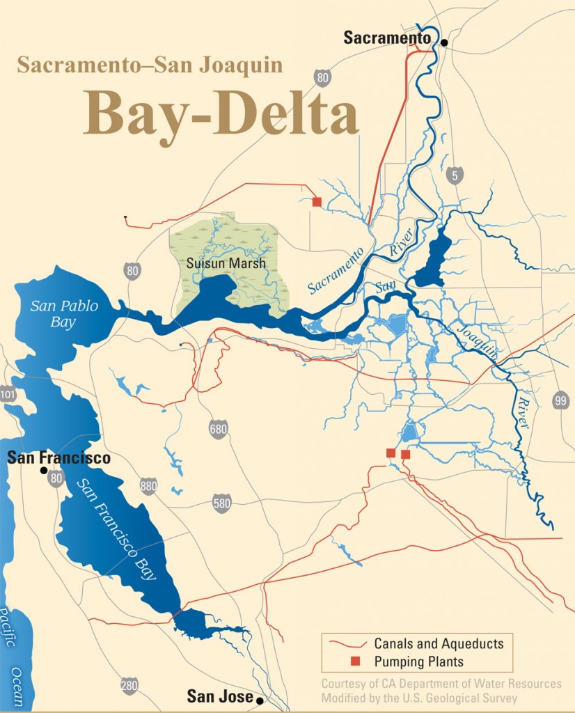
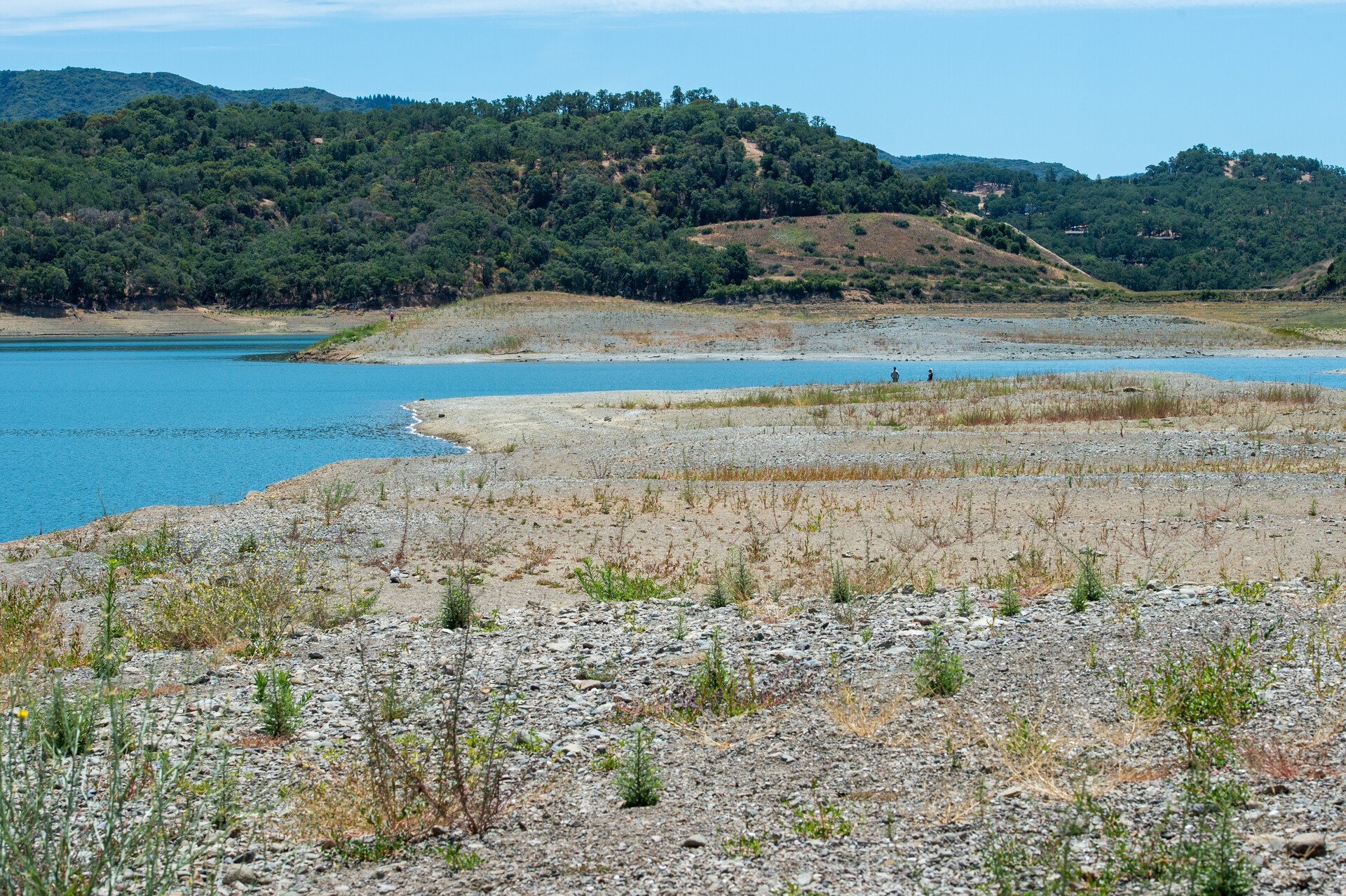
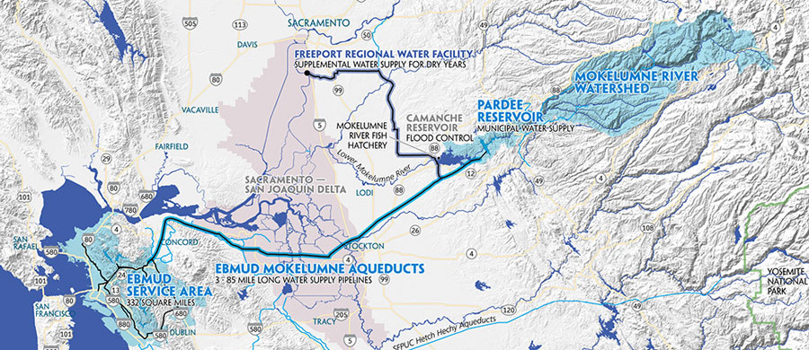