upper waypoint

New Quake Maps Could Shake Up Development Plans in Santa Monica

Save ArticleSave Article
Failed to save article

Please try again

Detail of CGS preliminary hazard map for the Santa Monica Fault (California Geological Survey)

The 1971 San Fernando (Sylmar) earthquake killed 64 people, buckled roadways and leveled scores of buildings. Soon after, California passed a law that requires updated mapping of major earthquake fault zones.

But due to a lack of funding, the effort ground to a halt not long after it began and resumed only about four years ago.

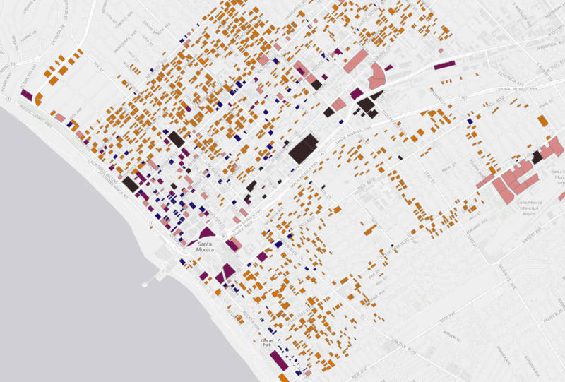
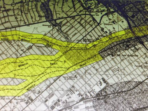
The California Geological Survey’s newly released mapping of the Santa Monica Fault could, if approved after a 90-day public comment period, prohibit new construction on top of active sections of the fault and require extensive geological review for proposed development within 500 feet.

“The Santa Monica and Hollywood faults historically have been fairly quiet since the area’s been settled, as far as we know,” says California Geological Survey senior engineer Timothy Dawson. "The major concern is that these faults cover some of the most densely populated areas in the L.A. basin.”

The Santa Monica Fault helped shape a roughly 30-mile stretch from Pasadena to the Pacific. It's why properties along sections of Santa Monica Boulevard in West L.A. -- like the immense temple of the Church of Jesus Christ of Latter-day Saints -- sit a little higher than those on the other side.

The Santa Monica Fault cleaves a path along portions of Santa Monica Boulevard creating steep slopes like the one that’s home to the Church of Jesus Christ of Latter-day Saints.
The Santa Monica Fault cleaves a path along portions of Santa Monica Boulevard, creating steep slopes like the one that’s home to the Church of Jesus Christ of Latter-day Saints. (Ken Lund/Flickr)

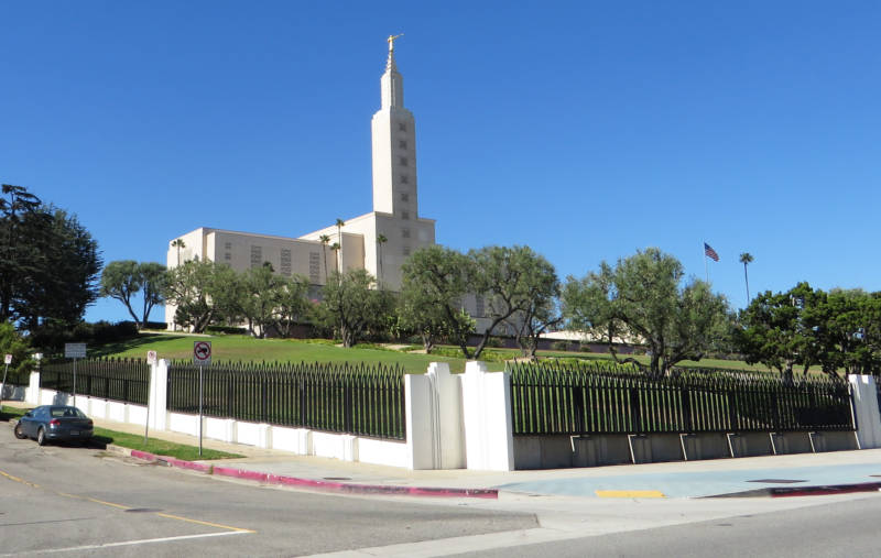
“What the fault has done mostly is create these things called fault scarps. The Mormon temple is actually on top of one of these fault scarps related to the Santa Monica Fault,” says Dawson. “Some geologists have referred to (it) as the most beautifully manicured fault scarp in the world.”

Sponsored

The new fault map drafts confirm what officials in Santa Monica have known for some time and have been preparing for. Earlier this year, the city approved what's widely seen as the most sweeping seismic retrofit program in California. The state mapping could give even more muscle to the effort by imposing an additional layer of guidelines for new construction.

“The draft map that CGS has released really affects new developments, redevelopment and reconstruction,” says Santa Monica city planner Jing Yeo.

“What this (state) mapping is intended to do is really highlight potential surface rupture. And that is a different consideration then the seismic retrofit program that the city is in the process of implementing,” says Yeo.

Santa Monica's program targets thousands of existing structures and is based more on building type vs. proximity to a fault. The effort’s been largely well received as a long overdue fix of vulnerable buildings in Santa Monica.

The city has created a searchable map of seismically vulnerable buildings:

The City of Santa Monica has created a list and searchable map of seismically vulnerable buildings.
Santa Monica has created a list and searchable map of seismically vulnerable buildings. (City of Santa Monica)

What impact the state’s new seismic hazard mapping could ultimately have on the city’s seismic upgrade plan and on future development is still uncertain.

“I think it'll bring greater awareness of the risks. I think that's good for any person that lives or works in Santa Monica,” says Martha Cox-Nitikman, senior director of public policy for the Building Owners and Managers Association of Greater Los Angeles. The association represents the interests of several large property owners in Santa Monica.

“The city might want to go back sometime later and update some of the engineering standards,” says Cox-Nitikman.

“Right now I think building owners are just looking at the standards that are in the (city) ordinance that we are currently living with, and there are standards in embedded in that.”

The new California Geological Survey fault hazard maps and the law behind it can only do so much. Ultimately it depends on local leaders in the affected communities to decide how strictly they’ll enforce the building standards outlined by the state.

lower waypoint
next waypoint
Pro-Palestinian Protests Sweep Bay Area College Campuses Amid Surging National MovementAt Least 16 People Died in California After Medics Injected Sedatives During Police EncountersState Court Upholds Alameda County Tax Measure Yielding Hundreds of Millions for Child CareYouth Takeover: Parents (and Teachers) Just Don't UnderstandCalifornia Regulators Just Approved New Rule to Cap Health Care Costs. Here's How It WorksSan José Adding Hundreds of License Plate Readers Amid Privacy and Efficacy ConcernsCalifornia Law Letting Property Owners Split Lots to Build New Homes Is 'Unconstitutional,' Judge RulesViolence Escalates in Sudan as Civil War Enters Second YearSF Emergency Dispatchers Struggle to Respond Amid Outdated Systems, Severe UnderstaffingLess Than 1% of Santa Clara County Contracts Go to Black and Latino Businesses, Study Shows