About two-thirds of Californians drink, bathe, brush their teeth, and flush their toilets with water that comes from the Sacramento-San Joaquin Delta. That's roughly 25 million people who get at least some portion of their hydration from one big triangular watering hole.
But ask most folks what the Delta is, and you're guaranteed to get a lot of blank stares. According to one recent poll, roughly four of five Californians are pretty clueless about it.
It's pretty easy to take for granted that water magically pours out of the tap when you turn your faucet on. But chances are, that H20 has gone through a pretty serious journey to reach you - and it's probably worth knowing where it comes from, and how safe the supply is.
Here's one of many things that's kind of funky about California: the majority of the population lives in the southern part of the state, but most of the available fresh water supply is in the northern half. So, to hydrate the millions of people living and farming in the state's drier regions, California has had to, ahem, tap the crap out of its available resources, pumping water hundreds of miles over large mountains to reach the populations that rely on it.
So what is the Delta?
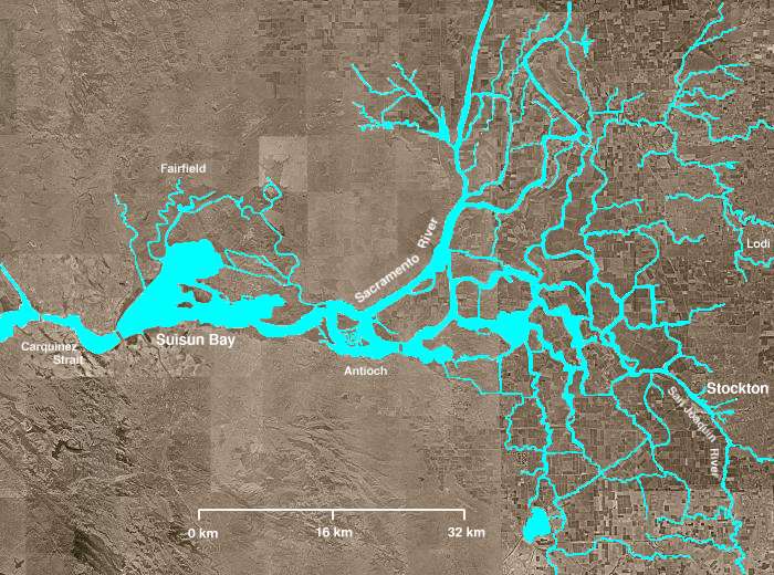
Just south of Sacramento on the western edge of the Central Valley is where California's two major rivers meet - the San Joaquin from the south and the Sacramento from the north. Between them, they drain almost half of California's freshwater supply, collecting and concentrating rainfall and snowmelt from the Sierra Nevada and funneling it towards the San Francisco Bay.
Sponsored
And this is what makes the Delta: a 700-square-mile inland estuary at the confluence of these two rivers, where fresh water from the mountains mixes with salt water from the Pacific.
Think of it as California's big drain.
How it used to be ...
Courtesy of Bay Nature Magazine; artist: Laura Cunningham
Before we started messing with it, the Delta was a vast brackish marsh filled with wetland plants (tules) and winding tidal channels. Much of it was submerged; all the fresh water from mountain snowmelt mixed with salt water from the ocean. In fact, when Spanish explorers first viewed the Delta from the top of Mt. Diablo in the late 1700s, they thought they'd discovered an inland sea. The area teemed with birds and game animals, including elk, antelope, and grizzly bears. Its few human inhabitants – small settlements of Miwok Indians – fished and hunted there only during summer months on small areas of dry land.
And how it is now ...
As you may have guessed, things are a bit different today. Over the last 150 years, we've dramatically and irreversibly changed the environment and landscape of the Delta, an epic effort to meet the steep demands of California’s increasingly crowded, thirsty population. Today's Delta is dotted with more than 1,000 miles of earthen walls - called levees. Much of the area has been "reclaimed" for agricultural use - land that's been drained and cordoned off by the levees. Huge pumps now deliver millions of gallons of fresh water to cities in the East Bay, South Bay, and throughout the lower half of the state, as well as farms in the arid San Joaquin Valley to the south.
A fragile system
In 2004, a breach in the Upper Jones Tract Levee flooded the surrounding farmlands and residential areas. The probable culprit: a rodent - possibly a beaver. (source: CA Department of Water Resources)
But the transformation has greatly upset the fragile environmental balance of the region, threatening many of the native fish and plant species that can't survive without steady streams of fresh water. The debate over how much water should be diverted from the Delta has long been a hot button political issue, instigating ongoing battles between northern and southern cities. It's also pitted environmentalists and ocean salmon fisherman against heavy water users, like farmers, who demand large consistent deliveries of fresh water diverted from the Delta.
The modern development of the Delta has also created an equally fragile water delivery system that millions of Californians depend on. Most of the levees are old and crumbling. If hit by a big enough earthquake, many would likely be destroyed. And because much of the reclaimed land in the region is below sea level (because of ongoing land subsidence), the area would be flooded, along with the nearly 400,000 people who live there.
Source: CA Dept. of Water Resources
Perhaps even more catastrophic: because the levees separate fresh water from salt water, if they collapse, the two types of water mix, leaving much of the state high and dry without a major source of fresh water.
Pretty serious business.
State leaders have been arguing for years about how to deal with this threat. A multibillion dollar water infrastructure ballot measure has repeatedly stalled, and now Governor Jerry Brown is floating the very costly prospect of building peripheral tunnels that would capture and divert fresh water before it even enters the Delta.
window.__IS_SSR__=true
window.__INITIAL_STATE__={"attachmentsReducer":{"audio_0":{"type":"attachments","id":"audio_0","imgSizes":{"kqedFullSize":{"file":"https://ww2.kqed.org/news/wp-content/themes/KQED-unified/img/audio_bgs/background0.jpg"}}},"audio_1":{"type":"attachments","id":"audio_1","imgSizes":{"kqedFullSize":{"file":"https://ww2.kqed.org/news/wp-content/themes/KQED-unified/img/audio_bgs/background1.jpg"}}},"audio_2":{"type":"attachments","id":"audio_2","imgSizes":{"kqedFullSize":{"file":"https://ww2.kqed.org/news/wp-content/themes/KQED-unified/img/audio_bgs/background2.jpg"}}},"audio_3":{"type":"attachments","id":"audio_3","imgSizes":{"kqedFullSize":{"file":"https://ww2.kqed.org/news/wp-content/themes/KQED-unified/img/audio_bgs/background3.jpg"}}},"audio_4":{"type":"attachments","id":"audio_4","imgSizes":{"kqedFullSize":{"file":"https://ww2.kqed.org/news/wp-content/themes/KQED-unified/img/audio_bgs/background4.jpg"}}},"placeholder":{"type":"attachments","id":"placeholder","imgSizes":{"thumbnail":{"file":"https://ww2.kqed.org/wp-content/uploads/sites/10/2018/01/GettyImages-896326950-160x96.jpg","width":160,"height":96,"mimeType":"image/jpeg"},"medium":{"file":"https://ww2.kqed.org/wp-content/uploads/sites/10/2018/01/GettyImages-896326950-800x478.jpg","width":800,"height":478,"mimeType":"image/jpeg"},"large":{"file":"https://ww2.kqed.org/wp-content/uploads/sites/10/2018/01/GettyImages-896326950-1020x610.jpg","width":1020,"height":610,"mimeType":"image/jpeg"},"fd-lrg":{"file":"https://ww2.kqed.org/wp-content/uploads/sites/10/2018/01/GettyImages-896326950-1920x1148.jpg","width":1920,"height":1148,"mimeType":"image/jpeg"},"fd-med":{"file":"https://ww2.kqed.org/wp-content/uploads/sites/10/2018/01/GettyImages-896326950-1180x705.jpg","width":1180,"height":705,"mimeType":"image/jpeg"},"fd-sm":{"file":"https://ww2.kqed.org/wp-content/uploads/sites/10/2018/01/GettyImages-896326950-960x574.jpg","width":960,"height":574,"mimeType":"image/jpeg"},"post-thumbnail":{"file":"https://ww2.kqed.org/wp-content/uploads/sites/10/2018/01/GettyImages-896326950-672x372.jpg","width":672,"height":372,"mimeType":"image/jpeg"},"twentyfourteen-full-width":{"file":"https://ww2.kqed.org/wp-content/uploads/sites/10/2018/01/GettyImages-896326950-1038x576.jpg","width":1038,"height":576,"mimeType":"image/jpeg"},"xxsmall":{"file":"https://ww2.kqed.org/wp-content/uploads/sites/10/2018/01/GettyImages-896326950-240x143.jpg","width":240,"height":143,"mimeType":"image/jpeg"},"xsmall":{"file":"https://ww2.kqed.org/wp-content/uploads/sites/10/2018/01/GettyImages-896326950-375x224.jpg","width":375,"height":224,"mimeType":"image/jpeg"},"small":{"file":"https://ww2.kqed.org/wp-content/uploads/sites/10/2018/01/GettyImages-896326950-520x311.jpg","width":520,"height":311,"mimeType":"image/jpeg"},"xlarge":{"file":"https://ww2.kqed.org/wp-content/uploads/sites/10/2018/01/GettyImages-896326950-1180x705.jpg","width":1180,"height":705,"mimeType":"image/jpeg"},"full-width":{"file":"https://ww2.kqed.org/wp-content/uploads/sites/10/2018/01/GettyImages-896326950-1920x1148.jpg","width":1920,"height":1148,"mimeType":"image/jpeg"},"guest-author-32":{"file":"https://ww2.kqed.org/wp-content/uploads/sites/10/2018/01/GettyImages-896326950-32x32.jpg","width":32,"height":32,"mimeType":"image/jpeg"},"guest-author-50":{"file":"https://ww2.kqed.org/wp-content/uploads/sites/10/2018/01/GettyImages-896326950-50x50.jpg","width":50,"height":50,"mimeType":"image/jpeg"},"guest-author-64":{"file":"https://ww2.kqed.org/wp-content/uploads/sites/10/2018/01/GettyImages-896326950-64x64.jpg","width":64,"height":64,"mimeType":"image/jpeg"},"guest-author-96":{"file":"https://ww2.kqed.org/wp-content/uploads/sites/10/2018/01/GettyImages-896326950-96x96.jpg","width":96,"height":96,"mimeType":"image/jpeg"},"guest-author-128":{"file":"https://ww2.kqed.org/wp-content/uploads/sites/10/2018/01/GettyImages-896326950-128x128.jpg","width":128,"height":128,"mimeType":"image/jpeg"},"detail":{"file":"https://ww2.kqed.org/wp-content/uploads/sites/10/2018/01/GettyImages-896326950-150x150.jpg","width":150,"height":150,"mimeType":"image/jpeg"},"kqedFullSize":{"file":"https://ww2.kqed.org/wp-content/uploads/sites/10/2018/01/GettyImages-896326950-e1514998105161.jpg","width":1920,"height":1148}}},"lowdown_31044":{"type":"attachments","id":"lowdown_31044","meta":{"index":"attachments_1591205162","site":"lowdown","id":"31044","found":true},"title":"Northern-Triangle_color_full copy","publishDate":1537554902,"status":"inherit","parent":31036,"modified":1537554902,"caption":null,"credit":null,"description":null,"imgSizes":{"thumbnail":{"file":"https://ww2.kqed.org/app/uploads/sites/26/2018/08/Northern-Triangle_color_full-copy-160x112.png","width":160,"height":112,"mimeType":"image/png"},"post-thumbnail":{"file":"https://ww2.kqed.org/app/uploads/sites/26/2018/08/Northern-Triangle_color_full-copy-605x372.png","width":605,"height":372,"mimeType":"image/png"},"xxsmall":{"file":"https://ww2.kqed.org/app/uploads/sites/26/2018/08/Northern-Triangle_color_full-copy-240x168.png","width":240,"height":168,"mimeType":"image/png"},"xsmall":{"file":"https://ww2.kqed.org/app/uploads/sites/26/2018/08/Northern-Triangle_color_full-copy-375x262.png","width":375,"height":262,"mimeType":"image/png"},"small":{"file":"https://ww2.kqed.org/app/uploads/sites/26/2018/08/Northern-Triangle_color_full-copy-520x364.png","width":520,"height":364,"mimeType":"image/png"},"guest-author-32":{"file":"https://ww2.kqed.org/app/uploads/sites/26/2018/08/Northern-Triangle_color_full-copy-32x32.png","width":32,"height":32,"mimeType":"image/png"},"guest-author-50":{"file":"https://ww2.kqed.org/app/uploads/sites/26/2018/08/Northern-Triangle_color_full-copy-50x50.png","width":50,"height":50,"mimeType":"image/png"},"guest-author-64":{"file":"https://ww2.kqed.org/app/uploads/sites/26/2018/08/Northern-Triangle_color_full-copy-64x64.png","width":64,"height":64,"mimeType":"image/png"},"guest-author-96":{"file":"https://ww2.kqed.org/app/uploads/sites/26/2018/08/Northern-Triangle_color_full-copy-96x96.png","width":96,"height":96,"mimeType":"image/png"},"guest-author-128":{"file":"https://ww2.kqed.org/app/uploads/sites/26/2018/08/Northern-Triangle_color_full-copy-128x128.png","width":128,"height":128,"mimeType":"image/png"},"detail":{"file":"https://ww2.kqed.org/app/uploads/sites/26/2018/08/Northern-Triangle_color_full-copy-150x150.png","width":150,"height":150,"mimeType":"image/png"},"kqedFullSize":{"file":"https://ww2.kqed.org/app/uploads/sites/26/2018/08/Northern-Triangle_color_full-copy.png","width":605,"height":423}},"fetchFailed":false,"isLoading":false},"lowdown_30959":{"type":"attachments","id":"lowdown_30959","meta":{"index":"attachments_1591205162","site":"lowdown","id":"30959","found":true},"title":"Screen Shot 2018-05-15 at 11.04.40 AM","publishDate":1526407508,"status":"inherit","parent":13923,"modified":1526407508,"caption":null,"credit":null,"description":null,"imgSizes":{"thumbnail":{"file":"https://ww2.kqed.org/app/uploads/sites/26/2018/05/Screen-Shot-2018-05-15-at-11.04.40-AM-160x105.png","width":160,"height":105,"mimeType":"image/png"},"medium":{"file":"https://ww2.kqed.org/app/uploads/sites/26/2018/05/Screen-Shot-2018-05-15-at-11.04.40-AM-800x524.png","width":800,"height":524,"mimeType":"image/png"},"medium_large":{"file":"https://ww2.kqed.org/app/uploads/sites/26/2018/05/Screen-Shot-2018-05-15-at-11.04.40-AM-768x503.png","width":768,"height":503,"mimeType":"image/png"},"large":{"file":"https://ww2.kqed.org/app/uploads/sites/26/2018/05/Screen-Shot-2018-05-15-at-11.04.40-AM-1020x668.png","width":1020,"height":668,"mimeType":"image/png"},"complete_open_graph":{"file":"https://ww2.kqed.org/app/uploads/sites/26/2018/05/Screen-Shot-2018-05-15-at-11.04.40-AM-1200x785.png","width":1200,"height":785,"mimeType":"image/png"},"fd-med":{"file":"https://ww2.kqed.org/app/uploads/sites/26/2018/05/Screen-Shot-2018-05-15-at-11.04.40-AM-1180x772.png","width":1180,"height":772,"mimeType":"image/png"},"fd-sm":{"file":"https://ww2.kqed.org/app/uploads/sites/26/2018/05/Screen-Shot-2018-05-15-at-11.04.40-AM-960x628.png","width":960,"height":628,"mimeType":"image/png"},"post-thumbnail":{"file":"https://ww2.kqed.org/app/uploads/sites/26/2018/05/Screen-Shot-2018-05-15-at-11.04.40-AM-672x372.png","width":672,"height":372,"mimeType":"image/png"},"twentyfourteen-full-width":{"file":"https://ww2.kqed.org/app/uploads/sites/26/2018/05/Screen-Shot-2018-05-15-at-11.04.40-AM-1038x576.png","width":1038,"height":576,"mimeType":"image/png"},"xxsmall":{"file":"https://ww2.kqed.org/app/uploads/sites/26/2018/05/Screen-Shot-2018-05-15-at-11.04.40-AM-240x157.png","width":240,"height":157,"mimeType":"image/png"},"xsmall":{"file":"https://ww2.kqed.org/app/uploads/sites/26/2018/05/Screen-Shot-2018-05-15-at-11.04.40-AM-375x245.png","width":375,"height":245,"mimeType":"image/png"},"small":{"file":"https://ww2.kqed.org/app/uploads/sites/26/2018/05/Screen-Shot-2018-05-15-at-11.04.40-AM-520x340.png","width":520,"height":340,"mimeType":"image/png"},"xlarge":{"file":"https://ww2.kqed.org/app/uploads/sites/26/2018/05/Screen-Shot-2018-05-15-at-11.04.40-AM-1180x772.png","width":1180,"height":772,"mimeType":"image/png"},"guest-author-32":{"file":"https://ww2.kqed.org/app/uploads/sites/26/2018/05/Screen-Shot-2018-05-15-at-11.04.40-AM-32x32.png","width":32,"height":32,"mimeType":"image/png"},"guest-author-50":{"file":"https://ww2.kqed.org/app/uploads/sites/26/2018/05/Screen-Shot-2018-05-15-at-11.04.40-AM-50x50.png","width":50,"height":50,"mimeType":"image/png"},"guest-author-64":{"file":"https://ww2.kqed.org/app/uploads/sites/26/2018/05/Screen-Shot-2018-05-15-at-11.04.40-AM-64x64.png","width":64,"height":64,"mimeType":"image/png"},"guest-author-96":{"file":"https://ww2.kqed.org/app/uploads/sites/26/2018/05/Screen-Shot-2018-05-15-at-11.04.40-AM-96x96.png","width":96,"height":96,"mimeType":"image/png"},"guest-author-128":{"file":"https://ww2.kqed.org/app/uploads/sites/26/2018/05/Screen-Shot-2018-05-15-at-11.04.40-AM-128x128.png","width":128,"height":128,"mimeType":"image/png"},"detail":{"file":"https://ww2.kqed.org/app/uploads/sites/26/2018/05/Screen-Shot-2018-05-15-at-11.04.40-AM-150x150.png","width":150,"height":150,"mimeType":"image/png"},"kqedFullSize":{"file":"https://ww2.kqed.org/app/uploads/sites/26/2018/05/Screen-Shot-2018-05-15-at-11.04.40-AM.png","width":1224,"height":801}},"fetchFailed":false,"isLoading":false},"lowdown_30838":{"type":"attachments","id":"lowdown_30838","meta":{"index":"attachments_1591205162","site":"lowdown","id":"30838","found":true},"title":"Youth-Take-Over-Banner-Group-Photo-2-1020x574","publishDate":1524608297,"status":"inherit","parent":30833,"modified":1524608315,"caption":"Youth Takeover students from Santa Clara High School, Lincoln High School, San Leandro High School, Menlo-Atherton High School and El Cerrito High School.\n","credit":"Chanelle Ignant","description":null,"imgSizes":{"thumbnail":{"file":"https://ww2.kqed.org/app/uploads/sites/26/2018/04/Youth-Take-Over-Banner-Group-Photo-2-1020x574-160x90.jpg","width":160,"height":90,"mimeType":"image/jpeg"},"medium":{"file":"https://ww2.kqed.org/app/uploads/sites/26/2018/04/Youth-Take-Over-Banner-Group-Photo-2-1020x574-800x450.jpg","width":800,"height":450,"mimeType":"image/jpeg"},"medium_large":{"file":"https://ww2.kqed.org/app/uploads/sites/26/2018/04/Youth-Take-Over-Banner-Group-Photo-2-1020x574-768x432.jpg","width":768,"height":432,"mimeType":"image/jpeg"},"large":{"file":"https://ww2.kqed.org/app/uploads/sites/26/2018/04/Youth-Take-Over-Banner-Group-Photo-2-1020x574-1020x574.jpg","width":1020,"height":574,"mimeType":"image/jpeg"},"fd-sm":{"file":"https://ww2.kqed.org/app/uploads/sites/26/2018/04/Youth-Take-Over-Banner-Group-Photo-2-1020x574-960x540.jpg","width":960,"height":540,"mimeType":"image/jpeg"},"post-thumbnail":{"file":"https://ww2.kqed.org/app/uploads/sites/26/2018/04/Youth-Take-Over-Banner-Group-Photo-2-1020x574-672x372.jpg","width":672,"height":372,"mimeType":"image/jpeg"},"xxsmall":{"file":"https://ww2.kqed.org/app/uploads/sites/26/2018/04/Youth-Take-Over-Banner-Group-Photo-2-1020x574-240x135.jpg","width":240,"height":135,"mimeType":"image/jpeg"},"xsmall":{"file":"https://ww2.kqed.org/app/uploads/sites/26/2018/04/Youth-Take-Over-Banner-Group-Photo-2-1020x574-375x211.jpg","width":375,"height":211,"mimeType":"image/jpeg"},"small":{"file":"https://ww2.kqed.org/app/uploads/sites/26/2018/04/Youth-Take-Over-Banner-Group-Photo-2-1020x574-520x293.jpg","width":520,"height":293,"mimeType":"image/jpeg"},"guest-author-32":{"file":"https://ww2.kqed.org/app/uploads/sites/26/2018/04/Youth-Take-Over-Banner-Group-Photo-2-1020x574-32x32.jpg","width":32,"height":32,"mimeType":"image/jpeg"},"guest-author-50":{"file":"https://ww2.kqed.org/app/uploads/sites/26/2018/04/Youth-Take-Over-Banner-Group-Photo-2-1020x574-50x50.jpg","width":50,"height":50,"mimeType":"image/jpeg"},"guest-author-64":{"file":"https://ww2.kqed.org/app/uploads/sites/26/2018/04/Youth-Take-Over-Banner-Group-Photo-2-1020x574-64x64.jpg","width":64,"height":64,"mimeType":"image/jpeg"},"guest-author-96":{"file":"https://ww2.kqed.org/app/uploads/sites/26/2018/04/Youth-Take-Over-Banner-Group-Photo-2-1020x574-96x96.jpg","width":96,"height":96,"mimeType":"image/jpeg"},"guest-author-128":{"file":"https://ww2.kqed.org/app/uploads/sites/26/2018/04/Youth-Take-Over-Banner-Group-Photo-2-1020x574-128x128.jpg","width":128,"height":128,"mimeType":"image/jpeg"},"detail":{"file":"https://ww2.kqed.org/app/uploads/sites/26/2018/04/Youth-Take-Over-Banner-Group-Photo-2-1020x574-150x150.jpg","width":150,"height":150,"mimeType":"image/jpeg"},"kqedFullSize":{"file":"https://ww2.kqed.org/app/uploads/sites/26/2018/04/Youth-Take-Over-Banner-Group-Photo-2-1020x574.jpg","width":1020,"height":574}},"fetchFailed":false,"isLoading":false},"lowdown_26637":{"type":"attachments","id":"lowdown_26637","meta":{"index":"attachments_1591205162","site":"lowdown","id":"26637","found":true},"title":"earth day","publishDate":1492569770,"status":"inherit","parent":21839,"modified":1492579657,"caption":"A college student in a gas mask \"smells\" a magnolia blossom in New York's City Hall Park on the first Earth Day in 1970.","credit":"AP/Wide World Photos","description":null,"imgSizes":{"thumbnail":{"file":"https://ww2.kqed.org/app/uploads/sites/26/2016/04/earth-day-160x128.jpeg","width":160,"height":128,"mimeType":"image/jpeg"},"medium":{"file":"https://ww2.kqed.org/app/uploads/sites/26/2016/04/earth-day-800x640.jpeg","width":800,"height":640,"mimeType":"image/jpeg"},"medium_large":{"file":"https://ww2.kqed.org/app/uploads/sites/26/2016/04/earth-day-768x614.jpeg","width":768,"height":614,"mimeType":"image/jpeg"},"fd-sm":{"file":"https://ww2.kqed.org/app/uploads/sites/26/2016/04/earth-day-960x768.jpeg","width":960,"height":768,"mimeType":"image/jpeg"},"post-thumbnail":{"file":"https://ww2.kqed.org/app/uploads/sites/26/2016/04/earth-day-672x372.jpeg","width":672,"height":372,"mimeType":"image/jpeg"},"twentyfourteen-full-width":{"file":"https://ww2.kqed.org/app/uploads/sites/26/2016/04/earth-day-960x576.jpeg","width":960,"height":576,"mimeType":"image/jpeg"},"xxsmall":{"file":"https://ww2.kqed.org/app/uploads/sites/26/2016/04/earth-day-240x192.jpeg","width":240,"height":192,"mimeType":"image/jpeg"},"xsmall":{"file":"https://ww2.kqed.org/app/uploads/sites/26/2016/04/earth-day-375x300.jpeg","width":375,"height":300,"mimeType":"image/jpeg"},"small":{"file":"https://ww2.kqed.org/app/uploads/sites/26/2016/04/earth-day-520x416.jpeg","width":520,"height":416,"mimeType":"image/jpeg"},"guest-author-32":{"file":"https://ww2.kqed.org/app/uploads/sites/26/2016/04/earth-day-32x32.jpeg","width":32,"height":32,"mimeType":"image/jpeg"},"guest-author-50":{"file":"https://ww2.kqed.org/app/uploads/sites/26/2016/04/earth-day-50x50.jpeg","width":50,"height":50,"mimeType":"image/jpeg"},"guest-author-64":{"file":"https://ww2.kqed.org/app/uploads/sites/26/2016/04/earth-day-64x64.jpeg","width":64,"height":64,"mimeType":"image/jpeg"},"guest-author-96":{"file":"https://ww2.kqed.org/app/uploads/sites/26/2016/04/earth-day-96x96.jpeg","width":96,"height":96,"mimeType":"image/jpeg"},"guest-author-128":{"file":"https://ww2.kqed.org/app/uploads/sites/26/2016/04/earth-day-128x128.jpeg","width":128,"height":128,"mimeType":"image/jpeg"},"detail":{"file":"https://ww2.kqed.org/app/uploads/sites/26/2016/04/earth-day-150x150.jpeg","width":150,"height":150,"mimeType":"image/jpeg"},"kqedFullSize":{"file":"https://ww2.kqed.org/app/uploads/sites/26/2016/04/earth-day.jpeg","width":960,"height":768}},"fetchFailed":false,"isLoading":false},"lowdown_30773":{"type":"attachments","id":"lowdown_30773","meta":{"index":"attachments_1591205162","site":"lowdown","id":"30773","found":true},"title":"vaping","publishDate":1524517990,"status":"inherit","parent":30662,"modified":1524517990,"caption":null,"credit":null,"description":null,"imgSizes":{"thumbnail":{"file":"https://ww2.kqed.org/app/uploads/sites/26/2018/04/vaping-160x90.jpg","width":160,"height":90,"mimeType":"image/jpeg"},"medium":{"file":"https://ww2.kqed.org/app/uploads/sites/26/2018/04/vaping-800x450.jpg","width":800,"height":450,"mimeType":"image/jpeg"},"medium_large":{"file":"https://ww2.kqed.org/app/uploads/sites/26/2018/04/vaping-768x432.jpg","width":768,"height":432,"mimeType":"image/jpeg"},"large":{"file":"https://ww2.kqed.org/app/uploads/sites/26/2018/04/vaping-1020x574.jpg","width":1020,"height":574,"mimeType":"image/jpeg"},"complete_open_graph":{"file":"https://ww2.kqed.org/app/uploads/sites/26/2018/04/vaping-1200x675.jpg","width":1200,"height":675,"mimeType":"image/jpeg"},"fd-med":{"file":"https://ww2.kqed.org/app/uploads/sites/26/2018/04/vaping-1180x664.jpg","width":1180,"height":664,"mimeType":"image/jpeg"},"fd-sm":{"file":"https://ww2.kqed.org/app/uploads/sites/26/2018/04/vaping-960x540.jpg","width":960,"height":540,"mimeType":"image/jpeg"},"post-thumbnail":{"file":"https://ww2.kqed.org/app/uploads/sites/26/2018/04/vaping-672x372.jpg","width":672,"height":372,"mimeType":"image/jpeg"},"twentyfourteen-full-width":{"file":"https://ww2.kqed.org/app/uploads/sites/26/2018/04/vaping-1038x576.jpg","width":1038,"height":576,"mimeType":"image/jpeg"},"xxsmall":{"file":"https://ww2.kqed.org/app/uploads/sites/26/2018/04/vaping-240x135.jpg","width":240,"height":135,"mimeType":"image/jpeg"},"xsmall":{"file":"https://ww2.kqed.org/app/uploads/sites/26/2018/04/vaping-375x211.jpg","width":375,"height":211,"mimeType":"image/jpeg"},"small":{"file":"https://ww2.kqed.org/app/uploads/sites/26/2018/04/vaping-520x293.jpg","width":520,"height":293,"mimeType":"image/jpeg"},"xlarge":{"file":"https://ww2.kqed.org/app/uploads/sites/26/2018/04/vaping-1180x664.jpg","width":1180,"height":664,"mimeType":"image/jpeg"},"guest-author-32":{"file":"https://ww2.kqed.org/app/uploads/sites/26/2018/04/vaping-32x32.jpg","width":32,"height":32,"mimeType":"image/jpeg"},"guest-author-50":{"file":"https://ww2.kqed.org/app/uploads/sites/26/2018/04/vaping-50x50.jpg","width":50,"height":50,"mimeType":"image/jpeg"},"guest-author-64":{"file":"https://ww2.kqed.org/app/uploads/sites/26/2018/04/vaping-64x64.jpg","width":64,"height":64,"mimeType":"image/jpeg"},"guest-author-96":{"file":"https://ww2.kqed.org/app/uploads/sites/26/2018/04/vaping-96x96.jpg","width":96,"height":96,"mimeType":"image/jpeg"},"guest-author-128":{"file":"https://ww2.kqed.org/app/uploads/sites/26/2018/04/vaping-128x128.jpg","width":128,"height":128,"mimeType":"image/jpeg"},"detail":{"file":"https://ww2.kqed.org/app/uploads/sites/26/2018/04/vaping-150x150.jpg","width":150,"height":150,"mimeType":"image/jpeg"},"kqedFullSize":{"file":"https://ww2.kqed.org/app/uploads/sites/26/2018/04/vaping.jpg","width":1280,"height":720}},"fetchFailed":false,"isLoading":false},"lowdown_26559":{"type":"attachments","id":"lowdown_26559","meta":{"index":"attachments_1591205162","site":"lowdown","id":"26559","found":true},"title":"Pencil with tax form on US dollarbills background","publishDate":1492118820,"status":"inherit","parent":26549,"modified":1492118863,"caption":null,"credit":"LIgorko/iStock","description":null,"imgSizes":{"thumbnail":{"file":"https://ww2.kqed.org/app/uploads/sites/26/2017/04/iStock-507839992-160x113.jpg","width":160,"height":113,"mimeType":"image/jpeg"},"medium":{"file":"https://ww2.kqed.org/app/uploads/sites/26/2017/04/iStock-507839992-800x567.jpg","width":800,"height":567,"mimeType":"image/jpeg"},"medium_large":{"file":"https://ww2.kqed.org/app/uploads/sites/26/2017/04/iStock-507839992-768x545.jpg","width":768,"height":545,"mimeType":"image/jpeg"},"large":{"file":"https://ww2.kqed.org/app/uploads/sites/26/2017/04/iStock-507839992-1020x723.jpg","width":1020,"height":723,"mimeType":"image/jpeg"},"fd-lrg":{"file":"https://ww2.kqed.org/app/uploads/sites/26/2017/04/iStock-507839992-1920x1362.jpg","width":1920,"height":1362,"mimeType":"image/jpeg"},"fd-med":{"file":"https://ww2.kqed.org/app/uploads/sites/26/2017/04/iStock-507839992-1180x837.jpg","width":1180,"height":837,"mimeType":"image/jpeg"},"fd-sm":{"file":"https://ww2.kqed.org/app/uploads/sites/26/2017/04/iStock-507839992-960x681.jpg","width":960,"height":681,"mimeType":"image/jpeg"},"post-thumbnail":{"file":"https://ww2.kqed.org/app/uploads/sites/26/2017/04/iStock-507839992-672x372.jpg","width":672,"height":372,"mimeType":"image/jpeg"},"twentyfourteen-full-width":{"file":"https://ww2.kqed.org/app/uploads/sites/26/2017/04/iStock-507839992-1038x576.jpg","width":1038,"height":576,"mimeType":"image/jpeg"},"xxsmall":{"file":"https://ww2.kqed.org/app/uploads/sites/26/2017/04/iStock-507839992-240x170.jpg","width":240,"height":170,"mimeType":"image/jpeg"},"xsmall":{"file":"https://ww2.kqed.org/app/uploads/sites/26/2017/04/iStock-507839992-375x266.jpg","width":375,"height":266,"mimeType":"image/jpeg"},"small":{"file":"https://ww2.kqed.org/app/uploads/sites/26/2017/04/iStock-507839992-520x369.jpg","width":520,"height":369,"mimeType":"image/jpeg"},"xlarge":{"file":"https://ww2.kqed.org/app/uploads/sites/26/2017/04/iStock-507839992-1180x837.jpg","width":1180,"height":837,"mimeType":"image/jpeg"},"full-width":{"file":"https://ww2.kqed.org/app/uploads/sites/26/2017/04/iStock-507839992-1920x1362.jpg","width":1920,"height":1362,"mimeType":"image/jpeg"},"guest-author-32":{"file":"https://ww2.kqed.org/app/uploads/sites/26/2017/04/iStock-507839992-32x32.jpg","width":32,"height":32,"mimeType":"image/jpeg"},"guest-author-50":{"file":"https://ww2.kqed.org/app/uploads/sites/26/2017/04/iStock-507839992-50x50.jpg","width":50,"height":50,"mimeType":"image/jpeg"},"guest-author-64":{"file":"https://ww2.kqed.org/app/uploads/sites/26/2017/04/iStock-507839992-64x64.jpg","width":64,"height":64,"mimeType":"image/jpeg"},"guest-author-96":{"file":"https://ww2.kqed.org/app/uploads/sites/26/2017/04/iStock-507839992-96x96.jpg","width":96,"height":96,"mimeType":"image/jpeg"},"guest-author-128":{"file":"https://ww2.kqed.org/app/uploads/sites/26/2017/04/iStock-507839992-128x128.jpg","width":128,"height":128,"mimeType":"image/jpeg"},"detail":{"file":"https://ww2.kqed.org/app/uploads/sites/26/2017/04/iStock-507839992-150x150.jpg","width":150,"height":150,"mimeType":"image/jpeg"},"kqedFullSize":{"file":"https://ww2.kqed.org/app/uploads/sites/26/2017/04/iStock-507839992.jpg","width":2056,"height":1458}},"fetchFailed":false,"isLoading":false},"lowdown_30776":{"type":"attachments","id":"lowdown_30776","meta":{"index":"attachments_1591205162","site":"lowdown","id":"30776","found":true},"title":"Species Extinction Thumbnail","publishDate":1524518205,"status":"inherit","parent":30538,"modified":1524518205,"caption":null,"credit":null,"description":null,"imgSizes":{"thumbnail":{"file":"https://ww2.kqed.org/app/uploads/sites/26/2018/04/Species-Extinction-Thumbnail-160x90.png","width":160,"height":90,"mimeType":"image/png"},"medium":{"file":"https://ww2.kqed.org/app/uploads/sites/26/2018/04/Species-Extinction-Thumbnail-800x450.png","width":800,"height":450,"mimeType":"image/png"},"medium_large":{"file":"https://ww2.kqed.org/app/uploads/sites/26/2018/04/Species-Extinction-Thumbnail-768x432.png","width":768,"height":432,"mimeType":"image/png"},"large":{"file":"https://ww2.kqed.org/app/uploads/sites/26/2018/04/Species-Extinction-Thumbnail-1020x574.png","width":1020,"height":574,"mimeType":"image/png"},"complete_open_graph":{"file":"https://ww2.kqed.org/app/uploads/sites/26/2018/04/Species-Extinction-Thumbnail-1200x675.png","width":1200,"height":675,"mimeType":"image/png"},"fd-lrg":{"file":"https://ww2.kqed.org/app/uploads/sites/26/2018/04/Species-Extinction-Thumbnail-1920x1080.png","width":1920,"height":1080,"mimeType":"image/png"},"fd-med":{"file":"https://ww2.kqed.org/app/uploads/sites/26/2018/04/Species-Extinction-Thumbnail-1180x664.png","width":1180,"height":664,"mimeType":"image/png"},"fd-sm":{"file":"https://ww2.kqed.org/app/uploads/sites/26/2018/04/Species-Extinction-Thumbnail-960x540.png","width":960,"height":540,"mimeType":"image/png"},"post-thumbnail":{"file":"https://ww2.kqed.org/app/uploads/sites/26/2018/04/Species-Extinction-Thumbnail-672x372.png","width":672,"height":372,"mimeType":"image/png"},"twentyfourteen-full-width":{"file":"https://ww2.kqed.org/app/uploads/sites/26/2018/04/Species-Extinction-Thumbnail-1038x576.png","width":1038,"height":576,"mimeType":"image/png"},"xxsmall":{"file":"https://ww2.kqed.org/app/uploads/sites/26/2018/04/Species-Extinction-Thumbnail-240x135.png","width":240,"height":135,"mimeType":"image/png"},"xsmall":{"file":"https://ww2.kqed.org/app/uploads/sites/26/2018/04/Species-Extinction-Thumbnail-375x211.png","width":375,"height":211,"mimeType":"image/png"},"small":{"file":"https://ww2.kqed.org/app/uploads/sites/26/2018/04/Species-Extinction-Thumbnail-520x293.png","width":520,"height":293,"mimeType":"image/png"},"xlarge":{"file":"https://ww2.kqed.org/app/uploads/sites/26/2018/04/Species-Extinction-Thumbnail-1180x664.png","width":1180,"height":664,"mimeType":"image/png"},"full-width":{"file":"https://ww2.kqed.org/app/uploads/sites/26/2018/04/Species-Extinction-Thumbnail-1920x1080.png","width":1920,"height":1080,"mimeType":"image/png"},"guest-author-32":{"file":"https://ww2.kqed.org/app/uploads/sites/26/2018/04/Species-Extinction-Thumbnail-32x32.png","width":32,"height":32,"mimeType":"image/png"},"guest-author-50":{"file":"https://ww2.kqed.org/app/uploads/sites/26/2018/04/Species-Extinction-Thumbnail-50x50.png","width":50,"height":50,"mimeType":"image/png"},"guest-author-64":{"file":"https://ww2.kqed.org/app/uploads/sites/26/2018/04/Species-Extinction-Thumbnail-64x64.png","width":64,"height":64,"mimeType":"image/png"},"guest-author-96":{"file":"https://ww2.kqed.org/app/uploads/sites/26/2018/04/Species-Extinction-Thumbnail-96x96.png","width":96,"height":96,"mimeType":"image/png"},"guest-author-128":{"file":"https://ww2.kqed.org/app/uploads/sites/26/2018/04/Species-Extinction-Thumbnail-128x128.png","width":128,"height":128,"mimeType":"image/png"},"detail":{"file":"https://ww2.kqed.org/app/uploads/sites/26/2018/04/Species-Extinction-Thumbnail-150x150.png","width":150,"height":150,"mimeType":"image/png"},"kqedFullSize":{"file":"https://ww2.kqed.org/app/uploads/sites/26/2018/04/Species-Extinction-Thumbnail.png","width":1920,"height":1080}},"fetchFailed":false,"isLoading":false},"lowdown_26420":{"type":"attachments","id":"lowdown_26420","meta":{"index":"attachments_1591205162","site":"lowdown","id":"26420","found":true},"title":"2353429145_9385c4dd9b_o","publishDate":1490935162,"status":"inherit","parent":16782,"modified":1490935702,"caption":"UCLA battles Texas A&M in 2008.","credit":"\u003ca href=\"https://www.flickr.com/photos/dirkhansen/2353429145\">SD Dirk/Flickr\u003c/a>","description":null,"imgSizes":{"thumbnail":{"file":"https://ww2.kqed.org/app/uploads/sites/26/2017/03/2353429145_9385c4dd9b_o-160x106.jpg","width":160,"height":106,"mimeType":"image/jpeg"},"medium":{"file":"https://ww2.kqed.org/app/uploads/sites/26/2017/03/2353429145_9385c4dd9b_o-800x531.jpg","width":800,"height":531,"mimeType":"image/jpeg"},"medium_large":{"file":"https://ww2.kqed.org/app/uploads/sites/26/2017/03/2353429145_9385c4dd9b_o-768x510.jpg","width":768,"height":510,"mimeType":"image/jpeg"},"large":{"file":"https://ww2.kqed.org/app/uploads/sites/26/2017/03/2353429145_9385c4dd9b_o-1020x677.jpg","width":1020,"height":677,"mimeType":"image/jpeg"},"fd-med":{"file":"https://ww2.kqed.org/app/uploads/sites/26/2017/03/2353429145_9385c4dd9b_o-1180x784.jpg","width":1180,"height":784,"mimeType":"image/jpeg"},"fd-sm":{"file":"https://ww2.kqed.org/app/uploads/sites/26/2017/03/2353429145_9385c4dd9b_o-960x638.jpg","width":960,"height":638,"mimeType":"image/jpeg"},"post-thumbnail":{"file":"https://ww2.kqed.org/app/uploads/sites/26/2017/03/2353429145_9385c4dd9b_o-672x372.jpg","width":672,"height":372,"mimeType":"image/jpeg"},"twentyfourteen-full-width":{"file":"https://ww2.kqed.org/app/uploads/sites/26/2017/03/2353429145_9385c4dd9b_o-1038x576.jpg","width":1038,"height":576,"mimeType":"image/jpeg"},"xxsmall":{"file":"https://ww2.kqed.org/app/uploads/sites/26/2017/03/2353429145_9385c4dd9b_o-240x159.jpg","width":240,"height":159,"mimeType":"image/jpeg"},"xsmall":{"file":"https://ww2.kqed.org/app/uploads/sites/26/2017/03/2353429145_9385c4dd9b_o-375x249.jpg","width":375,"height":249,"mimeType":"image/jpeg"},"small":{"file":"https://ww2.kqed.org/app/uploads/sites/26/2017/03/2353429145_9385c4dd9b_o-520x345.jpg","width":520,"height":345,"mimeType":"image/jpeg"},"xlarge":{"file":"https://ww2.kqed.org/app/uploads/sites/26/2017/03/2353429145_9385c4dd9b_o-1180x784.jpg","width":1180,"height":784,"mimeType":"image/jpeg"},"guest-author-32":{"file":"https://ww2.kqed.org/app/uploads/sites/26/2017/03/2353429145_9385c4dd9b_o-32x32.jpg","width":32,"height":32,"mimeType":"image/jpeg"},"guest-author-50":{"file":"https://ww2.kqed.org/app/uploads/sites/26/2017/03/2353429145_9385c4dd9b_o-50x50.jpg","width":50,"height":50,"mimeType":"image/jpeg"},"guest-author-64":{"file":"https://ww2.kqed.org/app/uploads/sites/26/2017/03/2353429145_9385c4dd9b_o-64x64.jpg","width":64,"height":64,"mimeType":"image/jpeg"},"guest-author-96":{"file":"https://ww2.kqed.org/app/uploads/sites/26/2017/03/2353429145_9385c4dd9b_o-96x96.jpg","width":96,"height":96,"mimeType":"image/jpeg"},"guest-author-128":{"file":"https://ww2.kqed.org/app/uploads/sites/26/2017/03/2353429145_9385c4dd9b_o-128x128.jpg","width":128,"height":128,"mimeType":"image/jpeg"},"detail":{"file":"https://ww2.kqed.org/app/uploads/sites/26/2017/03/2353429145_9385c4dd9b_o-150x150.jpg","width":150,"height":150,"mimeType":"image/jpeg"},"kqedFullSize":{"file":"https://ww2.kqed.org/app/uploads/sites/26/2017/03/2353429145_9385c4dd9b_o.jpg","width":1280,"height":850}},"fetchFailed":false,"isLoading":false},"lowdown_30440":{"type":"attachments","id":"lowdown_30440","meta":{"index":"attachments_1591205162","site":"lowdown","id":"30440","found":true},"title":"NUKES THUMBNAIL2","publishDate":1521667910,"status":"inherit","parent":30398,"modified":1521667910,"caption":null,"credit":null,"description":null,"imgSizes":{"thumbnail":{"file":"https://ww2.kqed.org/app/uploads/sites/26/2018/03/NUKES-THUMBNAIL2-160x90.png","width":160,"height":90,"mimeType":"image/png"},"medium":{"file":"https://ww2.kqed.org/app/uploads/sites/26/2018/03/NUKES-THUMBNAIL2-800x450.png","width":800,"height":450,"mimeType":"image/png"},"medium_large":{"file":"https://ww2.kqed.org/app/uploads/sites/26/2018/03/NUKES-THUMBNAIL2-768x432.png","width":768,"height":432,"mimeType":"image/png"},"large":{"file":"https://ww2.kqed.org/app/uploads/sites/26/2018/03/NUKES-THUMBNAIL2-1020x574.png","width":1020,"height":574,"mimeType":"image/png"},"fd-lrg":{"file":"https://ww2.kqed.org/app/uploads/sites/26/2018/03/NUKES-THUMBNAIL2-1920x1080.png","width":1920,"height":1080,"mimeType":"image/png"},"fd-med":{"file":"https://ww2.kqed.org/app/uploads/sites/26/2018/03/NUKES-THUMBNAIL2-1180x664.png","width":1180,"height":664,"mimeType":"image/png"},"fd-sm":{"file":"https://ww2.kqed.org/app/uploads/sites/26/2018/03/NUKES-THUMBNAIL2-960x540.png","width":960,"height":540,"mimeType":"image/png"},"post-thumbnail":{"file":"https://ww2.kqed.org/app/uploads/sites/26/2018/03/NUKES-THUMBNAIL2-672x372.png","width":672,"height":372,"mimeType":"image/png"},"twentyfourteen-full-width":{"file":"https://ww2.kqed.org/app/uploads/sites/26/2018/03/NUKES-THUMBNAIL2-1038x576.png","width":1038,"height":576,"mimeType":"image/png"},"xxsmall":{"file":"https://ww2.kqed.org/app/uploads/sites/26/2018/03/NUKES-THUMBNAIL2-240x135.png","width":240,"height":135,"mimeType":"image/png"},"xsmall":{"file":"https://ww2.kqed.org/app/uploads/sites/26/2018/03/NUKES-THUMBNAIL2-375x211.png","width":375,"height":211,"mimeType":"image/png"},"small":{"file":"https://ww2.kqed.org/app/uploads/sites/26/2018/03/NUKES-THUMBNAIL2-520x293.png","width":520,"height":293,"mimeType":"image/png"},"xlarge":{"file":"https://ww2.kqed.org/app/uploads/sites/26/2018/03/NUKES-THUMBNAIL2-1180x664.png","width":1180,"height":664,"mimeType":"image/png"},"full-width":{"file":"https://ww2.kqed.org/app/uploads/sites/26/2018/03/NUKES-THUMBNAIL2-1920x1080.png","width":1920,"height":1080,"mimeType":"image/png"},"guest-author-32":{"file":"https://ww2.kqed.org/app/uploads/sites/26/2018/03/NUKES-THUMBNAIL2-32x32.png","width":32,"height":32,"mimeType":"image/png"},"guest-author-50":{"file":"https://ww2.kqed.org/app/uploads/sites/26/2018/03/NUKES-THUMBNAIL2-50x50.png","width":50,"height":50,"mimeType":"image/png"},"guest-author-64":{"file":"https://ww2.kqed.org/app/uploads/sites/26/2018/03/NUKES-THUMBNAIL2-64x64.png","width":64,"height":64,"mimeType":"image/png"},"guest-author-96":{"file":"https://ww2.kqed.org/app/uploads/sites/26/2018/03/NUKES-THUMBNAIL2-96x96.png","width":96,"height":96,"mimeType":"image/png"},"guest-author-128":{"file":"https://ww2.kqed.org/app/uploads/sites/26/2018/03/NUKES-THUMBNAIL2-128x128.png","width":128,"height":128,"mimeType":"image/png"},"detail":{"file":"https://ww2.kqed.org/app/uploads/sites/26/2018/03/NUKES-THUMBNAIL2-150x150.png","width":150,"height":150,"mimeType":"image/png"},"kqedFullSize":{"file":"https://ww2.kqed.org/app/uploads/sites/26/2018/03/NUKES-THUMBNAIL2.png","width":1920,"height":1080}},"fetchFailed":false,"isLoading":false},"lowdown_30526":{"type":"attachments","id":"lowdown_30526","meta":{"index":"attachments_1591205162","site":"lowdown","id":"30526","found":true},"title":"Border_USA_Mexico","publishDate":1522085564,"status":"inherit","parent":30390,"modified":1522085648,"caption":"A small fence separating Tijuana, Mexico, right, from San Diego. (Gordon Hyde/U.S. Army)","credit":null,"description":null,"imgSizes":{"thumbnail":{"file":"https://ww2.kqed.org/app/uploads/sites/26/2018/03/Border_USA_Mexico_web-160x73.jpg","width":160,"height":73,"mimeType":"image/jpeg"},"medium":{"file":"https://ww2.kqed.org/app/uploads/sites/26/2018/03/Border_USA_Mexico_web-800x366.jpg","width":800,"height":366,"mimeType":"image/jpeg"},"medium_large":{"file":"https://ww2.kqed.org/app/uploads/sites/26/2018/03/Border_USA_Mexico_web-768x352.jpg","width":768,"height":352,"mimeType":"image/jpeg"},"large":{"file":"https://ww2.kqed.org/app/uploads/sites/26/2018/03/Border_USA_Mexico_web-1020x467.jpg","width":1020,"height":467,"mimeType":"image/jpeg"},"fd-lrg":{"file":"https://ww2.kqed.org/app/uploads/sites/26/2018/03/Border_USA_Mexico_web-1920x879.jpg","width":1920,"height":879,"mimeType":"image/jpeg"},"fd-med":{"file":"https://ww2.kqed.org/app/uploads/sites/26/2018/03/Border_USA_Mexico_web-1180x540.jpg","width":1180,"height":540,"mimeType":"image/jpeg"},"fd-sm":{"file":"https://ww2.kqed.org/app/uploads/sites/26/2018/03/Border_USA_Mexico_web-960x440.jpg","width":960,"height":440,"mimeType":"image/jpeg"},"post-thumbnail":{"file":"https://ww2.kqed.org/app/uploads/sites/26/2018/03/Border_USA_Mexico_web-672x372.jpg","width":672,"height":372,"mimeType":"image/jpeg"},"twentyfourteen-full-width":{"file":"https://ww2.kqed.org/app/uploads/sites/26/2018/03/Border_USA_Mexico_web-1038x576.jpg","width":1038,"height":576,"mimeType":"image/jpeg"},"xxsmall":{"file":"https://ww2.kqed.org/app/uploads/sites/26/2018/03/Border_USA_Mexico_web-240x110.jpg","width":240,"height":110,"mimeType":"image/jpeg"},"xsmall":{"file":"https://ww2.kqed.org/app/uploads/sites/26/2018/03/Border_USA_Mexico_web-375x172.jpg","width":375,"height":172,"mimeType":"image/jpeg"},"small":{"file":"https://ww2.kqed.org/app/uploads/sites/26/2018/03/Border_USA_Mexico_web-520x238.jpg","width":520,"height":238,"mimeType":"image/jpeg"},"xlarge":{"file":"https://ww2.kqed.org/app/uploads/sites/26/2018/03/Border_USA_Mexico_web-1180x540.jpg","width":1180,"height":540,"mimeType":"image/jpeg"},"full-width":{"file":"https://ww2.kqed.org/app/uploads/sites/26/2018/03/Border_USA_Mexico_web-1920x879.jpg","width":1920,"height":879,"mimeType":"image/jpeg"},"guest-author-32":{"file":"https://ww2.kqed.org/app/uploads/sites/26/2018/03/Border_USA_Mexico_web-32x32.jpg","width":32,"height":32,"mimeType":"image/jpeg"},"guest-author-50":{"file":"https://ww2.kqed.org/app/uploads/sites/26/2018/03/Border_USA_Mexico_web-50x50.jpg","width":50,"height":50,"mimeType":"image/jpeg"},"guest-author-64":{"file":"https://ww2.kqed.org/app/uploads/sites/26/2018/03/Border_USA_Mexico_web-64x64.jpg","width":64,"height":64,"mimeType":"image/jpeg"},"guest-author-96":{"file":"https://ww2.kqed.org/app/uploads/sites/26/2018/03/Border_USA_Mexico_web-96x96.jpg","width":96,"height":96,"mimeType":"image/jpeg"},"guest-author-128":{"file":"https://ww2.kqed.org/app/uploads/sites/26/2018/03/Border_USA_Mexico_web-128x128.jpg","width":128,"height":128,"mimeType":"image/jpeg"},"detail":{"file":"https://ww2.kqed.org/app/uploads/sites/26/2018/03/Border_USA_Mexico_web-150x150.jpg","width":150,"height":150,"mimeType":"image/jpeg"},"kqedFullSize":{"file":"https://ww2.kqed.org/app/uploads/sites/26/2018/03/Border_USA_Mexico_web.jpg","width":1920,"height":879}},"fetchFailed":false,"isLoading":false},"lowdown_2886":{"type":"attachments","id":"lowdown_2886","meta":{"index":"attachments_1591205162","site":"lowdown","id":"2886","found":true},"title":"Delta","publishDate":1342825497,"status":"inherit","parent":2810,"modified":1432226396,"caption":"Credit: USGS","credit":null,"description":null,"imgSizes":{"thumbnail":{"file":"https://ww2.kqed.org/app/uploads/sites/26/2012/07/Wpdms_usgs_photo_sacramento_delta_2-400x297.jpg","width":400,"height":297,"mimeType":"image/jpeg"},"fd-sm":{"file":"https://ww2.kqed.org/app/uploads/sites/26/2012/07/Wpdms_usgs_photo_sacramento_delta_2-320x238.jpg","width":320,"height":238,"mimeType":"image/jpeg"},"post-thumbnail":{"file":"https://ww2.kqed.org/app/uploads/sites/26/2012/07/Wpdms_usgs_photo_sacramento_delta_2-672x372.jpg","width":672,"height":372,"mimeType":"image/jpeg"},"guest-author-32":{"file":"https://ww2.kqed.org/app/uploads/sites/26/2012/07/Wpdms_usgs_photo_sacramento_delta_2-32x32.jpg","width":32,"height":32,"mimeType":"image/jpeg"},"guest-author-64":{"file":"https://ww2.kqed.org/app/uploads/sites/26/2012/07/Wpdms_usgs_photo_sacramento_delta_2-64x64.jpg","width":64,"height":64,"mimeType":"image/jpeg"},"guest-author-96":{"file":"https://ww2.kqed.org/app/uploads/sites/26/2012/07/Wpdms_usgs_photo_sacramento_delta_2-96x96.jpg","width":96,"height":96,"mimeType":"image/jpeg"},"guest-author-128":{"file":"https://ww2.kqed.org/app/uploads/sites/26/2012/07/Wpdms_usgs_photo_sacramento_delta_2-128x128.jpg","width":128,"height":128,"mimeType":"image/jpeg"},"detail":{"file":"https://ww2.kqed.org/app/uploads/sites/26/2012/07/Wpdms_usgs_photo_sacramento_delta_2-75x75.jpg","width":75,"height":75,"mimeType":"image/jpeg"},"kqedFullSize":{"file":"https://ww2.kqed.org/app/uploads/sites/26/2012/07/Wpdms_usgs_photo_sacramento_delta_2.jpg","width":700,"height":520}},"fetchFailed":false,"isLoading":false}},"audioPlayerReducer":{"postId":"stream_live"},"authorsReducer":{"matthewgreen":{"type":"authors","id":"1263","meta":{"index":"authors_1591205172","id":"1263","found":true},"name":"Matthew Green","firstName":"Matthew","lastName":"Green","slug":"matthewgreen","email":"mgreen@kqed.org","display_author_email":false,"staff_mastheads":["news"],"title":"KQED Contributor","bio":"Matthew Green is a digital media producer for KQED News. He previously produced \u003ca href=\"http://www.kqed.org/lowdown\">The Lowdown\u003c/a>, KQED’s multimedia news education blog. Matthew's written for numerous Bay Area publications, including the Oakland Tribune and San Francisco Chronicle. He also taught journalism classes at Fremont High School in East Oakland.\r\n\r\nEmail: mgreen@kqed.org; Twitter: @MGreenKQED","avatar":"https://secure.gravatar.com/avatar/3bf498d1267ca02c8494f33d8cfc575e?s=600&d=mm&r=g","twitter":"MGreenKQED","facebook":null,"instagram":null,"linkedin":null,"sites":[{"site":"news","roles":["administrator"]},{"site":"lowdown","roles":["administrator"]},{"site":"stateofhealth","roles":["author"]},{"site":"science","roles":["administrator"]},{"site":"education","roles":["editor"]},{"site":"quest","roles":["editor"]},{"site":"forum","roles":["administrator"]},{"site":"elections","roles":["editor"]},{"site":"liveblog","roles":["editor"]}],"headData":{"title":"Matthew Green | KQED","description":"KQED Contributor","ogImgSrc":"https://secure.gravatar.com/avatar/3bf498d1267ca02c8494f33d8cfc575e?s=600&d=mm&r=g","twImgSrc":"https://secure.gravatar.com/avatar/3bf498d1267ca02c8494f33d8cfc575e?s=600&d=mm&r=g"},"isLoading":false,"link":"/author/matthewgreen"},"andywarner":{"type":"authors","id":"7506","meta":{"index":"authors_1591205172","id":"7506","found":true},"name":"Andy Warner","firstName":"Andy","lastName":"Warner","slug":"andywarner","email":"eridisc@gmail.com","display_author_email":false,"staff_mastheads":[],"title":null,"bio":"Andy Warner's comic journalism has been published by Symbolia, Slate, \u003ca href=\"http://popsci.com/\">popsci.com\u003c/a>, American Public Media, Campus Progress and more. You can see more of his work at: \u003ca href=\"http://andywarnercomics.com/\">andywarnercomics.com\u003c/a>.","avatar":"https://secure.gravatar.com/avatar/2983c68805617a24b2c98bc90911aa2b?s=600&d=blank&r=g","twitter":null,"facebook":null,"instagram":null,"linkedin":null,"sites":[{"site":"lowdown","roles":["author"]}],"headData":{"title":"Andy Warner | KQED","description":null,"ogImgSrc":"https://secure.gravatar.com/avatar/2983c68805617a24b2c98bc90911aa2b?s=600&d=blank&r=g","twImgSrc":"https://secure.gravatar.com/avatar/2983c68805617a24b2c98bc90911aa2b?s=600&d=blank&r=g"},"isLoading":false,"link":"/author/andywarner"},"rroberson":{"type":"authors","id":"11274","meta":{"index":"authors_1591205172","id":"11274","found":true},"name":"Rachel Roberson","firstName":"Rachel","lastName":"Roberson","slug":"rroberson","email":"rroberson@kqed.org","display_author_email":false,"staff_mastheads":[],"title":null,"bio":"Rachel Roberson is KQED's news education manager. Previously, she was a reading, writing and social studies teacher leader on three continents, having served on the founding staff of KIPP Bayview Academy in San Francisco before moving to schools in Abu Dhabi and Austin, Texas. She started her teaching career as a Peace Corps volunteer in Cameroon. Before she was a teacher, Rachel was a journalist in the East Bay.","avatar":"https://secure.gravatar.com/avatar/d0516373a400e4059f65bd29bc026a20?s=600&d=blank&r=g","twitter":null,"facebook":null,"instagram":null,"linkedin":null,"sites":[{"site":"news","roles":["editor"]},{"site":"lowdown","roles":["editor"]},{"site":"stateofhealth","roles":["editor"]},{"site":"science","roles":["editor"]},{"site":"education","roles":["editor"]},{"site":"perspectives","roles":["editor"]},{"site":"challenges","roles":["editor"]}],"headData":{"title":"Rachel Roberson | KQED","description":null,"ogImgSrc":"https://secure.gravatar.com/avatar/d0516373a400e4059f65bd29bc026a20?s=600&d=blank&r=g","twImgSrc":"https://secure.gravatar.com/avatar/d0516373a400e4059f65bd29bc026a20?s=600&d=blank&r=g"},"isLoading":false,"link":"/author/rroberson"},"aabraham":{"type":"authors","id":"11506","meta":{"index":"authors_1591205172","id":"11506","found":true},"name":"Nick Abraham","firstName":"Nick","lastName":"Abraham","slug":"aabraham","email":"nicholas2001@comcast.net","display_author_email":false,"staff_mastheads":[],"title":null,"bio":null,"avatar":"https://secure.gravatar.com/avatar/4a073f7cbed6255d9e6835dfab452d3d?s=600&d=blank&r=g","twitter":null,"facebook":null,"instagram":null,"linkedin":null,"sites":[{"site":"lowdown","roles":["author"]}],"headData":{"title":"Nick Abraham | KQED","description":null,"ogImgSrc":"https://secure.gravatar.com/avatar/4a073f7cbed6255d9e6835dfab452d3d?s=600&d=blank&r=g","twImgSrc":"https://secure.gravatar.com/avatar/4a073f7cbed6255d9e6835dfab452d3d?s=600&d=blank&r=g"},"isLoading":false,"link":"/author/aabraham"},"gabriel":{"type":"authors","id":"11507","meta":{"index":"authors_1591205172","id":"11507","found":true},"name":"Gabriel Alves de Lima","firstName":"Gabriel","lastName":"Alves de Lima","slug":"gabriel","email":"thejuggler22@yahoo.com","display_author_email":false,"staff_mastheads":[],"title":null,"bio":null,"avatar":"https://secure.gravatar.com/avatar/12ef04ca7e5fb41fbc1c1148650d7426?s=600&d=blank&r=g","twitter":null,"facebook":null,"instagram":null,"linkedin":null,"sites":[{"site":"lowdown","roles":["author"]}],"headData":{"title":"Gabriel Alves de Lima | KQED","description":null,"ogImgSrc":"https://secure.gravatar.com/avatar/12ef04ca7e5fb41fbc1c1148650d7426?s=600&d=blank&r=g","twImgSrc":"https://secure.gravatar.com/avatar/12ef04ca7e5fb41fbc1c1148650d7426?s=600&d=blank&r=g"},"isLoading":false,"link":"/author/gabriel"}},"breakingNewsReducer":{},"campaignFinanceReducer":{},"firebase":{"requesting":{},"requested":{},"timestamps":{},"data":{},"ordered":{},"auth":{"isLoaded":false,"isEmpty":true},"authError":null,"profile":{"isLoaded":false,"isEmpty":true},"listeners":{"byId":{},"allIds":[]},"isInitializing":false,"errors":[]},"navBarReducer":{"navBarId":"news","fullView":true,"showPlayer":false},"navMenuReducer":{"menus":[{"key":"menu1","items":[{"name":"News","link":"/","type":"title"},{"name":"Politics","link":"/politics"},{"name":"Science","link":"/science"},{"name":"Education","link":"/educationnews"},{"name":"Housing","link":"/housing"},{"name":"Immigration","link":"/immigration"},{"name":"Criminal Justice","link":"/criminaljustice"},{"name":"Silicon Valley","link":"/siliconvalley"},{"name":"Forum","link":"/forum"},{"name":"The California Report","link":"/californiareport"}]},{"key":"menu2","items":[{"name":"Arts & Culture","link":"/arts","type":"title"},{"name":"Critics’ Picks","link":"/thedolist"},{"name":"Cultural Commentary","link":"/artscommentary"},{"name":"Food & Drink","link":"/food"},{"name":"Bay Area Hip-Hop","link":"/bayareahiphop"},{"name":"Rebel Girls","link":"/rebelgirls"},{"name":"Arts Video","link":"/artsvideos"}]},{"key":"menu3","items":[{"name":"Podcasts","link":"/podcasts","type":"title"},{"name":"Bay Curious","link":"/podcasts/baycurious"},{"name":"Rightnowish","link":"/podcasts/rightnowish"},{"name":"The Bay","link":"/podcasts/thebay"},{"name":"On Our Watch","link":"/podcasts/onourwatch"},{"name":"Mindshift","link":"/podcasts/mindshift"},{"name":"Consider This","link":"/podcasts/considerthis"},{"name":"Political Breakdown","link":"/podcasts/politicalbreakdown"}]},{"key":"menu4","items":[{"name":"Live Radio","link":"/radio","type":"title"},{"name":"TV","link":"/tv","type":"title"},{"name":"Events","link":"/events","type":"title"},{"name":"For Educators","link":"/education","type":"title"},{"name":"Support KQED","link":"/support","type":"title"},{"name":"About","link":"/about","type":"title"},{"name":"Help Center","link":"https://kqed-helpcenter.kqed.org/s","type":"title"}]}]},"pagesReducer":{},"postsReducer":{"stream_live":{"type":"live","id":"stream_live","audioUrl":"https://streams.kqed.org/kqedradio","title":"Live Stream","excerpt":"Live Stream information currently unavailable.","link":"/radio","featImg":"","label":{"name":"KQED Live","link":"/"}},"stream_kqedNewscast":{"type":"posts","id":"stream_kqedNewscast","audioUrl":"https://www.kqed.org/.stream/anon/radio/RDnews/newscast.mp3?_=1","title":"KQED Newscast","featImg":"","label":{"name":"88.5 FM","link":"/"}},"lowdown_31036":{"type":"posts","id":"lowdown_31036","meta":{"index":"posts_1591205157","site":"lowdown","id":"31036","score":null,"sort":[1535759646000]},"guestAuthors":[],"slug":"why-so-many-people-in-the-northern-triangle-are-seeking-u-s-asylum","title":"Why So Many Central Americans Are Seeking Asylum in the U.S.","publishDate":1535759646,"format":"aside","headTitle":"The Lowdown | KQED News","labelTerm":{"site":"lowdown"},"content":"\u003cp>https://youtu.be/mQnem4VxlBQ\u003c/p>\n\u003cp>This summer, the Trump administration ended its “zero tolerance” policy that separated children from their asylum-seeking parents at the southern border. This policy and the plight of hundreds of children still separated from their families, inspired many Americans to look closely at why so many asylum seekers from Central America are being detained.\u003c/p>\n\u003cp>[\u003ca href=\"https://learn.kqed.org/topics/11\">Visit KQED Learn to see our collection of classroom resources and student discussion prompts on this topic\u003c/a>]\u003c/p>\n\u003cp>The \u003cem>Above the Noise\u003c/em> video gives an overview of the asylum process today, and how it got started after World War II. With the horrors of the Holocaust still fresh, world leaders wanted to protect people in the event they had to flee their own countries. The 1951 U.N. treaty specifically protects refugees with a credible fear of persecution or torture by their own governments based on race, religion, nationality, political opinion or social group. In the United States, this means anyone with a credible fear can’t be immediately deported. If they arrive seeking asylum and prove they have a credible fear during a border screening, their case must be decided in an immigration court. This put asylum seekers in a different category than those crossing the border in search of work or a better life. Undocumented economic migrants can be immediately deported without a hearing.\u003c/p>\n\u003cp>Today, gang violence rather than government persecution is driving many people out of the Northern Triangle of Guatemala, Honduras and El Salvador. But the two gangs threatening poor communities in those countries \u003ca href=\"https://www.cfr.org/backgrounder/central-americas-violent-northern-triangle\">got their start in American cities\u003c/a> like Los Angeles back in the 1980s. This year, the Trump administration told immigration courts to deny asylum claims of people escaping gangs. Gangs, some lawmakers argue, aren’t governments, so people escaping gang persecution can’t qualify for asylum. But asylum seekers say their own governments aren’t doing anything to stop gang-related murder, sexual assault and extortion--and they fear they and their families will be the next victims.\u003c/p>\n\u003cp>This most recent spike in asylum seekers from the Northern Triangle echoes an earlier spikes the late 1980s and in 1995 related to decades of violent conflict in the region. A sharp uptick in asylum seekers in 1989 is attributed to the Nicaraguan Revolution, which ended in 1990 after 11 years. The next big increase wasn’t until 1995 in the final days of a 36-year civil war in Guatemala and just three years after a 12-year civil war ended in El Salvador. Asylum seekers from Northern Triangle \u003ca href=\"https://www.dhs.gov/sites/default/files/publications/Yearbook_Immigration_Statistics_1997.pdf\">dropped significantly \u003c/a>in the late 1990s, from a high of 104,228 in 1995 to just 21,599 by 1997. Advocates say this shows that fear of violence drives Northern Triangle residents to leave their home countries, not economic opportunity or other factors.\u003c/p>\n\u003cp>Read the graphic to learn more about the history of gangs like MS-13 and how decades-old immigration policies helped sow the seeds of violence plaguing the Northern Triangle. If you want to learn more after reading, check out this \u003ca href=\"https://www.pbs.org/wgbh/frontline/article/how-the-u-s-fueled-the-rise-of-ms-13/\">article and documentary\u003c/a> from Frontline.\u003c/p>\n\u003cp>A \u003ca href=\"https://docs.google.com/document/d/1XXfIvXj90FLVBNGlsRdGFq62xkf5stuBLtogszGUIuQ/edit?usp=sharing\" target=\"_blank\" rel=\"noopener\">Spanish language transcript\u003c/a> of the Above the Noise video is also available.\u003c/p>\n\u003cp> \u003c/p>\n\u003cp>\u003ca href=\"https://ww2.kqed.org/lowdown/wp-content/uploads/sites/26/2018/08/Iw3k5tYg.png\">\u003cimg class=\"alignnone size-full wp-image-31054\" src=\"https://ww2.kqed.org/lowdown/wp-content/uploads/sites/26/2018/08/Iw3k5tYg.png\" alt=\"\" width=\"620\" height=\"4421\" srcset=\"https://ww2.kqed.org/app/uploads/sites/26/2018/08/Iw3k5tYg.png 620w, https://ww2.kqed.org/app/uploads/sites/26/2018/08/Iw3k5tYg-160x1141.png 160w, https://ww2.kqed.org/app/uploads/sites/26/2018/08/Iw3k5tYg-240x1711.png 240w, https://ww2.kqed.org/app/uploads/sites/26/2018/08/Iw3k5tYg-375x2674.png 375w, https://ww2.kqed.org/app/uploads/sites/26/2018/08/Iw3k5tYg-520x3708.png 520w\" sizes=\"(max-width: 620px) 100vw, 620px\">\u003c/a>\u003c/p>\n\u003cp>[ad fullwidth]\u003c/p>\n\u003cp>\u003c/p>\n","blocks":[],"excerpt":null,"status":"publish","parent":0,"modified":1559151067,"stats":{"hasAudio":false,"hasVideo":false,"hasChartOrMap":false,"iframeSrcs":[],"hasGoogleForm":false,"hasGallery":false,"hasHearkenModule":false,"hasPolis":false,"paragraphCount":10,"wordCount":545},"headData":{"title":"Why So Many Central Americans Are Seeking Asylum in the U.S. | KQED","description":"https://youtu.be/mQnem4VxlBQ This summer, the Trump administration ended its “zero tolerance” policy that separated children from their asylum-seeking parents at the southern border. This policy and the plight of hundreds of children still separated from their families, inspired many Americans to look closely at why so many asylum seekers from Central America are being detained. [Visit","ogTitle":"","ogDescription":"","ogImgId":"","twTitle":"","twDescription":"","twImgId":""},"disqusIdentifier":"31036 https://ww2.kqed.org/lowdown/?p=31036","disqusUrl":"https://ww2.kqed.org/lowdown/2018/08/31/why-so-many-people-in-the-northern-triangle-are-seeking-u-s-asylum/","disqusTitle":"Why So Many Central Americans Are Seeking Asylum in the U.S.","videoEmbed":"https://youtu.be/fYQCIphJhAk","templateType":"standard","featuredImageType":"standard","path":"/lowdown/31036/why-so-many-people-in-the-northern-triangle-are-seeking-u-s-asylum","audioTrackLength":null,"parsedContent":[{"type":"contentString","content":"\u003cdiv class=\"post-body\">\u003cp>\u003c/p>\u003cp>\u003cspan class='utils-parseShortcode-shortcodes-__youtubeShortcode__embedYoutube'>\n \u003cspan class='utils-parseShortcode-shortcodes-__youtubeShortcode__embedYoutubeInside'>\n \u003ciframe\n loading='lazy'\n class='utils-parseShortcode-shortcodes-__youtubeShortcode__youtubePlayer'\n type='text/html'\n src='//www.youtube.com/embed/mQnem4VxlBQ'\n title='//www.youtube.com/embed/mQnem4VxlBQ'\n allowfullscreen='true'\n style='border:0;'>\u003c/iframe>\n \u003c/span>\n \u003c/span>\u003c/p>\u003cp>\u003cp>This summer, the Trump administration ended its “zero tolerance” policy that separated children from their asylum-seeking parents at the southern border. This policy and the plight of hundreds of children still separated from their families, inspired many Americans to look closely at why so many asylum seekers from Central America are being detained.\u003c/p>\n\u003cp>[\u003ca href=\"https://learn.kqed.org/topics/11\">Visit KQED Learn to see our collection of classroom resources and student discussion prompts on this topic\u003c/a>]\u003c/p>\n\u003cp>The \u003cem>Above the Noise\u003c/em> video gives an overview of the asylum process today, and how it got started after World War II. With the horrors of the Holocaust still fresh, world leaders wanted to protect people in the event they had to flee their own countries. The 1951 U.N. treaty specifically protects refugees with a credible fear of persecution or torture by their own governments based on race, religion, nationality, political opinion or social group. In the United States, this means anyone with a credible fear can’t be immediately deported. If they arrive seeking asylum and prove they have a credible fear during a border screening, their case must be decided in an immigration court. This put asylum seekers in a different category than those crossing the border in search of work or a better life. Undocumented economic migrants can be immediately deported without a hearing.\u003c/p>\n\u003cp>Today, gang violence rather than government persecution is driving many people out of the Northern Triangle of Guatemala, Honduras and El Salvador. But the two gangs threatening poor communities in those countries \u003ca href=\"https://www.cfr.org/backgrounder/central-americas-violent-northern-triangle\">got their start in American cities\u003c/a> like Los Angeles back in the 1980s. This year, the Trump administration told immigration courts to deny asylum claims of people escaping gangs. Gangs, some lawmakers argue, aren’t governments, so people escaping gang persecution can’t qualify for asylum. But asylum seekers say their own governments aren’t doing anything to stop gang-related murder, sexual assault and extortion--and they fear they and their families will be the next victims.\u003c/p>\n\u003cp>This most recent spike in asylum seekers from the Northern Triangle echoes an earlier spikes the late 1980s and in 1995 related to decades of violent conflict in the region. A sharp uptick in asylum seekers in 1989 is attributed to the Nicaraguan Revolution, which ended in 1990 after 11 years. The next big increase wasn’t until 1995 in the final days of a 36-year civil war in Guatemala and just three years after a 12-year civil war ended in El Salvador. Asylum seekers from Northern Triangle \u003ca href=\"https://www.dhs.gov/sites/default/files/publications/Yearbook_Immigration_Statistics_1997.pdf\">dropped significantly \u003c/a>in the late 1990s, from a high of 104,228 in 1995 to just 21,599 by 1997. Advocates say this shows that fear of violence drives Northern Triangle residents to leave their home countries, not economic opportunity or other factors.\u003c/p>\n\u003cp>Read the graphic to learn more about the history of gangs like MS-13 and how decades-old immigration policies helped sow the seeds of violence plaguing the Northern Triangle. If you want to learn more after reading, check out this \u003ca href=\"https://www.pbs.org/wgbh/frontline/article/how-the-u-s-fueled-the-rise-of-ms-13/\">article and documentary\u003c/a> from Frontline.\u003c/p>\n\u003cp>A \u003ca href=\"https://docs.google.com/document/d/1XXfIvXj90FLVBNGlsRdGFq62xkf5stuBLtogszGUIuQ/edit?usp=sharing\" target=\"_blank\" rel=\"noopener\">Spanish language transcript\u003c/a> of the Above the Noise video is also available.\u003c/p>\n\u003cp> \u003c/p>\n\u003cp>\u003ca href=\"https://ww2.kqed.org/lowdown/wp-content/uploads/sites/26/2018/08/Iw3k5tYg.png\">\u003cimg class=\"alignnone size-full wp-image-31054\" src=\"https://ww2.kqed.org/lowdown/wp-content/uploads/sites/26/2018/08/Iw3k5tYg.png\" alt=\"\" width=\"620\" height=\"4421\" srcset=\"https://ww2.kqed.org/app/uploads/sites/26/2018/08/Iw3k5tYg.png 620w, https://ww2.kqed.org/app/uploads/sites/26/2018/08/Iw3k5tYg-160x1141.png 160w, https://ww2.kqed.org/app/uploads/sites/26/2018/08/Iw3k5tYg-240x1711.png 240w, https://ww2.kqed.org/app/uploads/sites/26/2018/08/Iw3k5tYg-375x2674.png 375w, https://ww2.kqed.org/app/uploads/sites/26/2018/08/Iw3k5tYg-520x3708.png 520w\" sizes=\"(max-width: 620px) 100vw, 620px\">\u003c/a>\u003c/p>\n\u003cp>\u003c/p>\u003c/div>","attributes":{"named":{},"numeric":[]}},{"type":"component","content":"","name":"ad","attributes":{"named":{"label":"fullwidth"},"numeric":["fullwidth"]}},{"type":"contentString","content":"\u003cdiv class=\"post-body\">\u003cp>\u003c/p>\n\u003cp>\u003c/p>\n\u003c/div>\u003c/p>","attributes":{"named":{},"numeric":[]}}],"link":"/lowdown/31036/why-so-many-people-in-the-northern-triangle-are-seeking-u-s-asylum","authors":["7506","1263"],"categories":["lowdown_2618"],"tags":["lowdown_2661","lowdown_2662"],"featImg":"lowdown_31044","label":"lowdown"},"lowdown_13923":{"type":"posts","id":"lowdown_13923","meta":{"index":"posts_1591205157","site":"lowdown","id":"13923","score":null,"sort":[1526403621000]},"guestAuthors":[],"slug":"interactive-earthquake-map-get-to-know-your-neighborhood-fault-lines","title":"Real-Time Interactive Earthquake Map: Get to Know Your Local Faults","publishDate":1526403621,"format":"standard","headTitle":"The Lowdown | KQED News","labelTerm":{"site":"lowdown"},"content":"\u003cp>The Hayward Fault is restless.\u003c/p>\n\u003cp>On Monday evening (May 14), there was a 3.5 magnitude earthquake along the fault centered just east of Oakland. It comes just over four months after a 4.4 magnitude quake along the fault near Berkeley.\u003c/p>\n\u003cp>The Hayward Fault runs through the East Bay from San Pablo Bay in the north to Fremont in the south, a more than 70 mile stretch that passes through Berkeley, Oakland and Hayward. There hasn't been a major quake on this fault since a 6.8 magnitude earthquake struck in Oct. 1868, causing massive destruction. \u003ca href=\"https://pubs.usgs.gov/fs/2008/3019/\" target=\"_blank\" rel=\"noopener\">U.S. Geological Survey scientists\u003c/a> say the fault is \"a tectonic time bomb,\" due anytime for another big one.\u003c/p>\n\u003cp>For those of you who (like me) slept through most of geology class, a fault is a fracture in the Earth’s crust (its outermost rocky layer), the line where blocks of crust on either side have shifted past each other.\u003c/p>\n\u003cp>As \u003ca href=\"https://earthquake.usgs.gov/learn/glossary/?term=fault\" target=\"_blank\" rel=\"noopener\">USGS explains\u003c/a> more precisely than I can: \"Not every crack in the ground is a fault. What defines a fault is the movement of the rock on either side. When that movement is sudden, the released energy causes an earthquake. Some faults are tiny, but others are part of great fault systems along which rocks have slid past each other for hundreds of miles. These fault systems are the boundaries of the huge plates that make up the Earth's crust. In the San Francisco Bay region, the Quaternary-active faults are part of the boundary between the Pacific and North American plates.\"\u003c/p>\n\u003cp>[ad fullwidth]\u003c/p>\n\u003cp>The Bay Area is a confluence of faults. Mouseover this map to see the names of the faults (in red) nearest you. Click on the fault line for a description. Zoom in and click on any recent quake for more specific location data. Blue circles represent earthquakes of 2.5 magnitude and greater that have occurred within the last seven days (updated every hour), using USGS data. Zoom out to see the locations and sizes of other recent earthquakes around the world. View a full-screen version of the official USGS map \u003ca href=\"https://on.doi.gov/2Aqi5NR\" target=\"_blank\" rel=\"noopener\">here\u003c/a>.\u003c/p>\n\u003cdiv style=\"width:100%\">\n\u003c!-- iframe plugin v.4.3 wordpress.org/plugins/iframe/ -->\u003cbr>\n\u003ciframe src=\"https://mgreen.carto.com/builder/7657bfb0-5408-4de4-af44-fca703c3372c/embed\" width=\"1200\" height=\"800\" frameborder=\"0\" allowfullscreen=\"allowfullscreen\" scrolling=\"yes\" class=\"iframe-class\">\u003c/iframe>\n\u003c/div>\n\u003cp>\u003c/p>\n\u003cp>For more on the science of earthquakes, check out \u003ca href=\"https://itunes.apple.com/us/book/earthquake/id552255768?mt=13\" target=\"_blank\" rel=\"noopener\">KQED's free e-book\u003c/a>.\u003c/p>\n\n","blocks":[],"excerpt":null,"status":"publish","parent":0,"modified":1565030532,"stats":{"hasAudio":false,"hasVideo":false,"hasChartOrMap":true,"iframeSrcs":["https://mgreen.carto.com/builder/7657bfb0-5408-4de4-af44-fca703c3372c/embed"],"hasGoogleForm":false,"hasGallery":false,"hasHearkenModule":false,"hasPolis":false,"paragraphCount":9,"wordCount":375},"headData":{"title":"Real-Time Interactive Earthquake Map: Get to Know Your Local Faults | KQED","description":"The Hayward Fault is restless. On Monday evening (May 14), there was a 3.5 magnitude earthquake along the fault centered just east of Oakland. It comes just over four months after a 4.4 magnitude quake along the fault near Berkeley. The Hayward Fault runs through the East Bay from San Pablo Bay in the north","ogTitle":"","ogDescription":"","ogImgId":"","twTitle":"","twDescription":"","twImgId":""},"disqusIdentifier":"13923 http://blogs.kqed.org/lowdown/?p=13923","disqusUrl":"https://ww2.kqed.org/lowdown/2018/05/15/interactive-earthquake-map-get-to-know-your-neighborhood-fault-lines/","disqusTitle":"Real-Time Interactive Earthquake Map: Get to Know Your Local Faults","path":"/lowdown/13923/interactive-earthquake-map-get-to-know-your-neighborhood-fault-lines","audioTrackLength":null,"parsedContent":[{"type":"contentString","content":"\u003cdiv class=\"post-body\">\u003cp>\u003cp>The Hayward Fault is restless.\u003c/p>\n\u003cp>On Monday evening (May 14), there was a 3.5 magnitude earthquake along the fault centered just east of Oakland. It comes just over four months after a 4.4 magnitude quake along the fault near Berkeley.\u003c/p>\n\u003cp>The Hayward Fault runs through the East Bay from San Pablo Bay in the north to Fremont in the south, a more than 70 mile stretch that passes through Berkeley, Oakland and Hayward. There hasn't been a major quake on this fault since a 6.8 magnitude earthquake struck in Oct. 1868, causing massive destruction. \u003ca href=\"https://pubs.usgs.gov/fs/2008/3019/\" target=\"_blank\" rel=\"noopener\">U.S. Geological Survey scientists\u003c/a> say the fault is \"a tectonic time bomb,\" due anytime for another big one.\u003c/p>\n\u003cp>For those of you who (like me) slept through most of geology class, a fault is a fracture in the Earth’s crust (its outermost rocky layer), the line where blocks of crust on either side have shifted past each other.\u003c/p>\n\u003cp>As \u003ca href=\"https://earthquake.usgs.gov/learn/glossary/?term=fault\" target=\"_blank\" rel=\"noopener\">USGS explains\u003c/a> more precisely than I can: \"Not every crack in the ground is a fault. What defines a fault is the movement of the rock on either side. When that movement is sudden, the released energy causes an earthquake. Some faults are tiny, but others are part of great fault systems along which rocks have slid past each other for hundreds of miles. These fault systems are the boundaries of the huge plates that make up the Earth's crust. In the San Francisco Bay region, the Quaternary-active faults are part of the boundary between the Pacific and North American plates.\"\u003c/p>\n\u003cp>\u003c/p>\u003c/div>","attributes":{"named":{},"numeric":[]}},{"type":"component","content":"","name":"ad","attributes":{"named":{"label":"fullwidth"},"numeric":["fullwidth"]}},{"type":"contentString","content":"\u003cdiv class=\"post-body\">\u003cp>\u003c/p>\n\u003cp>The Bay Area is a confluence of faults. Mouseover this map to see the names of the faults (in red) nearest you. Click on the fault line for a description. Zoom in and click on any recent quake for more specific location data. Blue circles represent earthquakes of 2.5 magnitude and greater that have occurred within the last seven days (updated every hour), using USGS data. Zoom out to see the locations and sizes of other recent earthquakes around the world. View a full-screen version of the official USGS map \u003ca href=\"https://on.doi.gov/2Aqi5NR\" target=\"_blank\" rel=\"noopener\">here\u003c/a>.\u003c/p>\n\u003cdiv style=\"width:100%\">\n\u003c!-- iframe plugin v.4.3 wordpress.org/plugins/iframe/ -->\u003cbr>\n\u003ciframe src=\"https://mgreen.carto.com/builder/7657bfb0-5408-4de4-af44-fca703c3372c/embed\" width=\"1200\" height=\"800\" frameborder=\"0\" allowfullscreen=\"allowfullscreen\" scrolling=\"yes\" class=\"iframe-class\">\u003c/iframe>\n\u003c/div>\n\u003cp>\u003c/p>\n\u003cp>For more on the science of earthquakes, check out \u003ca href=\"https://itunes.apple.com/us/book/earthquake/id552255768?mt=13\" target=\"_blank\" rel=\"noopener\">KQED's free e-book\u003c/a>.\u003c/p>\n\n\u003c/div>\u003c/p>","attributes":{"named":{},"numeric":[]}}],"link":"/lowdown/13923/interactive-earthquake-map-get-to-know-your-neighborhood-fault-lines","authors":["1263"],"categories":["lowdown_530"],"tags":["lowdown_518","lowdown_519","lowdown_2337","lowdown_2457"],"featImg":"lowdown_30959","label":"lowdown"},"lowdown_30833":{"type":"posts","id":"lowdown_30833","meta":{"index":"posts_1591205157","site":"lowdown","id":"30833","score":null,"sort":[1524703337000]},"guestAuthors":[],"slug":"kqeds-youth-takeover","title":"It's Really Happening! This Is What KQED's Youth Takeover Looks Like","publishDate":1524703337,"format":"standard","headTitle":"The Lowdown | KQED News","labelTerm":{"site":"lowdown"},"content":"\u003cp>The first-ever \u003ca href=\"https://www.kqed.org/news/tag/youth-takeover\">Youth Takeover of KQED News\u003c/a> is in full swing. From students’ \u003ca href=\"https://www.kqed.org/news/11663152/ptsd-stories-from-oakland-teens\">personal experiences\u003c/a> with post traumatic stress to the \u003ca href=\"https://www.kqed.org/science/1922899/the-little-known-farming-method-that-saves-water\">future of farming\u003c/a> (hint: it involves lots of fish poop), Bay Area youth are being featured on air and online throughout this week (April 23 to 27).\u003c/p>\n\u003cp>Back in February, students at 10 Bay Area high schools pitched story ideas to KQED journalists and staff. About 20 stories will hit the airwaves and another 60 are featured on KQED.org.\u003c/p>\n\u003cp>Click on each school in the map below to see a rich array of stories produced by a diverse group of students from across the Bay Area.\u003c/p>\n\u003cp>\u003c!-- iframe plugin v.4.3 wordpress.org/plugins/iframe/ -->\u003cbr>\n\u003ciframe src=\"https://mgreen.carto.com/builder/d24e67d4-2d59-4a75-afde-21fce63869fa/embed\" width=\"100%\" height=\"800\" frameborder=\"0\" allowfullscreen=\"allowfullscreen\" scrolling=\"yes\" class=\"iframe-class\">\u003c/iframe>\u003c/p>\n\u003cp>For Hannah Shin, 17, a junior at Santa Clara High School, adding her voice to the Youth Takeover was a welcome departure from her “normal” life.\u003c/p>\n\u003cp>[ad fullwidth]\u003c/p>\n\u003cp>“Much of my waking moments are centered on academics,” Shin said. “But writing my very own \u003ca href=\"https://www.kqed.org/perspectives/201601137112/accented-identity\">Perspective\u003c/a> for the radio? And having it featured on a platform that everyone in the Bay Area listens to? It was exciting and thrilling and nerve-wracking all at once.”\u003c/p>\n\u003cp>For the Youth Takeover, student journalists reported on stories from their schools, neighborhoods and personal experiences, touching on major issues like immigration, homelessness, mental health, cultural identity and the future of the California dream.\u003c/p>\n\u003cp>The chance to share her story with a wider audience was a powerful learning experience for Vaidehi Dandekar, 14, a freshman at El Cerrito High School.\u003c/p>\n\u003cp>\"Participating in KQED's Youth Takeover meant so much to me,\" said Dandekar, who recorded a piece on how yoga has shaped multiple generations of her family. \"It offered the opportunity to share my view on something I really cared about.\"\u003c/p>\n\u003cp>If you’re reading this during Youth Takeover week, you may have already heard youth voices on the daily newscast at 6:22 am and commentary on \u003ci>Perspectives \u003c/i>at 6:43 and 8:43 am. The Takeover will culminate on Friday, with youth co-hosting \u003ci>Forum \u003c/i>and \u003ci>The Do List\u003c/i> (at 6:22 am; 8:22 am). Youth voices will also be featured prominently on \u003ci>The California Report Magazine\u003c/i> (4:30 pm; 6:30 pm; 11 pm) and \u003ci>KQED Newsroom\u003c/i> (7 pm, KQED Channel 9).\u003c/p>\n\u003cp>“It’s empowering to use our platforms to broadcast and elevate the voices of our youth community,” said Ariana Proehl, KQED’s youth media manager. “Their story ideas are at the forefront of the Youth Takeover.”\u003c/p>\n\u003cp>\u003c/p>\n\u003cp>Check out all \u003ca href=\"https://www.kqed.org/news/tag/youth-takeover\">Youth Takeover content\u003c/a> from our on-air programs.\u003c/p>\n\n","blocks":[],"excerpt":null,"status":"publish","parent":0,"modified":1525286796,"stats":{"hasAudio":false,"hasVideo":false,"hasChartOrMap":true,"iframeSrcs":["https://mgreen.carto.com/builder/d24e67d4-2d59-4a75-afde-21fce63869fa/embed"],"hasGoogleForm":false,"hasGallery":false,"hasHearkenModule":false,"hasPolis":false,"paragraphCount":14,"wordCount":431},"headData":{"title":"It's Really Happening! This Is What KQED's Youth Takeover Looks Like | KQED","description":"The first-ever Youth Takeover of KQED News is in full swing. From students’ personal experiences with post traumatic stress to the future of farming (hint: it involves lots of fish poop), Bay Area youth are being featured on air and online throughout this week (April 23 to 27). Back in February, students at 10 Bay","ogTitle":"","ogDescription":"","ogImgId":"","twTitle":"","twDescription":"","twImgId":""},"disqusIdentifier":"30833 https://ww2.kqed.org/lowdown/?p=30833","disqusUrl":"https://ww2.kqed.org/lowdown/2018/04/25/kqeds-youth-takeover/","disqusTitle":"It's Really Happening! This Is What KQED's Youth Takeover Looks Like","path":"/lowdown/30833/kqeds-youth-takeover","audioTrackLength":null,"parsedContent":[{"type":"contentString","content":"\u003cdiv class=\"post-body\">\u003cp>\u003cp>The first-ever \u003ca href=\"https://www.kqed.org/news/tag/youth-takeover\">Youth Takeover of KQED News\u003c/a> is in full swing. From students’ \u003ca href=\"https://www.kqed.org/news/11663152/ptsd-stories-from-oakland-teens\">personal experiences\u003c/a> with post traumatic stress to the \u003ca href=\"https://www.kqed.org/science/1922899/the-little-known-farming-method-that-saves-water\">future of farming\u003c/a> (hint: it involves lots of fish poop), Bay Area youth are being featured on air and online throughout this week (April 23 to 27).\u003c/p>\n\u003cp>Back in February, students at 10 Bay Area high schools pitched story ideas to KQED journalists and staff. About 20 stories will hit the airwaves and another 60 are featured on KQED.org.\u003c/p>\n\u003cp>Click on each school in the map below to see a rich array of stories produced by a diverse group of students from across the Bay Area.\u003c/p>\n\u003cp>\u003c!-- iframe plugin v.4.3 wordpress.org/plugins/iframe/ -->\u003cbr>\n\u003ciframe src=\"https://mgreen.carto.com/builder/d24e67d4-2d59-4a75-afde-21fce63869fa/embed\" width=\"100%\" height=\"800\" frameborder=\"0\" allowfullscreen=\"allowfullscreen\" scrolling=\"yes\" class=\"iframe-class\">\u003c/iframe>\u003c/p>\n\u003cp>For Hannah Shin, 17, a junior at Santa Clara High School, adding her voice to the Youth Takeover was a welcome departure from her “normal” life.\u003c/p>\n\u003cp>\u003c/p>\u003c/div>","attributes":{"named":{},"numeric":[]}},{"type":"component","content":"","name":"ad","attributes":{"named":{"label":"fullwidth"},"numeric":["fullwidth"]}},{"type":"contentString","content":"\u003cdiv class=\"post-body\">\u003cp>\u003c/p>\n\u003cp>“Much of my waking moments are centered on academics,” Shin said. “But writing my very own \u003ca href=\"https://www.kqed.org/perspectives/201601137112/accented-identity\">Perspective\u003c/a> for the radio? And having it featured on a platform that everyone in the Bay Area listens to? It was exciting and thrilling and nerve-wracking all at once.”\u003c/p>\n\u003cp>For the Youth Takeover, student journalists reported on stories from their schools, neighborhoods and personal experiences, touching on major issues like immigration, homelessness, mental health, cultural identity and the future of the California dream.\u003c/p>\n\u003cp>The chance to share her story with a wider audience was a powerful learning experience for Vaidehi Dandekar, 14, a freshman at El Cerrito High School.\u003c/p>\n\u003cp>\"Participating in KQED's Youth Takeover meant so much to me,\" said Dandekar, who recorded a piece on how yoga has shaped multiple generations of her family. \"It offered the opportunity to share my view on something I really cared about.\"\u003c/p>\n\u003cp>If you’re reading this during Youth Takeover week, you may have already heard youth voices on the daily newscast at 6:22 am and commentary on \u003ci>Perspectives \u003c/i>at 6:43 and 8:43 am. The Takeover will culminate on Friday, with youth co-hosting \u003ci>Forum \u003c/i>and \u003ci>The Do List\u003c/i> (at 6:22 am; 8:22 am). Youth voices will also be featured prominently on \u003ci>The California Report Magazine\u003c/i> (4:30 pm; 6:30 pm; 11 pm) and \u003ci>KQED Newsroom\u003c/i> (7 pm, KQED Channel 9).\u003c/p>\n\u003cp>“It’s empowering to use our platforms to broadcast and elevate the voices of our youth community,” said Ariana Proehl, KQED’s youth media manager. “Their story ideas are at the forefront of the Youth Takeover.”\u003c/p>\n\u003cp>\u003c/p>\n\u003cp>Check out all \u003ca href=\"https://www.kqed.org/news/tag/youth-takeover\">Youth Takeover content\u003c/a> from our on-air programs.\u003c/p>\n\n\u003c/div>\u003c/p>","attributes":{"named":{},"numeric":[]}}],"link":"/lowdown/30833/kqeds-youth-takeover","authors":["11274"],"categories":["lowdown_1"],"tags":["lowdown_2337","lowdown_2656","lowdown_2658"],"featImg":"lowdown_30838","label":"lowdown"},"lowdown_21839":{"type":"posts","id":"lowdown_21839","meta":{"index":"posts_1591205157","site":"lowdown","id":"21839","score":null,"sort":[1524240056000]},"guestAuthors":[],"slug":"when-rivers-caught-fire-a-brief-history-of-earth-day","title":"When Rivers Caught Fire: A Brief History of Earth Day (with Lesson Plan)","publishDate":1524240056,"format":"standard","headTitle":"Environmental Issues | The Lowdown | KQED News","labelTerm":{"term":2381,"site":"lowdown"},"content":"\u003cdiv>\n\u003caside class=\"alignright\">\n\u003cdiv>\u003cspan style=\"font-size: x-large;\">\u003cspan style=\"color: #993300;\">Teach with the Lowdown\u003c/span>\u003c/span>\u003c/div>\n\u003cp>\u003cimg class=\"alignnone wp-image-22868\" src=\"http://ww2.kqed.org/lowdown/wp-content/uploads/sites/26/2016/07/hands-e1469568663680-400x143.jpg\" width=\"340\" height=\"122\" srcset=\"https://ww2.kqed.org/app/uploads/sites/26/2016/07/hands-e1469568663680-400x143.jpg 400w, https://ww2.kqed.org/app/uploads/sites/26/2016/07/hands-e1469568663680-800x286.jpg 800w, https://ww2.kqed.org/app/uploads/sites/26/2016/07/hands-e1469568663680-768x274.jpg 768w, https://ww2.kqed.org/app/uploads/sites/26/2016/07/hands-e1469568663680.jpg 957w\" sizes=\"(max-width: 340px) 100vw, 340px\">Suggestions for nonfiction analysis, writing/discussion prompts and multimedia projects. Browse our lesson plan collection \u003ca href=\"https://ww2.kqed.org/lowdown/category/lesson-plans-and-guides/\" target=\"_blank\">here\u003c/a>.\u003c/p>\n\u003cul>\n\u003cli>\u003ca href=\"https://ww2.kqed.org/lowdown/wp-content/uploads/sites/26/2017/04/A-Brief-History-of-Earth-Day-lesson-plan.pdf\" target=\"_blank\">Lesson Plan: Earth Day History (PDF)\u003c/a>\u003c/li>\n\u003c/ul>\n\u003c/aside>\n\u003c/div>\n\u003cp>To start, a quick quiz (keep reading for answers):\u003c/p>\n\u003cp>1. Which labor group helped fund and organize the first Earth Day celebration?\u003c/p>\n\u003cp>2. Who made the following statement:\u003c/p>\n\u003cp>\u003cem>“Restoring nature to its natural state is a cause beyond party and beyond factions ... It is a cause of particular concern to young Americans, because they, more than we, will wreak the grim consequences of our failure to act on programs which are needed now if we are to prevent disaster later.”\u003c/em>\u003c/p>\n\u003ch4>Rivers on fire\u003c/h4>\n\u003cp>Today, our planet needs all the love it can get. From the increasingly severe impacts of climate change to rapid deforestation and species extinction, there is broad scientific consensus that we're up against a mounting number of potentially catastrophic challenges.\u003c/p>\n\u003cp>[ad fullwidth]\u003c/p>\n\u003cp>The evidence notwithstanding, many of America's strongest environmental protections are under attack in Washington, a battle that's grown more divisive and hyperpolitical than perhaps ever before. The Trump administration and Republican congressional leaders have demonstrated their determination to weaken or flat-out eliminate many long-standing regulations and regulatory agencies that they say kill jobs and impede economic growth.\u003c/p>\n\u003cp>For what it's worth, though, the environmental outlook in the late 1960s wasn't too rosy either.\u003c/p>\n\u003cp>After decades of largely unregulated industrial and economic growth in the wake of World War II, the U.S. had managed to majorly muck up its air and water resources. Toxic effluent from factories frequently spilled into streams and rivers. Open spaces were used as dumping grounds. DDT and other synthetic chemicals contaminated natural habitats and water supplies. And air pollution from factories and belching cars left many industrial areas shrouded in thick blankets of smog.\u003c/p>\n\u003cp>Here's a handful of the environmental catastrophes that happened within less than three years:\u003c/p>\n\u003cul>\n\u003cli>\u003cstrong>November 1966\u003c/strong>: In New York City, 168 people die of respiratory-related illnesses over a three-day period due primarily to horrendously poor air quality.\u003c/li>\n\u003cli>\u003cstrong>March 1967\u003c/strong>: Interior Department Secretary Stewart L. Udall announces the first official list of endangered wildlife species. Among the 78 species is the bald eagle, America's national bird.\u003c/li>\n\u003cli>\u003cstrong>January 1969\u003c/strong>: A blowout at an offshore oil rig near Santa Barbara caused as much as \u003ca href=\"http://response.restoration.noaa.gov/about/media/45-years-after-santa-barbara-oil-spill-looking-historic-disaster-through-technology.html\" target=\"_blank\">4.2 million gallons\u003c/a> of crude oil to spill into the Santa Barbara Channel and onto nearby beaches. It lasts for 10 straight days, becoming (at that point) the largest oil spill in American history. Today, it ranks only third, overtaken by the 1989 Exxon Valdez and 2010 Deepwater Horizon spills).\u003c/li>\n\u003cli>\u003cstrong>June 1969\u003c/strong>: A particularly fetid industrial stretch of the Cuyahoga River running through Cleveland bursts into flames (seriously) when oil-soaked debris in the water is ignited by sparks from a passing train.\u003c/li>\n\u003c/ul>\n\u003cp>https://youtu.be/nlHiaZFvcXA\u003c/p>\n\u003ch4>A movement begins\u003c/h4>\n\u003cp>As urban unrest and the anti-war movement ignited across the nation, environmental activism had yet to gain a strong foothold.\u003c/p>\n\u003cp>“If the people really understood that in the lifetime of their children, they’re going to have destroyed the quality of the air and the water all over the world and perhaps made the globe unlivable in a half century, they’d do something about it. But this is not well understood.\"\u003c/p>\n\u003cp>That's a quote from Sen. Gaylord Nelson, a Democrat from Wisconsin, who spearheaded a national day of awareness in the aftermath of these environmental disasters, .\u003c/p>\n\u003cp>\"If we could tap into the environmental concerns of the general public and infuse the student anti-war energy into the environmental cause, we could generate a demonstration that would force the issue onto the national political agenda.\"\u003c/p>\n\u003cp>In late 1969, Nelson formed a bipartisan congressional steering committee and enlisted Denis Hayes, a 25-year-old Harvard Law School dropout, to coordinate the initiative. Influenced by anti-war campus activism, Hayes sought to organize environmental teach-ins throughout the country to occur simultaneously on April 22, 1970.\u003c/p>\n\u003cp>[Interestingly, an independent Earth Day effort had earlier been proposed by peace activist John McConnell during a 1969 UNESCO conference in San Francisco. McConnell reserved the date of March 21, 1970 -- the first day of spring -- a month prior to Hayes' event.]\u003c/p>\n\u003cp>With a limited budget and no email or internet access, Hayes and a small group of organizers mailed out thousands of appeals, recruiting an army of young volunteers to organize local events in communities and campuses across the country.\u003c/p>\n\u003cp>On Nov. 30, 1969, the New York Times reported:\u003c/p>\n\u003cp>\"Rising concern about the 'environmental crisis' is sweeping the nation's campuses with an intensity that may be on its way to eclipsing student discontent over the war in Vietnam.\"\u003c/p>\n\u003ch4>The first Earth Day\u003c/h4>\n\u003cp>Interviewed in the recent PBS documentary \u003ca href=\"http://www.pbs.org/wgbh/americanexperience/films/earthdays/player/\" target=\"_blank\">Earth Days\u003c/a>, Hayes recalled the sentiment:\u003c/p>\n\u003cp>\"Lord knows what we thought we were doing. It was wild and exciting and out of control and the sort of thing that lets you know you've really got something big happening ... What we were trying to do was create a brand-new public consciousness that would cause the rules of the game to change.\"\u003c/p>\n\u003cp>In the end, an estimated 20 million people participated in that first Earth Day, a name coined by advertising guru \u003ca href=\"http://www.npr.org/2015/04/22/401540530/julian-koenig-well-known-adman-named-earth-day\" target=\"_blank\">Julian Koenig\u003c/a> (father of Sarah Koenig of \"Serial\" podcast fame).\u003c/p>\n\u003cp>[\u003ca href=\"http://graphics8.nytimes.com/packages/pdf/topics/earthday.pdf\" target=\"_blank\">Read the NY Times article\u003c/a> from April 22, 1970]\u003c/p>\n\u003cp>https://youtu.be/WbwC281uzUs?list=PL3480E41AA956A42B\u003c/p>\n\u003cp>“It was a huge high adrenaline effort that in the end genuinely changed things,\" Hayes said. \"Before (that), there were people that opposed freeways, people that opposed clear-cutting, or people worried about pesticides, (but) they didn't think of themselves as having anything in common. After Earth Day they were all part of an environmental movement.\"\u003c/p>\n\u003cp>Hayes' assertions were affirmed by several national polls showing a rapid rise in the public's concern about air and water resources. In the \u003ca href=\"https://books.google.com/books?id=Xaw_LEGXnLgC&pg=PA152&lpg=PA152&dq=gallup+poll+1970+air+and+water&source=bl&ots=2VWCAqHwG0&sig=cHedWfHfSGwQged_dPXyHtrbjSg&hl=en&sa=X&ei=GEs1VfCRCJe3ogS7yoHIAQ&ved=0CEEQ6AEwBg#v=onepage&q=gallup%20poll%201970%20air%20and%20water&f=false\" target=\"_blank\">Gallup Opinion Index\u003c/a>, the percentage of respondents who considered air and water pollution a top national problem rose from 17 percent in 1969 to 53 percent by 1970.\u003c/p>\n\u003cp>On Earth Day the following year, an independent group launched an anti-litter public service announcement, known as the \"Crying Indian,\" which featured a white actor in a headdress, rowing a birch bark canoe and shedding a tear when he sees garbage strewn everywhere. Despite the ad's culturally questionable premise, it proved enormously popular and is still considered one of the most successful public service announcements in history.\u003c/p>\n\u003cp>https://youtu.be/9Dmtkxm9yQY\u003c/p>\n\u003ch4>Unexpected allegiances\u003c/h4>\n\u003cp>That brings us back to the first question of the quiz. The group most supportive of the first Earth Day organizing effort -- financially and otherwise -- was none other than the United Auto Workers.\u003c/p>\n\u003cp>\u003ca href=\"http://ww2.kqed.org/lowdown/wp-content/uploads/sites/26/2012/05/UAW.jpg\">\u003cimg class=\"size-medium wp-image-1888 alignright\" style=\"border: 0px none;\" title=\"UAW\" src=\"http://ww2.kqed.org/lowdown/wp-content/uploads/sites/26/2012/05/UAW-300x387.jpg\" alt=\"\" width=\"232\" height=\"300\">\u003c/a>A labor union not generally thought of for championing environmental causes, the UAW donated funds for the event and turned out volunteers across the country.\u003c/p>\n\u003cp>UAW President Walter Reuther pledged his union's full support for Earth Day and for subsequent air quality legislation that the auto industry staunchly opposed.\u003c/p>\n\u003cp>\"What good is a dollar an hour more in wages if your neighborhood is burning down?\" he said. \"What good is another week’s vacation if the lake you used to go to is polluted and you can’t swim in it and the kids can’t play in it?\"\u003c/p>\n\u003cp>Sensing a political shift, General Motors president Edward Cole soon thereafter promised “pollution-free” cars by 1980. (That didn't pan out so well.)\u003c/p>\n\u003ch4>Nixon and the golden era of environmental regulation\u003c/h4>\n\u003cp>Remember the mystery quote?\u003c/p>\n\u003cp>That was said by President Richard Nixon during his 1970 State of the Union address.\u003c/p>\n\u003cp>Yes, that Nixon, the conservative Republican most commonly remembered for prolonging America's involvement in Vietnam and resigning in disgrace over the Watergate scandal.\u003c/p>\n\u003cp>But Nixon also oversaw the most sweeping environmental regulations in the nation's history.\u003c/p>\n\u003cp>Even before the first Earth Day, Congress passed the \u003ca href=\"http://ceq.hss.doe.gov/\">National Environmental Policy Act\u003c/a>, which among other things, required environmental impact statements for major new building projects and developments. Nixon signed it into law on Jan. 1, 1970.\u003c/p>\n\u003cp>Environmentalism had never been one of Nixon’s major political priorities, but his administration -- like the UAW -- recognized the shifting political tide, as public outcry and media attention to environmental issues increased. It also didn't hurt that at the time both the House and Senate were controlled by Democrats.\u003c/p>\n\u003cp>Within months, Nixon approved the creation of the \u003ca href=\"http://www.epa.gov/\">Environmental Protection Agency \u003c/a>(EPA) and the \u003ca href=\"http://www.noaa.gov/\">National Oceanic and Atmospheric Administration \u003c/a>(NOAA). Later that year, he signed an extension of the Clean Air Act, requiring the newly formed EPA to create and enforce air regulations, which among other things led to the installation of catalytic converters on all cars sold in the U.S.\u003c/p>\n\u003cp>By the end of 1972, Nixon signed the Clean Water Act, Pesticide Control Act (which banned DDT) and Marine Mammal Protection Act. A year later, he also signed the Endangered Species Act and the Safe Water Drinking Act.\u003c/p>\n\u003cp>Most of these bills were approved with bipartisan support in Congress, in some instances nearly unanimously.\u003c/p>\n\u003cp>In a televised speech in 1972, Nixon said:\u003c/p>\n\u003cp>\"We are taking these actions not in some distant future, but now, because we know that it is now or never.\"\u003c/p>\n\u003cp>Environmental conditions in the United States began to slowly improve. Which is not to say there wasn't strong political opposition and major lingering problems, But for a time -- stretching through the Ford and Carter administrations -- the pursuit of environmentalism maintained a strong bipartisan support. In the last year of his presidency, Carter even installed solar panels on the roof of the White House to promote renewable energy initiatives.\u003c/p>\n\u003ch4>Green honeymoon ends\u003c/h4>\n\u003cp>The economic slowdown in the late 1970s swept in a tide of political change. In 1981, a year into his first term as president, Ronald Reagan appointed two aggressive defenders of industry to head the EPA and the Department of the Interior. As part of the \"Reagan Revolution,\" the administration moved rapidly to slash federal budgets, cutting the EPA's funding by nearly half. Environmental enforcement was weakened considerably, as large swaths of public land were opened up for mining, drilling, grazing and other private uses. In a famous symbolic act, the solar panels on the White House roof were dismantled during his second term.\u003c/p>\n\u003cp>To be fair, a number of significant environmental policies were advanced during Reagan's administration, including the Superfund program to clean up hazardous waste sites, creation of wilderness areas and the \u003ca href=\"http://www.epa.gov/ozone/intpol/\" target=\"_blank\">Montreal Protocol\u003c/a>, an international agreement to protect the ozone layer by phasing out the production of substances responsible for its depletion, an effort that has been largely successful.\u003c/p>\n\u003cp>But the anti-regulatory sentiment established during Reagan's presidency took root. Efforts to strengthen the nation's environmental protection laws grew increasingly partisan, a trend that continues today. The stream of regulatory measures approved by Nixon four decades ago would have scant chance of passing today's Congress.\u003c/p>\n\u003cp>Throughout his populist presidential campaign, President Trump repeatedly took aim at environmental regulations, promising to roll them back and attacking them as elitist, job-killing measures that showed just how out of touch politicians were with the true concerns of ordinary Americans.\u003c/p>\n\u003ch4>\u003cstrong>The benefit of tangible problems\u003c/strong>\u003c/h4>\n\u003cp>Organizers of the first Earth Day had a key advantage: They were tackling visible, tangible problems impacting people's daily lives. Rivers and lakes were too polluted for kids to swim in; parks were strewn with trash; people were getting sick from foul air. The evidence was indisputable, and it made it a whole lot easier to draw clear connections between quality of life and the urgent need for strong environmental protections.\u003c/p>\n\u003cp>In contrast, many of today's major environmental threats, like climate change -- which threaten to be even more catastrophic -- remain pretty abstract to many Americans. Unless you've been a victim of some disaster directly related to climate change -- say, your house has been destroyed because of sea-level rise -- it's harder to connect the dots. And that makes it far more challenging to convey the sense of urgency necessary to mobilize the masses and pressure lawmakers to act. The abundance of scientific evidence showing that burning fossil fuels is the key driver of climate change, and the persistent warnings by scientists and activists of impending disaster if we continue along this course, have clearly not proven effective enough to push the kind of sweeping environmental policies enacted in the 1970s.\u003c/p>\n\u003cp>The United States, one of the world's largest greenhouse gas emitters, refused to join the Kyoto Protocol, a 2005 international treaty approved by 180 nations requiring rapid cuts in emissions, and in 2010, Congress failed to pass comprehensive national climate change legislation. The U.S. did, however, sign on to \u003ca href=\"http://www.nytimes.com/2015/12/13/world/europe/climate-change-accord-paris.html\" target=\"_blank\">landmark international climate accord in Paris in 2015\u003c/a>, in which it pledged to dramatically reduce its carbon emissions over the next decade. Environmental advocates and climate scientists generally agree that this marked a big step forward, but most say the deal doesn't go far enough to prevent the worst impacts of catastrophic climate change.\u003c/p>\n\u003cp>For more on how we think about climate change, check out \u003ca href=\"https://www.universityofcalifornia.edu/climate-lab\" target=\"_blank\">Climate Lab\u003c/a>, a new video series from the University of California and Vox.\u003c/p>\n\u003cp>Meanwhile, President Trump ran on a pledge to withdraw from the agreement entirely (although that now seems increasingly unlikely) and roll back the Obama administration's \u003ca href=\"https://www.epa.gov/cleanpowerplan/clean-power-plan-existing-power-plants\" target=\"_blank\">regulations\u003c/a> that set the course to reach the carbon reduction goal.\u003c/p>\n\u003cp>All of which begs an ominous question:\u003c/p>\n\u003cp>[ad floatright]\u003c/p>\n\u003cp>What degree of disaster is necessary to spur a new era of environmental change?\u003c/p>\n\n","blocks":[],"excerpt":"How the first Earth Day, 47 years ago, led to some of America's most sweeping environmental reforms. ","status":"publish","parent":0,"modified":1524245146,"stats":{"hasAudio":false,"hasVideo":false,"hasChartOrMap":false,"iframeSrcs":[],"hasGoogleForm":false,"hasGallery":false,"hasHearkenModule":false,"hasPolis":false,"paragraphCount":56,"wordCount":2301},"headData":{"title":"When Rivers Caught Fire: A Brief History of Earth Day (with Lesson Plan) | KQED","description":"How the first Earth Day, 47 years ago, led to some of America's most sweeping environmental reforms. ","ogTitle":"","ogDescription":"","ogImgId":"","twTitle":"","twDescription":"","twImgId":""},"disqusIdentifier":"21839 http://ww2.kqed.org/lowdown/?p=21839","disqusUrl":"https://ww2.kqed.org/lowdown/2018/04/20/when-rivers-caught-fire-a-brief-history-of-earth-day/","disqusTitle":"When Rivers Caught Fire: A Brief History of Earth Day (with Lesson Plan)","customPermalink":"2014/04/18/earth-day-a-brief-history/","path":"/lowdown/21839/when-rivers-caught-fire-a-brief-history-of-earth-day","audioTrackLength":null,"parsedContent":[{"type":"contentString","content":"\u003cdiv class=\"post-body\">\u003cp>\u003cdiv>\n\u003caside class=\"alignright\">\n\u003cdiv>\u003cspan style=\"font-size: x-large;\">\u003cspan style=\"color: #993300;\">Teach with the Lowdown\u003c/span>\u003c/span>\u003c/div>\n\u003cp>\u003cimg class=\"alignnone wp-image-22868\" src=\"http://ww2.kqed.org/lowdown/wp-content/uploads/sites/26/2016/07/hands-e1469568663680-400x143.jpg\" width=\"340\" height=\"122\" srcset=\"https://ww2.kqed.org/app/uploads/sites/26/2016/07/hands-e1469568663680-400x143.jpg 400w, https://ww2.kqed.org/app/uploads/sites/26/2016/07/hands-e1469568663680-800x286.jpg 800w, https://ww2.kqed.org/app/uploads/sites/26/2016/07/hands-e1469568663680-768x274.jpg 768w, https://ww2.kqed.org/app/uploads/sites/26/2016/07/hands-e1469568663680.jpg 957w\" sizes=\"(max-width: 340px) 100vw, 340px\">Suggestions for nonfiction analysis, writing/discussion prompts and multimedia projects. Browse our lesson plan collection \u003ca href=\"https://ww2.kqed.org/lowdown/category/lesson-plans-and-guides/\" target=\"_blank\">here\u003c/a>.\u003c/p>\n\u003cul>\n\u003cli>\u003ca href=\"https://ww2.kqed.org/lowdown/wp-content/uploads/sites/26/2017/04/A-Brief-History-of-Earth-Day-lesson-plan.pdf\" target=\"_blank\">Lesson Plan: Earth Day History (PDF)\u003c/a>\u003c/li>\n\u003c/ul>\n\u003c/aside>\n\u003c/div>\n\u003cp>To start, a quick quiz (keep reading for answers):\u003c/p>\n\u003cp>1. Which labor group helped fund and organize the first Earth Day celebration?\u003c/p>\n\u003cp>2. Who made the following statement:\u003c/p>\n\u003cp>\u003cem>“Restoring nature to its natural state is a cause beyond party and beyond factions ... It is a cause of particular concern to young Americans, because they, more than we, will wreak the grim consequences of our failure to act on programs which are needed now if we are to prevent disaster later.”\u003c/em>\u003c/p>\n\u003ch4>Rivers on fire\u003c/h4>\n\u003cp>Today, our planet needs all the love it can get. From the increasingly severe impacts of climate change to rapid deforestation and species extinction, there is broad scientific consensus that we're up against a mounting number of potentially catastrophic challenges.\u003c/p>\n\u003cp>\u003c/p>\u003c/div>","attributes":{"named":{},"numeric":[]}},{"type":"component","content":"","name":"ad","attributes":{"named":{"label":"fullwidth"},"numeric":["fullwidth"]}},{"type":"contentString","content":"\u003cdiv class=\"post-body\">\u003cp>\u003c/p>\n\u003cp>The evidence notwithstanding, many of America's strongest environmental protections are under attack in Washington, a battle that's grown more divisive and hyperpolitical than perhaps ever before. The Trump administration and Republican congressional leaders have demonstrated their determination to weaken or flat-out eliminate many long-standing regulations and regulatory agencies that they say kill jobs and impede economic growth.\u003c/p>\n\u003cp>For what it's worth, though, the environmental outlook in the late 1960s wasn't too rosy either.\u003c/p>\n\u003cp>After decades of largely unregulated industrial and economic growth in the wake of World War II, the U.S. had managed to majorly muck up its air and water resources. Toxic effluent from factories frequently spilled into streams and rivers. Open spaces were used as dumping grounds. DDT and other synthetic chemicals contaminated natural habitats and water supplies. And air pollution from factories and belching cars left many industrial areas shrouded in thick blankets of smog.\u003c/p>\n\u003cp>Here's a handful of the environmental catastrophes that happened within less than three years:\u003c/p>\n\u003cul>\n\u003cli>\u003cstrong>November 1966\u003c/strong>: In New York City, 168 people die of respiratory-related illnesses over a three-day period due primarily to horrendously poor air quality.\u003c/li>\n\u003cli>\u003cstrong>March 1967\u003c/strong>: Interior Department Secretary Stewart L. Udall announces the first official list of endangered wildlife species. Among the 78 species is the bald eagle, America's national bird.\u003c/li>\n\u003cli>\u003cstrong>January 1969\u003c/strong>: A blowout at an offshore oil rig near Santa Barbara caused as much as \u003ca href=\"http://response.restoration.noaa.gov/about/media/45-years-after-santa-barbara-oil-spill-looking-historic-disaster-through-technology.html\" target=\"_blank\">4.2 million gallons\u003c/a> of crude oil to spill into the Santa Barbara Channel and onto nearby beaches. It lasts for 10 straight days, becoming (at that point) the largest oil spill in American history. Today, it ranks only third, overtaken by the 1989 Exxon Valdez and 2010 Deepwater Horizon spills).\u003c/li>\n\u003cli>\u003cstrong>June 1969\u003c/strong>: A particularly fetid industrial stretch of the Cuyahoga River running through Cleveland bursts into flames (seriously) when oil-soaked debris in the water is ignited by sparks from a passing train.\u003c/li>\n\u003c/ul>\u003c/p>\u003cp>\u003cspan class='utils-parseShortcode-shortcodes-__youtubeShortcode__embedYoutube'>\n \u003cspan class='utils-parseShortcode-shortcodes-__youtubeShortcode__embedYoutubeInside'>\n \u003ciframe\n loading='lazy'\n class='utils-parseShortcode-shortcodes-__youtubeShortcode__youtubePlayer'\n type='text/html'\n src='//www.youtube.com/embed/nlHiaZFvcXA'\n title='//www.youtube.com/embed/nlHiaZFvcXA'\n allowfullscreen='true'\n style='border:0;'>\u003c/iframe>\n \u003c/span>\n \u003c/span>\u003c/p>\u003cp>\u003ch4>A movement begins\u003c/h4>\n\u003cp>As urban unrest and the anti-war movement ignited across the nation, environmental activism had yet to gain a strong foothold.\u003c/p>\n\u003cp>“If the people really understood that in the lifetime of their children, they’re going to have destroyed the quality of the air and the water all over the world and perhaps made the globe unlivable in a half century, they’d do something about it. But this is not well understood.\"\u003c/p>\n\u003cp>That's a quote from Sen. Gaylord Nelson, a Democrat from Wisconsin, who spearheaded a national day of awareness in the aftermath of these environmental disasters, .\u003c/p>\n\u003cp>\"If we could tap into the environmental concerns of the general public and infuse the student anti-war energy into the environmental cause, we could generate a demonstration that would force the issue onto the national political agenda.\"\u003c/p>\n\u003cp>In late 1969, Nelson formed a bipartisan congressional steering committee and enlisted Denis Hayes, a 25-year-old Harvard Law School dropout, to coordinate the initiative. Influenced by anti-war campus activism, Hayes sought to organize environmental teach-ins throughout the country to occur simultaneously on April 22, 1970.\u003c/p>\n\u003cp>[Interestingly, an independent Earth Day effort had earlier been proposed by peace activist John McConnell during a 1969 UNESCO conference in San Francisco. McConnell reserved the date of March 21, 1970 -- the first day of spring -- a month prior to Hayes' event.]\u003c/p>\n\u003cp>With a limited budget and no email or internet access, Hayes and a small group of organizers mailed out thousands of appeals, recruiting an army of young volunteers to organize local events in communities and campuses across the country.\u003c/p>\n\u003cp>On Nov. 30, 1969, the New York Times reported:\u003c/p>\n\u003cp>\"Rising concern about the 'environmental crisis' is sweeping the nation's campuses with an intensity that may be on its way to eclipsing student discontent over the war in Vietnam.\"\u003c/p>\n\u003ch4>The first Earth Day\u003c/h4>\n\u003cp>Interviewed in the recent PBS documentary \u003ca href=\"http://www.pbs.org/wgbh/americanexperience/films/earthdays/player/\" target=\"_blank\">Earth Days\u003c/a>, Hayes recalled the sentiment:\u003c/p>\n\u003cp>\"Lord knows what we thought we were doing. It was wild and exciting and out of control and the sort of thing that lets you know you've really got something big happening ... What we were trying to do was create a brand-new public consciousness that would cause the rules of the game to change.\"\u003c/p>\n\u003cp>In the end, an estimated 20 million people participated in that first Earth Day, a name coined by advertising guru \u003ca href=\"http://www.npr.org/2015/04/22/401540530/julian-koenig-well-known-adman-named-earth-day\" target=\"_blank\">Julian Koenig\u003c/a> (father of Sarah Koenig of \"Serial\" podcast fame).\u003c/p>\n\u003cp>[\u003ca href=\"http://graphics8.nytimes.com/packages/pdf/topics/earthday.pdf\" target=\"_blank\">Read the NY Times article\u003c/a> from April 22, 1970]\u003c/p>\u003c/p>\u003cp>\u003cspan class='utils-parseShortcode-shortcodes-__youtubeShortcode__embedYoutube'>\n \u003cspan class='utils-parseShortcode-shortcodes-__youtubeShortcode__embedYoutubeInside'>\n \u003ciframe\n loading='lazy'\n class='utils-parseShortcode-shortcodes-__youtubeShortcode__youtubePlayer'\n type='text/html'\n src='//www.youtube.com/embed/WbwC281uzUs'\n title='//www.youtube.com/embed/WbwC281uzUs'\n allowfullscreen='true'\n style='border:0;'>\u003c/iframe>\n \u003c/span>\n \u003c/span>\u003c/p>\u003cp>\u003cp>“It was a huge high adrenaline effort that in the end genuinely changed things,\" Hayes said. \"Before (that), there were people that opposed freeways, people that opposed clear-cutting, or people worried about pesticides, (but) they didn't think of themselves as having anything in common. After Earth Day they were all part of an environmental movement.\"\u003c/p>\n\u003cp>Hayes' assertions were affirmed by several national polls showing a rapid rise in the public's concern about air and water resources. In the \u003ca href=\"https://books.google.com/books?id=Xaw_LEGXnLgC&pg=PA152&lpg=PA152&dq=gallup+poll+1970+air+and+water&source=bl&ots=2VWCAqHwG0&sig=cHedWfHfSGwQged_dPXyHtrbjSg&hl=en&sa=X&ei=GEs1VfCRCJe3ogS7yoHIAQ&ved=0CEEQ6AEwBg#v=onepage&q=gallup%20poll%201970%20air%20and%20water&f=false\" target=\"_blank\">Gallup Opinion Index\u003c/a>, the percentage of respondents who considered air and water pollution a top national problem rose from 17 percent in 1969 to 53 percent by 1970.\u003c/p>\n\u003cp>On Earth Day the following year, an independent group launched an anti-litter public service announcement, known as the \"Crying Indian,\" which featured a white actor in a headdress, rowing a birch bark canoe and shedding a tear when he sees garbage strewn everywhere. Despite the ad's culturally questionable premise, it proved enormously popular and is still considered one of the most successful public service announcements in history.\u003c/p>\u003c/p>\u003cp>\u003cspan class='utils-parseShortcode-shortcodes-__youtubeShortcode__embedYoutube'>\n \u003cspan class='utils-parseShortcode-shortcodes-__youtubeShortcode__embedYoutubeInside'>\n \u003ciframe\n loading='lazy'\n class='utils-parseShortcode-shortcodes-__youtubeShortcode__youtubePlayer'\n type='text/html'\n src='//www.youtube.com/embed/9Dmtkxm9yQY'\n title='//www.youtube.com/embed/9Dmtkxm9yQY'\n allowfullscreen='true'\n style='border:0;'>\u003c/iframe>\n \u003c/span>\n \u003c/span>\u003c/p>\u003cp>\u003ch4>Unexpected allegiances\u003c/h4>\n\u003cp>That brings us back to the first question of the quiz. The group most supportive of the first Earth Day organizing effort -- financially and otherwise -- was none other than the United Auto Workers.\u003c/p>\n\u003cp>\u003ca href=\"http://ww2.kqed.org/lowdown/wp-content/uploads/sites/26/2012/05/UAW.jpg\">\u003cimg class=\"size-medium wp-image-1888 alignright\" style=\"border: 0px none;\" title=\"UAW\" src=\"http://ww2.kqed.org/lowdown/wp-content/uploads/sites/26/2012/05/UAW-300x387.jpg\" alt=\"\" width=\"232\" height=\"300\">\u003c/a>A labor union not generally thought of for championing environmental causes, the UAW donated funds for the event and turned out volunteers across the country.\u003c/p>\n\u003cp>UAW President Walter Reuther pledged his union's full support for Earth Day and for subsequent air quality legislation that the auto industry staunchly opposed.\u003c/p>\n\u003cp>\"What good is a dollar an hour more in wages if your neighborhood is burning down?\" he said. \"What good is another week’s vacation if the lake you used to go to is polluted and you can’t swim in it and the kids can’t play in it?\"\u003c/p>\n\u003cp>Sensing a political shift, General Motors president Edward Cole soon thereafter promised “pollution-free” cars by 1980. (That didn't pan out so well.)\u003c/p>\n\u003ch4>Nixon and the golden era of environmental regulation\u003c/h4>\n\u003cp>Remember the mystery quote?\u003c/p>\n\u003cp>That was said by President Richard Nixon during his 1970 State of the Union address.\u003c/p>\n\u003cp>Yes, that Nixon, the conservative Republican most commonly remembered for prolonging America's involvement in Vietnam and resigning in disgrace over the Watergate scandal.\u003c/p>\n\u003cp>But Nixon also oversaw the most sweeping environmental regulations in the nation's history.\u003c/p>\n\u003cp>Even before the first Earth Day, Congress passed the \u003ca href=\"http://ceq.hss.doe.gov/\">National Environmental Policy Act\u003c/a>, which among other things, required environmental impact statements for major new building projects and developments. Nixon signed it into law on Jan. 1, 1970.\u003c/p>\n\u003cp>Environmentalism had never been one of Nixon’s major political priorities, but his administration -- like the UAW -- recognized the shifting political tide, as public outcry and media attention to environmental issues increased. It also didn't hurt that at the time both the House and Senate were controlled by Democrats.\u003c/p>\n\u003cp>Within months, Nixon approved the creation of the \u003ca href=\"http://www.epa.gov/\">Environmental Protection Agency \u003c/a>(EPA) and the \u003ca href=\"http://www.noaa.gov/\">National Oceanic and Atmospheric Administration \u003c/a>(NOAA). Later that year, he signed an extension of the Clean Air Act, requiring the newly formed EPA to create and enforce air regulations, which among other things led to the installation of catalytic converters on all cars sold in the U.S.\u003c/p>\n\u003cp>By the end of 1972, Nixon signed the Clean Water Act, Pesticide Control Act (which banned DDT) and Marine Mammal Protection Act. A year later, he also signed the Endangered Species Act and the Safe Water Drinking Act.\u003c/p>\n\u003cp>Most of these bills were approved with bipartisan support in Congress, in some instances nearly unanimously.\u003c/p>\n\u003cp>In a televised speech in 1972, Nixon said:\u003c/p>\n\u003cp>\"We are taking these actions not in some distant future, but now, because we know that it is now or never.\"\u003c/p>\n\u003cp>Environmental conditions in the United States began to slowly improve. Which is not to say there wasn't strong political opposition and major lingering problems, But for a time -- stretching through the Ford and Carter administrations -- the pursuit of environmentalism maintained a strong bipartisan support. In the last year of his presidency, Carter even installed solar panels on the roof of the White House to promote renewable energy initiatives.\u003c/p>\n\u003ch4>Green honeymoon ends\u003c/h4>\n\u003cp>The economic slowdown in the late 1970s swept in a tide of political change. In 1981, a year into his first term as president, Ronald Reagan appointed two aggressive defenders of industry to head the EPA and the Department of the Interior. As part of the \"Reagan Revolution,\" the administration moved rapidly to slash federal budgets, cutting the EPA's funding by nearly half. Environmental enforcement was weakened considerably, as large swaths of public land were opened up for mining, drilling, grazing and other private uses. In a famous symbolic act, the solar panels on the White House roof were dismantled during his second term.\u003c/p>\n\u003cp>To be fair, a number of significant environmental policies were advanced during Reagan's administration, including the Superfund program to clean up hazardous waste sites, creation of wilderness areas and the \u003ca href=\"http://www.epa.gov/ozone/intpol/\" target=\"_blank\">Montreal Protocol\u003c/a>, an international agreement to protect the ozone layer by phasing out the production of substances responsible for its depletion, an effort that has been largely successful.\u003c/p>\n\u003cp>But the anti-regulatory sentiment established during Reagan's presidency took root. Efforts to strengthen the nation's environmental protection laws grew increasingly partisan, a trend that continues today. The stream of regulatory measures approved by Nixon four decades ago would have scant chance of passing today's Congress.\u003c/p>\n\u003cp>Throughout his populist presidential campaign, President Trump repeatedly took aim at environmental regulations, promising to roll them back and attacking them as elitist, job-killing measures that showed just how out of touch politicians were with the true concerns of ordinary Americans.\u003c/p>\n\u003ch4>\u003cstrong>The benefit of tangible problems\u003c/strong>\u003c/h4>\n\u003cp>Organizers of the first Earth Day had a key advantage: They were tackling visible, tangible problems impacting people's daily lives. Rivers and lakes were too polluted for kids to swim in; parks were strewn with trash; people were getting sick from foul air. The evidence was indisputable, and it made it a whole lot easier to draw clear connections between quality of life and the urgent need for strong environmental protections.\u003c/p>\n\u003cp>In contrast, many of today's major environmental threats, like climate change -- which threaten to be even more catastrophic -- remain pretty abstract to many Americans. Unless you've been a victim of some disaster directly related to climate change -- say, your house has been destroyed because of sea-level rise -- it's harder to connect the dots. And that makes it far more challenging to convey the sense of urgency necessary to mobilize the masses and pressure lawmakers to act. The abundance of scientific evidence showing that burning fossil fuels is the key driver of climate change, and the persistent warnings by scientists and activists of impending disaster if we continue along this course, have clearly not proven effective enough to push the kind of sweeping environmental policies enacted in the 1970s.\u003c/p>\n\u003cp>The United States, one of the world's largest greenhouse gas emitters, refused to join the Kyoto Protocol, a 2005 international treaty approved by 180 nations requiring rapid cuts in emissions, and in 2010, Congress failed to pass comprehensive national climate change legislation. The U.S. did, however, sign on to \u003ca href=\"http://www.nytimes.com/2015/12/13/world/europe/climate-change-accord-paris.html\" target=\"_blank\">landmark international climate accord in Paris in 2015\u003c/a>, in which it pledged to dramatically reduce its carbon emissions over the next decade. Environmental advocates and climate scientists generally agree that this marked a big step forward, but most say the deal doesn't go far enough to prevent the worst impacts of catastrophic climate change.\u003c/p>\n\u003cp>For more on how we think about climate change, check out \u003ca href=\"https://www.universityofcalifornia.edu/climate-lab\" target=\"_blank\">Climate Lab\u003c/a>, a new video series from the University of California and Vox.\u003c/p>\n\u003cp>Meanwhile, President Trump ran on a pledge to withdraw from the agreement entirely (although that now seems increasingly unlikely) and roll back the Obama administration's \u003ca href=\"https://www.epa.gov/cleanpowerplan/clean-power-plan-existing-power-plants\" target=\"_blank\">regulations\u003c/a> that set the course to reach the carbon reduction goal.\u003c/p>\n\u003cp>All of which begs an ominous question:\u003c/p>\n\u003cp>\u003c/p>\u003c/div>","attributes":{"named":{},"numeric":[]}},{"type":"component","content":"","name":"ad","attributes":{"named":{"label":"floatright"},"numeric":["floatright"]}},{"type":"contentString","content":"\u003cdiv class=\"post-body\">\u003cp>\u003c/p>\n\u003cp>What degree of disaster is necessary to spur a new era of environmental change?\u003c/p>\n\n\u003c/div>\u003c/p>","attributes":{"named":{},"numeric":[]}}],"link":"/lowdown/21839/when-rivers-caught-fire-a-brief-history-of-earth-day","authors":["1263"],"categories":["lowdown_245","lowdown_2399","lowdown_457","lowdown_572"],"tags":["lowdown_111","lowdown_2337","lowdown_2600"],"affiliates":["lowdown_2381"],"featImg":"lowdown_26637","label":"lowdown_2381"},"lowdown_30662":{"type":"posts","id":"lowdown_30662","meta":{"index":"posts_1591205157","site":"lowdown","id":"30662","score":null,"sort":[1524095886000]},"guestAuthors":[],"slug":"the-underage-vaping-explosion","title":"A Look Inside the Youth Vaping Craze","publishDate":1524095886,"format":"aside","headTitle":"The Lowdown | KQED News","labelTerm":{"site":"lowdown"},"content":"\u003cp>https://youtu.be/P9zps5LsVXs\u003c/p>\n\u003cp>It charges in your computer, it’s small enough to fit snugly in your pocket, and it can even be used without anyone knowing about it.\u003c/p>\n\u003cp>This is how teenagers smoke nowadays.\u003c/p>\n\u003cp>Vaping -- inhaling and exhaling vapor produced by a battery-powered electronic cigarette, usually containing nicotine -- has become the most popular method of tobacco use among teens around the country. \u003ca href=\"https://e-cigarettes.surgeongeneral.gov/documents/2016_SGR_Fact_Sheet_508.pdf\">According to the Surgeon General\u003c/a>, nearly one in four middle and high school students have tried it.\u003c/p>\n\u003cfigure id=\"attachment_30672\" class=\"wp-caption alignright\" style=\"max-width: 800px\">\u003ca href=\"https://ww2.kqed.org/lowdown/wp-content/uploads/sites/26/2018/04/Juul_in_hand.jpg\">\u003cimg class=\"wp-image-30672 size-medium\" src=\"https://ww2.kqed.org/lowdown/wp-content/uploads/sites/26/2018/04/Juul_in_hand-800x528.jpg\" alt=\"\" width=\"800\" height=\"528\" srcset=\"https://ww2.kqed.org/app/uploads/sites/26/2018/04/Juul_in_hand-800x528.jpg 800w, https://ww2.kqed.org/app/uploads/sites/26/2018/04/Juul_in_hand-160x106.jpg 160w, https://ww2.kqed.org/app/uploads/sites/26/2018/04/Juul_in_hand-768x507.jpg 768w, https://ww2.kqed.org/app/uploads/sites/26/2018/04/Juul_in_hand-1020x674.jpg 1020w, https://ww2.kqed.org/app/uploads/sites/26/2018/04/Juul_in_hand-1200x792.jpg 1200w, https://ww2.kqed.org/app/uploads/sites/26/2018/04/Juul_in_hand-1180x779.jpg 1180w, https://ww2.kqed.org/app/uploads/sites/26/2018/04/Juul_in_hand-960x634.jpg 960w, https://ww2.kqed.org/app/uploads/sites/26/2018/04/Juul_in_hand-240x158.jpg 240w, https://ww2.kqed.org/app/uploads/sites/26/2018/04/Juul_in_hand-375x248.jpg 375w, https://ww2.kqed.org/app/uploads/sites/26/2018/04/Juul_in_hand-520x343.jpg 520w, https://ww2.kqed.org/app/uploads/sites/26/2018/04/Juul_in_hand.jpg 1599w\" sizes=\"(max-width: 800px) 100vw, 800px\">\u003c/a>\u003cfigcaption class=\"wp-caption-text\">A Juul e-cigarette \u003ccite>(\u003ca href=\"https://commons.wikimedia.org/wiki/File:Juul_in_hand.jpg\">Mylesclark96/Wikipedia\u003c/a>)\u003c/cite>\u003c/figcaption>\u003c/figure>\n\u003cp>One of the most popular vaping devices, made by Juul, a San Francisco-based company, looks a lot like a flash drive and has been referred to as the \"iphone of vaporizers.\" The Juul first launched in 2015 and has since become the \u003ca href=\"http://www.businessinsider.com/juul-e-cigarette-one-million-units-sold-2017-11\" target=\"_blank\" rel=\"noopener\">best selling e-cigarette\u003c/a> in the country. It's also widely used among underage students, so much so that “Juul” is now commonly used as a verb.\u003c/p>\n\u003cp>[ad fullwidth]\u003c/p>\n\u003cp>The discretion is part of the appeal. In school, techniques for hiding the white vapor include blowing into your shirt, or holding it in your mouth until it becomes invisible. Juul devices produce flavored vapors and create very little plume, allowing students to sometimes even get away with vaping in class.\u003c/p>\n\u003cp>And critics argue that the accessibility of vaping products and the marketing strategies the companies use, which often \u003ca href=\"https://www.nbcnews.com/health/health-news/e-cigarettes-can-hook-teens-raise-risk-smoking-report-finds-n840256\" target=\"_blank\" rel=\"noopener\">target teens\u003c/a>, have helped attract a growing number of teens.\u003c/p>\n\u003cp>E-cigarette makers claim that their devices offer a much safer alternative to smoking conventional cigarettes. But as many school officials \u003ca href=\"https://www.nytimes.com/2018/04/02/health/vaping-ecigarettes-addiction-teen.html\">struggle to control\u003c/a> the rapid rise of vaping among their students, some fear the devices are creating a new generation of nicotine addicts.\u003c/p>\n\u003cp>Meanwhile, public health researchers argue that the technology is too new to understand the long-term health effects, particularly among young people.\u003c/p>\n\u003cp>And although vaping devices don’t have many of the harmful ingredients found in standard tobacco cigarettes, they’re often used with pods that contain higher concentrations of nicotine. A\u003ca href=\"http://nationalacademies.org/hmd/Reports/2018/public-health-consequences-of-e-cigarettes.aspx\"> growing body of public health research\u003c/a> suggests that vaping may be leading more young people to start smoking cigarettes.\u003c/p>\n\u003cfigure id=\"attachment_30676\" class=\"wp-caption alignright\" style=\"max-width: 1038px\">\u003ca href=\"https://ww2.kqed.org/lowdown/wp-content/uploads/sites/26/2018/04/high-school.gif\">\u003cimg class=\"wp-image-30676 size-full\" src=\"https://ww2.kqed.org/lowdown/wp-content/uploads/sites/26/2018/04/high-school.gif\" alt=\"\" width=\"1038\" height=\"500\">\u003c/a>\u003cfigcaption class=\"wp-caption-text\">Estimated percentage of high school students who currently use any tobacco products, any combustible tobacco products, tobacco products, and selected tobacco products. National Youth Tobacco Survey, United States, 2011–2016. \u003ccite>(CDC)\u003c/cite>\u003c/figcaption>\u003c/figure>\n\u003cfigure id=\"attachment_30675\" class=\"wp-caption alignright\" style=\"max-width: 1036px\">\u003ca href=\"https://ww2.kqed.org/lowdown/wp-content/uploads/sites/26/2018/04/middleschool.gif\">\u003cimg class=\"size-full wp-image-30675\" src=\"https://ww2.kqed.org/lowdown/wp-content/uploads/sites/26/2018/04/middleschool.gif\" alt=\"\" width=\"1036\" height=\"498\">\u003c/a>\u003cfigcaption class=\"wp-caption-text\">Estimated percentage of middle school students who currently use any tobacco products, any combustible tobacco products, tobacco products, and selected tobacco products. National Youth Tobacco Survey, United States, 2011–2016. \u003ccite>(CDC)\u003c/cite>\u003c/figcaption>\u003c/figure>\n\u003cp>Overall youth tobacco use in the United States actually fell to \u003ca href=\"https://www.reuters.com/article/us-usa-tobacco-youth/u-s-youth-tobacco-use-in-2016-fell-by-largest-amount-in-6-years-idUSKBN1962EE\" target=\"_blank\" rel=\"noopener\">historic lows\u003c/a> in 2016, the latest year data were available. The number of middle and high school students who used any kind of tobacco product fell to 3.9 million, a huge drop from the estimated 4.7 million underage tobacco users reported in 2015, according to figures from the Centers for Disease Control and Prevention. It marked the first decline since 2011, when the the CDC began conducting the \u003ca href=\"https://www.cdc.gov/tobacco/data_statistics/surveys/nyts/index.htm\" target=\"_blank\" rel=\"noopener\">National Youth Tobacco Survey\u003c/a>, in which respondents are asked if they've used tobacco products within the last 30 days.\u003c/p>\n\u003cp>Between 2015 and 2016, underage use of e-cigarettes among high school students declined the most dramatically, falling to 11.3 percent of high schoolers in 2016, from 16 percent in 2015. But that drop comes after years of consecutive increases since 2011.\u003c/p>\n\u003cp>Despite these decreases, public health experts are concerned that the popularity of Juul and similar devices will send youth rates on the rise again.\u003c/p>\n\u003cp>“I was smoking cigarettes as a coping mechanism, which is obviously incredibly awful, and I knew I had to stop, so I turned to Juuling,” said a junior from Lowell High School in San Francisco who didn't want her name used.\u003c/p>\n\u003cp>Trevor, a student at Lowell who doesn't vape, described the current fad:\u003c/p>\n\u003cp>“A ton of [people] have Juuls. I think it's a popularity thing. You’re considered cooler if you have a Juul and hit it all the time.”\u003c/p>\n\u003cp>It wasn’t until 2016 that the Food and Drug Administration used its authority to regulate e-cigarettes and set the national minimum age to legally buy and consume them at 18. The rules, though, vary widely by state. In California, the minimum age is 21, but there's little stopping an 18-year-old student here from buying a vaping device online from a state like Texas, where the minimum age is much lower.\u003c/p>\n\u003cp>While vaping companies say they are opposed to underage use, many teens note how easy it is to purchase devices, either by going to smoke shops that don’t check IDs or ordering them off of secondary sites like eBay.\u003c/p>\n\u003cp>“When I got to vaping, I could physically do it anytime, anywhere and it wouldn’t matter, and so you get used to just sipping on it,” said a high school senior from San Jose who didn't want his name used. He admits he's definitely become somewhat addicted, but isn't too concerned about it.\u003c/p>\n\u003cp>\"I have confidence I could stop, it’s not a long-time thing, but I’m at a point where it doesn’t really matter. I’m young and I really enjoy it.”\u003c/p>\n\u003cp>\u003c/p>\n\u003cp>\u003ca href=\"https://ww2.kqed.org/lowdown/wp-content/uploads/sites/26/2018/04/ucm569879.png\">\u003cimg class=\"alignnone size-full wp-image-30684\" src=\"https://ww2.kqed.org/lowdown/wp-content/uploads/sites/26/2018/04/ucm569879.png\" alt=\"\" width=\"1000\" height=\"1647\" srcset=\"https://ww2.kqed.org/app/uploads/sites/26/2018/04/ucm569879.png 1000w, https://ww2.kqed.org/app/uploads/sites/26/2018/04/ucm569879-160x264.png 160w, https://ww2.kqed.org/app/uploads/sites/26/2018/04/ucm569879-800x1318.png 800w, https://ww2.kqed.org/app/uploads/sites/26/2018/04/ucm569879-768x1265.png 768w, https://ww2.kqed.org/app/uploads/sites/26/2018/04/ucm569879-729x1200.png 729w, https://ww2.kqed.org/app/uploads/sites/26/2018/04/ucm569879-960x1581.png 960w, https://ww2.kqed.org/app/uploads/sites/26/2018/04/ucm569879-240x395.png 240w, https://ww2.kqed.org/app/uploads/sites/26/2018/04/ucm569879-375x618.png 375w, https://ww2.kqed.org/app/uploads/sites/26/2018/04/ucm569879-520x856.png 520w\" sizes=\"(max-width: 1000px) 100vw, 1000px\">\u003c/a>\u003c/p>\n\n","blocks":[],"excerpt":null,"status":"publish","parent":0,"modified":1553037179,"stats":{"hasAudio":false,"hasVideo":false,"hasChartOrMap":false,"iframeSrcs":[],"hasGoogleForm":false,"hasGallery":false,"hasHearkenModule":false,"hasPolis":false,"paragraphCount":22,"wordCount":895},"headData":{"title":"A Look Inside the Youth Vaping Craze | KQED","description":"https://youtu.be/P9zps5LsVXs It charges in your computer, it’s small enough to fit snugly in your pocket, and it can even be used without anyone knowing about it. This is how teenagers smoke nowadays. Vaping -- inhaling and exhaling vapor produced by a battery-powered electronic cigarette, usually containing nicotine -- has become the most popular method of","ogTitle":"","ogDescription":"","ogImgId":"","twTitle":"","twDescription":"","twImgId":""},"disqusIdentifier":"30662 https://ww2.kqed.org/lowdown/?p=30662","disqusUrl":"https://ww2.kqed.org/lowdown/2018/04/18/the-underage-vaping-explosion/","disqusTitle":"A Look Inside the Youth Vaping Craze","path":"/lowdown/30662/the-underage-vaping-explosion","audioTrackLength":null,"parsedContent":[{"type":"contentString","content":"\u003cdiv class=\"post-body\">\u003cp>\u003c/p>\u003cp>\u003cspan class='utils-parseShortcode-shortcodes-__youtubeShortcode__embedYoutube'>\n \u003cspan class='utils-parseShortcode-shortcodes-__youtubeShortcode__embedYoutubeInside'>\n \u003ciframe\n loading='lazy'\n class='utils-parseShortcode-shortcodes-__youtubeShortcode__youtubePlayer'\n type='text/html'\n src='//www.youtube.com/embed/P9zps5LsVXs'\n title='//www.youtube.com/embed/P9zps5LsVXs'\n allowfullscreen='true'\n style='border:0;'>\u003c/iframe>\n \u003c/span>\n \u003c/span>\u003c/p>\u003cp>\u003cp>It charges in your computer, it’s small enough to fit snugly in your pocket, and it can even be used without anyone knowing about it.\u003c/p>\n\u003cp>This is how teenagers smoke nowadays.\u003c/p>\n\u003cp>Vaping -- inhaling and exhaling vapor produced by a battery-powered electronic cigarette, usually containing nicotine -- has become the most popular method of tobacco use among teens around the country. \u003ca href=\"https://e-cigarettes.surgeongeneral.gov/documents/2016_SGR_Fact_Sheet_508.pdf\">According to the Surgeon General\u003c/a>, nearly one in four middle and high school students have tried it.\u003c/p>\n\u003cfigure id=\"attachment_30672\" class=\"wp-caption alignright\" style=\"max-width: 800px\">\u003ca href=\"https://ww2.kqed.org/lowdown/wp-content/uploads/sites/26/2018/04/Juul_in_hand.jpg\">\u003cimg class=\"wp-image-30672 size-medium\" src=\"https://ww2.kqed.org/lowdown/wp-content/uploads/sites/26/2018/04/Juul_in_hand-800x528.jpg\" alt=\"\" width=\"800\" height=\"528\" srcset=\"https://ww2.kqed.org/app/uploads/sites/26/2018/04/Juul_in_hand-800x528.jpg 800w, https://ww2.kqed.org/app/uploads/sites/26/2018/04/Juul_in_hand-160x106.jpg 160w, https://ww2.kqed.org/app/uploads/sites/26/2018/04/Juul_in_hand-768x507.jpg 768w, https://ww2.kqed.org/app/uploads/sites/26/2018/04/Juul_in_hand-1020x674.jpg 1020w, https://ww2.kqed.org/app/uploads/sites/26/2018/04/Juul_in_hand-1200x792.jpg 1200w, https://ww2.kqed.org/app/uploads/sites/26/2018/04/Juul_in_hand-1180x779.jpg 1180w, https://ww2.kqed.org/app/uploads/sites/26/2018/04/Juul_in_hand-960x634.jpg 960w, https://ww2.kqed.org/app/uploads/sites/26/2018/04/Juul_in_hand-240x158.jpg 240w, https://ww2.kqed.org/app/uploads/sites/26/2018/04/Juul_in_hand-375x248.jpg 375w, https://ww2.kqed.org/app/uploads/sites/26/2018/04/Juul_in_hand-520x343.jpg 520w, https://ww2.kqed.org/app/uploads/sites/26/2018/04/Juul_in_hand.jpg 1599w\" sizes=\"(max-width: 800px) 100vw, 800px\">\u003c/a>\u003cfigcaption class=\"wp-caption-text\">A Juul e-cigarette \u003ccite>(\u003ca href=\"https://commons.wikimedia.org/wiki/File:Juul_in_hand.jpg\">Mylesclark96/Wikipedia\u003c/a>)\u003c/cite>\u003c/figcaption>\u003c/figure>\n\u003cp>One of the most popular vaping devices, made by Juul, a San Francisco-based company, looks a lot like a flash drive and has been referred to as the \"iphone of vaporizers.\" The Juul first launched in 2015 and has since become the \u003ca href=\"http://www.businessinsider.com/juul-e-cigarette-one-million-units-sold-2017-11\" target=\"_blank\" rel=\"noopener\">best selling e-cigarette\u003c/a> in the country. It's also widely used among underage students, so much so that “Juul” is now commonly used as a verb.\u003c/p>\n\u003cp>\u003c/p>\u003c/div>","attributes":{"named":{},"numeric":[]}},{"type":"component","content":"","name":"ad","attributes":{"named":{"label":"fullwidth"},"numeric":["fullwidth"]}},{"type":"contentString","content":"\u003cdiv class=\"post-body\">\u003cp>\u003c/p>\n\u003cp>The discretion is part of the appeal. In school, techniques for hiding the white vapor include blowing into your shirt, or holding it in your mouth until it becomes invisible. Juul devices produce flavored vapors and create very little plume, allowing students to sometimes even get away with vaping in class.\u003c/p>\n\u003cp>And critics argue that the accessibility of vaping products and the marketing strategies the companies use, which often \u003ca href=\"https://www.nbcnews.com/health/health-news/e-cigarettes-can-hook-teens-raise-risk-smoking-report-finds-n840256\" target=\"_blank\" rel=\"noopener\">target teens\u003c/a>, have helped attract a growing number of teens.\u003c/p>\n\u003cp>E-cigarette makers claim that their devices offer a much safer alternative to smoking conventional cigarettes. But as many school officials \u003ca href=\"https://www.nytimes.com/2018/04/02/health/vaping-ecigarettes-addiction-teen.html\">struggle to control\u003c/a> the rapid rise of vaping among their students, some fear the devices are creating a new generation of nicotine addicts.\u003c/p>\n\u003cp>Meanwhile, public health researchers argue that the technology is too new to understand the long-term health effects, particularly among young people.\u003c/p>\n\u003cp>And although vaping devices don’t have many of the harmful ingredients found in standard tobacco cigarettes, they’re often used with pods that contain higher concentrations of nicotine. A\u003ca href=\"http://nationalacademies.org/hmd/Reports/2018/public-health-consequences-of-e-cigarettes.aspx\"> growing body of public health research\u003c/a> suggests that vaping may be leading more young people to start smoking cigarettes.\u003c/p>\n\u003cfigure id=\"attachment_30676\" class=\"wp-caption alignright\" style=\"max-width: 1038px\">\u003ca href=\"https://ww2.kqed.org/lowdown/wp-content/uploads/sites/26/2018/04/high-school.gif\">\u003cimg class=\"wp-image-30676 size-full\" src=\"https://ww2.kqed.org/lowdown/wp-content/uploads/sites/26/2018/04/high-school.gif\" alt=\"\" width=\"1038\" height=\"500\">\u003c/a>\u003cfigcaption class=\"wp-caption-text\">Estimated percentage of high school students who currently use any tobacco products, any combustible tobacco products, tobacco products, and selected tobacco products. National Youth Tobacco Survey, United States, 2011–2016. \u003ccite>(CDC)\u003c/cite>\u003c/figcaption>\u003c/figure>\n\u003cfigure id=\"attachment_30675\" class=\"wp-caption alignright\" style=\"max-width: 1036px\">\u003ca href=\"https://ww2.kqed.org/lowdown/wp-content/uploads/sites/26/2018/04/middleschool.gif\">\u003cimg class=\"size-full wp-image-30675\" src=\"https://ww2.kqed.org/lowdown/wp-content/uploads/sites/26/2018/04/middleschool.gif\" alt=\"\" width=\"1036\" height=\"498\">\u003c/a>\u003cfigcaption class=\"wp-caption-text\">Estimated percentage of middle school students who currently use any tobacco products, any combustible tobacco products, tobacco products, and selected tobacco products. National Youth Tobacco Survey, United States, 2011–2016. \u003ccite>(CDC)\u003c/cite>\u003c/figcaption>\u003c/figure>\n\u003cp>Overall youth tobacco use in the United States actually fell to \u003ca href=\"https://www.reuters.com/article/us-usa-tobacco-youth/u-s-youth-tobacco-use-in-2016-fell-by-largest-amount-in-6-years-idUSKBN1962EE\" target=\"_blank\" rel=\"noopener\">historic lows\u003c/a> in 2016, the latest year data were available. The number of middle and high school students who used any kind of tobacco product fell to 3.9 million, a huge drop from the estimated 4.7 million underage tobacco users reported in 2015, according to figures from the Centers for Disease Control and Prevention. It marked the first decline since 2011, when the the CDC began conducting the \u003ca href=\"https://www.cdc.gov/tobacco/data_statistics/surveys/nyts/index.htm\" target=\"_blank\" rel=\"noopener\">National Youth Tobacco Survey\u003c/a>, in which respondents are asked if they've used tobacco products within the last 30 days.\u003c/p>\n\u003cp>Between 2015 and 2016, underage use of e-cigarettes among high school students declined the most dramatically, falling to 11.3 percent of high schoolers in 2016, from 16 percent in 2015. But that drop comes after years of consecutive increases since 2011.\u003c/p>\n\u003cp>Despite these decreases, public health experts are concerned that the popularity of Juul and similar devices will send youth rates on the rise again.\u003c/p>\n\u003cp>“I was smoking cigarettes as a coping mechanism, which is obviously incredibly awful, and I knew I had to stop, so I turned to Juuling,” said a junior from Lowell High School in San Francisco who didn't want her name used.\u003c/p>\n\u003cp>Trevor, a student at Lowell who doesn't vape, described the current fad:\u003c/p>\n\u003cp>“A ton of [people] have Juuls. I think it's a popularity thing. You’re considered cooler if you have a Juul and hit it all the time.”\u003c/p>\n\u003cp>It wasn’t until 2016 that the Food and Drug Administration used its authority to regulate e-cigarettes and set the national minimum age to legally buy and consume them at 18. The rules, though, vary widely by state. In California, the minimum age is 21, but there's little stopping an 18-year-old student here from buying a vaping device online from a state like Texas, where the minimum age is much lower.\u003c/p>\n\u003cp>While vaping companies say they are opposed to underage use, many teens note how easy it is to purchase devices, either by going to smoke shops that don’t check IDs or ordering them off of secondary sites like eBay.\u003c/p>\n\u003cp>“When I got to vaping, I could physically do it anytime, anywhere and it wouldn’t matter, and so you get used to just sipping on it,” said a high school senior from San Jose who didn't want his name used. He admits he's definitely become somewhat addicted, but isn't too concerned about it.\u003c/p>\n\u003cp>\"I have confidence I could stop, it’s not a long-time thing, but I’m at a point where it doesn’t really matter. I’m young and I really enjoy it.”\u003c/p>\n\u003cp>\u003c/p>\n\u003cp>\u003ca href=\"https://ww2.kqed.org/lowdown/wp-content/uploads/sites/26/2018/04/ucm569879.png\">\u003cimg class=\"alignnone size-full wp-image-30684\" src=\"https://ww2.kqed.org/lowdown/wp-content/uploads/sites/26/2018/04/ucm569879.png\" alt=\"\" width=\"1000\" height=\"1647\" srcset=\"https://ww2.kqed.org/app/uploads/sites/26/2018/04/ucm569879.png 1000w, https://ww2.kqed.org/app/uploads/sites/26/2018/04/ucm569879-160x264.png 160w, https://ww2.kqed.org/app/uploads/sites/26/2018/04/ucm569879-800x1318.png 800w, https://ww2.kqed.org/app/uploads/sites/26/2018/04/ucm569879-768x1265.png 768w, https://ww2.kqed.org/app/uploads/sites/26/2018/04/ucm569879-729x1200.png 729w, https://ww2.kqed.org/app/uploads/sites/26/2018/04/ucm569879-960x1581.png 960w, https://ww2.kqed.org/app/uploads/sites/26/2018/04/ucm569879-240x395.png 240w, https://ww2.kqed.org/app/uploads/sites/26/2018/04/ucm569879-375x618.png 375w, https://ww2.kqed.org/app/uploads/sites/26/2018/04/ucm569879-520x856.png 520w\" sizes=\"(max-width: 1000px) 100vw, 1000px\">\u003c/a>\u003c/p>\n\n\u003c/div>\u003c/p>","attributes":{"named":{},"numeric":[]}}],"link":"/lowdown/30662/the-underage-vaping-explosion","authors":["11506","11507"],"categories":["lowdown_2618"],"tags":["lowdown_2337","lowdown_2655"],"featImg":"lowdown_30773","label":"lowdown"},"lowdown_26549":{"type":"posts","id":"lowdown_26549","meta":{"index":"posts_1591205157","site":"lowdown","id":"26549","score":null,"sort":[1523588415000]},"guestAuthors":[],"slug":"its-almost-tax-day-this-is-what-your-hard-earned-cash-actually-pays-for","title":"It's Almost Tax Day. This Is How the Government Spends Your Hard-Earned Cash","publishDate":1523588415,"format":"aside","headTitle":"The Lowdown | KQED News","labelTerm":{"site":"lowdown"},"content":"\u003cp>\u003cimg class=\"size-full wp-image-30632 alignnone\" src=\"https://ww2.kqed.org/lowdown/wp-content/uploads/sites/26/2017/04/taxes-green-1.png\" alt=\"\" width=\"860\" height=\"663\" srcset=\"https://ww2.kqed.org/app/uploads/sites/26/2017/04/taxes-green-1.png 860w, https://ww2.kqed.org/app/uploads/sites/26/2017/04/taxes-green-1-160x123.png 160w, https://ww2.kqed.org/app/uploads/sites/26/2017/04/taxes-green-1-800x617.png 800w, https://ww2.kqed.org/app/uploads/sites/26/2017/04/taxes-green-1-768x592.png 768w, https://ww2.kqed.org/app/uploads/sites/26/2017/04/taxes-green-1-240x185.png 240w, https://ww2.kqed.org/app/uploads/sites/26/2017/04/taxes-green-1-375x289.png 375w, https://ww2.kqed.org/app/uploads/sites/26/2017/04/taxes-green-1-520x401.png 520w\" sizes=\"(max-width: 860px) 100vw, 860px\">\u003c/p>\n\u003cp>\"In this world,\" wrote Benjamin Franklin, \"nothing can be said to be certain except death and taxes.\"\u003c/p>\n\u003cp>With the April 17 federal income tax filing deadline creeping up, millions of Americans are frantically confronting that latter (but hopefully not former) inevitability.\u003c/p>\n\u003cp>Tax day is the deadline to settle up with the government by handing over the federal and state income taxes you still owe (or that, in some cases, are owed to you). This includes taxes from all your work income, your investments and any other earnings made throughout the year.\u003c/p>\n\u003cp>Let's be honest: There's nothing particularly pleasant about paying taxes. This is your hard-earned cash siphoned from your income -- money that could go into your pocket but is instead getting snatched up by the government. Add local and state taxes to the mix, and your long-awaited paycheck starts looking more like fish sticks than lobster.\u003c/p>\n\u003cp>[ad fullwidth]\u003c/p>\n\u003cp>And for what, exactly? Where does it all go? And what do you get for it?\u003c/p>\n\u003cp>It's not like the IRS gives you a detailed receipt of how your dollars are being spent.\u003c/p>\n\u003cp>Fortunately, you can create your own\u003ca href=\"https://www.nationalpriorities.org/interactive-data/taxday/\" target=\"_blank\" rel=\"noopener\"> customized tax receipt here\u003c/a>, courtesy of the National Priorities Project, a left-leaning educational group that tracks federal spending. Enter the amount you paid in taxes in 2017 and it spits out an itemized estimate of how that money was and will be spent. The estimate is for income tax only, not payroll and excise (sales) taxes.\u003c/p>\n\u003cp>\u003cscript id=\"infogram_0_e4553bff-b8c6-4f69-9626-d04cec5f17fb\" title=\"Taxes 2017\" src=\"https://e.infogram.com/js/dist/embed.js?qN2\" type=\"text/javascript\">\u003c/script>\u003c/p>\n\u003cp>Despite the pain of giving away money, some degree of taxation is necessary for any society to function. Without taxes, a lot of basic stuff we all need on a daily basis -- things like roads and schools and fire departments -- simply wouldn't be available for everyone. Many of these services come from local taxes, but a surprising number of essential services are also dependent on some level of federal funding.\u003c/p>\n\u003cp>Federal income taxes are considered to be \"progressive,\" which means the more you earn, the higher your tax rate. They collectively make up \u003ca href=\"http://www.taxpolicycenter.org/taxvox/federal-taxes-are-very-progressive\" target=\"_blank\" rel=\"noopener\">nearly half\u003c/a> of all federal revenue, and pay for everything from education programs to highways to airport security.\u003c/p>\n\u003cp>\u003ca href=\"https://www.cbpp.org/research/federal-budget/policy-basics-where-do-our-federal-tax-dollars-go\">\u003cimg class=\"alignright wp-image-30641 size-full\" src=\"https://ww2.kqed.org/lowdown/wp-content/uploads/sites/26/2018/04/10-4-17bud-f1.png\" alt=\"\" width=\"440\" height=\"750\" srcset=\"https://ww2.kqed.org/app/uploads/sites/26/2018/04/10-4-17bud-f1.png 440w, https://ww2.kqed.org/app/uploads/sites/26/2018/04/10-4-17bud-f1-160x273.png 160w, https://ww2.kqed.org/app/uploads/sites/26/2018/04/10-4-17bud-f1-240x409.png 240w, https://ww2.kqed.org/app/uploads/sites/26/2018/04/10-4-17bud-f1-375x639.png 375w\" sizes=\"(max-width: 440px) 100vw, 440px\">\u003c/a>Keep in mind that the humongous pot of funding for trust fund programs like Social Security and Medicare comes largely from payroll taxes, \u003cem>not\u003c/em> income taxes (which is why we're not talking about those programs here). In fiscal year 2016, the federal government spent just under $4 trillion (that's with 12 zeros!) according to the \u003ca href=\"http://www.pewresearch.org/fact-tank/2017/04/04/what-does-the-federal-government-spend-your-tax-dollars-on-social-insurance-programs-mostly/\" target=\"_blank\" rel=\"noopener\">Pew Research Center\u003c/a>. And nearly 40 percent of that -- almost $1.6 trillion -- went just towards Social Security and Medicare alone.\u003c/p>\n\u003cp>But for now we're just focusing on the other 60 percent that income taxes help pay for.\u003c/p>\n\u003cp>Also, remember that huge, controversial \u003ca href=\"https://www.kqed.org/lowdown/28919\" target=\"_blank\" rel=\"noopener\">Republican tax bill\u003c/a> that President Trump signed in December? Well, that's going to change things quite a bit as well. BUT, it doesn't go into effect until next year. So you'll notice those changes when you fill out your 2018 taxes (in 2019). This time around, though, we're still sticking with the old rules.\u003c/p>\n\u003cp>In addition to federal taxes, residents in all but \u003ca href=\"https://www.usatoday.com/story/money/personalfinance/2014/04/26/these-states-have-no-income-tax/8116161/\" target=\"_blank\" rel=\"noopener\">nine states\u003c/a> also have to pay state income taxes, which vary pretty dramatically by state. \u003ca href=\"https://www.ftb.ca.gov/individuals/taxReceipt/\" target=\"_blank\" rel=\"noopener\">Click here\u003c/a> for specific details on what services your state income taxes pay for California, home of the \u003ca href=\"https://turbotax.intuit.com/tax-tools/tax-tips/Taxes-101/States-with-the-Highest-and-Lowest-Taxes/INF23232.html\" target=\"_blank\" rel=\"noopener\">highest personal income tax rate\u003c/a> in nation.\u003c/p>\n\u003cp>The average single U.S. worker without kids -- let's call him Bob -- earned about $52,543 in 2016, according to an \u003ca href=\"http://www.oecd.org/ctp/tax-policy/taxing-wages-20725124.htm\" target=\"_blank\" rel=\"noopener\">extensive analysis\u003c/a> by the Organization for Economic Co-operation and Development. The report found that Bob paid a combined $13,649 in taxes -- including payroll, federal income, state and local government -- or roughly 31.7 percent of his total earnings. Ouch.\u003c/p>\n\u003cp>Although that may sound like a lot, it's actually a good deal less than what workers in most other wealthy nations pay (despite claims to the contrary by certain tax-bashing politicians). In fact, in its comparative analysis of 35 mostly high-income nations, the OECD report found that the the average U.S. tax burden was actually \u003ca href=\"https://www.bloomberg.com/news/articles/2017-04-11/sorry-america-your-taxes-aren-t-high\" target=\"_blank\" rel=\"noopener\">in the bottom third of the pack\u003c/a> -- 25th out of 35 -- for both single workers and workers with children.\u003c/p>\n\u003cp>Even so, President Trump, backed by Republican leaders in Congress, pushed hard to overhaul America's exceedingly complex system of taxation by cutting rates and slashing the budgets \"massively\" of nearly every federal program except defense-related spending.\u003c/p>\n\u003cp>“With lower taxes on America’s middle class and businesses, we will see a new surge of economic growth and development,” insisted Trump, a billionaire who has consistently refused to publicly release his own returns and has repeatedly boasted of \u003ca href=\"https://www.washingtonpost.com/news/the-fix/wp/2016/09/28/donald-trumps-defense-of-not-paying-taxes-is-remarkable/?utm_term=.714539afe2e1\" target=\"_blank\" rel=\"noopener\">not paying any income taxes\u003c/a>.\u003c/p>\n\u003cp>It's the first major overhaul of the tax code in \u003ca href=\"https://www.nytimes.com/2017/04/11/upshot/can-trump-and-congress-solve-the-rubiks-cube-of-tax-reform.html\" target=\"_blank\" rel=\"noopener\">more than 30 years\u003c/a>.\u003c/p>\n\u003cp>\u003c/p>\n\u003cp> \u003c/p>\n\n","blocks":[],"excerpt":null,"status":"publish","parent":0,"modified":1523660622,"stats":{"hasAudio":false,"hasVideo":false,"hasChartOrMap":false,"iframeSrcs":[],"hasGoogleForm":false,"hasGallery":false,"hasHearkenModule":false,"hasPolis":false,"paragraphCount":22,"wordCount":816},"headData":{"title":"It's Almost Tax Day. This Is How the Government Spends Your Hard-Earned Cash | KQED","description":""In this world," wrote Benjamin Franklin, "nothing can be said to be certain except death and taxes." With the April 17 federal income tax filing deadline creeping up, millions of Americans are frantically confronting that latter (but hopefully not former) inevitability. Tax day is the deadline to settle up with the government by handing over","ogTitle":"","ogDescription":"","ogImgId":"","twTitle":"","twDescription":"","twImgId":""},"disqusIdentifier":"26549 https://ww2.kqed.org/lowdown/?p=26549","disqusUrl":"https://ww2.kqed.org/lowdown/2018/04/12/its-almost-tax-day-this-is-what-your-hard-earned-cash-actually-pays-for/","disqusTitle":"It's Almost Tax Day. This Is How the Government Spends Your Hard-Earned Cash","path":"/lowdown/26549/its-almost-tax-day-this-is-what-your-hard-earned-cash-actually-pays-for","audioTrackLength":null,"parsedContent":[{"type":"contentString","content":"\u003cdiv class=\"post-body\">\u003cp>\u003cp>\u003cimg class=\"size-full wp-image-30632 alignnone\" src=\"https://ww2.kqed.org/lowdown/wp-content/uploads/sites/26/2017/04/taxes-green-1.png\" alt=\"\" width=\"860\" height=\"663\" srcset=\"https://ww2.kqed.org/app/uploads/sites/26/2017/04/taxes-green-1.png 860w, https://ww2.kqed.org/app/uploads/sites/26/2017/04/taxes-green-1-160x123.png 160w, https://ww2.kqed.org/app/uploads/sites/26/2017/04/taxes-green-1-800x617.png 800w, https://ww2.kqed.org/app/uploads/sites/26/2017/04/taxes-green-1-768x592.png 768w, https://ww2.kqed.org/app/uploads/sites/26/2017/04/taxes-green-1-240x185.png 240w, https://ww2.kqed.org/app/uploads/sites/26/2017/04/taxes-green-1-375x289.png 375w, https://ww2.kqed.org/app/uploads/sites/26/2017/04/taxes-green-1-520x401.png 520w\" sizes=\"(max-width: 860px) 100vw, 860px\">\u003c/p>\n\u003cp>\"In this world,\" wrote Benjamin Franklin, \"nothing can be said to be certain except death and taxes.\"\u003c/p>\n\u003cp>With the April 17 federal income tax filing deadline creeping up, millions of Americans are frantically confronting that latter (but hopefully not former) inevitability.\u003c/p>\n\u003cp>Tax day is the deadline to settle up with the government by handing over the federal and state income taxes you still owe (or that, in some cases, are owed to you). This includes taxes from all your work income, your investments and any other earnings made throughout the year.\u003c/p>\n\u003cp>Let's be honest: There's nothing particularly pleasant about paying taxes. This is your hard-earned cash siphoned from your income -- money that could go into your pocket but is instead getting snatched up by the government. Add local and state taxes to the mix, and your long-awaited paycheck starts looking more like fish sticks than lobster.\u003c/p>\n\u003cp>\u003c/p>\u003c/div>","attributes":{"named":{},"numeric":[]}},{"type":"component","content":"","name":"ad","attributes":{"named":{"label":"fullwidth"},"numeric":["fullwidth"]}},{"type":"contentString","content":"\u003cdiv class=\"post-body\">\u003cp>\u003c/p>\n\u003cp>And for what, exactly? Where does it all go? And what do you get for it?\u003c/p>\n\u003cp>It's not like the IRS gives you a detailed receipt of how your dollars are being spent.\u003c/p>\n\u003cp>Fortunately, you can create your own\u003ca href=\"https://www.nationalpriorities.org/interactive-data/taxday/\" target=\"_blank\" rel=\"noopener\"> customized tax receipt here\u003c/a>, courtesy of the National Priorities Project, a left-leaning educational group that tracks federal spending. Enter the amount you paid in taxes in 2017 and it spits out an itemized estimate of how that money was and will be spent. The estimate is for income tax only, not payroll and excise (sales) taxes.\u003c/p>\n\u003cp>\u003cscript id=\"infogram_0_e4553bff-b8c6-4f69-9626-d04cec5f17fb\" title=\"Taxes 2017\" src=\"https://e.infogram.com/js/dist/embed.js?qN2\" type=\"text/javascript\">\u003c/script>\u003c/p>\n\u003cp>Despite the pain of giving away money, some degree of taxation is necessary for any society to function. Without taxes, a lot of basic stuff we all need on a daily basis -- things like roads and schools and fire departments -- simply wouldn't be available for everyone. Many of these services come from local taxes, but a surprising number of essential services are also dependent on some level of federal funding.\u003c/p>\n\u003cp>Federal income taxes are considered to be \"progressive,\" which means the more you earn, the higher your tax rate. They collectively make up \u003ca href=\"http://www.taxpolicycenter.org/taxvox/federal-taxes-are-very-progressive\" target=\"_blank\" rel=\"noopener\">nearly half\u003c/a> of all federal revenue, and pay for everything from education programs to highways to airport security.\u003c/p>\n\u003cp>\u003ca href=\"https://www.cbpp.org/research/federal-budget/policy-basics-where-do-our-federal-tax-dollars-go\">\u003cimg class=\"alignright wp-image-30641 size-full\" src=\"https://ww2.kqed.org/lowdown/wp-content/uploads/sites/26/2018/04/10-4-17bud-f1.png\" alt=\"\" width=\"440\" height=\"750\" srcset=\"https://ww2.kqed.org/app/uploads/sites/26/2018/04/10-4-17bud-f1.png 440w, https://ww2.kqed.org/app/uploads/sites/26/2018/04/10-4-17bud-f1-160x273.png 160w, https://ww2.kqed.org/app/uploads/sites/26/2018/04/10-4-17bud-f1-240x409.png 240w, https://ww2.kqed.org/app/uploads/sites/26/2018/04/10-4-17bud-f1-375x639.png 375w\" sizes=\"(max-width: 440px) 100vw, 440px\">\u003c/a>Keep in mind that the humongous pot of funding for trust fund programs like Social Security and Medicare comes largely from payroll taxes, \u003cem>not\u003c/em> income taxes (which is why we're not talking about those programs here). In fiscal year 2016, the federal government spent just under $4 trillion (that's with 12 zeros!) according to the \u003ca href=\"http://www.pewresearch.org/fact-tank/2017/04/04/what-does-the-federal-government-spend-your-tax-dollars-on-social-insurance-programs-mostly/\" target=\"_blank\" rel=\"noopener\">Pew Research Center\u003c/a>. And nearly 40 percent of that -- almost $1.6 trillion -- went just towards Social Security and Medicare alone.\u003c/p>\n\u003cp>But for now we're just focusing on the other 60 percent that income taxes help pay for.\u003c/p>\n\u003cp>Also, remember that huge, controversial \u003ca href=\"https://www.kqed.org/lowdown/28919\" target=\"_blank\" rel=\"noopener\">Republican tax bill\u003c/a> that President Trump signed in December? Well, that's going to change things quite a bit as well. BUT, it doesn't go into effect until next year. So you'll notice those changes when you fill out your 2018 taxes (in 2019). This time around, though, we're still sticking with the old rules.\u003c/p>\n\u003cp>In addition to federal taxes, residents in all but \u003ca href=\"https://www.usatoday.com/story/money/personalfinance/2014/04/26/these-states-have-no-income-tax/8116161/\" target=\"_blank\" rel=\"noopener\">nine states\u003c/a> also have to pay state income taxes, which vary pretty dramatically by state. \u003ca href=\"https://www.ftb.ca.gov/individuals/taxReceipt/\" target=\"_blank\" rel=\"noopener\">Click here\u003c/a> for specific details on what services your state income taxes pay for California, home of the \u003ca href=\"https://turbotax.intuit.com/tax-tools/tax-tips/Taxes-101/States-with-the-Highest-and-Lowest-Taxes/INF23232.html\" target=\"_blank\" rel=\"noopener\">highest personal income tax rate\u003c/a> in nation.\u003c/p>\n\u003cp>The average single U.S. worker without kids -- let's call him Bob -- earned about $52,543 in 2016, according to an \u003ca href=\"http://www.oecd.org/ctp/tax-policy/taxing-wages-20725124.htm\" target=\"_blank\" rel=\"noopener\">extensive analysis\u003c/a> by the Organization for Economic Co-operation and Development. The report found that Bob paid a combined $13,649 in taxes -- including payroll, federal income, state and local government -- or roughly 31.7 percent of his total earnings. Ouch.\u003c/p>\n\u003cp>Although that may sound like a lot, it's actually a good deal less than what workers in most other wealthy nations pay (despite claims to the contrary by certain tax-bashing politicians). In fact, in its comparative analysis of 35 mostly high-income nations, the OECD report found that the the average U.S. tax burden was actually \u003ca href=\"https://www.bloomberg.com/news/articles/2017-04-11/sorry-america-your-taxes-aren-t-high\" target=\"_blank\" rel=\"noopener\">in the bottom third of the pack\u003c/a> -- 25th out of 35 -- for both single workers and workers with children.\u003c/p>\n\u003cp>Even so, President Trump, backed by Republican leaders in Congress, pushed hard to overhaul America's exceedingly complex system of taxation by cutting rates and slashing the budgets \"massively\" of nearly every federal program except defense-related spending.\u003c/p>\n\u003cp>“With lower taxes on America’s middle class and businesses, we will see a new surge of economic growth and development,” insisted Trump, a billionaire who has consistently refused to publicly release his own returns and has repeatedly boasted of \u003ca href=\"https://www.washingtonpost.com/news/the-fix/wp/2016/09/28/donald-trumps-defense-of-not-paying-taxes-is-remarkable/?utm_term=.714539afe2e1\" target=\"_blank\" rel=\"noopener\">not paying any income taxes\u003c/a>.\u003c/p>\n\u003cp>It's the first major overhaul of the tax code in \u003ca href=\"https://www.nytimes.com/2017/04/11/upshot/can-trump-and-congress-solve-the-rubiks-cube-of-tax-reform.html\" target=\"_blank\" rel=\"noopener\">more than 30 years\u003c/a>.\u003c/p>\n\u003cp>\u003c/p>\n\u003cp> \u003c/p>\n\n\u003c/div>\u003c/p>","attributes":{"named":{},"numeric":[]}}],"link":"/lowdown/26549/its-almost-tax-day-this-is-what-your-hard-earned-cash-actually-pays-for","authors":["1263"],"categories":["lowdown_2370"],"tags":["lowdown_2337","lowdown_338","lowdown_600"],"featImg":"lowdown_26559","label":"lowdown"},"lowdown_30538":{"type":"posts","id":"lowdown_30538","meta":{"index":"posts_1591205157","site":"lowdown","id":"30538","score":null,"sort":[1522881245000]},"guestAuthors":[],"slug":"is-the-endangered-species-act-at-risk-of-extinction","title":"Is the Endangered Species Act at Risk of Extinction?","publishDate":1522881245,"format":"aside","headTitle":"The Lowdown | KQED News","labelTerm":{"site":"lowdown"},"content":"\u003cp>https://youtu.be/h5eTqjzQZDY\u003c/p>\n\u003cp>One of the world’s most effective conservation laws is under serious threat.\u003c/p>\n\u003cp>The Endangered Species Act (ESA), backed by none other than President Richard Nixon in 1973 and passed nearly unanimously by Congress, was among a string of sweeping conservation laws spurred by the fledgling environmental movement.\u003c/p>\n\u003cp>The landmark measure sought to identify threatened and endangered native species across the United States, including vulnerable plants and invertebrates, through a scientific process independent of political or economic interests.\u003c/p>\n\u003cp>\u003cspan style=\"font-weight: 400;\">It \u003ca href=\"https://www.fws.gov/endangered/laws-policies/\" target=\"_blank\" rel=\"noopener\">defined an endangered species\u003c/a> as being “in danger of extinction throughout all or a significant portion of its range.” A threatened species was one considered \"likely to become an endangered species within the foreseeable future.\"\u003c/span>\u003c/p>\n\u003cp>[ad fullwidth]\u003c/p>\n\u003cp>\u003cspan style=\"font-weight: 400;\">Administered by the U.S. Fish and Wildlife Service (FWS) and the National Oceanic and Atmospheric Administration (NOAA), the ESA still prohibits anyone from collecting, pursuing, capturing or harming a protected species on the list or disturbing \u003c/span>\u003cspan style=\"font-weight: 400;\">\"the ecosystems upon which they depend.\" \u003c/span>\u003c/p>\n\u003cp>\u003cspan style=\"font-weight: 400;\">Once a species reaches the point of endangerment, government agencies are required under the law to take active measures to save it, notwithstanding pressure from extractive industries like logging and mining. \u003c/span>\u003c/p>\n\u003cp>\u003cspan style=\"font-weight: 400;\">To help conserve genetic diversity, the ESA also mandates the \u003c/span>\u003ca href=\"http://earthjustice.org/sites/default/files/library/reports/Citizens_Guide_ESA.pdf\">\u003cspan style=\"font-weight: 400;\">protection of subspecies\u003c/span>\u003c/a>\u003cspan style=\"font-weight: 400;\"> and distinct population segments of a species under certain circumstances. For example, while grizzly bears in the continental U.S. are listed as threatened, the abundant Alaskan population of grizzlies is not.\u003c/span>\u003c/p>\n\u003cp>\u003cspan style=\"font-weight: 400;\">“Nothing is more priceless and more worthy of preservation than the rich array of animal life with\u003c/span> \u003cspan style=\"font-weight: 400;\">which our country has been blessed,” President Nixon said at the signing ceremony on Dec. 28, 1973. “It is a many-faceted treasure, of value to scholars, scientists and nature lovers alike, and it forms a vital part of the heritage we all share as Americans.” \u003c/span>\u003c/p>\n\u003cp>\u003cspan style=\"font-weight: 400;\">The law was a bipartisan reaction of alarm to the dramatic decimation of wildlife in America occurring over several centuries of accelerating growth and development.\u003cbr>\n\u003c/span>\u003c/p>\n\u003cp>And by most accounts, it has worked incredibly well.\u003c/p>\n\u003cp>\u003cspan style=\"font-weight: 400;\">In the more than four decades since its passage, only 11 of the more than 1,600 species protected under the ESA have gone extinct -- and 51 other species formerly included \u003c/span>\u003ca href=\"https://ecos.fws.gov/ecp0/reports/delisting-report\">\u003cspan style=\"font-weight: 400;\">have since been delisted\u003c/span>\u003c/a>\u003cspan style=\"font-weight: 400;\"> following a resurgence in their numbers. All that despite a tripling of the nation’s gross domestic product and a population increase of more than 100 million people.\u003c/span>\u003c/p>\n\u003cp>\u003cspan style=\"font-weight: 400;\">Today, almost 1,300 plant and animal species in the U.S. are listed as endangered (which receive all the protections of the law) and close to 400 more are listed as threatened (which get some protections).\u003c/span>\u003c/p>\n\u003cp>\u003cspan style=\"font-weight: 400;\">But despite the overwhelming bipartisan support the ESA once garnered -- and its continued \u003c/span>\u003ca href=\"https://earthjustice.org/sites/default/files/files/PollingMemoNationalESASurvey.pdf\">\u003cspan style=\"font-weight: 400;\">public approval\u003c/span>\u003c/a>\u003cspan style=\"font-weight: 400;\"> -- the measure has long been under attack. And that’s largely because of just how effective it’s proved to be in protecting vulnerable species. \u003c/span>\u003c/p>\n\u003cp>\u003cspan style=\"font-weight: 400;\">The law’s power and reach was made clear in 1978, when a \u003ca href=\"https://www.nytimes.com/1978/07/11/archives/in-the-wake-of-the-snail-darter.html\" target=\"_blank\" rel=\"noopener\">federal dam project in Tennessee\u003c/a> was blocked to protect a tiny endangered fish called a snail darter. Ever since, opponents have denounced the ESA as blatant federal overreach that infringes on property rights and thwarts much needed economic development, particularly in rural, under-resourced communities. \u003c/span>\u003c/p>\n\u003cp>\u003cspan style=\"font-weight: 400;\">Critics question the law’s mandate to identify and protect certain species without considering the economic consequences of those actions. Is it really worth conserving the habitat of an obscure plant, insect or tiny fish, particularly if doing so stands in the way of creating new jobs and economic opportunities? \u003c/span>\u003c/p>\n\u003cp>\u003cspan style=\"font-weight: 400;\">Those seeking to water down the ESA now \u003c/span>\u003ca href=\"https://nyti.ms/2tJ8l39\">\u003cspan style=\"font-weight: 400;\">see a major opportunity\u003c/span>\u003c/a>\u003cspan style=\"font-weight: 400;\"> with a Republican-controlled Congress and the staunchly anti-regulatory attitude of the Trump administration. \u003c/span>\u003c/p>\n\u003cp>\u003cspan style=\"font-weight: 400;\">A handful of recently introduced bills, some of which have been floating around Congress in some form or other for decades, could significantly weaken the scope of the law. \u003c/span>\u003ca href=\"https://www.congress.gov/bill/115th-congress/house-bill/717\">\u003cspan style=\"font-weight: 400;\">One would prevent\u003c/span>\u003c/a>\u003cspan style=\"font-weight: 400;\"> threatened species from being listed if doing so could have economic repercussions. \u003c/span>\u003ca href=\"https://newhouse.house.gov/sites/newhouse.house.gov/files/State%20Tribal%20Local%20Bill%20Text.pdf\">\u003cspan style=\"font-weight: 400;\">Another bill\u003c/span>\u003c/a>\u003cspan style=\"font-weight: 400;\"> would require federal agencies to consider data submitted by state or local governments when evaluating if new species should be protected, a rule change that environmentalists fear would result in a slew of biased or inaccurate information to influence the decision-making process. \u003c/span>\u003c/p>\n\u003cp>\u003cspan style=\"font-weight: 400;\">But as our latest \u003ca href=\"https://www.youtube.com/channel/UC4K10PNjqgGLKA3lo5V8KdQ\">Above the Noise\u003c/a> video explains, supporters of major conservation efforts like the ESA counter that it's not only our ethical responsibility to protect native species from extinction, it's also downright crucial to the earth's survival: \u003c/span>\u003cspan style=\"font-weight: 400;\">\"\u003c/span>Living things in an ecosystem depend on each other. And the disappearance of one species could have big impacts on the whole thing.\"\u003c/p>\n\u003cp>In fact, some scientists argue that we're currently in the midst of a sixth major mass extinction, with the rate of species disappearance estimated to be anywhere from 1,000 to 10,000 times faster than the historical average. And unlike previous mass extinctions in earth's history, this one can be largely blamed on us: humans.\u003c/p>\n\u003cp>\u003c/p>\n\u003cp>To get a clearer sense of just how fast and how many species around the world are vanishing, explore this interactive, produced by \u003ca href=\"http://projects.propublica.org/extinctions/\" target=\"_blank\" rel=\"noopener\">ProPublica\u003c/a>, which uses data from the \u003ca href=\"https://www.iucn.org/theme/species/our-work/iucn-red-list-threatened-species\">International Union for Conservation of Nature's Red List of Threatened Species\u003c/a>.\u003c/p>\n\u003cdiv class=\"fullWidthWrapper\">\n\u003cdiv class=\"withMargin\">\n\u003c!-- iframe plugin v.4.3 wordpress.org/plugins/iframe/ -->\u003cbr>\n\u003ciframe src=\"https://projects.propublica.org/extinctions/\" width=\"1200\" height=\"900\" scrolling=\"yes\" class=\"iframe-class\" frameborder=\"0\">\u003c/iframe>\n\u003c/div>\n\u003c/div>\n\n","blocks":[],"excerpt":null,"status":"publish","parent":0,"modified":1524518226,"stats":{"hasAudio":false,"hasVideo":false,"hasChartOrMap":true,"iframeSrcs":["https://projects.propublica.org/extinctions/"],"hasGoogleForm":false,"hasGallery":false,"hasHearkenModule":false,"hasPolis":false,"paragraphCount":22,"wordCount":885},"headData":{"title":"Is the Endangered Species Act at Risk of Extinction? | KQED","description":"https://youtu.be/h5eTqjzQZDY One of the world’s most effective conservation laws is under serious threat. The Endangered Species Act (ESA), backed by none other than President Richard Nixon in 1973 and passed nearly unanimously by Congress, was among a string of sweeping conservation laws spurred by the fledgling environmental movement. The landmark measure sought to identify threatened","ogTitle":"","ogDescription":"","ogImgId":"","twTitle":"","twDescription":"","twImgId":""},"disqusIdentifier":"30538 https://ww2.kqed.org/lowdown/?p=30538","disqusUrl":"https://ww2.kqed.org/lowdown/2018/04/04/is-the-endangered-species-act-at-risk-of-extinction/","disqusTitle":"Is the Endangered Species Act at Risk of Extinction?","path":"/lowdown/30538/is-the-endangered-species-act-at-risk-of-extinction","audioTrackLength":null,"parsedContent":[{"type":"contentString","content":"\u003cdiv class=\"post-body\">\u003cp>\u003c/p>\u003cp>\u003cspan class='utils-parseShortcode-shortcodes-__youtubeShortcode__embedYoutube'>\n \u003cspan class='utils-parseShortcode-shortcodes-__youtubeShortcode__embedYoutubeInside'>\n \u003ciframe\n loading='lazy'\n class='utils-parseShortcode-shortcodes-__youtubeShortcode__youtubePlayer'\n type='text/html'\n src='//www.youtube.com/embed/h5eTqjzQZDY'\n title='//www.youtube.com/embed/h5eTqjzQZDY'\n allowfullscreen='true'\n style='border:0;'>\u003c/iframe>\n \u003c/span>\n \u003c/span>\u003c/p>\u003cp>\u003cp>One of the world’s most effective conservation laws is under serious threat.\u003c/p>\n\u003cp>The Endangered Species Act (ESA), backed by none other than President Richard Nixon in 1973 and passed nearly unanimously by Congress, was among a string of sweeping conservation laws spurred by the fledgling environmental movement.\u003c/p>\n\u003cp>The landmark measure sought to identify threatened and endangered native species across the United States, including vulnerable plants and invertebrates, through a scientific process independent of political or economic interests.\u003c/p>\n\u003cp>\u003cspan style=\"font-weight: 400;\">It \u003ca href=\"https://www.fws.gov/endangered/laws-policies/\" target=\"_blank\" rel=\"noopener\">defined an endangered species\u003c/a> as being “in danger of extinction throughout all or a significant portion of its range.” A threatened species was one considered \"likely to become an endangered species within the foreseeable future.\"\u003c/span>\u003c/p>\n\u003cp>\u003c/p>\u003c/div>","attributes":{"named":{},"numeric":[]}},{"type":"component","content":"","name":"ad","attributes":{"named":{"label":"fullwidth"},"numeric":["fullwidth"]}},{"type":"contentString","content":"\u003cdiv class=\"post-body\">\u003cp>\u003c/p>\n\u003cp>\u003cspan style=\"font-weight: 400;\">Administered by the U.S. Fish and Wildlife Service (FWS) and the National Oceanic and Atmospheric Administration (NOAA), the ESA still prohibits anyone from collecting, pursuing, capturing or harming a protected species on the list or disturbing \u003c/span>\u003cspan style=\"font-weight: 400;\">\"the ecosystems upon which they depend.\" \u003c/span>\u003c/p>\n\u003cp>\u003cspan style=\"font-weight: 400;\">Once a species reaches the point of endangerment, government agencies are required under the law to take active measures to save it, notwithstanding pressure from extractive industries like logging and mining. \u003c/span>\u003c/p>\n\u003cp>\u003cspan style=\"font-weight: 400;\">To help conserve genetic diversity, the ESA also mandates the \u003c/span>\u003ca href=\"http://earthjustice.org/sites/default/files/library/reports/Citizens_Guide_ESA.pdf\">\u003cspan style=\"font-weight: 400;\">protection of subspecies\u003c/span>\u003c/a>\u003cspan style=\"font-weight: 400;\"> and distinct population segments of a species under certain circumstances. For example, while grizzly bears in the continental U.S. are listed as threatened, the abundant Alaskan population of grizzlies is not.\u003c/span>\u003c/p>\n\u003cp>\u003cspan style=\"font-weight: 400;\">“Nothing is more priceless and more worthy of preservation than the rich array of animal life with\u003c/span> \u003cspan style=\"font-weight: 400;\">which our country has been blessed,” President Nixon said at the signing ceremony on Dec. 28, 1973. “It is a many-faceted treasure, of value to scholars, scientists and nature lovers alike, and it forms a vital part of the heritage we all share as Americans.” \u003c/span>\u003c/p>\n\u003cp>\u003cspan style=\"font-weight: 400;\">The law was a bipartisan reaction of alarm to the dramatic decimation of wildlife in America occurring over several centuries of accelerating growth and development.\u003cbr>\n\u003c/span>\u003c/p>\n\u003cp>And by most accounts, it has worked incredibly well.\u003c/p>\n\u003cp>\u003cspan style=\"font-weight: 400;\">In the more than four decades since its passage, only 11 of the more than 1,600 species protected under the ESA have gone extinct -- and 51 other species formerly included \u003c/span>\u003ca href=\"https://ecos.fws.gov/ecp0/reports/delisting-report\">\u003cspan style=\"font-weight: 400;\">have since been delisted\u003c/span>\u003c/a>\u003cspan style=\"font-weight: 400;\"> following a resurgence in their numbers. All that despite a tripling of the nation’s gross domestic product and a population increase of more than 100 million people.\u003c/span>\u003c/p>\n\u003cp>\u003cspan style=\"font-weight: 400;\">Today, almost 1,300 plant and animal species in the U.S. are listed as endangered (which receive all the protections of the law) and close to 400 more are listed as threatened (which get some protections).\u003c/span>\u003c/p>\n\u003cp>\u003cspan style=\"font-weight: 400;\">But despite the overwhelming bipartisan support the ESA once garnered -- and its continued \u003c/span>\u003ca href=\"https://earthjustice.org/sites/default/files/files/PollingMemoNationalESASurvey.pdf\">\u003cspan style=\"font-weight: 400;\">public approval\u003c/span>\u003c/a>\u003cspan style=\"font-weight: 400;\"> -- the measure has long been under attack. And that’s largely because of just how effective it’s proved to be in protecting vulnerable species. \u003c/span>\u003c/p>\n\u003cp>\u003cspan style=\"font-weight: 400;\">The law’s power and reach was made clear in 1978, when a \u003ca href=\"https://www.nytimes.com/1978/07/11/archives/in-the-wake-of-the-snail-darter.html\" target=\"_blank\" rel=\"noopener\">federal dam project in Tennessee\u003c/a> was blocked to protect a tiny endangered fish called a snail darter. Ever since, opponents have denounced the ESA as blatant federal overreach that infringes on property rights and thwarts much needed economic development, particularly in rural, under-resourced communities. \u003c/span>\u003c/p>\n\u003cp>\u003cspan style=\"font-weight: 400;\">Critics question the law’s mandate to identify and protect certain species without considering the economic consequences of those actions. Is it really worth conserving the habitat of an obscure plant, insect or tiny fish, particularly if doing so stands in the way of creating new jobs and economic opportunities? \u003c/span>\u003c/p>\n\u003cp>\u003cspan style=\"font-weight: 400;\">Those seeking to water down the ESA now \u003c/span>\u003ca href=\"https://nyti.ms/2tJ8l39\">\u003cspan style=\"font-weight: 400;\">see a major opportunity\u003c/span>\u003c/a>\u003cspan style=\"font-weight: 400;\"> with a Republican-controlled Congress and the staunchly anti-regulatory attitude of the Trump administration. \u003c/span>\u003c/p>\n\u003cp>\u003cspan style=\"font-weight: 400;\">A handful of recently introduced bills, some of which have been floating around Congress in some form or other for decades, could significantly weaken the scope of the law. \u003c/span>\u003ca href=\"https://www.congress.gov/bill/115th-congress/house-bill/717\">\u003cspan style=\"font-weight: 400;\">One would prevent\u003c/span>\u003c/a>\u003cspan style=\"font-weight: 400;\"> threatened species from being listed if doing so could have economic repercussions. \u003c/span>\u003ca href=\"https://newhouse.house.gov/sites/newhouse.house.gov/files/State%20Tribal%20Local%20Bill%20Text.pdf\">\u003cspan style=\"font-weight: 400;\">Another bill\u003c/span>\u003c/a>\u003cspan style=\"font-weight: 400;\"> would require federal agencies to consider data submitted by state or local governments when evaluating if new species should be protected, a rule change that environmentalists fear would result in a slew of biased or inaccurate information to influence the decision-making process. \u003c/span>\u003c/p>\n\u003cp>\u003cspan style=\"font-weight: 400;\">But as our latest \u003ca href=\"https://www.youtube.com/channel/UC4K10PNjqgGLKA3lo5V8KdQ\">Above the Noise\u003c/a> video explains, supporters of major conservation efforts like the ESA counter that it's not only our ethical responsibility to protect native species from extinction, it's also downright crucial to the earth's survival: \u003c/span>\u003cspan style=\"font-weight: 400;\">\"\u003c/span>Living things in an ecosystem depend on each other. And the disappearance of one species could have big impacts on the whole thing.\"\u003c/p>\n\u003cp>In fact, some scientists argue that we're currently in the midst of a sixth major mass extinction, with the rate of species disappearance estimated to be anywhere from 1,000 to 10,000 times faster than the historical average. And unlike previous mass extinctions in earth's history, this one can be largely blamed on us: humans.\u003c/p>\n\u003cp>\u003c/p>\n\u003cp>To get a clearer sense of just how fast and how many species around the world are vanishing, explore this interactive, produced by \u003ca href=\"http://projects.propublica.org/extinctions/\" target=\"_blank\" rel=\"noopener\">ProPublica\u003c/a>, which uses data from the \u003ca href=\"https://www.iucn.org/theme/species/our-work/iucn-red-list-threatened-species\">International Union for Conservation of Nature's Red List of Threatened Species\u003c/a>.\u003c/p>\n\u003cdiv class=\"fullWidthWrapper\">\n\u003cdiv class=\"withMargin\">\n\u003c!-- iframe plugin v.4.3 wordpress.org/plugins/iframe/ -->\u003cbr>\n\u003ciframe src=\"https://projects.propublica.org/extinctions/\" width=\"1200\" height=\"900\" scrolling=\"yes\" class=\"iframe-class\" frameborder=\"0\">\u003c/iframe>\n\u003c/div>\n\u003c/div>\n\n\u003c/div>\u003c/p>","attributes":{"named":{},"numeric":[]}}],"link":"/lowdown/30538/is-the-endangered-species-act-at-risk-of-extinction","authors":["1263"],"categories":["lowdown_2618"],"tags":["lowdown_2652","lowdown_2337"],"featImg":"lowdown_30776","label":"lowdown"},"lowdown_16782":{"type":"posts","id":"lowdown_16782","meta":{"index":"posts_1591205157","site":"lowdown","id":"16782","score":null,"sort":[1522364432000]},"guestAuthors":[],"slug":"six-figures-on-the-mad-money-of-march-madness","title":"March Madness and the Money: Should College Athletes Get Paid?","publishDate":1522364432,"format":"standard","headTitle":"The Lowdown | KQED News","labelTerm":{"site":"lowdown"},"content":"\u003cp>\u003c!--more-->\u003c/p>\n\u003cp>Of the original \u003ca href=\"http://www.ncaa.com/interactive-bracket/basketball-men/d1\" target=\"_blank\" rel=\"noopener\">68 men's teams\u003c/a> that entered the NCAA's March Madness basketball tournament, only four remain. The Final Four games take place Saturday in San Antonio, with Michigan (#3) vs. Loyola-Chicago (#11) followed by Villanova (#1) vs. Kansas (#1); the winners battle it out for the championship on Monday night.\u003c/p>\n\u003cp>The \u003ca href=\"https://www.ncaa.com/interactive-bracket/basketball-women/d1\" target=\"_blank\" rel=\"noopener\">women's semifinals\u003c/a>, on Friday in Columbus, OH, will be packed with all number one seeds: Louisville vs. Mississippi State followed by Notre Dame vs. Connecticut. The championship game is scheduled for Sunday night.\u003c/p>\n\u003cp>In case you weren't aware, college basketball is pretty popular. Nearly 17 million TV viewers tuned in for last year's men's Final Four games,\u003ca href=\"https://www.ncaa.com/news/basketball-men/article/2017-04-02/2017-ncaa-final-four-second-most-watched-19-years\" target=\"_blank\" rel=\"noopener\"> according to the NCAA\u003c/a>, and that's not including the millions who watched online.\u003c/p>\n\u003cp>We're talking serious national obsession here: millions of high stakes office pools, major couch and bar time and suspiciously long lunch breaks, all to witness talented young blood battling it out for intercollegiate glory.\u003c/p>\n\u003cp>[ad fullwidth]\u003c/p>\n\u003cp>And that, of course, means there's also a huge amount of money being made. But the players at the center of it all, banging it out on the court, don't get a dime of it.\u003c/p>\n\u003cp>College athletes are considered \"amateurs\" by the NCAA. That means they're prohibited from collecting any kind of monetary compensation (including sponsorship money), even though the tournament they play in has become big business, generating multi-million dollar profits for the NCAA and many of the coaches and schools involved.\u003c/p>\n\u003cp>As profits grow each year, a growing contingent of former players and advocates are calling on the NCAA to start allowing student athletes earn their fair share. The league, they say, is exploiting students by profiting from their skill and celebrity status without providing appropriate compensation.\u003c/p>\n\u003cp>Meanwhile, many big-name schools provide few guarantees for student athletes, many of whom practice upwards of 60 hours a week and risk losing scholarships if they get injured and can't play.\u003c/p>\n\u003cp>\u003ca href=\"https://www.insidehighered.com/news/2015/01/27/college-athletes-greatly-overestimate-their-chances-playing-professionally\" target=\"_blank\" rel=\"noopener\">A 2015 survey\u003c/a> found that just over 1 percent of all men's college basketball players actually get drafted by the NBA, even though about three-quarters of Division I players said they believed playing professionally was at least “somewhat likely.\"\u003c/p>\n\u003cp>But the NCAA remains adamant in its stance against student athletes receiving direct financial compensation, insisting that paying players would corrupt the very spirit and nature of intercollegiate sports. The organization emphasizes that the robust scholarships most top student athletes receive, that typically cover tuition and some living expenses, provide access to a top-notch education at some of the best schools in the country, not to mention the opportunity to play on nationally-recognized teams.\u003c/p>\n\u003cp>Additionally, the NCAA notes that profits from men's basketball and football -- the big intercollegiate revenue generators -- help fund less lucrative sports (because someone's gotta pay for the squash team, right?).\u003c/p>\n\u003cp>The situation, however, almost changed dramatically in 2014, when a \u003ca href=\"https://www.insidehighered.com/news/2014/08/11/federal-judge-ncaa-violates-antitrust-law\" target=\"_blank\" rel=\"noopener\">federal judge \u003c/a>ruled that the NCAA’s policy of barring payment to college athletes violated antitrust laws. Former UCLA basketball star Ed O’Bannon, now a car salesman in Las Vegas, was the lead plaintiff in the class-action lawsuit. Years after graduating, he discovered that his avatar had been included in a popular college basketball video game, which he had never consented to, and for which he received no royalties.\u003c/p>\n\u003cp>The judge ruled that athletes in top men’s football and basketball programs should be allowed to receive at least $5,000 per year in licensing revenues (essentially, back-pay), which they could collect at the end of their college sports careers.\u003c/p>\n\u003cp>The NCAA appealed the decision to the 9th U.S. Circuit Court of Appeals, which agreed that the amateurism rules did violate antitrust laws. But \u003ca href=\"https://www.si.com/college-basketball/2015/09/30/ed-obannon-ncaa-lawsuit-appeals-court-ruling\" target=\"_blank\" rel=\"noopener\">in its ruling\u003c/a>, the court fell short of requiring schools to compensate student athletes beyond paying the cost of attendance.\u003c/p>\n\u003ch2>By the numbers:\u003c/h2>\n\u003ch1>\u003cspan style=\"color: #ff0000;\">$0\u003c/span>\u003c/h1>\n\u003cp style=\"text-align: left;\">Amount of compensation college players are allowed to receive (excluding the value of academic scholarships).\u003c/p>\n\u003ch1>\u003cspan style=\"color: #ff0000;\">$24.2 million \u003c/span>\u003c/h1>\n\u003cp>Profits made in 2014 by the Louisville Cardinals, NCAA basketball's top-earning team for that year. The team that year generated about $40 million in revenue. The University of Arizona Wildcats ranked second most profitable, with $17.7 million in earnings (based on $27.5 million in revenue). However, about a third of the 68 teams in men's tournament said they made no profit, including five in 2015 that actually reported losses.\u003c/p>\n\u003cp>\u003cem>Source: \u003ca href=\"http://espn.go.com/mens-college-basketball/tournament/2015/story/_/id/12495302/many-ncaa-tournament-did-not-turn-profit\" target=\"_blank\" rel=\"noopener\">ESPN\u003c/a> analysis of U.S. Department of Ed \u003ca href=\"http://ope.ed.gov/athletics/\" target=\"_blank\" rel=\"noopener\">Equity in Athletics\u003c/a> data\u003c/em>\u003c/p>\n\u003ch1>\u003cspan style=\"color: #ff0000;\">$10.8 billion\u003c/span>\u003c/h1>\n\u003cp>Amount CBS and Turner Sports paid the NCAA for the rights to broadcast the March Madness tournament for a 14-year period ending in 2024.\u003c/p>\n\u003cp>\u003cem>Source: \u003ca href=\"http://www.ncaa.com/news/basketball-men/2010-04-21/cbs-sports-turner-broadcasting-ncaa-reach-14-year-agreement\" target=\"_blank\" rel=\"noopener\">NCAA\u003c/a>\u003c/em>\u003c/p>\n\u003ch1>\u003cspan style=\"color: #ff0000;\">$9.6 million \u003c/span>\u003c/h1>\n\u003cp>Salary of Duke Blue Devils head coach Mike Kryzyzewski in 2014 (it's gone down since then). That year, he was NCAA's top-earning basketball coach and one of roughly 35 coaches who make over a $1 million a year.\u003c/p>\n\u003cp>\u003cem>Source: \u003ca href=\"http://sports.usatoday.com/ncaa/salaries/mens-basketball/coach\" target=\"_blank\" rel=\"noopener\">USA Today\u003c/a>\u003c/em>\u003c/p>\n\u003ch1>\u003cspan style=\"color: #ff0000;\">$1.24 billion\u003cbr>\n\u003c/span>\u003c/h1>\n\u003cp>Estimated TV ad spending during the 2016 March Madness tournament, a record-setting amount. That makes the tournament one of the most valuable franchises in televised sports, second only to NFL as the most lucrative post-season playoff franchise.\u003c/p>\n\u003cp>\u003cem>Source: \u003ca href=\"http://www.kantarmedia.com/us/newsroom/press-releases/march-madness-tv-ads-have-generated-8-billion-in-revenue-since-2006\" target=\"_blank\" rel=\"noopener\">Kantar Media\u003c/a>\u003c/em>\u003c/p>\n\u003ch1>\u003cspan style=\"color: #ff0000;\">$10.4 billion\u003c/span>\u003c/h1>\n\u003cp>The American Gaming Association's estimate of the amount that will be wagered on the tournament in 2017, including cash from the estimated 70 million office brackets.\u003c/p>\n\u003cp>\u003cem>Source: \u003ca href=\"http://www.americangaming.org/newsroom/press-releases/americans-to-bet-2-billion-on-70-million-march-madness-brackets-this-year\" target=\"_blank\" rel=\"noopener\">American Gaming Association\u003c/a>\u003c/em>\u003c/p>\n\u003ch1>\u003cspan style=\"color: #ff0000;\">1.2\u003cbr>\n\u003c/span>\u003c/h1>\n\u003cp>The percentage of of men's Division I basketball players who make it to the NBA, a sharp contrast from the roughly 75 percent who say they expect to play professionally.\u003c/p>\n\u003cp>\u003cem>Source: \u003ca href=\"https://www.insidehighered.com/news/2015/01/27/college-athletes-greatly-overestimate-their-chances-playing-professionally\" target=\"_blank\" rel=\"noopener\">Inside Higher Ed\u003c/a>\u003c/em>\u003c/p>\n\u003cp>\u003c/p>\n\u003cp>For more on the issue, check out the PBS Frontline's 2011 investigation, \"\u003ca href=\"http://www.pbs.org/wgbh/pages/frontline/money-and-march-madness/\" target=\"_blank\" rel=\"noopener\">Money and March Madness.\u003c/a>\"\u003c/p>\n\n","blocks":[],"excerpt":null,"status":"publish","parent":0,"modified":1522368829,"stats":{"hasAudio":false,"hasVideo":false,"hasChartOrMap":false,"iframeSrcs":[],"hasGoogleForm":false,"hasGallery":false,"hasHearkenModule":false,"hasPolis":false,"paragraphCount":30,"wordCount":983},"headData":{"title":"March Madness and the Money: Should College Athletes Get Paid? | KQED","description":"","ogTitle":"","ogDescription":"","ogImgId":"","twTitle":"","twDescription":"","twImgId":""},"disqusIdentifier":"16782 http://blogs.kqed.org/lowdown/?p=16782","disqusUrl":"https://ww2.kqed.org/lowdown/2018/03/29/six-figures-on-the-mad-money-of-march-madness/","disqusTitle":"March Madness and the Money: Should College Athletes Get Paid?","path":"/lowdown/16782/six-figures-on-the-mad-money-of-march-madness","audioTrackLength":null,"parsedContent":[{"type":"contentString","content":"\u003cdiv class=\"post-body\">\u003cp>\u003cp>\u003c!--more-->\u003c/p>\n\u003cp>Of the original \u003ca href=\"http://www.ncaa.com/interactive-bracket/basketball-men/d1\" target=\"_blank\" rel=\"noopener\">68 men's teams\u003c/a> that entered the NCAA's March Madness basketball tournament, only four remain. The Final Four games take place Saturday in San Antonio, with Michigan (#3) vs. Loyola-Chicago (#11) followed by Villanova (#1) vs. Kansas (#1); the winners battle it out for the championship on Monday night.\u003c/p>\n\u003cp>The \u003ca href=\"https://www.ncaa.com/interactive-bracket/basketball-women/d1\" target=\"_blank\" rel=\"noopener\">women's semifinals\u003c/a>, on Friday in Columbus, OH, will be packed with all number one seeds: Louisville vs. Mississippi State followed by Notre Dame vs. Connecticut. The championship game is scheduled for Sunday night.\u003c/p>\n\u003cp>In case you weren't aware, college basketball is pretty popular. Nearly 17 million TV viewers tuned in for last year's men's Final Four games,\u003ca href=\"https://www.ncaa.com/news/basketball-men/article/2017-04-02/2017-ncaa-final-four-second-most-watched-19-years\" target=\"_blank\" rel=\"noopener\"> according to the NCAA\u003c/a>, and that's not including the millions who watched online.\u003c/p>\n\u003cp>We're talking serious national obsession here: millions of high stakes office pools, major couch and bar time and suspiciously long lunch breaks, all to witness talented young blood battling it out for intercollegiate glory.\u003c/p>\n\u003cp>\u003c/p>\u003c/div>","attributes":{"named":{},"numeric":[]}},{"type":"component","content":"","name":"ad","attributes":{"named":{"label":"fullwidth"},"numeric":["fullwidth"]}},{"type":"contentString","content":"\u003cdiv class=\"post-body\">\u003cp>\u003c/p>\n\u003cp>And that, of course, means there's also a huge amount of money being made. But the players at the center of it all, banging it out on the court, don't get a dime of it.\u003c/p>\n\u003cp>College athletes are considered \"amateurs\" by the NCAA. That means they're prohibited from collecting any kind of monetary compensation (including sponsorship money), even though the tournament they play in has become big business, generating multi-million dollar profits for the NCAA and many of the coaches and schools involved.\u003c/p>\n\u003cp>As profits grow each year, a growing contingent of former players and advocates are calling on the NCAA to start allowing student athletes earn their fair share. The league, they say, is exploiting students by profiting from their skill and celebrity status without providing appropriate compensation.\u003c/p>\n\u003cp>Meanwhile, many big-name schools provide few guarantees for student athletes, many of whom practice upwards of 60 hours a week and risk losing scholarships if they get injured and can't play.\u003c/p>\n\u003cp>\u003ca href=\"https://www.insidehighered.com/news/2015/01/27/college-athletes-greatly-overestimate-their-chances-playing-professionally\" target=\"_blank\" rel=\"noopener\">A 2015 survey\u003c/a> found that just over 1 percent of all men's college basketball players actually get drafted by the NBA, even though about three-quarters of Division I players said they believed playing professionally was at least “somewhat likely.\"\u003c/p>\n\u003cp>But the NCAA remains adamant in its stance against student athletes receiving direct financial compensation, insisting that paying players would corrupt the very spirit and nature of intercollegiate sports. The organization emphasizes that the robust scholarships most top student athletes receive, that typically cover tuition and some living expenses, provide access to a top-notch education at some of the best schools in the country, not to mention the opportunity to play on nationally-recognized teams.\u003c/p>\n\u003cp>Additionally, the NCAA notes that profits from men's basketball and football -- the big intercollegiate revenue generators -- help fund less lucrative sports (because someone's gotta pay for the squash team, right?).\u003c/p>\n\u003cp>The situation, however, almost changed dramatically in 2014, when a \u003ca href=\"https://www.insidehighered.com/news/2014/08/11/federal-judge-ncaa-violates-antitrust-law\" target=\"_blank\" rel=\"noopener\">federal judge \u003c/a>ruled that the NCAA’s policy of barring payment to college athletes violated antitrust laws. Former UCLA basketball star Ed O’Bannon, now a car salesman in Las Vegas, was the lead plaintiff in the class-action lawsuit. Years after graduating, he discovered that his avatar had been included in a popular college basketball video game, which he had never consented to, and for which he received no royalties.\u003c/p>\n\u003cp>The judge ruled that athletes in top men’s football and basketball programs should be allowed to receive at least $5,000 per year in licensing revenues (essentially, back-pay), which they could collect at the end of their college sports careers.\u003c/p>\n\u003cp>The NCAA appealed the decision to the 9th U.S. Circuit Court of Appeals, which agreed that the amateurism rules did violate antitrust laws. But \u003ca href=\"https://www.si.com/college-basketball/2015/09/30/ed-obannon-ncaa-lawsuit-appeals-court-ruling\" target=\"_blank\" rel=\"noopener\">in its ruling\u003c/a>, the court fell short of requiring schools to compensate student athletes beyond paying the cost of attendance.\u003c/p>\n\u003ch2>By the numbers:\u003c/h2>\n\u003ch1>\u003cspan style=\"color: #ff0000;\">$0\u003c/span>\u003c/h1>\n\u003cp style=\"text-align: left;\">Amount of compensation college players are allowed to receive (excluding the value of academic scholarships).\u003c/p>\n\u003ch1>\u003cspan style=\"color: #ff0000;\">$24.2 million \u003c/span>\u003c/h1>\n\u003cp>Profits made in 2014 by the Louisville Cardinals, NCAA basketball's top-earning team for that year. The team that year generated about $40 million in revenue. The University of Arizona Wildcats ranked second most profitable, with $17.7 million in earnings (based on $27.5 million in revenue). However, about a third of the 68 teams in men's tournament said they made no profit, including five in 2015 that actually reported losses.\u003c/p>\n\u003cp>\u003cem>Source: \u003ca href=\"http://espn.go.com/mens-college-basketball/tournament/2015/story/_/id/12495302/many-ncaa-tournament-did-not-turn-profit\" target=\"_blank\" rel=\"noopener\">ESPN\u003c/a> analysis of U.S. Department of Ed \u003ca href=\"http://ope.ed.gov/athletics/\" target=\"_blank\" rel=\"noopener\">Equity in Athletics\u003c/a> data\u003c/em>\u003c/p>\n\u003ch1>\u003cspan style=\"color: #ff0000;\">$10.8 billion\u003c/span>\u003c/h1>\n\u003cp>Amount CBS and Turner Sports paid the NCAA for the rights to broadcast the March Madness tournament for a 14-year period ending in 2024.\u003c/p>\n\u003cp>\u003cem>Source: \u003ca href=\"http://www.ncaa.com/news/basketball-men/2010-04-21/cbs-sports-turner-broadcasting-ncaa-reach-14-year-agreement\" target=\"_blank\" rel=\"noopener\">NCAA\u003c/a>\u003c/em>\u003c/p>\n\u003ch1>\u003cspan style=\"color: #ff0000;\">$9.6 million \u003c/span>\u003c/h1>\n\u003cp>Salary of Duke Blue Devils head coach Mike Kryzyzewski in 2014 (it's gone down since then). That year, he was NCAA's top-earning basketball coach and one of roughly 35 coaches who make over a $1 million a year.\u003c/p>\n\u003cp>\u003cem>Source: \u003ca href=\"http://sports.usatoday.com/ncaa/salaries/mens-basketball/coach\" target=\"_blank\" rel=\"noopener\">USA Today\u003c/a>\u003c/em>\u003c/p>\n\u003ch1>\u003cspan style=\"color: #ff0000;\">$1.24 billion\u003cbr>\n\u003c/span>\u003c/h1>\n\u003cp>Estimated TV ad spending during the 2016 March Madness tournament, a record-setting amount. That makes the tournament one of the most valuable franchises in televised sports, second only to NFL as the most lucrative post-season playoff franchise.\u003c/p>\n\u003cp>\u003cem>Source: \u003ca href=\"http://www.kantarmedia.com/us/newsroom/press-releases/march-madness-tv-ads-have-generated-8-billion-in-revenue-since-2006\" target=\"_blank\" rel=\"noopener\">Kantar Media\u003c/a>\u003c/em>\u003c/p>\n\u003ch1>\u003cspan style=\"color: #ff0000;\">$10.4 billion\u003c/span>\u003c/h1>\n\u003cp>The American Gaming Association's estimate of the amount that will be wagered on the tournament in 2017, including cash from the estimated 70 million office brackets.\u003c/p>\n\u003cp>\u003cem>Source: \u003ca href=\"http://www.americangaming.org/newsroom/press-releases/americans-to-bet-2-billion-on-70-million-march-madness-brackets-this-year\" target=\"_blank\" rel=\"noopener\">American Gaming Association\u003c/a>\u003c/em>\u003c/p>\n\u003ch1>\u003cspan style=\"color: #ff0000;\">1.2\u003cbr>\n\u003c/span>\u003c/h1>\n\u003cp>The percentage of of men's Division I basketball players who make it to the NBA, a sharp contrast from the roughly 75 percent who say they expect to play professionally.\u003c/p>\n\u003cp>\u003cem>Source: \u003ca href=\"https://www.insidehighered.com/news/2015/01/27/college-athletes-greatly-overestimate-their-chances-playing-professionally\" target=\"_blank\" rel=\"noopener\">Inside Higher Ed\u003c/a>\u003c/em>\u003c/p>\n\u003cp>\u003c/p>\n\u003cp>For more on the issue, check out the PBS Frontline's 2011 investigation, \"\u003ca href=\"http://www.pbs.org/wgbh/pages/frontline/money-and-march-madness/\" target=\"_blank\" rel=\"noopener\">Money and March Madness.\u003c/a>\"\u003c/p>\n\n\u003c/div>\u003c/p>","attributes":{"named":{},"numeric":[]}}],"link":"/lowdown/16782/six-figures-on-the-mad-money-of-march-madness","authors":["1263"],"categories":["lowdown_391","lowdown_2375","lowdown_2365"],"tags":["lowdown_2337","lowdown_593"],"featImg":"lowdown_26420","label":"lowdown"},"lowdown_30398":{"type":"posts","id":"lowdown_30398","meta":{"index":"posts_1591205157","site":"lowdown","id":"30398","score":null,"sort":[1521671205000]},"guestAuthors":[],"slug":"how-to-stop-a-nuclear-war-the-non-proliferation-treaty-explained","title":"How to Stop a Nuclear War: The Non-Proliferation Treaty, Explained","publishDate":1521671205,"format":"video","headTitle":"The Lowdown | KQED News","labelTerm":{"site":"lowdown"},"content":"\u003cp>A 50-year-old compromise that helped pull the world back from the brink of nuclear disaster now faces an uncertain future (as does the world).\u003c/p>\n\u003cp>The \u003ca href=\"https://www.un.org/disarmament/wmd/nuclear/npt/text/\" target=\"_blank\" rel=\"noopener\">Treaty on the Non-Proliferation of Nuclear Weapons (NPT)\u003c/a>, signed in 1968 by the United States, Russia and other major world powers, stipulated that countries with nuclear weapons would take steps to reduce their stockpiles, and those without wouldn't attempt to acquire any.\u003c/p>\n\u003cp>It was a last ditch effort to stem the spread of nuclear weapons technology and reduce the risk of catastrophic nuclear war, particularly between the U.S. and the Soviet Union.\u003c/p>\n\u003cp>As our latest \u003ca href=\"http://www.youtube.com/abovethenoise\" target=\"_blank\" rel=\"noopener\">Above the Noise\u003c/a> video points out, the treaty didn't stop proliferation altogether, but it did help dramatically slow down the nuclear arms race of the Cold War.\u003c/p>\n\u003cp>As a result, 16 nations agreed to abandon their budding nuclear programs. Nearly every nation in the world has now signed on to it (with a handful of notable exceptions). And while Russian and the U.S. still posess the vast majority of the world's nuclear weapons, the total number of warheads worldwide has dropped sharply: there are roughly 15,000 today, down from around 70,000 in the 1980s. Only nine nations are currently known to have them.\u003c/p>\n\u003cdiv>\n\u003caside class=\"alignright\">\n\u003cdiv>\u003cb>\u003cspan style=\"font-size: x-large;\">\u003cspan style=\"color: #993300;\">Teach with the Lowdown\u003c/span>\u003c/span>\u003c/b>\u003cimg class=\"alignnone wp-image-22868\" src=\"http://ww2.kqed.org/lowdown/wp-content/uploads/sites/26/2016/07/hands-e1469568663680-400x143.jpg\" width=\"340\" height=\"122\" srcset=\"https://ww2.kqed.org/app/uploads/sites/26/2016/07/hands-e1469568663680-400x143.jpg 400w, https://ww2.kqed.org/app/uploads/sites/26/2016/07/hands-e1469568663680-800x286.jpg 800w, https://ww2.kqed.org/app/uploads/sites/26/2016/07/hands-e1469568663680-768x274.jpg 768w, https://ww2.kqed.org/app/uploads/sites/26/2016/07/hands-e1469568663680.jpg 957w\" sizes=\"(max-width: 340px) 100vw, 340px\">\u003c/div>\n\u003cp>Suggestions for nonfiction analysis, writing/discussion prompts and multimedia projects. Browse our entire lesson plan collection \u003ca href=\"https://ww2.kqed.org/lowdown/category/lesson-plans-and-guides/\" target=\"_blank\" rel=\"noopener noreferrer\">here\u003c/a>.\u003c/p>\n\u003cul>\n\u003cli>\u003ca href=\"https://ww2.kqed.org/lowdown/wp-content/uploads/sites/26/2018/03/Lesson-Plan_-Nukes.pdf\" target=\"_blank\" rel=\"noopener noreferrer\">Nuclear weapons lesson plan (PDF)\u003c/a>\u003c/li>\n\u003c/ul>\n\u003c/aside>\n\u003c/div>\n\u003cp>But with U.S.-Russian tensions again on the rise, and both of its hawkish leaders increasingly determined to rebuild their nuclear arsenals, the NPT faces its biggest challenge yet. That’s particularly worrisome given the pace of nuclear weapons development in North Korea and Iran, two of the countries that are not part of the deal and who both pose some degree of threat to the U.S.\u003c/p>\n\u003cp>[ad fullwidth]\u003c/p>\n\u003cp>Explore this collection of multimedia resources produced by the \u003ca class=\"processed\" href=\"http://cfr.org\" target=\"_blank\" rel=\"noopener\">Council on Foreign Relations\u003c/a> and \u003ca class=\"processed\" href=\"http://www.mediastorm.org\" target=\"_blank\" rel=\"noopener\">MediaStorm\u003c/a>, to learn more about the history of the NPT and where it may be headed. It includes a series of interactive timelines and a map -- \u003ca href=\"https://www.cfr.org/interactives/global-governance-monitor#!/nuclear-proliferation\" target=\"_blank\" rel=\"noopener\">View a full-screen version of the interactive here\u003c/a>. Below that is a nuts-and-bolts rundown of the NPT and how it works, based on an analysis by the \u003ca href=\"http://www.nti.org/\" target=\"_blank\" rel=\"noopener\">Nuclear Threat Initiative\u003c/a>.\u003c/p>\n\u003cdiv class=\"fullWidthWrapper\">\n\u003cdiv class=\"withMargin\">\n\u003c!-- iframe plugin v.4.3 wordpress.org/plugins/iframe/ -->\u003cbr>\n\u003ciframe src=\"https://www.cfr.org/interactives/global-governance-monitor#!/nuclear-proliferation\" width=\"100%\" height=\"1550\" scrolling=\"yes\" class=\"iframe-class\" frameborder=\"0\">\u003c/iframe>\n\u003c/div>\n\u003c/div>\n\u003cp>\u003cstrong>Who's involved (and who isn't)?\u003c/strong>\u003c/p>\n\u003cul>\n\u003cli style=\"list-style-type: none;\">\n\u003cul>\n\u003cli>There are currently 190 state parties to the NPT, making it the most widely adhered-to arms control treaty in history.\u003c/li>\n\u003c/ul>\n\u003c/li>\n\u003c/ul>\n\u003cul>\n\u003cli style=\"list-style-type: none;\">\n\u003cul>\n\u003cli>The NPT designates five parties as \u003ca href=\"http://tutorials.nti.org/glossary/?term=Nuclear-weapon%20states\">nuclear-weapon states\u003c/a> (NWS): China, France, the Soviet Union, the United Kingdom, and the United States. All five detonated a nuclear device before January 1, 1967. The 185 other signatories are classified as \u003ca href=\"http://tutorials.nti.org/glossary/?term=Non-nuclear%20weapon%20state\">non-nuclear-weapon states\u003c/a> (NNWS). The NPT is effectively a “grand bargain” between the nuclear “haves” and “have-nots.”\u003c/li>\n\u003c/ul>\n\u003c/li>\n\u003c/ul>\n\u003cul>\n\u003cli style=\"list-style-type: none;\">\n\u003cul>\n\u003cli>There are only four states that never signed the treaty: India, Israel, Pakistan, and newly independent South Sudan. The first three states all have nuclear weapons, but because they did not detonate a nuclear explosive device before January 1, 1967, they are not technically considered Nuclear Weapons States under the NPT. Joining the treaty would require them to eliminate their nuclear arsenals. South Africa underwent this process in 1991, when it relinquished its nuclear weapons and joined the NPT.\u003c/li>\n\u003c/ul>\n\u003c/li>\n\u003cli style=\"list-style-type: none;\">\n\u003cul>\n\u003cli>North Korea withdrew from the NPT in Jan. 2003, the only nation to walk away from the treaty.\u003c/li>\n\u003c/ul>\n\u003c/li>\n\u003c/ul>\n\u003cp>\u003cstrong>What was the NPT created to do?\u003c/strong>\u003c/p>\n\u003cul>\n\u003cli style=\"list-style-type: none;\">\n\u003cul>\n\u003cli>The treaty aims to prevent the spread of nuclear weapons to additional countries while ensuring that non-nuclear weapon states have access to peaceful nuclear technology.\u003c/li>\n\u003c/ul>\n\u003c/li>\n\u003c/ul>\n\u003cul>\n\u003cli style=\"list-style-type: none;\">\n\u003cul>\n\u003cli>The NPT has three “pillars” or core objectives: disarmament (reducing stockpiles), nonproliferation, and peaceful uses of nuclear technology.\u003c/li>\n\u003c/ul>\n\u003c/li>\n\u003c/ul>\n\u003cul>\n\u003cli style=\"list-style-type: none;\">\n\u003cul>\n\u003cli>The treaty’s ultimate goal is the complete elimination of nuclear weapons.\u003c/li>\n\u003c/ul>\n\u003c/li>\n\u003c/ul>\n\u003cul>\n\u003cli style=\"list-style-type: none;\">\n\u003cul>\n\u003cli>As part of the treaty, the five nuclear states agree to not transfer nuclear weapons to non-nuclear states or encourage them to acquire these weapons.\u003c/li>\n\u003cli>The non-nuclear signatories agree to not build, acquire, possess, or seek to obtain nuclear weapons or receive transfers of nuclear weapons or any other nuclear explosive devices from anyone; they can still develop peaceful nuclear technology, but must agree to international inspections to verify that nuclear material is not used to manufacture weapons.\u003c/li>\n\u003c/ul>\n\u003c/li>\n\u003c/ul>\n\u003cp>\u003c/p>\n\u003cp>\u003cstrong>How is the treaty maintained and enforced?\u003c/strong>\u003c/p>\n\u003cul>\n\u003cli style=\"list-style-type: none;\">\n\u003cul>\n\u003cli>Every five years, state parties gather for a review conference to assess the implementation of the treaty and identify future steps and priorities. States who believe that the treaty jeopardizes their supreme national interests may withdraw from the NPT. But they must give notice to other parties of the NPT and the \u003ca href=\"http://tutorials.nti.org/glossary/?term=United%20Nations%20Security%20Council\">United Nations Security Council\u003c/a>. Their withdrawal enters into force three months after this advance notice.\u003c/li>\n\u003c/ul>\n\u003c/li>\n\u003cli style=\"list-style-type: none;\">\n\u003cul>\n\u003cli>Non-nuclear weapons states in the treaty are required to allow the \u003ca href=\"https://www.iaea.org/\" target=\"_blank\" rel=\"noopener\">International Atomic Energy Agency \u003c/a>to inspect their civil nuclear facilities and ensure that nuclear material is not being diverted for purposes other than energy generation. In nuclear states, these safeguards only apply under a \"voluntary offer agreement.\"\u003c/li>\n\u003c/ul>\n\u003c/li>\n\u003c/ul>\n\n","blocks":[],"excerpt":"How the Non-Proliferation Treaty helped prevent nuclear war and where we go from here.","status":"publish","parent":0,"modified":1521760088,"stats":{"hasAudio":false,"hasVideo":false,"hasChartOrMap":true,"iframeSrcs":["https://www.cfr.org/interactives/global-governance-monitor#!/nuclear-proliferation"],"hasGoogleForm":false,"hasGallery":false,"hasHearkenModule":false,"hasPolis":false,"paragraphCount":13,"wordCount":847},"headData":{"title":"How to Stop a Nuclear War: The Non-Proliferation Treaty, Explained | KQED","description":"How the Non-Proliferation Treaty helped prevent nuclear war and where we go from here.","ogTitle":"","ogDescription":"","ogImgId":"","twTitle":"","twDescription":"","twImgId":""},"disqusIdentifier":"30398 https://ww2.kqed.org/lowdown/?p=30398","disqusUrl":"https://ww2.kqed.org/lowdown/2018/03/21/how-to-stop-a-nuclear-war-the-non-proliferation-treaty-explained/","disqusTitle":"How to Stop a Nuclear War: The Non-Proliferation Treaty, Explained","videoEmbed":"https://youtu.be/0jfv-uvwF14","path":"/lowdown/30398/how-to-stop-a-nuclear-war-the-non-proliferation-treaty-explained","audioTrackLength":null,"parsedContent":[{"type":"contentString","content":"\u003cdiv class=\"post-body\">\u003cp>\u003cp>A 50-year-old compromise that helped pull the world back from the brink of nuclear disaster now faces an uncertain future (as does the world).\u003c/p>\n\u003cp>The \u003ca href=\"https://www.un.org/disarmament/wmd/nuclear/npt/text/\" target=\"_blank\" rel=\"noopener\">Treaty on the Non-Proliferation of Nuclear Weapons (NPT)\u003c/a>, signed in 1968 by the United States, Russia and other major world powers, stipulated that countries with nuclear weapons would take steps to reduce their stockpiles, and those without wouldn't attempt to acquire any.\u003c/p>\n\u003cp>It was a last ditch effort to stem the spread of nuclear weapons technology and reduce the risk of catastrophic nuclear war, particularly between the U.S. and the Soviet Union.\u003c/p>\n\u003cp>As our latest \u003ca href=\"http://www.youtube.com/abovethenoise\" target=\"_blank\" rel=\"noopener\">Above the Noise\u003c/a> video points out, the treaty didn't stop proliferation altogether, but it did help dramatically slow down the nuclear arms race of the Cold War.\u003c/p>\n\u003cp>As a result, 16 nations agreed to abandon their budding nuclear programs. Nearly every nation in the world has now signed on to it (with a handful of notable exceptions). And while Russian and the U.S. still posess the vast majority of the world's nuclear weapons, the total number of warheads worldwide has dropped sharply: there are roughly 15,000 today, down from around 70,000 in the 1980s. Only nine nations are currently known to have them.\u003c/p>\n\u003cdiv>\n\u003caside class=\"alignright\">\n\u003cdiv>\u003cb>\u003cspan style=\"font-size: x-large;\">\u003cspan style=\"color: #993300;\">Teach with the Lowdown\u003c/span>\u003c/span>\u003c/b>\u003cimg class=\"alignnone wp-image-22868\" src=\"http://ww2.kqed.org/lowdown/wp-content/uploads/sites/26/2016/07/hands-e1469568663680-400x143.jpg\" width=\"340\" height=\"122\" srcset=\"https://ww2.kqed.org/app/uploads/sites/26/2016/07/hands-e1469568663680-400x143.jpg 400w, https://ww2.kqed.org/app/uploads/sites/26/2016/07/hands-e1469568663680-800x286.jpg 800w, https://ww2.kqed.org/app/uploads/sites/26/2016/07/hands-e1469568663680-768x274.jpg 768w, https://ww2.kqed.org/app/uploads/sites/26/2016/07/hands-e1469568663680.jpg 957w\" sizes=\"(max-width: 340px) 100vw, 340px\">\u003c/div>\n\u003cp>Suggestions for nonfiction analysis, writing/discussion prompts and multimedia projects. Browse our entire lesson plan collection \u003ca href=\"https://ww2.kqed.org/lowdown/category/lesson-plans-and-guides/\" target=\"_blank\" rel=\"noopener noreferrer\">here\u003c/a>.\u003c/p>\n\u003cul>\n\u003cli>\u003ca href=\"https://ww2.kqed.org/lowdown/wp-content/uploads/sites/26/2018/03/Lesson-Plan_-Nukes.pdf\" target=\"_blank\" rel=\"noopener noreferrer\">Nuclear weapons lesson plan (PDF)\u003c/a>\u003c/li>\n\u003c/ul>\n\u003c/aside>\n\u003c/div>\n\u003cp>But with U.S.-Russian tensions again on the rise, and both of its hawkish leaders increasingly determined to rebuild their nuclear arsenals, the NPT faces its biggest challenge yet. That’s particularly worrisome given the pace of nuclear weapons development in North Korea and Iran, two of the countries that are not part of the deal and who both pose some degree of threat to the U.S.\u003c/p>\n\u003cp>\u003c/p>\u003c/div>","attributes":{"named":{},"numeric":[]}},{"type":"component","content":"","name":"ad","attributes":{"named":{"label":"fullwidth"},"numeric":["fullwidth"]}},{"type":"contentString","content":"\u003cdiv class=\"post-body\">\u003cp>\u003c/p>\n\u003cp>Explore this collection of multimedia resources produced by the \u003ca class=\"processed\" href=\"http://cfr.org\" target=\"_blank\" rel=\"noopener\">Council on Foreign Relations\u003c/a> and \u003ca class=\"processed\" href=\"http://www.mediastorm.org\" target=\"_blank\" rel=\"noopener\">MediaStorm\u003c/a>, to learn more about the history of the NPT and where it may be headed. It includes a series of interactive timelines and a map -- \u003ca href=\"https://www.cfr.org/interactives/global-governance-monitor#!/nuclear-proliferation\" target=\"_blank\" rel=\"noopener\">View a full-screen version of the interactive here\u003c/a>. Below that is a nuts-and-bolts rundown of the NPT and how it works, based on an analysis by the \u003ca href=\"http://www.nti.org/\" target=\"_blank\" rel=\"noopener\">Nuclear Threat Initiative\u003c/a>.\u003c/p>\n\u003cdiv class=\"fullWidthWrapper\">\n\u003cdiv class=\"withMargin\">\n\u003c!-- iframe plugin v.4.3 wordpress.org/plugins/iframe/ -->\u003cbr>\n\u003ciframe src=\"https://www.cfr.org/interactives/global-governance-monitor#!/nuclear-proliferation\" width=\"100%\" height=\"1550\" scrolling=\"yes\" class=\"iframe-class\" frameborder=\"0\">\u003c/iframe>\n\u003c/div>\n\u003c/div>\n\u003cp>\u003cstrong>Who's involved (and who isn't)?\u003c/strong>\u003c/p>\n\u003cul>\n\u003cli style=\"list-style-type: none;\">\n\u003cul>\n\u003cli>There are currently 190 state parties to the NPT, making it the most widely adhered-to arms control treaty in history.\u003c/li>\n\u003c/ul>\n\u003c/li>\n\u003c/ul>\n\u003cul>\n\u003cli style=\"list-style-type: none;\">\n\u003cul>\n\u003cli>The NPT designates five parties as \u003ca href=\"http://tutorials.nti.org/glossary/?term=Nuclear-weapon%20states\">nuclear-weapon states\u003c/a> (NWS): China, France, the Soviet Union, the United Kingdom, and the United States. All five detonated a nuclear device before January 1, 1967. The 185 other signatories are classified as \u003ca href=\"http://tutorials.nti.org/glossary/?term=Non-nuclear%20weapon%20state\">non-nuclear-weapon states\u003c/a> (NNWS). The NPT is effectively a “grand bargain” between the nuclear “haves” and “have-nots.”\u003c/li>\n\u003c/ul>\n\u003c/li>\n\u003c/ul>\n\u003cul>\n\u003cli style=\"list-style-type: none;\">\n\u003cul>\n\u003cli>There are only four states that never signed the treaty: India, Israel, Pakistan, and newly independent South Sudan. The first three states all have nuclear weapons, but because they did not detonate a nuclear explosive device before January 1, 1967, they are not technically considered Nuclear Weapons States under the NPT. Joining the treaty would require them to eliminate their nuclear arsenals. South Africa underwent this process in 1991, when it relinquished its nuclear weapons and joined the NPT.\u003c/li>\n\u003c/ul>\n\u003c/li>\n\u003cli style=\"list-style-type: none;\">\n\u003cul>\n\u003cli>North Korea withdrew from the NPT in Jan. 2003, the only nation to walk away from the treaty.\u003c/li>\n\u003c/ul>\n\u003c/li>\n\u003c/ul>\n\u003cp>\u003cstrong>What was the NPT created to do?\u003c/strong>\u003c/p>\n\u003cul>\n\u003cli style=\"list-style-type: none;\">\n\u003cul>\n\u003cli>The treaty aims to prevent the spread of nuclear weapons to additional countries while ensuring that non-nuclear weapon states have access to peaceful nuclear technology.\u003c/li>\n\u003c/ul>\n\u003c/li>\n\u003c/ul>\n\u003cul>\n\u003cli style=\"list-style-type: none;\">\n\u003cul>\n\u003cli>The NPT has three “pillars” or core objectives: disarmament (reducing stockpiles), nonproliferation, and peaceful uses of nuclear technology.\u003c/li>\n\u003c/ul>\n\u003c/li>\n\u003c/ul>\n\u003cul>\n\u003cli style=\"list-style-type: none;\">\n\u003cul>\n\u003cli>The treaty’s ultimate goal is the complete elimination of nuclear weapons.\u003c/li>\n\u003c/ul>\n\u003c/li>\n\u003c/ul>\n\u003cul>\n\u003cli style=\"list-style-type: none;\">\n\u003cul>\n\u003cli>As part of the treaty, the five nuclear states agree to not transfer nuclear weapons to non-nuclear states or encourage them to acquire these weapons.\u003c/li>\n\u003cli>The non-nuclear signatories agree to not build, acquire, possess, or seek to obtain nuclear weapons or receive transfers of nuclear weapons or any other nuclear explosive devices from anyone; they can still develop peaceful nuclear technology, but must agree to international inspections to verify that nuclear material is not used to manufacture weapons.\u003c/li>\n\u003c/ul>\n\u003c/li>\n\u003c/ul>\n\u003cp>\u003c/p>\n\u003cp>\u003cstrong>How is the treaty maintained and enforced?\u003c/strong>\u003c/p>\n\u003cul>\n\u003cli style=\"list-style-type: none;\">\n\u003cul>\n\u003cli>Every five years, state parties gather for a review conference to assess the implementation of the treaty and identify future steps and priorities. States who believe that the treaty jeopardizes their supreme national interests may withdraw from the NPT. But they must give notice to other parties of the NPT and the \u003ca href=\"http://tutorials.nti.org/glossary/?term=United%20Nations%20Security%20Council\">United Nations Security Council\u003c/a>. Their withdrawal enters into force three months after this advance notice.\u003c/li>\n\u003c/ul>\n\u003c/li>\n\u003cli style=\"list-style-type: none;\">\n\u003cul>\n\u003cli>Non-nuclear weapons states in the treaty are required to allow the \u003ca href=\"https://www.iaea.org/\" target=\"_blank\" rel=\"noopener\">International Atomic Energy Agency \u003c/a>to inspect their civil nuclear facilities and ensure that nuclear material is not being diverted for purposes other than energy generation. In nuclear states, these safeguards only apply under a \"voluntary offer agreement.\"\u003c/li>\n\u003c/ul>\n\u003c/li>\n\u003c/ul>\n\n\u003c/div>\u003c/p>","attributes":{"named":{},"numeric":[]}}],"link":"/lowdown/30398/how-to-stop-a-nuclear-war-the-non-proliferation-treaty-explained","authors":["1263"],"categories":["lowdown_2618","lowdown_1"],"tags":["lowdown_2337","lowdown_2651"],"featImg":"lowdown_30440","label":"lowdown"},"lowdown_30390":{"type":"posts","id":"lowdown_30390","meta":{"index":"posts_1591205157","site":"lowdown","id":"30390","score":null,"sort":[1521245694000]},"guestAuthors":[],"slug":"map-what-does-the-u-s-mexico-border-actually-look-like","title":"MAP: What Does the U.S.-Mexico Border Really Look Like?","publishDate":1521245694,"format":"image","headTitle":"The Lowdown | KQED News","labelTerm":{"site":"lowdown"},"content":"\u003cp>\u003c!--more-->\u003cbr>\nYou know you've struck a nerve when you draw protesters on both sides of an international border.\u003c/p>\n\u003cp>That was the case last Tuesday (March 12), when \u003ca href=\"https://www.washingtonpost.com/politics/in-calif-visit-tensions-heighten-between-trump-and-democratic-leaders/2018/03/13/8e33f89c-26e3-11e8-874b-d517e912f125_story.html?utm_term=.b7f73493a061\" target=\"_blank\" rel=\"noopener\">President Trump inspected\u003c/a> a collection of border wall prototypes on display in a dusty lot near the U.S.-Mexico border outside of San Diego.\u003c/p>\n\u003cp>The visit marked his first trip to left-leaning California since taking office, and he used the occasion to resume the push for his long-promised and highly controversial \"big, beautiful\" border wall. He was also quick to condemn the state and jurisdictions within it for offering “sanctuary” to undocumented immigrants and not fully cooperating with federal immigration officials. Oh, and he accused Gov. Jerry Brown (D) of doing “a terrible job.”\u003c/p>\n\u003cp>“They have the highest taxes in the United States,” Trump said. “The place is totally out of control.”\u003c/p>\n\u003cp>\u003ca href=\"https://twitter.com/JerryBrownGov/status/973668776993439744\" target=\"_blank\" rel=\"noopener\">On Twitter\u003c/a>, Brown shot back, thanking Trump for the \"shout-out.\"\u003c/p>\n\u003cp>[ad fullwidth]\u003c/p>\n\u003cp>He added: “But bridges are still better than walls. And California remains the 6th largest economy in the world and the most prosperous state in America #Facts.\"\u003c/p>\n\u003cp>Stretching some 2,000 miles from the Pacific Coast to the Gulf of Mexico, the U.S.-Mexico border is the most crossed international boundary in the world. Everyday, more than a billion dollars worth of goods pass back and forth across the border, as do about 11 million people.\u003c/p>\n\u003cp>The \u003ca href=\"https://www.nbcnews.com/politics/immigration/see-all-8-prototypes-trump-s-big-beautiful-border-wall-n813346\" target=\"_blank\" rel=\"noopener\">eight border wall prototypes\u003c/a>, some up to 30-feet high, are built from various configurations of concrete and steel. Some even have spikes on top. The samples will be tested on several criteria to determine which ones will potentially be used along major stretches of the border. That is, if Trump gets his way.\u003c/p>\n\u003cp>Despite famously promising throughout his campaign that Mexico would pay for a new border wall, the Trump administration is now seeking $18 billion from Congress to cover the costs of construction for the next 10 years. That would fund about 300 miles of new barriers where nothing currently exists, and replace roughly 400 miles of “legacy” fencing .\u003c/p>\n\u003cp>It's a tall order given the proposal's widespread opposition among Democratic lawmakers and the American public, not to mention at best lukewarm support from Republicans. And if it does end up getting the green light, the project would almost certainly get held up in a slew of lawsuits, challenging it on both environmental and jurisdictional grounds.\u003c/p>\n\u003cp>But even beyond all of those hurdles, building an effective wall along the border is not nearly as physically straightforward or feasible as Trump would make it seem.\u003c/p>\n\u003cp>\u003c/p>\n\u003cp>To get a better sense of the lay of the land, quite literally, \u003ca href=\"https://www.revealnews.org/\" target=\"_blank\" rel=\"noopener\">Reveal from The Center for Investigative Reporting\u003c/a>, spent years collecting and mapping border data, including the 700-mile hodgepodge of fencing that currently exists. Explore the map below to see what the border actually looks like. You can also see a\u003ca href=\"https://www.revealnews.org/episodes/up-against-the-wall/\" target=\"_blank\" rel=\"noopener\"> full-screen version here\u003c/a> and listen to a fascinating \u003ca href=\"https://www.revealnews.org/episodes/up-against-the-wall/\" target=\"_blank\" rel=\"noopener\">set of border-related stories\u003c/a> produced last year by Reveal reporters.\u003c/p>\n\u003cdiv class=\"fullWidthWrapper\">\n\u003cdiv class=\"withMargin\">\n\u003c!-- iframe plugin v.4.3 wordpress.org/plugins/iframe/ -->\u003cbr>\n\u003ciframe src=\"https://apps.revealnews.org/border-wall/\" width=\"1300\" height=\"800\" scrolling=\"yes\" class=\"iframe-class\" frameborder=\"0\">\u003c/iframe>\n\u003c/div>\n\u003c/div>\n\n","blocks":[],"excerpt":null,"status":"publish","parent":0,"modified":1522085654,"stats":{"hasAudio":false,"hasVideo":false,"hasChartOrMap":true,"iframeSrcs":["https://apps.revealnews.org/border-wall/"],"hasGoogleForm":false,"hasGallery":false,"hasHearkenModule":false,"hasPolis":false,"paragraphCount":14,"wordCount":520},"headData":{"title":"MAP: What Does the U.S.-Mexico Border Really Look Like? | KQED","description":"","ogTitle":"","ogDescription":"","ogImgId":"","twTitle":"","twDescription":"","twImgId":""},"disqusIdentifier":"30390 https://ww2.kqed.org/lowdown/?p=30390","disqusUrl":"https://ww2.kqed.org/lowdown/2018/03/16/map-what-does-the-u-s-mexico-border-actually-look-like/","disqusTitle":"MAP: What Does the U.S.-Mexico Border Really Look Like?","WpOldSlug":"map-what-does-the-u-s-mexico-border-actually-look-like__trashed","path":"/lowdown/30390/map-what-does-the-u-s-mexico-border-actually-look-like","audioTrackLength":null,"parsedContent":[{"type":"contentString","content":"\u003cdiv class=\"post-body\">\u003cp>\u003cp>\u003c!--more-->\u003cbr>\nYou know you've struck a nerve when you draw protesters on both sides of an international border.\u003c/p>\n\u003cp>That was the case last Tuesday (March 12), when \u003ca href=\"https://www.washingtonpost.com/politics/in-calif-visit-tensions-heighten-between-trump-and-democratic-leaders/2018/03/13/8e33f89c-26e3-11e8-874b-d517e912f125_story.html?utm_term=.b7f73493a061\" target=\"_blank\" rel=\"noopener\">President Trump inspected\u003c/a> a collection of border wall prototypes on display in a dusty lot near the U.S.-Mexico border outside of San Diego.\u003c/p>\n\u003cp>The visit marked his first trip to left-leaning California since taking office, and he used the occasion to resume the push for his long-promised and highly controversial \"big, beautiful\" border wall. He was also quick to condemn the state and jurisdictions within it for offering “sanctuary” to undocumented immigrants and not fully cooperating with federal immigration officials. Oh, and he accused Gov. Jerry Brown (D) of doing “a terrible job.”\u003c/p>\n\u003cp>“They have the highest taxes in the United States,” Trump said. “The place is totally out of control.”\u003c/p>\n\u003cp>\u003ca href=\"https://twitter.com/JerryBrownGov/status/973668776993439744\" target=\"_blank\" rel=\"noopener\">On Twitter\u003c/a>, Brown shot back, thanking Trump for the \"shout-out.\"\u003c/p>\n\u003cp>\u003c/p>\u003c/div>","attributes":{"named":{},"numeric":[]}},{"type":"component","content":"","name":"ad","attributes":{"named":{"label":"fullwidth"},"numeric":["fullwidth"]}},{"type":"contentString","content":"\u003cdiv class=\"post-body\">\u003cp>\u003c/p>\n\u003cp>He added: “But bridges are still better than walls. And California remains the 6th largest economy in the world and the most prosperous state in America #Facts.\"\u003c/p>\n\u003cp>Stretching some 2,000 miles from the Pacific Coast to the Gulf of Mexico, the U.S.-Mexico border is the most crossed international boundary in the world. Everyday, more than a billion dollars worth of goods pass back and forth across the border, as do about 11 million people.\u003c/p>\n\u003cp>The \u003ca href=\"https://www.nbcnews.com/politics/immigration/see-all-8-prototypes-trump-s-big-beautiful-border-wall-n813346\" target=\"_blank\" rel=\"noopener\">eight border wall prototypes\u003c/a>, some up to 30-feet high, are built from various configurations of concrete and steel. Some even have spikes on top. The samples will be tested on several criteria to determine which ones will potentially be used along major stretches of the border. That is, if Trump gets his way.\u003c/p>\n\u003cp>Despite famously promising throughout his campaign that Mexico would pay for a new border wall, the Trump administration is now seeking $18 billion from Congress to cover the costs of construction for the next 10 years. That would fund about 300 miles of new barriers where nothing currently exists, and replace roughly 400 miles of “legacy” fencing .\u003c/p>\n\u003cp>It's a tall order given the proposal's widespread opposition among Democratic lawmakers and the American public, not to mention at best lukewarm support from Republicans. And if it does end up getting the green light, the project would almost certainly get held up in a slew of lawsuits, challenging it on both environmental and jurisdictional grounds.\u003c/p>\n\u003cp>But even beyond all of those hurdles, building an effective wall along the border is not nearly as physically straightforward or feasible as Trump would make it seem.\u003c/p>\n\u003cp>\u003c/p>\n\u003cp>To get a better sense of the lay of the land, quite literally, \u003ca href=\"https://www.revealnews.org/\" target=\"_blank\" rel=\"noopener\">Reveal from The Center for Investigative Reporting\u003c/a>, spent years collecting and mapping border data, including the 700-mile hodgepodge of fencing that currently exists. Explore the map below to see what the border actually looks like. You can also see a\u003ca href=\"https://www.revealnews.org/episodes/up-against-the-wall/\" target=\"_blank\" rel=\"noopener\"> full-screen version here\u003c/a> and listen to a fascinating \u003ca href=\"https://www.revealnews.org/episodes/up-against-the-wall/\" target=\"_blank\" rel=\"noopener\">set of border-related stories\u003c/a> produced last year by Reveal reporters.\u003c/p>\n\u003cdiv class=\"fullWidthWrapper\">\n\u003cdiv class=\"withMargin\">\n\u003c!-- iframe plugin v.4.3 wordpress.org/plugins/iframe/ -->\u003cbr>\n\u003ciframe src=\"https://apps.revealnews.org/border-wall/\" width=\"1300\" height=\"800\" scrolling=\"yes\" class=\"iframe-class\" frameborder=\"0\">\u003c/iframe>\n\u003c/div>\n\u003c/div>\n\n\u003c/div>\u003c/p>","attributes":{"named":{},"numeric":[]}}],"link":"/lowdown/30390/map-what-does-the-u-s-mexico-border-actually-look-like","authors":["1263"],"categories":["lowdown_2362"],"tags":["lowdown_2650","lowdown_2337"],"featImg":"lowdown_30526","label":"lowdown"},"lowdown_2810":{"type":"posts","id":"lowdown_2810","meta":{"index":"posts_1591205157","site":"lowdown","id":"2810","found":true},"guestAuthors":[],"slug":"the-deal-with-the-delta-the-skinny-on-californias-big-water-fountain","title":"What is the Delta? Explaining California's Massive Watering Hole","publishDate":1343073617,"format":"standard","headTitle":"The Lowdown | KQED News","labelTerm":{"site":"lowdown"},"content":"\u003cp>About two-thirds of Californians drink, bathe, brush their teeth, and flush their toilets with water that comes from the Sacramento-San Joaquin Delta. That's roughly 25 million people who get at least some portion of their hydration from one big triangular watering hole.\u003c/p>\n\u003cp>But ask most folks what the Delta is, and you're guaranteed to get a lot of blank stares. According to one \u003ca href=\"http://www.socalwater.org/news/press-releases/116-californians-largely-unaware-of-the-sacramento-san-joaquin-delta\" target=\"_blank\">recent poll, \u003c/a> roughly four of five Californians are pretty clueless about it.\u003c/p>\n\u003caside class=\"aligncenter\">\n\u003cdiv style=\"width: 640px;\" class=\"wp-video\">\u003c!--[if lt IE 9]>\u003cscript>document.createElement('video');\u003c/script>\u003c![endif]-->\u003cbr>\n\u003cvideo class=\"wp-video-shortcode\" id=\"video-0-1\" width=\"640\" height=\"360\" preload=\"metadata\" controls=\"controls\">\u003csource type=\"video/mp4\" src=\"http://kqed03.streamguys.us/anon.kqed/quest/delta_explainer_overview_yt1280.mp4?_=1\">\u003c/source>\u003ca href=\"http://kqed03.streamguys.us/anon.kqed/quest/delta_explainer_overview_yt1280.mp4\">http://kqed03.streamguys.us/anon.kqed/quest/delta_explainer_overview_yt1280.mp4\u003c/a>\u003c/video>\u003c/div>\n\u003c/aside>\n\u003cp>\u003c!--more-->\u003c/p>\n\u003cp>It's pretty easy to take for granted that water magically pours out of the tap when you turn your faucet on. But chances are, that H20 has gone through a pretty serious journey to reach you - and it's probably worth knowing where it comes from, and how safe the supply is.\u003c/p>\n\u003cp>Here's one of many things that's kind of funky about California: the majority of the population lives in the southern part of the state, but most of the available fresh water supply is in the northern half. So, to hydrate the millions of people living and farming in the state's drier regions, California has had to, ahem, tap the crap out of its available resources, pumping water hundreds of miles over large mountains to reach the populations that rely on it.\u003c/p>\n\u003ch4>So what is the Delta?\u003c/h4>\n\u003cp>Just south of Sacramento on the western edge of the Central Valley is where California's two major rivers meet - the San Joaquin from the south and the Sacramento from the north. Between them, they drain almost half of California's freshwater supply, collecting and concentrating rainfall and snowmelt from the Sierra Nevada and funneling it towards the San Francisco Bay.\u003c/p>\n\u003cp>[ad fullwidth]\u003c/p>\n\u003cp>And this is what makes the Delta: a 700-square-mile inland estuary at the confluence of these two rivers, where fresh water from the mountains mixes with salt water from the Pacific.\u003c/p>\n\u003cp>Think of it as California's big drain.\u003c/p>\n\u003ch4>How it used to be ...\u003c/h4>\n\u003cfigure id=\"attachment_2892\" class=\"wp-caption alignleft\" style=\"max-width: 300px\">\u003ca href=\"http://ww2.kqed.org/lowdown/wp-content/uploads/sites/26/2012/07/delta-past_bay-nature.jpeg\">\u003cimg class=\"size-medium wp-image-2892 \" title=\"delta past_bay nature\" src=\"http://ww2.kqed.org/lowdown/wp-content/uploads/sites/26/2012/07/delta-past_bay-nature-300x138.jpg\" alt=\"\" width=\"300\" height=\"138\">\u003c/a>\u003cfigcaption class=\"wp-caption-text\">Courtesy of Bay Nature Magazine; artist: Laura Cunningham\u003c/figcaption>\u003c/figure>\n\u003cp>Before we started messing with it, the Delta was a vast brackish marsh filled with wetland plants (tules) and winding tidal channels. Much of it was submerged; all the fresh water from mountain snowmelt mixed with salt water from the ocean. In fact, when Spanish explorers first viewed the Delta from the top of Mt. Diablo in the late 1700s, they thought they'd discovered an inland sea. The area teemed with birds and game animals, including elk, antelope, and grizzly bears. Its few human inhabitants – small settlements of Miwok Indians – fished and hunted there only during summer months on small areas of dry land.\u003c/p>\n\u003ch4>And how it is now ...\u003c/h4>\n\u003cp>\u003ca href=\"http://ww2.kqed.org/lowdown/wp-content/uploads/sites/26/2012/07/the-delta1.jpg\">\u003cimg class=\"size-full wp-image-2893 alignright\" title=\"the-delta1\" src=\"http://ww2.kqed.org/lowdown/wp-content/uploads/sites/26/2012/07/the-delta1.jpg\" alt=\"\" width=\"300\" height=\"199\">\u003c/a>As you may have guessed, things are a bit different today. Over the last 150 years, we've dramatically and irreversibly changed the environment and landscape of the Delta, an epic effort to meet the steep demands of California’s increasingly crowded, thirsty population. Today's Delta is dotted with more than 1,000 miles of earthen walls - called levees. Much of the area has been \"reclaimed\" for agricultural use - land that's been drained and cordoned off by the levees. Huge pumps now deliver millions of gallons of fresh water to cities in the East Bay, South Bay, and throughout the lower half of the state, as well as farms in the arid San Joaquin Valley to the south.\u003c/p>\n\u003ch4>A fragile system\u003c/h4>\n\u003cfigure id=\"attachment_2895\" class=\"wp-caption alignleft\" style=\"max-width: 232px\">\u003ca href=\"http://ww2.kqed.org/lowdown/wp-content/uploads/sites/26/2012/07/leveebreak2.jpg\">\u003cimg class=\"size-full wp-image-2895 \" title=\"leveebreak2\" src=\"http://ww2.kqed.org/lowdown/wp-content/uploads/sites/26/2012/07/leveebreak2.jpg\" alt=\"\" width=\"232\" height=\"169\">\u003c/a>\u003cfigcaption class=\"wp-caption-text\">In 2004, a breach in the Upper Jones Tract Levee flooded the surrounding farmlands and residential areas. The probable culprit: a rodent - possibly a beaver. (source: CA Department of Water Resources)\u003c/figcaption>\u003c/figure>\n\u003cp>But the transformation has greatly upset the fragile environmental balance of the region, threatening many of the native fish and plant species that can't survive without steady streams of fresh water. The debate over how much water should be diverted from the Delta has long been a hot button political issue, instigating ongoing battles between northern and southern cities. It's also pitted environmentalists and ocean salmon fisherman against heavy water users, like farmers, who demand large consistent deliveries of fresh water diverted from the Delta.\u003c/p>\n\u003cp>The modern development of the Delta has also created an equally fragile water delivery system that millions of Californians depend on. Most of the levees are old and crumbling. If hit by a big enough earthquake, many would likely be destroyed. And because much of the reclaimed land in the region is below sea level (because of ongoing land subsidence), the area would be flooded, along with the nearly 400,000 people who live there.\u003c/p>\n\u003cfigure id=\"attachment_2896\" class=\"wp-caption alignright\" style=\"max-width: 331px\">\u003ca href=\"http://ww2.kqed.org/lowdown/wp-content/uploads/sites/26/2012/07/6_7_04_image-jones-damage-41d.jpg\">\u003cimg class=\"size-medium wp-image-2896 \" title=\"6_7_04_image-jones damage-41d\" src=\"http://ww2.kqed.org/lowdown/wp-content/uploads/sites/26/2012/07/6_7_04_image-jones-damage-41d-300x199.jpg\" alt=\"\" width=\"331\" height=\"211\">\u003c/a>\u003cfigcaption class=\"wp-caption-text\">Source: CA Dept. of Water Resources\u003c/figcaption>\u003c/figure>\n\u003cp>Perhaps even more catastrophic: because the levees separate fresh water from salt water, if they collapse, the two types of water mix, leaving much of the state high and dry without a major source of fresh water.\u003c/p>\n\u003cp>Pretty serious business.\u003c/p>\n\u003cp>State leaders have been arguing for years about how to deal with this threat. A multibillion dollar water infrastructure ballot measure has repeatedly stalled, and now Governor Jerry Brown is floating the very costly prospect of building peripheral tunnels that would capture and divert fresh water before it even enters the Delta.\u003c/p>\n\u003ch4>Learn and explore more about the Delta\u003c/h4>\n\u003cul>\n\u003cli>\u003ca href=\"http://science.kqed.org/quest/series/californias-deadlocked-delta/\" target=\"_blank\">Check out KQED QUEST's multimedia series on the Delta, including an extensive set of interactive historical maps.\u003c/a>\u003c/li>\n\u003cli>\u003ca href=\"http://www.watereducation.org/watersources/\" target=\"_blank\">Find out where your drinking water comes from (from the Water Education Foundation). \u003c/a>\u003c/li>\n\u003c/ul>\n\u003cp>\u003c/p>\n\u003cp> \u003c/p>\n\n","blocks":[],"excerpt":null,"status":"publish","parent":0,"modified":1432227662,"stats":{"hasAudio":false,"hasVideo":false,"hasChartOrMap":false,"iframeSrcs":[],"hasGoogleForm":false,"hasGallery":false,"hasHearkenModule":false,"hasPolis":false,"paragraphCount":17,"wordCount":914},"headData":{"title":"What is the Delta? Explaining California's Massive Watering Hole | KQED","description":"About two-thirds of Californians drink, bathe, brush their teeth, and flush their toilets with water that comes from the Sacramento-San Joaquin Delta. That's roughly 25 million people who get at least some portion of their hydration from one big triangular watering hole. But ask most folks what the Delta is, and you're guaranteed to get","ogTitle":"","ogDescription":"","ogImgId":"","twTitle":"","twDescription":"","twImgId":"","authorsData":[{"type":"authors","id":"1263","meta":{"index":"authors_1591205172","id":"1263","found":true},"name":"Matthew Green","firstName":"Matthew","lastName":"Green","slug":"matthewgreen","email":"mgreen@kqed.org","display_author_email":false,"staff_mastheads":["news"],"title":"KQED Contributor","bio":"Matthew Green is a digital media producer for KQED News. He previously produced \u003ca href=\"http://www.kqed.org/lowdown\">The Lowdown\u003c/a>, KQED’s multimedia news education blog. Matthew's written for numerous Bay Area publications, including the Oakland Tribune and San Francisco Chronicle. He also taught journalism classes at Fremont High School in East Oakland.\r\n\r\nEmail: mgreen@kqed.org; Twitter: @MGreenKQED","avatar":"https://secure.gravatar.com/avatar/3bf498d1267ca02c8494f33d8cfc575e?s=600&d=mm&r=g","twitter":"MGreenKQED","facebook":null,"instagram":null,"linkedin":null,"sites":[{"site":"news","roles":["administrator"]},{"site":"lowdown","roles":["administrator"]},{"site":"stateofhealth","roles":["author"]},{"site":"science","roles":["administrator"]},{"site":"education","roles":["editor"]},{"site":"quest","roles":["editor"]},{"site":"forum","roles":["administrator"]},{"site":"elections","roles":["editor"]},{"site":"liveblog","roles":["editor"]}],"headData":{"title":"Matthew Green | KQED","description":"KQED Contributor","ogImgSrc":"https://secure.gravatar.com/avatar/3bf498d1267ca02c8494f33d8cfc575e?s=600&d=mm&r=g","twImgSrc":"https://secure.gravatar.com/avatar/3bf498d1267ca02c8494f33d8cfc575e?s=600&d=mm&r=g"},"isLoading":false,"link":"/author/matthewgreen"}],"imageData":{"ogImageSize":{"file":"https://ww2.kqed.org/app/uploads/sites/26/2012/07/Wpdms_usgs_photo_sacramento_delta_2.jpg","width":700,"height":520},"twImageSize":{"file":"https://ww2.kqed.org/app/uploads/sites/26/2012/07/Wpdms_usgs_photo_sacramento_delta_2.jpg","width":700,"height":520},"twitterCard":"summary_large_image"},"tagData":{"tags":["levees","map","Sacramento-San Joaquin Delta","video","water"]}},"disqusIdentifier":"2810 http://blogs.kqed.org/lowdown/?p=2810","disqusUrl":"https://ww2.kqed.org/lowdown/2012/07/23/the-deal-with-the-delta-the-skinny-on-californias-big-water-fountain/","disqusTitle":"What is the Delta? Explaining California's Massive Watering Hole","path":"/lowdown/2810/the-deal-with-the-delta-the-skinny-on-californias-big-water-fountain","audioUrl":"http://kqed03.streamguys.us/anon.kqed/quest/delta_explainer_overview_yt1280.mp4","audioDuration":null,"audioTrackLength":null,"parsedContent":[{"type":"contentString","content":"\u003cdiv class=\"post-body\">\u003cp>\u003cp>About two-thirds of Californians drink, bathe, brush their teeth, and flush their toilets with water that comes from the Sacramento-San Joaquin Delta. That's roughly 25 million people who get at least some portion of their hydration from one big triangular watering hole.\u003c/p>\n\u003cp>But ask most folks what the Delta is, and you're guaranteed to get a lot of blank stares. According to one \u003ca href=\"http://www.socalwater.org/news/press-releases/116-californians-largely-unaware-of-the-sacramento-san-joaquin-delta\" target=\"_blank\">recent poll, \u003c/a> roughly four of five Californians are pretty clueless about it.\u003c/p>\n\u003caside class=\"aligncenter\">\n\u003cdiv style=\"width: 640px;\" class=\"wp-video\">\u003c!--[if lt IE 9]>\u003cscript>document.createElement('video');\u003c/script>\u003c![endif]-->\u003cbr>\n\u003cvideo class=\"wp-video-shortcode\" id=\"video-0-1\" width=\"640\" height=\"360\" preload=\"metadata\" controls=\"controls\">\u003csource type=\"video/mp4\" src=\"http://kqed03.streamguys.us/anon.kqed/quest/delta_explainer_overview_yt1280.mp4?_=1\">\u003c/source>\u003ca href=\"http://kqed03.streamguys.us/anon.kqed/quest/delta_explainer_overview_yt1280.mp4\">http://kqed03.streamguys.us/anon.kqed/quest/delta_explainer_overview_yt1280.mp4\u003c/a>\u003c/video>\u003c/div>\n\u003c/aside>\n\u003cp>\u003c!--more-->\u003c/p>\n\u003cp>It's pretty easy to take for granted that water magically pours out of the tap when you turn your faucet on. But chances are, that H20 has gone through a pretty serious journey to reach you - and it's probably worth knowing where it comes from, and how safe the supply is.\u003c/p>\n\u003cp>Here's one of many things that's kind of funky about California: the majority of the population lives in the southern part of the state, but most of the available fresh water supply is in the northern half. So, to hydrate the millions of people living and farming in the state's drier regions, California has had to, ahem, tap the crap out of its available resources, pumping water hundreds of miles over large mountains to reach the populations that rely on it.\u003c/p>\n\u003ch4>So what is the Delta?\u003c/h4>\n\u003cp>Just south of Sacramento on the western edge of the Central Valley is where California's two major rivers meet - the San Joaquin from the south and the Sacramento from the north. Between them, they drain almost half of California's freshwater supply, collecting and concentrating rainfall and snowmelt from the Sierra Nevada and funneling it towards the San Francisco Bay.\u003c/p>\n\u003cp>\u003c/p>\u003c/div>","attributes":{"named":{},"numeric":[]}},{"type":"component","content":"","name":"ad","attributes":{"named":{"label":"fullwidth"},"numeric":["fullwidth"]}},{"type":"contentString","content":"\u003cdiv class=\"post-body\">\u003cp>\u003c/p>\n\u003cp>And this is what makes the Delta: a 700-square-mile inland estuary at the confluence of these two rivers, where fresh water from the mountains mixes with salt water from the Pacific.\u003c/p>\n\u003cp>Think of it as California's big drain.\u003c/p>\n\u003ch4>How it used to be ...\u003c/h4>\n\u003cfigure id=\"attachment_2892\" class=\"wp-caption alignleft\" style=\"max-width: 300px\">\u003ca href=\"http://ww2.kqed.org/lowdown/wp-content/uploads/sites/26/2012/07/delta-past_bay-nature.jpeg\">\u003cimg class=\"size-medium wp-image-2892 \" title=\"delta past_bay nature\" src=\"http://ww2.kqed.org/lowdown/wp-content/uploads/sites/26/2012/07/delta-past_bay-nature-300x138.jpg\" alt=\"\" width=\"300\" height=\"138\">\u003c/a>\u003cfigcaption class=\"wp-caption-text\">Courtesy of Bay Nature Magazine; artist: Laura Cunningham\u003c/figcaption>\u003c/figure>\n\u003cp>Before we started messing with it, the Delta was a vast brackish marsh filled with wetland plants (tules) and winding tidal channels. Much of it was submerged; all the fresh water from mountain snowmelt mixed with salt water from the ocean. In fact, when Spanish explorers first viewed the Delta from the top of Mt. Diablo in the late 1700s, they thought they'd discovered an inland sea. The area teemed with birds and game animals, including elk, antelope, and grizzly bears. Its few human inhabitants – small settlements of Miwok Indians – fished and hunted there only during summer months on small areas of dry land.\u003c/p>\n\u003ch4>And how it is now ...\u003c/h4>\n\u003cp>\u003ca href=\"http://ww2.kqed.org/lowdown/wp-content/uploads/sites/26/2012/07/the-delta1.jpg\">\u003cimg class=\"size-full wp-image-2893 alignright\" title=\"the-delta1\" src=\"http://ww2.kqed.org/lowdown/wp-content/uploads/sites/26/2012/07/the-delta1.jpg\" alt=\"\" width=\"300\" height=\"199\">\u003c/a>As you may have guessed, things are a bit different today. Over the last 150 years, we've dramatically and irreversibly changed the environment and landscape of the Delta, an epic effort to meet the steep demands of California’s increasingly crowded, thirsty population. Today's Delta is dotted with more than 1,000 miles of earthen walls - called levees. Much of the area has been \"reclaimed\" for agricultural use - land that's been drained and cordoned off by the levees. Huge pumps now deliver millions of gallons of fresh water to cities in the East Bay, South Bay, and throughout the lower half of the state, as well as farms in the arid San Joaquin Valley to the south.\u003c/p>\n\u003ch4>A fragile system\u003c/h4>\n\u003cfigure id=\"attachment_2895\" class=\"wp-caption alignleft\" style=\"max-width: 232px\">\u003ca href=\"http://ww2.kqed.org/lowdown/wp-content/uploads/sites/26/2012/07/leveebreak2.jpg\">\u003cimg class=\"size-full wp-image-2895 \" title=\"leveebreak2\" src=\"http://ww2.kqed.org/lowdown/wp-content/uploads/sites/26/2012/07/leveebreak2.jpg\" alt=\"\" width=\"232\" height=\"169\">\u003c/a>\u003cfigcaption class=\"wp-caption-text\">In 2004, a breach in the Upper Jones Tract Levee flooded the surrounding farmlands and residential areas. The probable culprit: a rodent - possibly a beaver. (source: CA Department of Water Resources)\u003c/figcaption>\u003c/figure>\n\u003cp>But the transformation has greatly upset the fragile environmental balance of the region, threatening many of the native fish and plant species that can't survive without steady streams of fresh water. The debate over how much water should be diverted from the Delta has long been a hot button political issue, instigating ongoing battles between northern and southern cities. It's also pitted environmentalists and ocean salmon fisherman against heavy water users, like farmers, who demand large consistent deliveries of fresh water diverted from the Delta.\u003c/p>\n\u003cp>The modern development of the Delta has also created an equally fragile water delivery system that millions of Californians depend on. Most of the levees are old and crumbling. If hit by a big enough earthquake, many would likely be destroyed. And because much of the reclaimed land in the region is below sea level (because of ongoing land subsidence), the area would be flooded, along with the nearly 400,000 people who live there.\u003c/p>\n\u003cfigure id=\"attachment_2896\" class=\"wp-caption alignright\" style=\"max-width: 331px\">\u003ca href=\"http://ww2.kqed.org/lowdown/wp-content/uploads/sites/26/2012/07/6_7_04_image-jones-damage-41d.jpg\">\u003cimg class=\"size-medium wp-image-2896 \" title=\"6_7_04_image-jones damage-41d\" src=\"http://ww2.kqed.org/lowdown/wp-content/uploads/sites/26/2012/07/6_7_04_image-jones-damage-41d-300x199.jpg\" alt=\"\" width=\"331\" height=\"211\">\u003c/a>\u003cfigcaption class=\"wp-caption-text\">Source: CA Dept. of Water Resources\u003c/figcaption>\u003c/figure>\n\u003cp>Perhaps even more catastrophic: because the levees separate fresh water from salt water, if they collapse, the two types of water mix, leaving much of the state high and dry without a major source of fresh water.\u003c/p>\n\u003cp>Pretty serious business.\u003c/p>\n\u003cp>State leaders have been arguing for years about how to deal with this threat. A multibillion dollar water infrastructure ballot measure has repeatedly stalled, and now Governor Jerry Brown is floating the very costly prospect of building peripheral tunnels that would capture and divert fresh water before it even enters the Delta.\u003c/p>\n\u003ch4>Learn and explore more about the Delta\u003c/h4>\n\u003cul>\n\u003cli>\u003ca href=\"http://science.kqed.org/quest/series/californias-deadlocked-delta/\" target=\"_blank\">Check out KQED QUEST's multimedia series on the Delta, including an extensive set of interactive historical maps.\u003c/a>\u003c/li>\n\u003cli>\u003ca href=\"http://www.watereducation.org/watersources/\" target=\"_blank\">Find out where your drinking water comes from (from the Water Education Foundation). \u003c/a>\u003c/li>\n\u003c/ul>\n\u003cp>\u003c/p>\n\u003cp> \u003c/p>\n\n\u003c/div>\u003c/p>","attributes":{"named":{},"numeric":[]}}],"link":"/lowdown/2810/the-deal-with-the-delta-the-skinny-on-californias-big-water-fountain","authors":["1263"],"categories":["lowdown_245","lowdown_514"],"tags":["lowdown_153","lowdown_259","lowdown_154","lowdown_265","lowdown_150"],"featImg":"lowdown_2886","label":"lowdown","isLoading":false,"hasAllInfo":true}},"programsReducer":{"possible":{"id":"possible","title":"Possible","info":"Possible is hosted by entrepreneur Reid Hoffman and writer Aria Finger. Together in Possible, Hoffman and Finger lead enlightening discussions about building a brighter collective future. The show features interviews with visionary guests like Trevor Noah, Sam Altman and Janette Sadik-Khan. Possible paints an optimistic portrait of the world we can create through science, policy, business, art and our shared humanity. It asks: What if everything goes right for once? How can we get there? Each episode also includes a short fiction story generated by advanced AI GPT-4, serving as a thought-provoking springboard to speculate how humanity could leverage technology for good.","airtime":"SUN 2pm","imageSrc":"https://cdn.kqed.org/wp-content/uploads/2024/04/Possible-Podcast-Tile-360x360-1.jpg","officialWebsiteLink":"https://www.possible.fm/","meta":{"site":"news","source":"Possible"},"link":"/radio/program/possible","subscribe":{"apple":"https://podcasts.apple.com/us/podcast/possible/id1677184070","spotify":"https://open.spotify.com/show/730YpdUSNlMyPQwNnyjp4k"}},"1a":{"id":"1a","title":"1A","info":"1A is home to the national conversation. 1A brings on great guests and frames the best debate in ways that make you think, share and engage.","airtime":"MON-THU 11pm-12am","imageSrc":"https://ww2.kqed.org/radio/wp-content/uploads/sites/50/2018/04/1a.jpg","officialWebsiteLink":"https://the1a.org/","meta":{"site":"news","source":"npr"},"link":"/radio/program/1a","subscribe":{"npr":"https://rpb3r.app.goo.gl/RBrW","apple":"https://itunes.apple.com/WebObjects/MZStore.woa/wa/viewPodcast?s=143441&mt=2&id=1188724250&at=11l79Y&ct=nprdirectory","tuneIn":"https://tunein.com/radio/1A-p947376/","rss":"https://feeds.npr.org/510316/podcast.xml"}},"all-things-considered":{"id":"all-things-considered","title":"All Things Considered","info":"Every weekday, \u003cem>All Things Considered\u003c/em> hosts Robert Siegel, Audie Cornish, Ari Shapiro, and Kelly McEvers present the program's trademark mix of news, interviews, commentaries, reviews, and offbeat features. Michel Martin hosts on the weekends.","airtime":"MON-FRI 1pm-2pm, 4:30pm-6:30pm\u003cbr />SAT-SUN 5pm-6pm","imageSrc":"https://cdn.kqed.org/wp-content/uploads/2024/04/All-Things-Considered-Podcast-Tile-360x360-1.jpg","officialWebsiteLink":"https://www.npr.org/programs/all-things-considered/","meta":{"site":"news","source":"npr"},"link":"/radio/program/all-things-considered"},"american-suburb-podcast":{"id":"american-suburb-podcast","title":"American Suburb: The Podcast","tagline":"The flip side of gentrification, told through one town","info":"Gentrification is changing cities across America, forcing people from neighborhoods they have long called home. Call them the displaced. Now those priced out of the Bay Area are looking for a better life in an unlikely place. American Suburb follows this migration to one California town along the Delta, 45 miles from San Francisco. But is this once sleepy suburb ready for them?","imageSrc":"https://cdn.kqed.org/wp-content/uploads/2024/04/American-Suburb-Podcast-Tile-703x703-1.jpg","officialWebsiteLink":"/news/series/american-suburb-podcast","meta":{"site":"news","source":"kqed","order":"13"},"link":"/news/series/american-suburb-podcast/","subscribe":{"npr":"https://rpb3r.app.goo.gl/RBrW","apple":"https://itunes.apple.com/WebObjects/MZStore.woa/wa/viewPodcast?mt=2&id=1287748328","tuneIn":"https://tunein.com/radio/American-Suburb-p1086805/","rss":"https://ww2.kqed.org/news/series/american-suburb-podcast/feed/podcast","google":"https://podcasts.google.com/feed/aHR0cHM6Ly9mZWVkcy5tZWdhcGhvbmUuZm0vS1FJTkMzMDExODgxNjA5"}},"baycurious":{"id":"baycurious","title":"Bay Curious","tagline":"Exploring the Bay Area, one question at a time","info":"KQED’s new podcast, Bay Curious, gets to the bottom of the mysteries — both profound and peculiar — that give the Bay Area its unique identity. And we’ll do it with your help! You ask the questions. You decide what Bay Curious investigates. And you join us on the journey to find the answers.","imageSrc":"https://cdn.kqed.org/wp-content/uploads/2024/04/Bay-Curious-Podcast-Tile-703x703-1.jpg","imageAlt":"\"KQED Bay Curious","officialWebsiteLink":"/news/series/baycurious","meta":{"site":"news","source":"kqed","order":"4"},"link":"/podcasts/baycurious","subscribe":{"apple":"https://podcasts.apple.com/us/podcast/bay-curious/id1172473406","npr":"https://www.npr.org/podcasts/500557090/bay-curious","rss":"https://ww2.kqed.org/news/category/bay-curious-podcast/feed/podcast","google":"https://podcasts.google.com/feed/aHR0cHM6Ly93dzIua3FlZC5vcmcvbmV3cy9jYXRlZ29yeS9iYXktY3VyaW91cy1wb2RjYXN0L2ZlZWQvcG9kY2FzdA","stitcher":"https://www.stitcher.com/podcast/kqed/bay-curious","spotify":"https://open.spotify.com/show/6O76IdmhixfijmhTZLIJ8k"}},"bbc-world-service":{"id":"bbc-world-service","title":"BBC World Service","info":"The day's top stories from BBC News compiled twice daily in the week, once at weekends.","airtime":"MON-FRI 9pm-10pm, TUE-FRI 1am-2am","imageSrc":"https://cdn.kqed.org/wp-content/uploads/2024/04/BBC-World-Service-Podcast-Tile-360x360-1.jpg","officialWebsiteLink":"https://www.bbc.co.uk/sounds/play/live:bbc_world_service","meta":{"site":"news","source":"BBC World Service"},"link":"/radio/program/bbc-world-service","subscribe":{"apple":"https://itunes.apple.com/us/podcast/global-news-podcast/id135067274?mt=2","tuneIn":"https://tunein.com/radio/BBC-World-Service-p455581/","rss":"https://podcasts.files.bbci.co.uk/p02nq0gn.rss"}},"code-switch-life-kit":{"id":"code-switch-life-kit","title":"Code Switch / Life Kit","info":"\u003cem>Code Switch\u003c/em>, which listeners will hear in the first part of the hour, has fearless and much-needed conversations about race. Hosted by journalists of color, the show tackles the subject of race head-on, exploring how it impacts every part of society — from politics and pop culture to history, sports and more.\u003cbr />\u003cbr />\u003cem>Life Kit\u003c/em>, which will be in the second part of the hour, guides you through spaces and feelings no one prepares you for — from finances to mental health, from workplace microaggressions to imposter syndrome, from relationships to parenting. The show features experts with real world experience and shares their knowledge. Because everyone needs a little help being human.\u003cbr />\u003cbr />\u003ca href=\"https://www.npr.org/podcasts/510312/codeswitch\">\u003cem>Code Switch\u003c/em> offical site and podcast\u003c/a>\u003cbr />\u003ca href=\"https://www.npr.org/lifekit\">\u003cem>Life Kit\u003c/em> offical site and podcast\u003c/a>\u003cbr />","airtime":"SUN 9pm-10pm","imageSrc":"https://cdn.kqed.org/wp-content/uploads/2024/04/Code-Switch-Life-Kit-Podcast-Tile-360x360-1.jpg","meta":{"site":"radio","source":"npr"},"link":"/radio/program/code-switch-life-kit","subscribe":{"apple":"https://podcasts.apple.com/podcast/1112190608?mt=2&at=11l79Y&ct=nprdirectory","google":"https://podcasts.google.com/feed/aHR0cHM6Ly93d3cubnByLm9yZy9yc3MvcG9kY2FzdC5waHA_aWQ9NTEwMzEy","spotify":"https://open.spotify.com/show/3bExJ9JQpkwNhoHvaIIuyV","rss":"https://feeds.npr.org/510312/podcast.xml"}},"commonwealth-club":{"id":"commonwealth-club","title":"Commonwealth Club of California Podcast","info":"The Commonwealth Club of California is the nation's oldest and largest public affairs forum. As a non-partisan forum, The Club brings to the public airwaves diverse viewpoints on important topics. The Club's weekly radio broadcast - the oldest in the U.S., dating back to 1924 - is carried across the nation on public radio stations and is now podcasting. Our website archive features audio of our recent programs, as well as selected speeches from our long and distinguished history. This podcast feed is usually updated twice a week and is always un-edited.","airtime":"THU 10pm, FRI 1am","imageSrc":"https://cdn.kqed.org/wp-content/uploads/2024/04/Commonwealth-Club-Podcast-Tile-360x360-1.jpg","officialWebsiteLink":"https://www.commonwealthclub.org/podcasts","meta":{"site":"news","source":"Commonwealth Club of California"},"link":"/radio/program/commonwealth-club","subscribe":{"apple":"https://itunes.apple.com/us/podcast/commonwealth-club-of-california-podcast/id976334034?mt=2","google":"https://podcasts.google.com/feed/aHR0cDovL3d3dy5jb21tb253ZWFsdGhjbHViLm9yZy9hdWRpby9wb2RjYXN0L3dlZWtseS54bWw","tuneIn":"https://tunein.com/radio/Commonwealth-Club-of-California-p1060/"}},"considerthis":{"id":"considerthis","title":"Consider This","tagline":"Make sense of the day","info":"Make sense of the day. Every weekday afternoon, Consider This helps you consider the major stories of the day in less than 15 minutes, featuring the reporting and storytelling resources of NPR. Plus, KQED’s Bianca Taylor brings you the local KQED news you need to know.","imageSrc":"https://cdn.kqed.org/wp-content/uploads/2024/04/Consider-This-Podcast-Tile-703x703-1.jpg","imageAlt":"Consider This from NPR and KQED","officialWebsiteLink":"/podcasts/considerthis","meta":{"site":"news","source":"kqed","order":"7"},"link":"/podcasts/considerthis","subscribe":{"apple":"https://podcasts.apple.com/podcast/id1503226625?mt=2&at=11l79Y&ct=nprdirectory","npr":"https://rpb3r.app.goo.gl/coronavirusdaily","google":"https://podcasts.google.com/feed/aHR0cHM6Ly9mZWVkcy5ucHIub3JnLzUxMDM1NS9wb2RjYXN0LnhtbA","spotify":"https://open.spotify.com/show/3Z6JdCS2d0eFEpXHKI6WqH"}},"forum":{"id":"forum","title":"Forum","tagline":"The conversation starts here","info":"KQED’s live call-in program discussing local, state, national and international issues, as well as in-depth interviews.","airtime":"MON-FRI 9am-11am, 10pm-11pm","imageSrc":"https://cdn.kqed.org/wp-content/uploads/2024/04/Forum-Podcast-Tile-703x703-1.jpg","imageAlt":"KQED Forum with Mina Kim and Alexis Madrigal","officialWebsiteLink":"/forum","meta":{"site":"news","source":"kqed","order":"8"},"link":"/forum","subscribe":{"apple":"https://podcasts.apple.com/us/podcast/kqeds-forum/id73329719","google":"https://podcasts.google.com/feed/aHR0cHM6Ly9mZWVkcy5tZWdhcGhvbmUuZm0vS1FJTkM5NTU3MzgxNjMz","npr":"https://www.npr.org/podcasts/432307980/forum","stitcher":"https://www.stitcher.com/podcast/kqedfm-kqeds-forum-podcast","rss":"https://feeds.megaphone.fm/KQINC9557381633"}},"freakonomics-radio":{"id":"freakonomics-radio","title":"Freakonomics Radio","info":"Freakonomics Radio is a one-hour award-winning podcast and public-radio project hosted by Stephen Dubner, with co-author Steve Levitt as a regular guest. It is produced in partnership with WNYC.","imageSrc":"https://ww2.kqed.org/news/wp-content/uploads/sites/10/2018/05/freakonomicsRadio.png","officialWebsiteLink":"http://freakonomics.com/","airtime":"SUN 1am-2am, SAT 3pm-4pm","meta":{"site":"radio","source":"WNYC"},"link":"/radio/program/freakonomics-radio","subscribe":{"npr":"https://rpb3r.app.goo.gl/4s8b","apple":"https://itunes.apple.com/us/podcast/freakonomics-radio/id354668519","tuneIn":"https://tunein.com/podcasts/WNYC-Podcasts/Freakonomics-Radio-p272293/","rss":"https://feeds.feedburner.com/freakonomicsradio"}},"fresh-air":{"id":"fresh-air","title":"Fresh Air","info":"Hosted by Terry Gross, \u003cem>Fresh Air from WHYY\u003c/em> is the Peabody Award-winning weekday magazine of contemporary arts and issues. One of public radio's most popular programs, Fresh Air features intimate conversations with today's biggest luminaries.","airtime":"MON-FRI 7pm-8pm","imageSrc":"https://cdn.kqed.org/wp-content/uploads/2024/04/Fresh-Air-Podcast-Tile-360x360-1.jpg","officialWebsiteLink":"https://www.npr.org/programs/fresh-air/","meta":{"site":"radio","source":"npr"},"link":"/radio/program/fresh-air","subscribe":{"npr":"https://rpb3r.app.goo.gl/4s8b","apple":"https://itunes.apple.com/WebObjects/MZStore.woa/wa/viewPodcast?s=143441&mt=2&id=214089682&at=11l79Y&ct=nprdirectory","tuneIn":"https://tunein.com/radio/Fresh-Air-p17/","rss":"https://feeds.npr.org/381444908/podcast.xml"}},"here-and-now":{"id":"here-and-now","title":"Here & Now","info":"A live production of NPR and WBUR Boston, in collaboration with stations across the country, Here & Now reflects the fluid world of news as it's happening in the middle of the day, with timely, in-depth news, interviews and conversation. Hosted by Robin Young, Jeremy Hobson and Tonya Mosley.","airtime":"MON-THU 11am-12pm","imageSrc":"https://cdn.kqed.org/wp-content/uploads/2024/04/Here-And-Now-Podcast-Tile-360x360-1.jpg","officialWebsiteLink":"http://www.wbur.org/hereandnow","meta":{"site":"news","source":"npr"},"link":"/radio/program/here-and-now","subsdcribe":{"apple":"https://itunes.apple.com/WebObjects/MZStore.woa/wa/viewPodcast?mt=2&id=426698661","tuneIn":"https://tunein.com/radio/Here--Now-p211/","rss":"https://feeds.npr.org/510051/podcast.xml"}},"how-i-built-this":{"id":"how-i-built-this","title":"How I Built This with Guy Raz","info":"Guy Raz dives into the stories behind some of the world's best known companies. How I Built This weaves a narrative journey about innovators, entrepreneurs and idealists—and the movements they built.","imageSrc":"https://ww2.kqed.org/news/wp-content/uploads/sites/10/2018/05/howIBuiltThis.png","officialWebsiteLink":"https://www.npr.org/podcasts/510313/how-i-built-this","airtime":"SUN 7:30pm-8pm","meta":{"site":"news","source":"npr"},"link":"/radio/program/how-i-built-this","subscribe":{"npr":"https://rpb3r.app.goo.gl/3zxy","apple":"https://itunes.apple.com/us/podcast/how-i-built-this-with-guy-raz/id1150510297?mt=2","tuneIn":"https://tunein.com/podcasts/Arts--Culture-Podcasts/How-I-Built-This-p910896/","rss":"https://feeds.npr.org/510313/podcast.xml"}},"inside-europe":{"id":"inside-europe","title":"Inside Europe","info":"Inside Europe, a one-hour weekly news magazine hosted by Helen Seeney and Keith Walker, explores the topical issues shaping the continent. No other part of the globe has experienced such dynamic political and social change in recent years.","airtime":"SAT 3am-4am","imageSrc":"https://cdn.kqed.org/wp-content/uploads/2024/04/Inside-Europe-Podcast-Tile-300x300-1.jpg","meta":{"site":"news","source":"Deutsche Welle"},"link":"/radio/program/inside-europe","subscribe":{"apple":"https://itunes.apple.com/us/podcast/inside-europe/id80106806?mt=2","tuneIn":"https://tunein.com/radio/Inside-Europe-p731/","rss":"https://partner.dw.com/xml/podcast_inside-europe"}},"latino-usa":{"id":"latino-usa","title":"Latino USA","airtime":"MON 1am-2am, SUN 6pm-7pm","info":"Latino USA, the radio journal of news and culture, is the only national, English-language radio program produced from a Latino perspective.","imageSrc":"https://ww2.kqed.org/radio/wp-content/uploads/sites/50/2018/04/latinoUsa.jpg","officialWebsiteLink":"http://latinousa.org/","meta":{"site":"news","source":"npr"},"link":"/radio/program/latino-usa","subscribe":{"npr":"https://rpb3r.app.goo.gl/xtTd","apple":"https://itunes.apple.com/WebObjects/MZStore.woa/wa/viewPodcast?s=143441&mt=2&id=79681317&at=11l79Y&ct=nprdirectory","tuneIn":"https://tunein.com/radio/Latino-USA-p621/","rss":"https://feeds.npr.org/510016/podcast.xml"}},"live-from-here-highlights":{"id":"live-from-here-highlights","title":"Live from Here Highlights","info":"Chris Thile steps to the mic as the host of Live from Here (formerly A Prairie Home Companion), a live public radio variety show. Download Chris’s Song of the Week plus other highlights from the broadcast. Produced by American Public Media.","airtime":"SAT 6pm-8pm, SUN 11am-1pm","imageSrc":"https://cdn.kqed.org/wp-content/uploads/2024/04/Live-From-Here-Podcast-Tile-360x360-1.jpg","officialWebsiteLink":"https://www.livefromhere.org/","meta":{"site":"arts","source":"american public media"},"link":"/radio/program/live-from-here-highlights","subscribe":{"apple":"https://itunes.apple.com/us/podcast/id1167173941","tuneIn":"https://tunein.com/radio/Live-from-Here-Highlights-p921744/","rss":"https://feeds.publicradio.org/public_feeds/a-prairie-home-companion-highlights/rss/rss"}},"marketplace":{"id":"marketplace","title":"Marketplace","info":"Our flagship program, helmed by Kai Ryssdal, examines what the day in money delivered, through stories, conversations, newsworthy numbers and more. Updated Monday through Friday at about 3:30 p.m. PT.","airtime":"MON-FRI 4pm-4:30pm, MON-WED 6:30pm-7pm","imageSrc":"https://cdn.kqed.org/wp-content/uploads/2024/04/Marketplace-Podcast-Tile-360x360-1.jpg","officialWebsiteLink":"https://www.marketplace.org/","meta":{"site":"news","source":"American Public Media"},"link":"/radio/program/marketplace","subscribe":{"apple":"https://itunes.apple.com/WebObjects/MZStore.woa/wa/viewPodcast?s=143441&mt=2&id=201853034&at=11l79Y&ct=nprdirectory","tuneIn":"https://tunein.com/radio/APM-Marketplace-p88/","rss":"https://feeds.publicradio.org/public_feeds/marketplace-pm/rss/rss"}},"mindshift":{"id":"mindshift","title":"MindShift","tagline":"A podcast about the future of learning and how we raise our kids","info":"The MindShift podcast explores the innovations in education that are shaping how kids learn. Hosts Ki Sung and Katrina Schwartz introduce listeners to educators, researchers, parents and students who are developing effective ways to improve how kids learn. We cover topics like how fed-up administrators are developing surprising tactics to deal with classroom disruptions; how listening to podcasts are helping kids develop reading skills; the consequences of overparenting; and why interdisciplinary learning can engage students on all ends of the traditional achievement spectrum. This podcast is part of the MindShift education site, a division of KQED News. KQED is an NPR/PBS member station based in San Francisco. You can also visit the MindShift website for episodes and supplemental blog posts or tweet us \u003ca href=\"https://twitter.com/MindShiftKQED\">@MindShiftKQED\u003c/a> or visit us at \u003ca href=\"/mindshift\">MindShift.KQED.org\u003c/a>","imageSrc":"https://cdn.kqed.org/wp-content/uploads/2024/04/Mindshift-Podcast-Tile-703x703-1.jpg","imageAlt":"KQED MindShift: How We Will Learn","officialWebsiteLink":"/mindshift/","meta":{"site":"news","source":"kqed","order":"2"},"link":"/podcasts/mindshift","subscribe":{"apple":"https://podcasts.apple.com/us/podcast/mindshift-podcast/id1078765985","google":"https://podcasts.google.com/feed/aHR0cHM6Ly9mZWVkcy5tZWdhcGhvbmUuZm0vS1FJTkM1NzY0NjAwNDI5","npr":"https://www.npr.org/podcasts/464615685/mind-shift-podcast","stitcher":"https://www.stitcher.com/podcast/kqed/stories-teachers-share","spotify":"https://open.spotify.com/show/0MxSpNYZKNprFLCl7eEtyx"}},"morning-edition":{"id":"morning-edition","title":"Morning Edition","info":"\u003cem>Morning Edition\u003c/em> takes listeners around the country and the world with multi-faceted stories and commentaries every weekday. Hosts Steve Inskeep, David Greene and Rachel Martin bring you the latest breaking news and features to prepare you for the day.","airtime":"MON-FRI 3am-9am","imageSrc":"https://cdn.kqed.org/wp-content/uploads/2024/04/Morning-Edition-Podcast-Tile-360x360-1.jpg","officialWebsiteLink":"https://www.npr.org/programs/morning-edition/","meta":{"site":"news","source":"npr"},"link":"/radio/program/morning-edition"},"onourwatch":{"id":"onourwatch","title":"On Our Watch","tagline":"Police secrets, unsealed","info":"For decades, the process for how police police themselves has been inconsistent – if not opaque. In some states, like California, these proceedings were completely hidden. After a new police transparency law unsealed scores of internal affairs files, our reporters set out to examine these cases and the shadow world of police discipline. On Our Watch brings listeners into the rooms where officers are questioned and witnesses are interrogated to find out who this system is really protecting. Is it the officers, or the public they've sworn to serve?","imageSrc":"https://cdn.kqed.org/wp-content/uploads/2024/04/On-Our-Watch-Podcast-Tile-703x703-1.jpg","imageAlt":"On Our Watch from NPR and KQED","officialWebsiteLink":"/podcasts/onourwatch","meta":{"site":"news","source":"kqed","order":"1"},"link":"/podcasts/onourwatch","subscribe":{"apple":"https://podcasts.apple.com/podcast/id1567098962","google":"https://podcasts.google.com/feed/aHR0cHM6Ly9mZWVkcy5ucHIub3JnLzUxMDM2MC9wb2RjYXN0LnhtbD9zYz1nb29nbGVwb2RjYXN0cw","npr":"https://rpb3r.app.goo.gl/onourwatch","spotify":"https://open.spotify.com/show/0OLWoyizopu6tY1XiuX70x","tuneIn":"https://tunein.com/radio/On-Our-Watch-p1436229/","stitcher":"https://www.stitcher.com/show/on-our-watch","rss":"https://feeds.npr.org/510360/podcast.xml"}},"on-the-media":{"id":"on-the-media","title":"On The Media","info":"Our weekly podcast explores how the media 'sausage' is made, casts an incisive eye on fluctuations in the marketplace of ideas, and examines threats to the freedom of information and expression in America and abroad. For one hour a week, the show tries to lift the veil from the process of \"making media,\" especially news media, because it's through that lens that we see the world and the world sees us","airtime":"SUN 2pm-3pm, MON 12am-1am","imageSrc":"https://ww2.kqed.org/radio/wp-content/uploads/sites/50/2018/04/onTheMedia.png","officialWebsiteLink":"https://www.wnycstudios.org/shows/otm","meta":{"site":"news","source":"wnyc"},"link":"/radio/program/on-the-media","subscribe":{"apple":"https://itunes.apple.com/us/podcast/on-the-media/id73330715?mt=2","tuneIn":"https://tunein.com/radio/On-the-Media-p69/","rss":"http://feeds.wnyc.org/onthemedia"}},"our-body-politic":{"id":"our-body-politic","title":"Our Body Politic","info":"Presented by KQED, KCRW and KPCC, and created and hosted by award-winning journalist Farai Chideya, Our Body Politic is unapologetically centered on reporting on not just how women of color experience the major political events of today, but how they’re impacting those very issues.","airtime":"SAT 6pm-7pm, SUN 1am-2am","imageSrc":"https://cdn.kqed.org/wp-content/uploads/2024/04/Our-Body-Politic-Podcast-Tile-360x360-1.jpg","officialWebsiteLink":"https://our-body-politic.simplecast.com/","meta":{"site":"news","source":"kcrw"},"link":"/radio/program/our-body-politic","subscribe":{"apple":"https://podcasts.apple.com/us/podcast/our-body-politic/id1533069868","google":"https://podcasts.google.com/feed/aHR0cHM6Ly9mZWVkcy5zaW1wbGVjYXN0LmNvbS9feGFQaHMxcw","spotify":"https://open.spotify.com/show/4ApAiLT1kV153TttWAmqmc","rss":"https://feeds.simplecast.com/_xaPhs1s","tuneIn":"https://tunein.com/podcasts/News--Politics-Podcasts/Our-Body-Politic-p1369211/"}},"pbs-newshour":{"id":"pbs-newshour","title":"PBS NewsHour","info":"Analysis, background reports and updates from the PBS NewsHour putting today's news in context.","airtime":"MON-FRI 3pm-4pm","imageSrc":"https://cdn.kqed.org/wp-content/uploads/2024/04/PBS-News-Hour-Podcast-Tile-360x360-1.jpg","officialWebsiteLink":"https://www.pbs.org/newshour/","meta":{"site":"news","source":"pbs"},"link":"/radio/program/pbs-newshour","subscribe":{"apple":"https://itunes.apple.com/us/podcast/pbs-newshour-full-show/id394432287?mt=2","tuneIn":"https://tunein.com/radio/PBS-NewsHour---Full-Show-p425698/","rss":"https://www.pbs.org/newshour/feeds/rss/podcasts/show"}},"perspectives":{"id":"perspectives","title":"Perspectives","tagline":"KQED's series of of daily listener commentaries since 1991","info":"KQED's series of of daily listener commentaries since 1991.","imageSrc":"https://cdn.kqed.org/wp-content/uploads/2024/04/Perspectives-Podcast-Tile-703x703-1.jpg","officialWebsiteLink":"/perspectives/","meta":{"site":"radio","source":"kqed","order":"15"},"link":"/perspectives","subscribe":{"apple":"https://podcasts.apple.com/us/podcast/id73801135","npr":"https://www.npr.org/podcasts/432309616/perspectives","rss":"https://ww2.kqed.org/perspectives/category/perspectives/feed/","google":"https://podcasts.google.com/feed/aHR0cHM6Ly93dzIua3FlZC5vcmcvcGVyc3BlY3RpdmVzL2NhdGVnb3J5L3BlcnNwZWN0aXZlcy9mZWVkLw"}},"planet-money":{"id":"planet-money","title":"Planet Money","info":"The economy explained. Imagine you could call up a friend and say, Meet me at the bar and tell me what's going on with the economy. Now imagine that's actually a fun evening.","airtime":"SUN 3pm-4pm","imageSrc":"https://ww2.kqed.org/radio/wp-content/uploads/sites/50/2018/04/planetmoney.jpg","officialWebsiteLink":"https://www.npr.org/sections/money/","meta":{"site":"news","source":"npr"},"link":"/radio/program/planet-money","subscribe":{"npr":"https://rpb3r.app.goo.gl/M4f5","apple":"https://itunes.apple.com/us/podcast/planet-money/id290783428?mt=2","tuneIn":"https://tunein.com/podcasts/Business--Economics-Podcasts/Planet-Money-p164680/","rss":"https://feeds.npr.org/510289/podcast.xml"}},"politicalbreakdown":{"id":"politicalbreakdown","title":"Political Breakdown","tagline":"Politics from a personal perspective","info":"Political Breakdown is a new series that explores the political intersection of California and the nation. Each week hosts Scott Shafer and Marisa Lagos are joined with a new special guest to unpack politics -- with personality — and offer an insider’s glimpse at how politics happens.","airtime":"THU 6:30pm-7pm","imageSrc":"https://cdn.kqed.org/wp-content/uploads/2024/04/Political-Breakdown-2024-Podcast-Tile-703x703-1.jpg","imageAlt":"KQED Political Breakdown","officialWebsiteLink":"/podcasts/politicalbreakdown","meta":{"site":"radio","source":"kqed","order":"11"},"link":"/podcasts/politicalbreakdown","subscribe":{"apple":"https://podcasts.apple.com/us/podcast/political-breakdown/id1327641087","google":"https://podcasts.google.com/feed/aHR0cHM6Ly9mZWVkcy5tZWdhcGhvbmUuZm0vS1FJTkM5Nzk2MzI2MTEx","npr":"https://www.npr.org/podcasts/572155894/political-breakdown","stitcher":"https://www.stitcher.com/podcast/kqed/political-breakdown","spotify":"https://open.spotify.com/show/07RVyIjIdk2WDuVehvBMoN","rss":"https://ww2.kqed.org/news/tag/political-breakdown/feed/podcast"}},"pri-the-world":{"id":"pri-the-world","title":"PRI's The World: Latest Edition","info":"Each weekday, host Marco Werman and his team of producers bring you the world's most interesting stories in an hour of radio that reminds us just how small our planet really is.","airtime":"MON-FRI 2pm-3pm","imageSrc":"https://cdn.kqed.org/wp-content/uploads/2024/04/The-World-Podcast-Tile-360x360-1.jpg","officialWebsiteLink":"https://www.pri.org/programs/the-world","meta":{"site":"news","source":"PRI"},"link":"/radio/program/pri-the-world","subscribe":{"apple":"https://itunes.apple.com/us/podcast/pris-the-world-latest-edition/id278196007?mt=2","tuneIn":"https://tunein.com/podcasts/News--Politics-Podcasts/PRIs-The-World-p24/","rss":"http://feeds.feedburner.com/pri/theworld"}},"radiolab":{"id":"radiolab","title":"Radiolab","info":"A two-time Peabody Award-winner, Radiolab is an investigation told through sounds and stories, and centered around one big idea. In the Radiolab world, information sounds like music and science and culture collide. Hosted by Jad Abumrad and Robert Krulwich, the show is designed for listeners who demand skepticism, but appreciate wonder. WNYC Studios is the producer of other leading podcasts including Freakonomics Radio, Death, Sex & Money, On the Media and many more.","airtime":"SUN 12am-1am, SAT 2pm-3pm","imageSrc":"https://ww2.kqed.org/radio/wp-content/uploads/sites/50/2018/04/radiolab1400.png","officialWebsiteLink":"https://www.wnycstudios.org/shows/radiolab/","meta":{"site":"science","source":"WNYC"},"link":"/radio/program/radiolab","subscribe":{"apple":"https://itunes.apple.com/us/podcast/radiolab/id152249110?mt=2","tuneIn":"https://tunein.com/radio/RadioLab-p68032/","rss":"https://feeds.wnyc.org/radiolab"}},"reveal":{"id":"reveal","title":"Reveal","info":"Created by The Center for Investigative Reporting and PRX, Reveal is public radios first one-hour weekly radio show and podcast dedicated to investigative reporting. Credible, fact based and without a partisan agenda, Reveal combines the power and artistry of driveway moment storytelling with data-rich reporting on critically important issues. The result is stories that inform and inspire, arming our listeners with information to right injustices, hold the powerful accountable and improve lives.Reveal is hosted by Al Letson and showcases the award-winning work of CIR and newsrooms large and small across the nation. In a radio and podcast market crowded with choices, Reveal focuses on important and often surprising stories that illuminate the world for our listeners.","airtime":"SAT 4pm-5pm","imageSrc":"https://ww2.kqed.org/radio/wp-content/uploads/sites/50/2018/04/reveal300px.png","officialWebsiteLink":"https://www.revealnews.org/episodes/","meta":{"site":"news","source":"npr"},"link":"/radio/program/reveal","subscribe":{"apple":"https://itunes.apple.com/us/podcast/reveal/id886009669","tuneIn":"https://tunein.com/radio/Reveal-p679597/","rss":"http://feeds.revealradio.org/revealpodcast"}},"says-you":{"id":"says-you","title":"Says You!","info":"Public radio's game show of bluff and bluster, words and whimsy. The warmest, wittiest cocktail party - it's spirited and civil, brainy and boisterous, peppered with musical interludes. Fast paced and playful, it's the most fun you can have with language without getting your mouth washed out with soap. Our motto: It's not important to know the answers, it's important to like the answers!","airtime":"SUN 4pm-5pm","imageSrc":"https://cdn.kqed.org/wp-content/uploads/2024/04/Says-You-Podcast-Tile-360x360-1.jpg","officialWebsiteLink":"http://www.saysyouradio.com/","meta":{"site":"comedy","source":"Pipit and Finch"},"link":"/radio/program/says-you","subscribe":{"apple":"https://itunes.apple.com/us/podcast/says-you!/id1050199826","tuneIn":"https://tunein.com/radio/Says-You-p480/","rss":"https://saysyou.libsyn.com/rss"}},"science-friday":{"id":"science-friday","title":"Science Friday","info":"Science Friday is a weekly science talk show, broadcast live over public radio stations nationwide. Each week, the show focuses on science topics that are in the news and tries to bring an educated, balanced discussion to bear on the scientific issues at hand. Panels of expert guests join host Ira Flatow, a veteran science journalist, to discuss science and to take questions from listeners during the call-in portion of the program.","airtime":"FRI 11am-1pm","imageSrc":"https://cdn.kqed.org/wp-content/uploads/2024/04/Science-Friday-Podcast-Tile-360x360-1.jpg","officialWebsiteLink":"https://www.wnycstudios.org/shows/science-friday","meta":{"site":"news","source":"npr"},"link":"/radio/program/science-friday","subscribe":{"apple":"https://itunes.apple.com/WebObjects/MZStore.woa/wa/viewPodcast?s=143441&mt=2&id=73329284&at=11l79Y&ct=nprdirectory","tuneIn":"https://tunein.com/radio/Science-Friday-p394/","rss":"http://feeds.wnyc.org/science-friday"}},"science-podcast":{"id":"science-podcast","title":"KQED Science News","tagline":"From the lab, to your ears","info":"KQED Science explores science and environment news, trends, and events from the Bay Area and beyond.","imageSrc":"https://cdn.kqed.org/wp-content/uploads/2024/04/Science-News-Podcast-Tile-703x703-1.jpg","officialWebsiteLink":"https://ww2.kqed.org/science/category/science-podcast/","meta":{"site":"science","source":"kqed","order":"17"},"link":"/science/category/science-podcast","subscribe":{"apple":"https://podcasts.apple.com/us/podcast/kqed-science-news/id214663465","google":"https://podcasts.google.com/feed/aHR0cDovL2Jsb2dzLmtxZWQub3JnL3NjaWVuY2UvZmVlZC8","stitcher":"https://www.stitcher.com/podcast/kqed-science-news","rss":"https://ww2.kqed.org/science/category/science-podcast/feed/podcast"}},"selected-shorts":{"id":"selected-shorts","title":"Selected Shorts","info":"Spellbinding short stories by established and emerging writers take on a new life when they are performed by stars of the stage and screen.","airtime":"SAT 8pm-9pm","imageSrc":"https://cdn.kqed.org/wp-content/uploads/2024/04/Selected-Shorts-Podcast-Tile-360x360-1.jpg","officialWebsiteLink":"https://www.pri.org/programs/selected-shorts","meta":{"site":"arts","source":"pri"},"link":"/radio/program/selected-shorts","subscribe":{"apple":"https://itunes.apple.com/WebObjects/MZStore.woa/wa/viewPodcast?s=143441&mt=2&id=253191824&at=11l79Y&ct=nprdirectory","tuneIn":"https://tunein.com/radio/Selected-Shorts-p31792/","rss":"https://feeds.megaphone.fm/selectedshorts"}},"snap-judgment":{"id":"snap-judgment","title":"Snap Judgment","info":"Snap Judgment (Storytelling, with a BEAT) mixes real stories with killer beats to produce cinematic, dramatic, kick-ass radio. Snap’s raw, musical brand of storytelling dares listeners to see the world through the eyes of another. WNYC studios is the producer of leading podcasts including Radiolab, Freakonomics Radio, Note To Self, Here’s The Thing With Alec Baldwin, and more.","airtime":"SAT 1pm-2pm, 9pm-10pm","imageSrc":"https://ww2.kqed.org/radio/wp-content/uploads/sites/50/2018/04/snapJudgement.jpg","officialWebsiteLink":"https://snapjudgment.org","meta":{"site":"arts","source":"WNYC"},"link":"/radio/program/snap-judgment","subscribe":{"apple":"https://itunes.apple.com/WebObjects/MZStore.woa/wa/viewPodcast?s=143441&mt=2&id=283657561&at=11l79Y&ct=nprdirectory","tuneIn":"https://tunein.com/radio/Snap-Judgment-p243817/","rss":"https://feeds.feedburner.com/snapjudgment-wnyc"}},"soldout":{"id":"soldout","title":"SOLD OUT: Rethinking Housing in America","tagline":"A new future for housing","info":"Sold Out: Rethinking Housing in America","imageSrc":"https://cdn.kqed.org/wp-content/uploads/2024/04/Sold-Out-Podcast-Tile-703x703-1.jpg","imageAlt":"KQED Sold Out: Rethinking Housing in America","officialWebsiteLink":"/podcasts/soldout","meta":{"site":"news","source":"kqed","order":3},"link":"/podcasts/soldout","subscribe":{"npr":"https://www.npr.org/podcasts/911586047/s-o-l-d-o-u-t-a-new-future-for-housing","apple":"https://podcasts.apple.com/us/podcast/introducing-sold-out-rethinking-housing-in-america/id1531354937","rss":"https://feeds.megaphone.fm/soldout","spotify":"https://open.spotify.com/show/38dTBSk2ISFoPiyYNoKn1X","stitcher":"https://www.stitcher.com/podcast/kqed/sold-out-rethinking-housing-in-america","tunein":"https://tunein.com/radio/SOLD-OUT-Rethinking-Housing-in-America-p1365871/","google":"https://podcasts.google.com/feed/aHR0cHM6Ly9mZWVkcy5tZWdhcGhvbmUuZm0vc29sZG91dA"}},"ted-radio-hour":{"id":"ted-radio-hour","title":"TED Radio Hour","info":"The TED Radio Hour is a journey through fascinating ideas, astonishing inventions, fresh approaches to old problems, and new ways to think and create.","airtime":"SUN 3pm-4pm, SAT 10pm-11pm","imageSrc":"https://ww2.kqed.org/radio/wp-content/uploads/sites/50/2018/04/tedRadioHour.jpg","officialWebsiteLink":"https://www.npr.org/programs/ted-radio-hour/?showDate=2018-06-22","meta":{"site":"news","source":"npr"},"link":"/radio/program/ted-radio-hour","subscribe":{"npr":"https://rpb3r.app.goo.gl/8vsS","apple":"https://itunes.apple.com/WebObjects/MZStore.woa/wa/viewPodcast?s=143441&mt=2&id=523121474&at=11l79Y&ct=nprdirectory","tuneIn":"https://tunein.com/radio/TED-Radio-Hour-p418021/","rss":"https://feeds.npr.org/510298/podcast.xml"}},"tech-nation":{"id":"tech-nation","title":"Tech Nation Radio Podcast","info":"Tech Nation is a weekly public radio program, hosted by Dr. Moira Gunn. Founded in 1993, it has grown from a simple interview show to a multi-faceted production, featuring conversations with noted technology and science leaders, and a weekly science and technology-related commentary.","airtime":"FRI 10pm","imageSrc":"https://cdn.kqed.org/wp-content/uploads/2024/04/Tech-Nation-Radio-Podcast-Tile-360x360-1.jpg","officialWebsiteLink":"http://technation.podomatic.com/","meta":{"site":"science","source":"Tech Nation Media"},"link":"/radio/program/tech-nation","subscribe":{"rss":"https://technation.podomatic.com/rss2.xml"}},"thebay":{"id":"thebay","title":"The Bay","tagline":"Local news to keep you rooted","info":"Host Devin Katayama walks you through the biggest story of the day with reporters and newsmakers.","imageSrc":"https://cdn.kqed.org/wp-content/uploads/2024/04/The-Bay-Podcast-Tile-703x703-1.jpg","imageAlt":"\"KQED The Bay","officialWebsiteLink":"/podcasts/thebay","meta":{"site":"radio","source":"kqed","order":"6"},"link":"/podcasts/thebay","subscribe":{"apple":"https://podcasts.apple.com/us/podcast/the-bay/id1350043452","google":"https://podcasts.google.com/feed/aHR0cHM6Ly9mZWVkcy5tZWdhcGhvbmUuZm0vS1FJTkM4MjU5Nzg2MzI3","npr":"https://www.npr.org/podcasts/586725995/the-bay","stitcher":"https://www.stitcher.com/podcast/kqed/the-bay","spotify":"https://open.spotify.com/show/4BIKBKIujizLHlIlBNaAqQ","rss":"https://feeds.megaphone.fm/KQINC8259786327"}},"californiareport":{"id":"californiareport","title":"The California Report","tagline":"California, day by day","info":"KQED’s statewide radio news program providing daily coverage of issues, trends and public policy decisions.","imageSrc":"https://cdn.kqed.org/wp-content/uploads/2024/04/The-California-Report-Podcast-Tile-703x703-1.jpg","imageAlt":"KQED The California Report","officialWebsiteLink":"/californiareport","meta":{"site":"news","source":"kqed","order":"9"},"link":"/californiareport","subscribe":{"apple":"https://podcasts.apple.com/us/podcast/kqeds-the-california-report/id79681292","google":"https://podcasts.google.com/feed/aHR0cHM6Ly9mZWVkcy5tZWdhcGhvbmUuZm0vS1FJTkM1MDAyODE4NTgz","npr":"https://www.npr.org/podcasts/432285393/the-california-report","stitcher":"https://www.stitcher.com/podcast/kqedfm-kqeds-the-california-report-podcast-8838","rss":"https://ww2.kqed.org/news/tag/tcram/feed/podcast"}},"californiareportmagazine":{"id":"californiareportmagazine","title":"The California Report Magazine","tagline":"Your state, your stories","info":"Every week, The California Report Magazine takes you on a road trip for the ears: to visit the places and meet the people who make California unique. The in-depth storytelling podcast from the California Report.","airtime":"FRI 4:30pm-5pm, 6:30pm-7pm, 11pm-11:30pm","imageSrc":"https://cdn.kqed.org/wp-content/uploads/2024/04/The-California-Report-Magazine-Podcast-Tile-703x703-1.jpg","officialWebsiteLink":"/californiareportmagazine","meta":{"site":"news","source":"kqed","order":"10"},"link":"/californiareportmagazine","subscribe":{"apple":"https://podcasts.apple.com/us/podcast/the-california-report-magazine/id1314750545","google":"https://podcasts.google.com/feed/aHR0cHM6Ly9mZWVkcy5tZWdhcGhvbmUuZm0vS1FJTkM3NjkwNjk1OTAz","npr":"https://www.npr.org/podcasts/564733126/the-california-report-magazine","stitcher":"https://www.stitcher.com/podcast/kqed/the-california-report-magazine","rss":"https://ww2.kqed.org/news/tag/tcrmag/feed/podcast"}},"theleap":{"id":"theleap","title":"The Leap","tagline":"What if you closed your eyes, and jumped?","info":"Stories about people making dramatic, risky changes, told by award-winning public radio reporter Judy Campbell.","imageSrc":"https://cdn.kqed.org/wp-content/uploads/2024/04/The-Leap-Podcast-Tile-703x703-1.jpg","imageAlt":"KQED The Leap","officialWebsiteLink":"/podcasts/theleap","meta":{"site":"news","source":"kqed","order":"14"},"link":"/podcasts/theleap","subscribe":{"apple":"https://podcasts.apple.com/us/podcast/the-leap/id1046668171","google":"https://podcasts.google.com/feed/aHR0cHM6Ly9mZWVkcy5tZWdhcGhvbmUuZm0vS1FJTkM0NTcwODQ2MjY2","npr":"https://www.npr.org/podcasts/447248267/the-leap","stitcher":"https://www.stitcher.com/podcast/kqed/the-leap","spotify":"https://open.spotify.com/show/3sSlVHHzU0ytLwuGs1SD1U","rss":"https://ww2.kqed.org/news/programs/the-leap/feed/podcast"}},"masters-of-scale":{"id":"masters-of-scale","title":"Masters of Scale","info":"Masters of Scale is an original podcast in which LinkedIn co-founder and Greylock Partner Reid Hoffman sets out to describe and prove theories that explain how great entrepreneurs take their companies from zero to a gazillion in ingenious fashion.","airtime":"Every other Wednesday June 12 through October 16 at 8pm (repeats Thursdays at 2am)","imageSrc":"https://cdn.kqed.org/wp-content/uploads/2024/04/Masters-of-Scale-Podcast-Tile-360x360-1.jpg","officialWebsiteLink":"https://mastersofscale.com/","meta":{"site":"radio","source":"WaitWhat"},"link":"/radio/program/masters-of-scale","subscribe":{"apple":"http://mastersofscale.app.link/","rss":"https://rss.art19.com/masters-of-scale"}},"the-moth-radio-hour":{"id":"the-moth-radio-hour","title":"The Moth Radio Hour","info":"Since its launch in 1997, The Moth has presented thousands of true stories, told live and without notes, to standing-room-only crowds worldwide. Moth storytellers stand alone, under a spotlight, with only a microphone and a roomful of strangers. The storyteller and the audience embark on a high-wire act of shared experience which is both terrifying and exhilarating. Since 2008, The Moth podcast has featured many of our favorite stories told live on Moth stages around the country. For information on all of our programs and live events, visit themoth.org.","airtime":"SAT 8pm-9pm and SUN 11am-12pm","imageSrc":"https://ww2.kqed.org/radio/wp-content/uploads/sites/50/2018/04/theMoth.jpg","officialWebsiteLink":"https://themoth.org/","meta":{"site":"arts","source":"prx"},"link":"/radio/program/the-moth-radio-hour","subscribe":{"apple":"https://itunes.apple.com/us/podcast/the-moth-podcast/id275699983?mt=2","tuneIn":"https://tunein.com/radio/The-Moth-p273888/","rss":"http://feeds.themoth.org/themothpodcast"}},"the-new-yorker-radio-hour":{"id":"the-new-yorker-radio-hour","title":"The New Yorker Radio Hour","info":"The New Yorker Radio Hour is a weekly program presented by the magazine's editor, David Remnick, and produced by WNYC Studios and The New Yorker. Each episode features a diverse mix of interviews, profiles, storytelling, and an occasional burst of humor inspired by the magazine, and shaped by its writers, artists, and editors. This isn't a radio version of a magazine, but something all its own, reflecting the rich possibilities of audio storytelling and conversation. Theme music for the show was composed and performed by Merrill Garbus of tUnE-YArDs.","airtime":"SAT 10am-11am","imageSrc":"https://cdn.kqed.org/wp-content/uploads/2024/04/The-New-Yorker-Podcast-Tile-360x360-1.jpg","officialWebsiteLink":"https://www.wnycstudios.org/shows/tnyradiohour","meta":{"site":"arts","source":"WNYC"},"link":"/radio/program/the-new-yorker-radio-hour","subscribe":{"apple":"https://itunes.apple.com/us/podcast/id1050430296","tuneIn":"https://tunein.com/podcasts/WNYC-Podcasts/New-Yorker-Radio-Hour-p803804/","rss":"https://feeds.feedburner.com/newyorkerradiohour"}},"the-takeaway":{"id":"the-takeaway","title":"The Takeaway","info":"The Takeaway is produced in partnership with its national audience. It delivers perspective and analysis to help us better understand the day’s news. Be a part of the American conversation on-air and online.","airtime":"MON-THU 12pm-1pm","imageSrc":"https://cdn.kqed.org/wp-content/uploads/2024/04/The-Takeaway-Podcast-Tile-360x360-1.jpg","officialWebsiteLink":"https://www.wnycstudios.org/shows/takeaway","meta":{"site":"news","source":"WNYC"},"link":"/radio/program/the-takeaway","subscribe":{"apple":"https://itunes.apple.com/us/podcast/the-takeaway/id363143310?mt=2","tuneIn":"http://tunein.com/radio/The-Takeaway-p150731/","rss":"https://feeds.feedburner.com/takeawaypodcast"}},"this-american-life":{"id":"this-american-life","title":"This American Life","info":"This American Life is a weekly public radio show, heard by 2.2 million people on more than 500 stations. Another 2.5 million people download the weekly podcast. It is hosted by Ira Glass, produced in collaboration with Chicago Public Media, delivered to stations by PRX The Public Radio Exchange, and has won all of the major broadcasting awards.","airtime":"SAT 12pm-1pm, 7pm-8pm","imageSrc":"https://ww2.kqed.org/radio/wp-content/uploads/sites/50/2018/04/thisAmericanLife.png","officialWebsiteLink":"https://www.thisamericanlife.org/","meta":{"site":"news","source":"wbez"},"link":"/radio/program/this-american-life","subscribe":{"apple":"https://itunes.apple.com/WebObjects/MZStore.woa/wa/viewPodcast?s=143441&mt=2&id=201671138&at=11l79Y&ct=nprdirectory","rss":"https://www.thisamericanlife.org/podcast/rss.xml"}},"truthbetold":{"id":"truthbetold","title":"Truth Be Told","tagline":"Advice by and for people of color","info":"We’re the friend you call after a long day, the one who gets it. Through wisdom from some of the greatest thinkers of our time, host Tonya Mosley explores what it means to grow and thrive as a Black person in America, while discovering new ways of being that serve as a portal to more love, more healing, and more joy.","airtime":"","imageSrc":"https://cdn.kqed.org/wp-content/uploads/2024/04/Truth-Be-Told-Podcast-Tile-360x360-1.jpg","imageAlt":"KQED Truth Be Told with Tonya Mosley","officialWebsiteLink":"https://www.kqed.ord/podcasts/truthbetold","meta":{"site":"news","source":"npr","order":"12"},"link":"/podcasts/truthbetold","subscribe":{"apple":"https://podcasts.apple.com/us/podcast/truth-be-told/id1462216572","google":"https://podcasts.google.com/feed/aHR0cHM6Ly93dzIua3FlZC5vcmcvbmV3cy9jYXRlZ29yeS90cnV0aC1iZS10b2xkLXBvZGNhc3QvZmVlZA","npr":"https://www.npr.org/podcasts/719210818/truth-be-told","stitcher":"https://www.stitcher.com/s?fid=398170&refid=stpr","spotify":"https://open.spotify.com/show/587DhwTBxke6uvfwDfaV5N"}},"wait-wait-dont-tell-me":{"id":"wait-wait-dont-tell-me","title":"Wait Wait... Don't Tell Me!","info":"Peter Sagal and Bill Kurtis host the weekly NPR News quiz show alongside some of the best and brightest news and entertainment personalities.","airtime":"SUN 10am-11am, SAT 11am-12pm, SAT 6pm-7pm","imageSrc":"https://cdn.kqed.org/wp-content/uploads/2024/04/Wait-Wait-Podcast-Tile-300x300-1.jpg","officialWebsiteLink":"https://www.npr.org/programs/wait-wait-dont-tell-me/","meta":{"site":"news","source":"npr"},"link":"/radio/program/wait-wait-dont-tell-me","subscribe":{"npr":"https://rpb3r.app.goo.gl/Xogv","apple":"https://itunes.apple.com/WebObjects/MZStore.woa/wa/viewPodcast?s=143441&mt=2&id=121493804&at=11l79Y&ct=nprdirectory","tuneIn":"https://tunein.com/radio/Wait-Wait-Dont-Tell-Me-p46/","rss":"https://feeds.npr.org/344098539/podcast.xml"}},"washington-week":{"id":"washington-week","title":"Washington Week","info":"For 50 years, Washington Week has been the most intelligent and up to date conversation about the most important news stories of the week. Washington Week is the longest-running news and public affairs program on PBS and features journalists -- not pundits -- lending insight and perspective to the week's important news stories.","airtime":"SAT 1:30am-2am","imageSrc":"https://ww2.kqed.org/radio/wp-content/uploads/sites/50/2018/04/washington-week.jpg","officialWebsiteLink":"http://www.pbs.org/weta/washingtonweek/","meta":{"site":"news","source":"pbs"},"link":"/radio/program/washington-week","subscribe":{"apple":"https://itunes.apple.com/us/podcast/washington-week-audio-pbs/id83324702?mt=2","tuneIn":"https://tunein.com/podcasts/Current-Affairs/Washington-Week-p693/","rss":"http://feeds.pbs.org/pbs/weta/washingtonweek-audio"}},"weekend-edition-saturday":{"id":"weekend-edition-saturday","title":"Weekend Edition Saturday","info":"Weekend Edition Saturday wraps up the week's news and offers a mix of analysis and features on a wide range of topics, including arts, sports, entertainment, and human interest stories. The two-hour program is hosted by NPR's Peabody Award-winning Scott Simon.","airtime":"SAT 5am-10am","imageSrc":"https://cdn.kqed.org/wp-content/uploads/2024/04/Weekend-Edition-Podcast-Tile-360x360-1.jpg","officialWebsiteLink":"https://www.npr.org/programs/weekend-edition-saturday/","meta":{"site":"news","source":"npr"},"link":"/radio/program/weekend-edition-saturday"},"weekend-edition-sunday":{"id":"weekend-edition-sunday","title":"Weekend Edition Sunday","info":"Weekend Edition Sunday features interviews with newsmakers, artists, scientists, politicians, musicians, writers, theologians and historians. The program has covered news events from Nelson Mandela's 1990 release from a South African prison to the capture of Saddam Hussein.","airtime":"SUN 5am-10am","imageSrc":"https://cdn.kqed.org/wp-content/uploads/2024/04/Weekend-Edition-Podcast-Tile-360x360-1.jpg","officialWebsiteLink":"https://www.npr.org/programs/weekend-edition-sunday/","meta":{"site":"news","source":"npr"},"link":"/radio/program/weekend-edition-sunday"},"world-affairs":{"id":"world-affairs","title":"World Affairs","info":"The world as we knew it is undergoing a rapid transformation…so what's next? Welcome to WorldAffairs, your guide to a changing world. We give you the context you need to navigate across borders and ideologies. Through sound-rich stories and in-depth interviews, we break down what it means to be a global citizen on a hot, crowded planet. Our hosts, Ray Suarez, Teresa Cotsirilos and Philip Yun help you make sense of an uncertain world, one story at a time.","airtime":"MON 10pm, TUE 1am, SAT 3am","imageSrc":"https://cdn.kqed.org/wp-content/uploads/2024/04/World-Affairs-Podcast-Tile-360x360-1.jpg ","officialWebsiteLink":"https://www.worldaffairs.org/","meta":{"site":"news","source":"World Affairs"},"link":"/radio/program/world-affairs","subscribe":{"apple":"https://itunes.apple.com/us/podcast/world-affairs/id101215657?mt=2","tuneIn":"https://tunein.com/radio/WorldAffairs-p1665/","rss":"https://worldaffairs.libsyn.com/rss"}},"on-shifting-ground":{"id":"on-shifting-ground","title":"On Shifting Ground with Ray Suarez","info":"Geopolitical turmoil. A warming planet. Authoritarians on the rise. We live in a chaotic world that’s rapidly shifting around us. “On Shifting Ground with Ray Suarez” explores international fault lines and how they impact us all. Each week, NPR veteran Ray Suarez hosts conversations with journalists, leaders and policy experts to help us read between the headlines – and give us hope for human resilience.","airtime":"MON 10pm, TUE 1am, SAT 3am","imageSrc":"https://ww2.kqed.org/app/uploads/2022/12/onshiftingground-600x600-1.png","officialWebsiteLink":"https://worldaffairs.org/radio-podcast/","meta":{"site":"news","source":"On Shifting Ground"},"link":"/radio/program/on-shifting-ground","subscribe":{"apple":"https://podcasts.apple.com/ie/podcast/on-shifting-ground/id101215657","rss":"https://feeds.libsyn.com/36668/rss"}},"hidden-brain":{"id":"hidden-brain","title":"Hidden Brain","info":"Shankar Vedantam uses science and storytelling to reveal the unconscious patterns that drive human behavior, shape our choices and direct our relationships.","imageSrc":"https://ww2.kqed.org/radio/wp-content/uploads/sites/50/2018/05/hiddenbrain.jpg","officialWebsiteLink":"https://www.npr.org/series/423302056/hidden-brain","airtime":"SUN 7pm-8pm","meta":{"site":"news","source":"NPR"},"link":"/radio/program/hidden-brain","subscribe":{"apple":"https://itunes.apple.com/us/podcast/hidden-brain/id1028908750?mt=2","tuneIn":"https://tunein.com/podcasts/Science-Podcasts/Hidden-Brain-p787503/","rss":"https://feeds.npr.org/510308/podcast.xml"}},"city-arts":{"id":"city-arts","title":"City Arts & Lectures","info":"A one-hour radio program to hear celebrated writers, artists and thinkers address contemporary ideas and values, often discussing the creative process. Please note: tapes or transcripts are not available","imageSrc":"https://ww2.kqed.org/radio/wp-content/uploads/sites/50/2018/05/cityartsandlecture-300x300.jpg","officialWebsiteLink":"https://www.cityarts.net/","airtime":"SUN 1pm-2pm, TUE 10pm, WED 1am","meta":{"site":"news","source":"City Arts & Lectures"},"link":"https://www.cityarts.net","subscribe":{"tuneIn":"https://tunein.com/radio/City-Arts-and-Lectures-p692/","rss":"https://www.cityarts.net/feed/"}},"white-lies":{"id":"white-lies","title":"White Lies","info":"In 1965, Rev. James Reeb was murdered in Selma, Alabama. Three men were tried and acquitted, but no one was ever held to account. Fifty years later, two journalists from Alabama return to the city where it happened, expose the lies that kept the murder from being solved and uncover a story about guilt and memory that says as much about America today as it does about the past.","imageSrc":"https://cdn.kqed.org/wp-content/uploads/2024/04/White-Lies-Podcast-Tile-360x360-1.jpg","officialWebsiteLink":"https://www.npr.org/podcasts/510343/white-lies","meta":{"site":"news","source":"npr"},"link":"/radio/program/white-lies","subscribe":{"npr":"https://rpb3r.app.goo.gl/whitelies","apple":"https://podcasts.apple.com/podcast/id1462650519?mt=2&at=11l79Y&ct=nprdirectory","google":"https://podcasts.google.com/feed/aHR0cHM6Ly9mZWVkcy5ucHIub3JnLzUxMDM0My9wb2RjYXN0LnhtbA","spotify":"https://open.spotify.com/show/12yZ2j8vxqhc0QZyRES3ft?si=LfWYEK6URA63hueKVxRLAw","rss":"https://feeds.npr.org/510343/podcast.xml"}},"rightnowish":{"id":"rightnowish","title":"Rightnowish","tagline":"Art is where you find it","info":"Rightnowish digs into life in the Bay Area right now… ish. Journalist Pendarvis Harshaw takes us to galleries painted on the sides of liquor stores in West Oakland. We'll dance in warehouses in the Bayview, make smoothies with kids in South Berkeley, and listen to classical music in a 1984 Cutlass Supreme in Richmond. Every week, Pen talks to movers and shakers about how the Bay Area shapes what they create, and how they shape the place we call home.","imageSrc":"https://cdn.kqed.org/wp-content/uploads/2024/04/Rightnowish-Podcast-Tile-500x500-1.jpg","imageAlt":"KQED Rightnowish with Pendarvis Harshaw","officialWebsiteLink":"/podcasts/rightnowish","meta":{"site":"arts","source":"kqed","order":"5"},"link":"/podcasts/rightnowish","subscribe":{"npr":"https://www.npr.org/podcasts/721590300/rightnowish","rss":"https://ww2.kqed.org/arts/programs/rightnowish/feed/podcast","apple":"https://podcasts.apple.com/us/podcast/rightnowish/id1482187648","stitcher":"https://www.stitcher.com/podcast/kqed/rightnowish","google":"https://podcasts.google.com/feed/aHR0cHM6Ly9mZWVkcy5tZWdhcGhvbmUuZm0vS1FJTkMxMjU5MTY3NDc4","spotify":"https://open.spotify.com/show/7kEJuafTzTVan7B78ttz1I"}},"jerrybrown":{"id":"jerrybrown","title":"The Political Mind of Jerry Brown","tagline":"Lessons from a lifetime in politics","info":"The Political Mind of Jerry Brown brings listeners the wisdom of the former Governor, Mayor, and presidential candidate. Scott Shafer interviewed Brown for more than 40 hours, covering the former governor's life and half-century in the political game – and Brown has some lessons he'd like to share. ","imageSrc":"https://cdn.kqed.org/wp-content/uploads/2024/04/The-Political-Mind-of-Jerry-Brown-Podcast-Tile-703x703-1.jpg","imageAlt":"KQED The Political Mind of Jerry Brown","officialWebsiteLink":"/podcasts/jerrybrown","meta":{"site":"news","source":"kqed","order":"16"},"link":"/podcasts/jerrybrown","subscribe":{"npr":"https://www.npr.org/podcasts/790253322/the-political-mind-of-jerry-brown","apple":"https://itunes.apple.com/us/podcast/id1492194549","rss":"https://ww2.kqed.org/news/series/jerrybrown/feed/podcast/","tuneIn":"http://tun.in/pjGcK","stitcher":"https://www.stitcher.com/podcast/kqed/the-political-mind-of-jerry-brown","spotify":"https://open.spotify.com/show/54C1dmuyFyKMFttY6X2j6r?si=K8SgRCoISNK6ZbjpXrX5-w","google":"https://podcasts.google.com/feed/aHR0cHM6Ly93dzIua3FlZC5vcmcvbmV3cy9zZXJpZXMvamVycnlicm93bi9mZWVkL3BvZGNhc3Qv"}},"the-splendid-table":{"id":"the-splendid-table","title":"The Splendid Table","info":"\u003cem>The Splendid Table\u003c/em> hosts our nation's conversations about cooking, sustainability and food culture.","imageSrc":"https://cdn.kqed.org/wp-content/uploads/2024/04/The-Splendid-Table-Podcast-Tile-360x360-1.jpg","officialWebsiteLink":"https://www.splendidtable.org/","airtime":"SUN 10-11 pm","meta":{"site":"radio","source":"npr"},"link":"/radio/program/the-splendid-table"}},"racesReducer":{"5921":{"id":"5921","type":"apRace","location":"State of California","raceName":"U.S. House of Representatives, District 7","raceDescription":"Top candidate wins seat.","raceType":"top2","totalVotes":158422,"precinctsReportPercentage":98.97,"eevp":99,"tabulationStatus":"Tabulation Paused","dateUpdated":"March 22, 2024","timeUpdated":"4:48 PM","source":"AP","candidates":[{"candidateName":"Doris Matsui","candidateIncumbent":true,"candidateParty":"D","voteCount":89456,"isWinner":true},{"candidateName":"Tom Silva","candidateIncumbent":false,"candidateParty":"R","voteCount":48920,"isWinner":true},{"candidateName":"David Mandel","candidateIncumbent":false,"candidateParty":"D","voteCount":20046,"isWinner":false}],"winnerDateTime":"2024-03-09T01:00:38.194Z"},"5922":{"id":"5922","type":"apRace","location":"State of California","raceName":"U.S. House of Representatives, District 8","raceDescription":"Top candidate wins seat.","raceType":"top2","totalVotes":0,"uncontested":true,"precinctsReportPercentage":0,"eevp":0,"tabulationStatus":"Tabulation Paused","dateUpdated":"March 22, 2024","timeUpdated":"4:20 PM","source":"AP","candidates":[{"candidateName":"Rudy Recile","candidateIncumbent":false,"candidateParty":"R","voteCount":0,"isWinner":true},{"candidateName":"John Garamendi","candidateIncumbent":true,"candidateParty":"D","voteCount":0,"isWinner":true}],"winnerDateTime":"2024-03-06T04:00:30.000Z"},"5924":{"id":"5924","type":"apRace","location":"State of California","raceName":"U.S. House of Representatives, District 10","raceDescription":"Top candidate wins seat.","raceType":"top2","totalVotes":185034,"precinctsReportPercentage":99.07,"eevp":99,"tabulationStatus":"Tabulation Paused","dateUpdated":"March 22, 2024","timeUpdated":"4:48 PM","source":"AP","candidates":[{"candidateName":"Mark DeSaulnier","candidateIncumbent":true,"candidateParty":"D","voteCount":121265,"isWinner":true},{"candidateName":"Katherine Piccinini","candidateIncumbent":false,"candidateParty":"R","voteCount":34883,"isWinner":true},{"candidateName":"Nolan Chen","candidateIncumbent":false,"candidateParty":"R","voteCount":19459,"isWinner":false},{"candidateName":"Joe Sweeney","candidateIncumbent":false,"candidateParty":"NPP","voteCount":7606,"isWinner":false},{"candidateName":"Mohamed Elsherbini","candidateIncumbent":false,"candidateParty":"NPP","voteCount":1821,"isWinner":false}],"winnerDateTime":"2024-03-09T01:02:32.415Z"},"5926":{"id":"5926","type":"apRace","location":"State of California","raceName":"U.S. House of Representatives, District 12","raceDescription":"Top candidate wins seat.","raceType":"top2","totalVotes":153801,"precinctsReportPercentage":98.88,"eevp":99,"tabulationStatus":"Tabulation Paused","dateUpdated":"March 20, 2024","timeUpdated":"4:41 PM","source":"AP","candidates":[{"candidateName":"Lateefah Simon","candidateIncumbent":false,"candidateParty":"D","voteCount":85905,"isWinner":true},{"candidateName":"Jennifer Tran","candidateIncumbent":false,"candidateParty":"D","voteCount":22964,"isWinner":true},{"candidateName":"Tony Daysog","candidateIncumbent":false,"candidateParty":"D","voteCount":17197,"isWinner":false},{"candidateName":"Stephen Slauson","candidateIncumbent":false,"candidateParty":"R","voteCount":9699,"isWinner":false},{"candidateName":"Glenn Kaplan","candidateIncumbent":false,"candidateParty":"D","voteCount":6785,"isWinner":false},{"candidateName":"Eric Wilson","candidateIncumbent":false,"candidateParty":"D","voteCount":4243,"isWinner":false},{"candidateName":"Abdur Sikder","candidateIncumbent":false,"candidateParty":"D","voteCount":2847,"isWinner":false},{"candidateName":"Ned Nuerge","candidateIncumbent":false,"candidateParty":"R","voteCount":2532,"isWinner":false},{"candidateName":"Andre Todd","candidateIncumbent":false,"candidateParty":"D","voteCount":1629,"isWinner":false}],"winnerDateTime":"2024-03-16T00:22:36.062Z"},"5928":{"id":"5928","type":"apRace","location":"State of California","raceName":"U.S. House of Representatives, District 14","raceDescription":"Top candidate wins seat.","raceType":"top2","totalVotes":125831,"precinctsReportPercentage":99.14,"eevp":99,"tabulationStatus":"Tabulation Paused","dateUpdated":"March 20, 2024","timeUpdated":"4:41 PM","source":"AP","candidates":[{"candidateName":"Eric Swalwell","candidateIncumbent":true,"candidateParty":"D","voteCount":83989,"isWinner":true},{"candidateName":"Vin Kruttiventi","candidateIncumbent":false,"candidateParty":"R","voteCount":22106,"isWinner":true},{"candidateName":"Alison Hayden","candidateIncumbent":false,"candidateParty":"R","voteCount":11928,"isWinner":false},{"candidateName":"Luis Reynoso","candidateIncumbent":false,"candidateParty":"R","voteCount":7808,"isWinner":false}],"winnerDateTime":"2024-03-12T00:51:36.366Z"},"5930":{"id":"5930","type":"apRace","location":"State of California","raceName":"U.S. House of Representatives, District 16","raceDescription":"Top candidate wins seat.","raceType":"top2","totalVotes":182135,"precinctsReportPercentage":98.91,"eevp":99,"tabulationStatus":"Tabulation Paused","dateUpdated":"April 3, 2024","timeUpdated":"3:04 PM","source":"AP","candidates":[{"candidateName":"Sam Liccardo","candidateIncumbent":false,"candidateParty":"D","voteCount":38489,"isWinner":true},{"candidateName":"Evan Low","candidateIncumbent":false,"candidateParty":"D","voteCount":30249,"isWinner":false},{"candidateName":"Joe Simitian","candidateIncumbent":false,"candidateParty":"D","voteCount":30249,"isWinner":false},{"candidateName":"Peter Ohtaki","candidateIncumbent":false,"candidateParty":"R","voteCount":23275,"isWinner":false},{"candidateName":"Peter Dixon","candidateIncumbent":false,"candidateParty":"D","voteCount":14673,"isWinner":false},{"candidateName":"Rishi Kumar","candidateIncumbent":false,"candidateParty":"D","voteCount":12377,"isWinner":false},{"candidateName":"Karl Ryan","candidateIncumbent":false,"candidateParty":"R","voteCount":11557,"isWinner":false},{"candidateName":"Julie Lythcott-Haims","candidateIncumbent":false,"candidateParty":"D","voteCount":11383,"isWinner":false},{"candidateName":"Ahmed Mostafa","candidateIncumbent":false,"candidateParty":"D","voteCount":5811,"isWinner":false},{"candidateName":"Greg Tanaka","candidateIncumbent":false,"candidateParty":"D","voteCount":2421,"isWinner":false},{"candidateName":"Joby Bernstein","candidateIncumbent":false,"candidateParty":"D","voteCount":1651,"isWinner":false}],"winnerDateTime":"2024-03-12T00:32:05.002Z"},"5931":{"id":"5931","type":"apRace","location":"State of California","raceName":"U.S. House of Representatives, District 17","raceDescription":"Top candidate wins seat.","raceType":"top2","totalVotes":117534,"precinctsReportPercentage":98.92,"eevp":99,"tabulationStatus":"Tabulation Paused","dateUpdated":"March 22, 2024","timeUpdated":"4:20 PM","source":"AP","candidates":[{"candidateName":"Ro Khanna","candidateIncumbent":true,"candidateParty":"D","voteCount":73941,"isWinner":true},{"candidateName":"Anita Chen","candidateIncumbent":false,"candidateParty":"R","voteCount":31539,"isWinner":true},{"candidateName":"Ritesh Tandon","candidateIncumbent":false,"candidateParty":"D","voteCount":5728,"isWinner":false},{"candidateName":"Mario Ramirez","candidateIncumbent":false,"candidateParty":"D","voteCount":4491,"isWinner":false},{"candidateName":"Joe Dehn","candidateIncumbent":false,"candidateParty":"Lib","voteCount":1835,"isWinner":false}],"winnerDateTime":"2024-03-08T01:50:53.956Z"},"5932":{"id":"5932","type":"apRace","location":"State of California","raceName":"U.S. House of Representatives, District 18","raceDescription":"Top candidate wins seat.","raceType":"top2","totalVotes":96302,"precinctsReportPercentage":98.93,"eevp":98.83,"tabulationStatus":"Tabulation Paused","dateUpdated":"March 25, 2024","timeUpdated":"5:47 AM","source":"AP","candidates":[{"candidateName":"Zoe Lofgren","candidateIncumbent":true,"candidateParty":"D","voteCount":49323,"isWinner":true},{"candidateName":"Peter Hernandez","candidateIncumbent":false,"candidateParty":"R","voteCount":31622,"isWinner":true},{"candidateName":"Charlene Nijmeh","candidateIncumbent":false,"candidateParty":"D","voteCount":10614,"isWinner":false},{"candidateName":"Lawrence Milan","candidateIncumbent":false,"candidateParty":"D","voteCount":2712,"isWinner":false},{"candidateName":"Luele Kifle","candidateIncumbent":false,"candidateParty":"D","voteCount":2031,"isWinner":false}],"winnerDateTime":"2024-03-12T00:26:02.706Z"},"5963":{"id":"5963","type":"apRace","location":"State of California","raceName":"State House, District 2","raceDescription":"Top candidate wins seat.","raceType":"top2","totalVotes":139085,"precinctsReportPercentage":98.62,"eevp":98.6,"tabulationStatus":"Tabulation Paused","dateUpdated":"March 22, 2024","timeUpdated":"4:20 PM","source":"AP","candidates":[{"candidateName":"Michael Greer","candidateIncumbent":false,"candidateParty":"R","voteCount":38079,"isWinner":true},{"candidateName":"Chris Rogers","candidateIncumbent":false,"candidateParty":"D","voteCount":27126,"isWinner":true},{"candidateName":"Rusty Hicks","candidateIncumbent":false,"candidateParty":"D","voteCount":25615,"isWinner":false},{"candidateName":"Ariel Kelley","candidateIncumbent":false,"candidateParty":"D","voteCount":19483,"isWinner":false},{"candidateName":"Frankie Myers","candidateIncumbent":false,"candidateParty":"D","voteCount":17694,"isWinner":false},{"candidateName":"Ted Williams","candidateIncumbent":false,"candidateParty":"D","voteCount":9550,"isWinner":false},{"candidateName":"Cynthia Click","candidateIncumbent":false,"candidateParty":"D","voteCount":1538,"isWinner":false}],"winnerDateTime":"2024-03-22T21:38:36.711Z"},"5972":{"id":"5972","type":"apRace","location":"State of California","raceName":"State House, District 11","raceDescription":"Top candidate wins seat.","raceType":"top2","totalVotes":99775,"precinctsReportPercentage":99,"eevp":99,"tabulationStatus":"Tabulation Paused","dateUpdated":"March 22, 2024","timeUpdated":"4:48 PM","source":"AP","candidates":[{"candidateName":"Lori Wilson","candidateIncumbent":true,"candidateParty":"D","voteCount":50085,"isWinner":true},{"candidateName":"Dave Ennis","candidateIncumbent":false,"candidateParty":"R","voteCount":26074,"isWinner":true},{"candidateName":"Wanda Wallis","candidateIncumbent":false,"candidateParty":"R","voteCount":14638,"isWinner":false},{"candidateName":"Jeffrey Flack","candidateIncumbent":false,"candidateParty":"D","voteCount":8978,"isWinner":false}],"winnerDateTime":"2024-03-08T02:01:24.524Z"},"5973":{"id":"5973","type":"apRace","location":"State of California","raceName":"State House, District 12","raceDescription":"Top candidate wins seat.","raceType":"top2","totalVotes":143532,"precinctsReportPercentage":99.19,"eevp":99,"tabulationStatus":"Tabulation Paused","dateUpdated":"March 22, 2024","timeUpdated":"4:38 PM","source":"AP","candidates":[{"candidateName":"Damon Connolly","candidateIncumbent":true,"candidateParty":"D","voteCount":111275,"isWinner":true},{"candidateName":"Andy Podshadley","candidateIncumbent":false,"candidateParty":"R","voteCount":17240,"isWinner":true},{"candidateName":"Eryn Cervantes","candidateIncumbent":false,"candidateParty":"R","voteCount":15017,"isWinner":false}],"winnerDateTime":"2024-03-21T00:25:32.262Z"},"5975":{"id":"5975","type":"apRace","location":"State of California","raceName":"State House, District 14","raceDescription":"Top candidate wins seat.","raceType":"top2","totalVotes":106997,"precinctsReportPercentage":99.06,"eevp":99,"tabulationStatus":"Tabulation Paused","dateUpdated":"March 22, 2024","timeUpdated":"4:48 PM","source":"AP","candidates":[{"candidateName":"Buffy Wicks","candidateIncumbent":true,"candidateParty":"D","voteCount":78678,"isWinner":true},{"candidateName":"Margot Smith","candidateIncumbent":false,"candidateParty":"D","voteCount":18251,"isWinner":true},{"candidateName":"Utkarsh Jain","candidateIncumbent":false,"candidateParty":"R","voteCount":10068,"isWinner":false}],"winnerDateTime":"2024-03-15T01:30:34.539Z"},"5976":{"id":"5976","type":"apRace","location":"State of California","raceName":"State House, District 15","raceDescription":"Top candidate wins seat.","raceType":"top2","totalVotes":97144,"precinctsReportPercentage":98.98,"eevp":99,"tabulationStatus":"Tabulation Paused","dateUpdated":"March 22, 2024","timeUpdated":"4:48 PM","source":"AP","candidates":[{"candidateName":"Sonia Ledo","candidateIncumbent":false,"candidateParty":"R","voteCount":30946,"isWinner":true},{"candidateName":"Anamarie Farias","candidateIncumbent":false,"candidateParty":"D","voteCount":29512,"isWinner":true},{"candidateName":"Monica Wilson","candidateIncumbent":false,"candidateParty":"D","voteCount":24775,"isWinner":false},{"candidateName":"Karen Mitchoff","candidateIncumbent":false,"candidateParty":"D","voteCount":11911,"isWinner":false}],"winnerDateTime":"2024-03-14T00:19:38.858Z"},"5977":{"id":"5977","type":"apRace","location":"State of California","raceName":"State House, District 16","raceDescription":"Top candidate wins seat.","raceType":"top2","totalVotes":0,"uncontested":true,"precinctsReportPercentage":0,"eevp":0,"tabulationStatus":"Tabulation Paused","dateUpdated":"March 22, 2024","timeUpdated":"4:20 PM","source":"AP","candidates":[{"candidateName":"Joseph Rubay","candidateIncumbent":false,"candidateParty":"R","voteCount":0,"isWinner":true},{"candidateName":"Rebecca Bauer-Kahan","candidateIncumbent":true,"candidateParty":"D","voteCount":0,"isWinner":true}],"winnerDateTime":"2024-03-06T04:00:30.000Z"},"5978":{"id":"5978","type":"apRace","location":"State of California","raceName":"State House, District 17","raceDescription":"Top candidate wins seat.","raceType":"top2","totalVotes":111003,"precinctsReportPercentage":98.99,"eevp":99,"tabulationStatus":"Tabulation Paused","dateUpdated":"March 22, 2024","timeUpdated":"8:25 AM","source":"AP","candidates":[{"candidateName":"Matt Haney","candidateIncumbent":true,"candidateParty":"D","voteCount":90915,"isWinner":true},{"candidateName":"Manuel Noris-Barrera","candidateIncumbent":false,"candidateParty":"R","voteCount":13843,"isWinner":true},{"candidateName":"Otto Duke","candidateIncumbent":false,"candidateParty":"D","voteCount":6245,"isWinner":false}],"winnerDateTime":"2024-03-12T00:36:19.697Z"},"5979":{"id":"5979","type":"apRace","location":"State of California","raceName":"State House, District 18","raceDescription":"Top candidate wins seat.","raceType":"top2","totalVotes":86008,"precinctsReportPercentage":99.1,"eevp":99,"tabulationStatus":"Tabulation Paused","dateUpdated":"March 20, 2024","timeUpdated":"4:41 PM","source":"AP","candidates":[{"candidateName":"Mia Bonta","candidateIncumbent":true,"candidateParty":"D","voteCount":73040,"isWinner":true},{"candidateName":"Andre Sandford","candidateIncumbent":false,"candidateParty":"AIP","voteCount":4575,"isWinner":false},{"candidateName":"Mindy Pechenuk","candidateIncumbent":false,"candidateParty":"R","voteCount":4389,"isWinner":false},{"candidateName":"Cheyenne Kenney","candidateIncumbent":false,"candidateParty":"R","voteCount":4004,"isWinner":false}],"winnerDateTime":"2024-03-06T08:03:23.729Z"},"5980":{"id":"5980","type":"apRace","location":"State of California","raceName":"State House, District 19","raceDescription":"Top candidate wins seat.","raceType":"top2","totalVotes":113959,"precinctsReportPercentage":98.8,"eevp":99,"tabulationStatus":"Tabulation Paused","dateUpdated":"March 22, 2024","timeUpdated":"4:20 PM","source":"AP","candidates":[{"candidateName":"Catherine Stefani","candidateIncumbent":false,"candidateParty":"D","voteCount":64960,"isWinner":true},{"candidateName":"David Lee","candidateIncumbent":false,"candidateParty":"D","voteCount":33035,"isWinner":true},{"candidateName":"Nadia Flamenco","candidateIncumbent":false,"candidateParty":"R","voteCount":8335,"isWinner":false},{"candidateName":"Arjun Sodhani","candidateIncumbent":false,"candidateParty":"R","voteCount":7629,"isWinner":false}],"winnerDateTime":"2024-03-11T23:50:23.109Z"},"5981":{"id":"5981","type":"apRace","location":"State of California","raceName":"State House, District 20","raceDescription":"Top candidate wins seat.","raceType":"top2","totalVotes":0,"uncontested":true,"precinctsReportPercentage":0,"eevp":0,"tabulationStatus":"Tabulation Paused","dateUpdated":"March 20, 2024","timeUpdated":"4:36 PM","source":"AP","candidates":[{"candidateName":"Liz Ortega","candidateIncumbent":true,"candidateParty":"D","voteCount":0,"isWinner":true}],"winnerDateTime":"2024-03-06T04:00:30.000Z"},"5982":{"id":"5982","type":"apRace","location":"State of California","raceName":"State House, District 21","raceDescription":"Top candidate wins seat.","raceType":"top2","totalVotes":0,"uncontested":true,"precinctsReportPercentage":0,"eevp":0,"tabulationStatus":"Tabulation Paused","dateUpdated":"March 22, 2024","timeUpdated":"4:20 PM","source":"AP","candidates":[{"candidateName":"Mark Gilham","candidateIncumbent":false,"candidateParty":"R","voteCount":0,"isWinner":true},{"candidateName":"Diane Papan","candidateIncumbent":true,"candidateParty":"D","voteCount":0,"isWinner":true}],"winnerDateTime":"2024-03-06T04:00:30.000Z"},"5984":{"id":"5984","type":"apRace","location":"State of California","raceName":"State House, District 23","raceDescription":"Top candidate wins seat.","raceType":"top2","totalVotes":116963,"precinctsReportPercentage":98.91,"eevp":99,"tabulationStatus":"Tabulation Paused","dateUpdated":"March 22, 2024","timeUpdated":"4:20 PM","source":"AP","candidates":[{"candidateName":"Marc Berman","candidateIncumbent":true,"candidateParty":"D","voteCount":67106,"isWinner":true},{"candidateName":"Lydia Kou","candidateIncumbent":false,"candidateParty":"D","voteCount":23699,"isWinner":true},{"candidateName":"Gus Mattammal","candidateIncumbent":false,"candidateParty":"R","voteCount":13277,"isWinner":false},{"candidateName":"Allan Marson","candidateIncumbent":false,"candidateParty":"R","voteCount":12881,"isWinner":false}],"winnerDateTime":"2024-03-12T01:13:06.280Z"},"5987":{"id":"5987","type":"apRace","location":"State of California","raceName":"State House, District 26","raceDescription":"Top candidate wins seat.","raceType":"top2","totalVotes":72753,"precinctsReportPercentage":99.19,"eevp":99,"tabulationStatus":"Tabulation Paused","dateUpdated":"March 22, 2024","timeUpdated":"4:20 PM","source":"AP","candidates":[{"candidateName":"Patrick Ahrens","candidateIncumbent":false,"candidateParty":"D","voteCount":25036,"isWinner":true},{"candidateName":"Tara Sreekrishnan","candidateIncumbent":false,"candidateParty":"D","voteCount":19600,"isWinner":true},{"candidateName":"Sophie Song","candidateIncumbent":false,"candidateParty":"R","voteCount":15954,"isWinner":false},{"candidateName":"Omar Din","candidateIncumbent":false,"candidateParty":"D","voteCount":8772,"isWinner":false},{"candidateName":"Bob Goodwyn","candidateIncumbent":false,"candidateParty":"Lib","voteCount":2170,"isWinner":false},{"candidateName":"Ashish Garg","candidateIncumbent":false,"candidateParty":"NPP","voteCount":1221,"isWinner":false}],"winnerDateTime":"2024-03-13T21:06:29.070Z"},"5989":{"id":"5989","type":"apRace","location":"State of California","raceName":"State House, District 28","raceDescription":"Top candidate wins seat.","raceType":"top2","totalVotes":0,"uncontested":true,"precinctsReportPercentage":0,"eevp":0,"tabulationStatus":"Tabulation Paused","dateUpdated":"March 22, 2024","timeUpdated":"5:10 PM","source":"AP","candidates":[{"candidateName":"Gail Pellerin","candidateIncumbent":true,"candidateParty":"D","voteCount":0,"isWinner":true},{"candidateName":"Liz Lawler","candidateIncumbent":false,"candidateParty":"R","voteCount":0,"isWinner":true}],"winnerDateTime":"2024-03-06T04:00:30.000Z"},"6010":{"id":"6010","type":"apRace","location":"State of California","raceName":"State House, District 49","raceDescription":"Top candidate wins seat.","raceType":"top2","totalVotes":0,"uncontested":true,"precinctsReportPercentage":0,"eevp":0,"tabulationStatus":"Tabulation Paused","dateUpdated":"March 22, 2024","timeUpdated":"4:36 PM","source":"AP","candidates":[{"candidateName":"Mike Fong","candidateIncumbent":true,"candidateParty":"D","voteCount":0,"isWinner":true},{"candidateName":"Long Liu","candidateIncumbent":false,"candidateParty":"R","voteCount":0,"isWinner":true}],"winnerDateTime":"2024-03-06T04:00:30.000Z"},"6018":{"id":"6018","type":"apRace","location":"State of California","raceName":"U.S. House of Representatives, District 2","raceDescription":"Top candidate wins seat.","raceType":"top2","totalVotes":229348,"precinctsReportPercentage":99.05,"eevp":99,"tabulationStatus":"Tabulation Paused","dateUpdated":"March 22, 2024","timeUpdated":"4:38 PM","source":"AP","candidates":[{"candidateName":"Jared Huffman","candidateIncumbent":true,"candidateParty":"D","voteCount":169005,"isWinner":true},{"candidateName":"Chris Coulombe","candidateIncumbent":false,"candidateParty":"R","voteCount":37372,"isWinner":true},{"candidateName":"Tief Gibbs","candidateIncumbent":false,"candidateParty":"R","voteCount":18437,"isWinner":false},{"candidateName":"Jolian Kangas","candidateIncumbent":false,"candidateParty":"NPP","voteCount":3166,"isWinner":false},{"candidateName":"Jason Brisendine","candidateIncumbent":false,"candidateParty":"NPP","voteCount":1368,"isWinner":false}],"winnerDateTime":"2024-03-12T00:46:10.103Z"},"6020":{"id":"6020","type":"apRace","location":"State of California","raceName":"U.S. House of Representatives, District 4","raceDescription":"Top candidate wins seat.","raceType":"top2","totalVotes":187640,"precinctsReportPercentage":96.32,"eevp":96.36,"tabulationStatus":"Tabulation Paused","dateUpdated":"March 22, 2024","timeUpdated":"4:20 PM","source":"AP","candidates":[{"candidateName":"Mike Thompson","candidateIncumbent":true,"candidateParty":"D","voteCount":118147,"isWinner":true},{"candidateName":"John Munn","candidateIncumbent":false,"candidateParty":"R","voteCount":56232,"isWinner":true},{"candidateName":"Andrew Engdahl","candidateIncumbent":false,"candidateParty":"D","voteCount":11202,"isWinner":false},{"candidateName":"Niket Patwardhan","candidateIncumbent":false,"candidateParty":"NPP","voteCount":2059,"isWinner":false}],"winnerDateTime":"2024-03-07T00:30:57.980Z"},"6025":{"id":"6025","type":"apRace","location":"State of California","raceName":"U.S. House of Representatives, District 9","raceDescription":"Top candidate wins seat.","raceType":"top2","totalVotes":121271,"precinctsReportPercentage":99.17,"eevp":99,"tabulationStatus":"Tabulation Paused","dateUpdated":"March 22, 2024","timeUpdated":"5:10 PM","source":"AP","candidates":[{"candidateName":"Josh Harder","candidateIncumbent":true,"candidateParty":"D","voteCount":60396,"isWinner":true},{"candidateName":"Kevin Lincoln","candidateIncumbent":false,"candidateParty":"R","voteCount":36346,"isWinner":true},{"candidateName":"John McBride","candidateIncumbent":false,"candidateParty":"R","voteCount":15525,"isWinner":false},{"candidateName":"Khalid Jafri","candidateIncumbent":false,"candidateParty":"R","voteCount":9004,"isWinner":false}],"winnerDateTime":"2024-03-12T00:49:44.113Z"},"6031":{"id":"6031","type":"apRace","location":"State of California","raceName":"U.S. House of Representatives, District 15","raceDescription":"Top candidate wins seat.","raceType":"top2","totalVotes":0,"uncontested":true,"precinctsReportPercentage":0,"eevp":0,"tabulationStatus":"Tabulation Paused","dateUpdated":"March 22, 2024","timeUpdated":"4:20 PM","source":"AP","candidates":[{"candidateName":"Anna Kramer","candidateIncumbent":false,"candidateParty":"R","voteCount":0,"isWinner":true},{"candidateName":"Kevin Mullin","candidateIncumbent":true,"candidateParty":"D","voteCount":0,"isWinner":true}],"winnerDateTime":"2024-03-06T04:00:30.000Z"},"6035":{"id":"6035","type":"apRace","location":"State of California","raceName":"U.S. House of Representatives, District 19","raceDescription":"Top candidate wins seat.","raceType":"top2","totalVotes":203670,"precinctsReportPercentage":99.11,"eevp":99,"tabulationStatus":"Tabulation Paused","dateUpdated":"March 25, 2024","timeUpdated":"5:47 AM","source":"AP","candidates":[{"candidateName":"Jimmy Panetta","candidateIncumbent":true,"candidateParty":"D","voteCount":132540,"isWinner":true},{"candidateName":"Jason Anderson","candidateIncumbent":false,"candidateParty":"R","voteCount":58120,"isWinner":true},{"candidateName":"Sean Dougherty","candidateIncumbent":false,"candidateParty":"Grn","voteCount":13010,"isWinner":false}],"winnerDateTime":"2024-03-07T00:23:46.779Z"},"6066":{"id":"6066","type":"apRace","location":"State of California","raceName":"State House, District 3","raceDescription":"Top candidate wins seat.","raceType":"top2","totalVotes":0,"uncontested":true,"precinctsReportPercentage":0,"eevp":0,"tabulationStatus":"Tabulation Paused","dateUpdated":"March 22, 2024","timeUpdated":"5:10 PM","source":"AP","candidates":[{"candidateName":"Jamie Gallagher","candidateIncumbent":true,"candidateParty":"R","voteCount":0,"isWinner":true},{"candidateName":"Aaron Draper","candidateIncumbent":false,"candidateParty":"D","voteCount":0,"isWinner":true}],"winnerDateTime":"2024-03-06T04:00:30.000Z"},"6067":{"id":"6067","type":"apRace","location":"State of California","raceName":"State House, District 4","raceDescription":"Top candidate wins seat.","raceType":"top2","totalVotes":0,"uncontested":true,"precinctsReportPercentage":0,"eevp":0,"tabulationStatus":"Tabulation Paused","dateUpdated":"March 22, 2024","timeUpdated":"4:20 PM","source":"AP","candidates":[{"candidateName":"Cecilia Aguiar-Curry","candidateIncumbent":true,"candidateParty":"D","voteCount":0,"isWinner":true}],"winnerDateTime":"2024-03-06T04:00:30.000Z"},"6087":{"id":"6087","type":"apRace","location":"State of California","raceName":"State House, District 24","raceDescription":"Top candidate wins seat.","raceType":"top2","totalVotes":66643,"precinctsReportPercentage":99.19,"eevp":99,"tabulationStatus":"Tabulation Paused","dateUpdated":"March 22, 2024","timeUpdated":"4:20 PM","source":"AP","candidates":[{"candidateName":"Alex Lee","candidateIncumbent":true,"candidateParty":"D","voteCount":45544,"isWinner":true},{"candidateName":"Bob Brunton","candidateIncumbent":false,"candidateParty":"R","voteCount":14951,"isWinner":true},{"candidateName":"Marti Souza","candidateIncumbent":false,"candidateParty":"R","voteCount":6148,"isWinner":false}],"winnerDateTime":"2024-03-14T23:23:49.770Z"},"6088":{"id":"6088","type":"apRace","location":"State of California","raceName":"State House, District 25","raceDescription":"Top candidate wins seat.","raceType":"top2","totalVotes":69560,"precinctsReportPercentage":99.31,"eevp":99,"tabulationStatus":"Tabulation Paused","dateUpdated":"March 22, 2024","timeUpdated":"4:20 PM","source":"AP","candidates":[{"candidateName":"Ash Kalra","candidateIncumbent":true,"candidateParty":"D","voteCount":35821,"isWinner":true},{"candidateName":"Ted Stroll","candidateIncumbent":false,"candidateParty":"R","voteCount":18255,"isWinner":true},{"candidateName":"Lan Ngo","candidateIncumbent":false,"candidateParty":"D","voteCount":15484,"isWinner":false}],"winnerDateTime":"2024-03-14T02:40:57.200Z"},"6092":{"id":"6092","type":"apRace","location":"State of California","raceName":"State House, District 29","raceDescription":"Top candidate wins seat.","raceType":"top2","totalVotes":0,"uncontested":true,"precinctsReportPercentage":0,"eevp":0,"tabulationStatus":"Tabulation Paused","dateUpdated":"March 25, 2024","timeUpdated":"5:47 AM","source":"AP","candidates":[{"candidateName":"Robert Rivas","candidateIncumbent":true,"candidateParty":"D","voteCount":0,"isWinner":true},{"candidateName":"J.W. Paine","candidateIncumbent":false,"candidateParty":"R","voteCount":0,"isWinner":true}],"winnerDateTime":"2024-03-06T04:00:30.000Z"},"6223":{"id":"6223","type":"apRace","location":"State of California","raceName":"U.S. House of Representatives, District 46","raceDescription":"Top candidate wins seat.","raceType":"top2","totalVotes":0,"uncontested":true,"precinctsReportPercentage":0,"eevp":0,"tabulationStatus":"Tabulation Paused","dateUpdated":"March 22, 2024","timeUpdated":"5:16 PM","source":"AP","candidates":[{"candidateName":"Lou Correa","candidateIncumbent":true,"candidateParty":"D","voteCount":0,"isWinner":true},{"candidateName":"David Pan","candidateIncumbent":false,"candidateParty":"R","voteCount":0,"isWinner":true}],"winnerDateTime":"2024-03-06T04:00:30.000Z"},"6530":{"id":"6530","type":"apRace","location":"State of California","raceName":"State Senate, District 3","raceDescription":"Top candidate wins seat.","raceType":"top2","totalVotes":222193,"precinctsReportPercentage":98.99,"eevp":99,"tabulationStatus":"Tabulation Paused","dateUpdated":"March 22, 2024","timeUpdated":"4:48 PM","source":"AP","candidates":[{"candidateName":"Thom Bogue","candidateIncumbent":false,"candidateParty":"R","voteCount":61776,"isWinner":true},{"candidateName":"Christopher Cabaldon","candidateIncumbent":false,"candidateParty":"D","voteCount":59041,"isWinner":true},{"candidateName":"Rozzana Verder-Aliga","candidateIncumbent":false,"candidateParty":"D","voteCount":45546,"isWinner":false},{"candidateName":"Jackie Elward","candidateIncumbent":false,"candidateParty":"D","voteCount":41127,"isWinner":false},{"candidateName":"Jimih Jones","candidateIncumbent":false,"candidateParty":"R","voteCount":14703,"isWinner":false}],"winnerDateTime":"2024-03-15T01:24:31.539Z"},"6531":{"id":"6531","type":"apRace","location":"State of California","raceName":"State Senate, District 5","raceDescription":"Top candidate wins seat.","raceType":"top2","totalVotes":171623,"precinctsReportPercentage":99.09,"eevp":99,"tabulationStatus":"Tabulation Paused","dateUpdated":"March 22, 2024","timeUpdated":"5:10 PM","source":"AP","candidates":[{"candidateName":"Jim Shoemaker","candidateIncumbent":false,"candidateParty":"R","voteCount":74935,"isWinner":true},{"candidateName":"Jerry McNerney","candidateIncumbent":false,"candidateParty":"D","voteCount":57040,"isWinner":true},{"candidateName":"Carlos Villapudua","candidateIncumbent":false,"candidateParty":"D","voteCount":39648,"isWinner":false}],"winnerDateTime":"2024-03-13T20:07:46.382Z"},"6532":{"id":"6532","type":"apRace","location":"State of California","raceName":"State Senate, District 7","raceDescription":"Top candidate wins seat.","raceType":"top2","totalVotes":192446,"precinctsReportPercentage":98.72,"eevp":98.78,"tabulationStatus":"Tabulation Paused","dateUpdated":"March 22, 2024","timeUpdated":"4:48 PM","source":"AP","candidates":[{"candidateName":"Jesse Arreguín","candidateIncumbent":false,"candidateParty":"D","voteCount":61837,"isWinner":true},{"candidateName":"Jovanka Beckles","candidateIncumbent":false,"candidateParty":"D","voteCount":34025,"isWinner":true},{"candidateName":"Dan Kalb","candidateIncumbent":false,"candidateParty":"D","voteCount":28842,"isWinner":false},{"candidateName":"Kathryn Lybarger","candidateIncumbent":false,"candidateParty":"D","voteCount":28041,"isWinner":false},{"candidateName":"Sandre Swanson","candidateIncumbent":false,"candidateParty":"D","voteCount":22862,"isWinner":false},{"candidateName":"Jeanne Solnordal","candidateIncumbent":false,"candidateParty":"R","voteCount":16839,"isWinner":false}],"winnerDateTime":"2024-03-16T00:58:11.533Z"},"6533":{"id":"6533","type":"apRace","location":"State of California","raceName":"State Senate, District 9","raceDescription":"Top candidate wins seat.","raceType":"top2","totalVotes":0,"uncontested":true,"precinctsReportPercentage":0,"eevp":0,"tabulationStatus":"Tabulation Paused","dateUpdated":"March 22, 2024","timeUpdated":"4:20 PM","source":"AP","candidates":[{"candidateName":"Tim Grayson","candidateIncumbent":false,"candidateParty":"D","voteCount":0,"isWinner":true},{"candidateName":"Marisol Rubio","candidateIncumbent":false,"candidateParty":"D","voteCount":0,"isWinner":true}],"winnerDateTime":"2024-03-06T04:00:30.000Z"},"6534":{"id":"6534","type":"apRace","location":"State of California","raceName":"State Senate, District 11","raceDescription":"Top candidate wins seat.","raceType":"top2","totalVotes":228260,"precinctsReportPercentage":99.09,"eevp":99,"tabulationStatus":"Tabulation Paused","dateUpdated":"March 22, 2024","timeUpdated":"4:20 PM","source":"AP","candidates":[{"candidateName":"Scott Wiener","candidateIncumbent":true,"candidateParty":"D","voteCount":166592,"isWinner":true},{"candidateName":"Yvette Corkrean","candidateIncumbent":false,"candidateParty":"R","voteCount":34438,"isWinner":true},{"candidateName":"Cynthia Cravens","candidateIncumbent":false,"candidateParty":"D","voteCount":18513,"isWinner":false},{"candidateName":"Jing Xiong","candidateIncumbent":false,"candidateParty":"NPP","voteCount":8717,"isWinner":false}],"winnerDateTime":"2024-03-12T02:01:51.597Z"},"6535":{"id":"6535","type":"apRace","location":"State of California","raceName":"State Senate, District 13","raceDescription":"Top candidate wins seat.","raceType":"top2","totalVotes":227191,"precinctsReportPercentage":98.88,"eevp":99,"tabulationStatus":"Tabulation Paused","dateUpdated":"March 22, 2024","timeUpdated":"4:20 PM","source":"AP","candidates":[{"candidateName":"Josh Becker","candidateIncumbent":true,"candidateParty":"D","voteCount":167127,"isWinner":true},{"candidateName":"Alexander Glew","candidateIncumbent":false,"candidateParty":"R","voteCount":42788,"isWinner":true},{"candidateName":"Christina Laskowski","candidateIncumbent":false,"candidateParty":"R","voteCount":17276,"isWinner":false}],"winnerDateTime":"2024-03-12T01:56:24.964Z"},"6536":{"id":"6536","type":"apRace","location":"State of California","raceName":"State Senate, District 15","raceDescription":"Top candidate wins seat.","raceType":"top2","totalVotes":180231,"precinctsReportPercentage":98.81,"eevp":98.95,"tabulationStatus":"Tabulation Paused","dateUpdated":"March 22, 2024","timeUpdated":"4:20 PM","source":"AP","candidates":[{"candidateName":"Dave Cortese","candidateIncumbent":true,"candidateParty":"D","voteCount":124440,"isWinner":true},{"candidateName":"Robert Howell","candidateIncumbent":false,"candidateParty":"R","voteCount":34173,"isWinner":true},{"candidateName":"Tony Loaiza","candidateIncumbent":false,"candidateParty":"R","voteCount":21618,"isWinner":false}],"winnerDateTime":"2024-03-13T01:15:45.365Z"},"6548":{"id":"6548","type":"apRace","location":"State of California","raceName":"State Senate, District 39","raceDescription":"Top candidate wins seat.","raceType":"top2","totalVotes":0,"uncontested":true,"precinctsReportPercentage":0,"eevp":0,"tabulationStatus":"Tabulation Paused","dateUpdated":"March 20, 2024","timeUpdated":"4:55 PM","source":"AP","candidates":[{"candidateName":"Akilah Weber","candidateIncumbent":false,"candidateParty":"D","voteCount":0,"isWinner":true},{"candidateName":"Bob Divine","candidateIncumbent":false,"candidateParty":"R","voteCount":0,"isWinner":true}],"winnerDateTime":"2024-03-06T04:00:30.000Z"},"6611":{"id":"6611","type":"apRace","location":"State of California","raceName":"U.S. House of Representatives, District 11","raceDescription":"Top candidate wins seat.","raceType":"top2","totalVotes":188732,"precinctsReportPercentage":98.89,"eevp":99,"tabulationStatus":"Tabulation Paused","dateUpdated":"March 22, 2024","timeUpdated":"8:25 AM","source":"AP","candidates":[{"candidateName":"Nancy Pelosi","candidateIncumbent":true,"candidateParty":"D","voteCount":138285,"isWinner":true},{"candidateName":"Bruce Lou","candidateIncumbent":false,"candidateParty":"R","voteCount":16285,"isWinner":true},{"candidateName":"Marjorie Mikels","candidateIncumbent":false,"candidateParty":"D","voteCount":9363,"isWinner":false},{"candidateName":"Bianca Von Krieg","candidateIncumbent":false,"candidateParty":"D","voteCount":7634,"isWinner":false},{"candidateName":"Jason Zeng","candidateIncumbent":false,"candidateParty":"R","voteCount":6607,"isWinner":false},{"candidateName":"Jason Boyce","candidateIncumbent":false,"candidateParty":"D","voteCount":4325,"isWinner":false},{"candidateName":"Larry Nichelson","candidateIncumbent":false,"candidateParty":"R","voteCount":3482,"isWinner":false},{"candidateName":"Eve Del Castello","candidateIncumbent":false,"candidateParty":"R","voteCount":2751,"isWinner":false}],"winnerDateTime":"2024-03-12T00:31:55.445Z"},"8589":{"id":"8589","type":"apRace","location":"State of California","raceName":"U.S. Senate, Class I","raceDescription":"Top candidate wins seat.","raceType":"top2","totalVotes":7276537,"precinctsReportPercentage":99,"eevp":99,"tabulationStatus":"Tabulation Paused","dateUpdated":"March 25, 2024","timeUpdated":"5:47 AM","source":"AP","candidates":[{"candidateName":"Adam Schiff","candidateIncumbent":false,"candidateParty":"D","voteCount":2299507,"isWinner":true},{"candidateName":"Steve Garvey","candidateIncumbent":false,"candidateParty":"R","voteCount":2292414,"isWinner":true},{"candidateName":"Katie Porter","candidateIncumbent":false,"candidateParty":"D","voteCount":1115606,"isWinner":false},{"candidateName":"Barbara Lee","candidateIncumbent":false,"candidateParty":"D","voteCount":714408,"isWinner":false},{"candidateName":"Eric Early","candidateIncumbent":false,"candidateParty":"R","voteCount":240723,"isWinner":false},{"candidateName":"James Bradley","candidateIncumbent":false,"candidateParty":"R","voteCount":98180,"isWinner":false},{"candidateName":"Christina Pascucci","candidateIncumbent":false,"candidateParty":"D","voteCount":61755,"isWinner":false},{"candidateName":"Sharleta Bassett","candidateIncumbent":false,"candidateParty":"R","voteCount":54422,"isWinner":false},{"candidateName":"Sarah Liew","candidateIncumbent":false,"candidateParty":"R","voteCount":38483,"isWinner":false},{"candidateName":"Laura Garza ","candidateIncumbent":false,"candidateParty":"NPP","voteCount":34320,"isWinner":false},{"candidateName":"Jonathan Reiss","candidateIncumbent":false,"candidateParty":"R","voteCount":34283,"isWinner":false},{"candidateName":"Sepi Gilani","candidateIncumbent":false,"candidateParty":"D","voteCount":34056,"isWinner":false},{"candidateName":"Gail Lightfoot","candidateIncumbent":false,"candidateParty":"Lib","voteCount":33046,"isWinner":false},{"candidateName":"Denice Gary-Pandol","candidateIncumbent":false,"candidateParty":"R","voteCount":25494,"isWinner":false},{"candidateName":"James Macauley","candidateIncumbent":false,"candidateParty":"R","voteCount":23168,"isWinner":false},{"candidateName":"Harmesh Kumar","candidateIncumbent":false,"candidateParty":"D","voteCount":21522,"isWinner":false},{"candidateName":"David Peterson","candidateIncumbent":false,"candidateParty":"D","voteCount":21076,"isWinner":false},{"candidateName":"Douglas Pierce","candidateIncumbent":false,"candidateParty":"D","voteCount":19371,"isWinner":false},{"candidateName":"Major Singh","candidateIncumbent":false,"candidateParty":"NPP","voteCount":16965,"isWinner":false},{"candidateName":"John Rose","candidateIncumbent":false,"candidateParty":"D","voteCount":14577,"isWinner":false},{"candidateName":"Perry Pound","candidateIncumbent":false,"candidateParty":"D","voteCount":14134,"isWinner":false},{"candidateName":"Raji Rab","candidateIncumbent":false,"candidateParty":"D","voteCount":13558,"isWinner":false},{"candidateName":"Mark Ruzon","candidateIncumbent":false,"candidateParty":"NPP","voteCount":13429,"isWinner":false},{"candidateName":"Forrest Jones","candidateIncumbent":false,"candidateParty":"AIP","voteCount":13027,"isWinner":false},{"candidateName":"Stefan Simchowitz","candidateIncumbent":false,"candidateParty":"R","voteCount":12717,"isWinner":false},{"candidateName":"Martin Veprauskas","candidateIncumbent":false,"candidateParty":"R","voteCount":9714,"isWinner":false},{"candidateName":"Don Grundmann","candidateIncumbent":false,"candidateParty":"NPP","voteCount":6582,"isWinner":false}],"winnerDateTime":"2024-03-06T05:01:46.589Z"},"8686":{"id":"8686","type":"apRace","location":"State of California","raceName":"President,","raceDescription":"Top candidate wins seat.","raceType":"top1","totalVotes":3589127,"precinctsReportPercentage":99,"eevp":99,"tabulationStatus":"Tabulation Paused","dateUpdated":"March 25, 2024","timeUpdated":"5:48 AM","source":"AP","candidates":[{"candidateName":"Joe Biden","candidateIncumbent":true,"candidateParty":"D","voteCount":3200188,"isWinner":true},{"candidateName":"Marianne Williamson","candidateIncumbent":false,"candidateParty":"D","voteCount":145690,"isWinner":false},{"candidateName":"Dean Phillips","candidateIncumbent":false,"candidateParty":"D","voteCount":99981,"isWinner":false},{"candidateName":"Armando Perez-Serrato","candidateIncumbent":false,"candidateParty":"D","voteCount":42925,"isWinner":false},{"candidateName":"Gabriel Cornejo","candidateIncumbent":false,"candidateParty":"D","voteCount":41261,"isWinner":false},{"candidateName":"President Boddie","candidateIncumbent":false,"candidateParty":"D","voteCount":25373,"isWinner":false},{"candidateName":"Stephen Lyons","candidateIncumbent":false,"candidateParty":"D","voteCount":21008,"isWinner":false},{"candidateName":"Eban Cambridge","candidateIncumbent":false,"candidateParty":"D","voteCount":12701,"isWinner":false}],"winnerDateTime":"2024-03-06T04:12:27.559Z"},"8688":{"id":"8688","type":"apRace","location":"State of California","raceName":"President,","raceDescription":"Top candidate wins seat.","raceType":"top1","totalVotes":2466569,"precinctsReportPercentage":99,"eevp":99,"tabulationStatus":"Tabulation Paused","dateUpdated":"March 25, 2024","timeUpdated":"5:47 AM","source":"AP","candidates":[{"candidateName":"Donald Trump","candidateIncumbent":false,"candidateParty":"R","voteCount":1953947,"isWinner":true},{"candidateName":"Nikki Haley","candidateIncumbent":false,"candidateParty":"R","voteCount":430792,"isWinner":false},{"candidateName":"Ron DeSantis","candidateIncumbent":false,"candidateParty":"R","voteCount":35581,"isWinner":false},{"candidateName":"Chris Christie","candidateIncumbent":false,"candidateParty":"R","voteCount":20164,"isWinner":false},{"candidateName":"Vivek Ramaswamy","candidateIncumbent":false,"candidateParty":"R","voteCount":11069,"isWinner":false},{"candidateName":"Rachel Swift","candidateIncumbent":false,"candidateParty":"R","voteCount":4231,"isWinner":false},{"candidateName":"David Stuckenberg","candidateIncumbent":false,"candidateParty":"R","voteCount":3895,"isWinner":false},{"candidateName":"Ryan Binkley","candidateIncumbent":false,"candidateParty":"R","voteCount":3563,"isWinner":false},{"candidateName":"Asa Hutchinson","candidateIncumbent":false,"candidateParty":"R","voteCount":3327,"isWinner":false}],"winnerDateTime":"2024-03-06T04:13:19.766Z"},"81993":{"id":"81993","type":"apRace","location":"State of California","raceName":"U.S. Senate, Class I Unexpired Term","raceDescription":"Top candidate wins seat.","raceType":"top2","totalVotes":7358837,"precinctsReportPercentage":99,"eevp":99,"tabulationStatus":"Tabulation Paused","dateUpdated":"March 25, 2024","timeUpdated":"5:47 AM","source":"AP","candidates":[{"candidateName":"Steve Garvey","candidateIncumbent":false,"candidateParty":"R","voteCount":2444940,"isWinner":true},{"candidateName":"Adam Schiff","candidateIncumbent":false,"candidateParty":"D","voteCount":2155146,"isWinner":true},{"candidateName":"Katie Porter","candidateIncumbent":false,"candidateParty":"D","voteCount":1269194,"isWinner":false},{"candidateName":"Barbara Lee","candidateIncumbent":false,"candidateParty":"D","voteCount":863278,"isWinner":false},{"candidateName":"Eric Early","candidateIncumbent":false,"candidateParty":"R","voteCount":448788,"isWinner":false},{"candidateName":"Christina Pascucci","candidateIncumbent":false,"candidateParty":"D","voteCount":109421,"isWinner":false},{"candidateName":"Sepi Gilani","candidateIncumbent":false,"candidateParty":"D","voteCount":68070,"isWinner":false}],"winnerDateTime":"2024-03-06T04:31:08.186Z"},"82014":{"id":"82014","type":"apRace","location":"State of California","raceName":"Proposition, 1 - Behavioral Health Services Program","raceDescription":"Top candidate wins seat.","raceType":"top1","totalVotes":7221972,"precinctsReportPercentage":99,"eevp":99,"tabulationStatus":"Tabulation Paused","dateUpdated":"March 25, 2024","timeUpdated":"5:47 AM","source":"AP","candidates":[{"candidateName":"Yes","candidateIncumbent":false,"candidateParty":null,"voteCount":3624998,"isWinner":true},{"candidateName":"No","candidateIncumbent":false,"candidateParty":null,"voteCount":3596974,"isWinner":false}],"winnerDateTime":"2024-03-21T00:11:06.265Z"},"timeLoaded":"April 19, 2024 2:39 AM","nationalRacesLoaded":true,"localRacesLoaded":true,"overrides":[{"id":"5921","raceName":"U.S. House of Representatives, District 7","raceDescription":"Top two candidates advance to general election.","raceReadTheStory":""},{"id":"5922","raceName":"U.S. House of Representatives, District 8","raceDescription":"Top two candidates advance to general election.","raceReadTheStory":""},{"id":"5924","raceName":"U.S. House of Representatives, District 10","raceDescription":"Top two candidates advance to general election.","raceReadTheStory":""},{"id":"5926","raceName":"U.S. House of Representatives, District 12","raceDescription":"Top two candidates advance to general election.","raceReadTheStory":"https://www.kqed.org/elections/results/alameda/congress-12th-district"},{"id":"5928","raceName":"U.S. House of Representatives, District 14","raceDescription":"Top two candidates advance to general election.","raceReadTheStory":""},{"id":"5930","raceName":"U.S. House of Representatives, District 16","raceDescription":"Top two candidates advance to general election.","raceReadTheStory":"https://www.kqed.org/elections/results/california/congress-16th-district"},{"id":"5931","raceName":"U.S. House of Representatives, District 17","raceDescription":"Top two candidates advance to general election.","raceReadTheStory":""},{"id":"5932","raceName":"U.S. House of Representatives, District 18","raceDescription":"Top two candidates advance to general election.","raceReadTheStory":""},{"id":"5963","raceName":"State Assembly, District 2","raceDescription":"Top two candidates advance to general election.","raceReadTheStory":""},{"id":"5972","raceName":"State Assembly, District 11","raceDescription":"Top two candidates advance to general election.","raceReadTheStory":""},{"id":"5973","raceName":"State Assembly, District 12","raceDescription":"Top two candidates advance to general election.","raceReadTheStory":""},{"id":"5975","raceName":"State Assembly, District 14","raceDescription":"Top two candidates advance to general election.","raceReadTheStory":""},{"id":"5976","raceName":"State Assembly, District 15","raceDescription":"Top two candidates advance to general election.","raceReadTheStory":"https://www.kqed.org/elections/results/contracosta/state-assembly"},{"id":"5977","raceName":"State Assembly, District 16","raceDescription":"Top two candidates advance to general election.","raceReadTheStory":""},{"id":"5978","raceName":"State Assembly, District 17","raceDescription":"Top two candidates advance to general election.","raceReadTheStory":""},{"id":"5979","raceName":"State Assembly, District 18","raceDescription":"Top two candidates advance to general election.","raceReadTheStory":""},{"id":"5980","raceName":"State Assembly, District 19","raceDescription":"Top two candidates advance to general election.","raceReadTheStory":""},{"id":"5981","raceName":"State Assembly, District 20","raceDescription":"Top two candidates advance to general election.","raceReadTheStory":""},{"id":"5982","raceName":"State Assembly, District 21","raceDescription":"Top two candidates advance to general election.","raceReadTheStory":""},{"id":"5984","raceName":"State Assembly, District 23","raceDescription":"Top two candidates advance to general election.","raceReadTheStory":"https://www.kqed.org/elections/results/california/state-assembly-23rd-district"},{"id":"5987","raceName":"State Assembly, District 26","raceDescription":"Top two candidates advance to general election.","raceReadTheStory":"https://www.kqed.org/elections/results/santaclara/state-assembly-26th-district"},{"id":"5989","raceName":"State Assembly, District 28","raceDescription":"Top two candidates advance to general election.","raceReadTheStory":""},{"id":"6010","raceName":"State Assembly, District 4","raceDescription":"Top two candidates advance to general election.","raceReadTheStory":""},{"id":"6018","raceName":"U.S. House of Representatives, District 2","raceDescription":"Top two candidates advance to general election.","raceReadTheStory":""},{"id":"6020","raceName":"U.S. House of Representatives, District 4","raceDescription":"Top two candidates advance to general election.","raceReadTheStory":""},{"id":"6025","raceName":"U.S. House of Representatives, District 9","raceDescription":"Top two candidates advance to general election.","raceReadTheStory":""},{"id":"6031","raceName":"U.S. House of Representatives, District 15","raceDescription":"Top two candidates advance to general election.","raceReadTheStory":""},{"id":"6035","raceName":"U.S. House of Representatives, District 19","raceDescription":"Top two candidates advance to general election.","raceReadTheStory":""},{"id":"6067","raceName":"State Assembly, District 4","raceDescription":"Top two candidates advance to general election.","raceReadTheStory":""},{"id":"6087","raceName":"State Assembly, District 24","raceDescription":"Top two candidates advance to general election.","raceReadTheStory":""},{"id":"6088","raceName":"State Assembly, District 25","raceDescription":"Top two candidates advance to general election.","raceReadTheStory":""},{"id":"6092","raceName":"State Assembly, District 29","raceDescription":"Top two candidates advance to general election.","raceReadTheStory":""},{"id":"6223","raceName":"U.S. House of Representatives, District 4","raceDescription":"Top two candidates advance to general election.","raceReadTheStory":""},{"id":"6530","raceName":"State Senate, District 3","raceDescription":"Top two candidates advance to general election.","raceReadTheStory":"https://www.kqed.org/elections/results/california/state-senate-3rd-district"},{"id":"6531","raceName":"State Senate, District 5","raceDescription":"Top two candidates advance to general election.","raceReadTheStory":""},{"id":"6532","raceName":"State Senate, District 7","raceDescription":"Top two candidates advance to general election.","raceReadTheStory":"https://www.kqed.org/elections/results/california/state-senate-7th-district"},{"id":"6533","raceName":"State Senate, District 9","raceDescription":"Top two candidates advance to general election.","raceReadTheStory":""},{"id":"6534","raceName":"State Senate, District 11","raceDescription":"Top two candidates advance to general election.","raceReadTheStory":""},{"id":"6535","raceName":"State Senate, District 13","raceDescription":"Top two candidates advance to general election.","raceReadTheStory":""},{"id":"6536","raceName":"State Senate, District 15","raceDescription":"Top two candidates advance to general election.","raceReadTheStory":""},{"id":"6611","raceName":"U.S. House of Representatives, District 11","raceDescription":"Top two candidates advance to general election.","raceReadTheStory":""},{"id":"8589","raceName":"U.S. Senate (Full Term)","raceDescription":"Top two candidates advance to general election.","raceReadTheStory":"https://www.kqed.org/elections/results/california/senator"},{"id":"8686","raceName":"California Democratic Presidential Primary","raceDescription":"Candidates are competing for 496 delegates.","raceReadTheStory":"https://www.kqed.org/elections/results/president/democrat"},{"id":"8688","raceName":"California Republican Presidential Primary","raceDescription":"Candidates are competing for 169 delegates.","raceReadTheStory":"https://kqed.org/elections/results/president/republican"},{"id":"81993","raceName":"U.S. Senate (Partial/Unexpired Term)","raceDescription":"Top two candidates advance to general election."},{"id":"82014","raceName":"Proposition 1","raceDescription":"Bond and mental health reforms. Passes with majority vote.","raceReadTheStory":"https://www.kqed.org/elections/results/california/proposition-1"}],"AlamedaJudge5":{"id":"AlamedaJudge5","type":"localRace","location":"Alameda","raceName":"Superior Court Judge, Office 5","raceDescription":"Top candidate wins seat.","raceReadTheStory":"","raceType":"top1","timeUpdated":"7:02 PM","dateUpdated":"April 1, 2024","totalVotes":200601,"candidates":[{"candidateName":"Terry Wiley","candidateIncumbent":true,"candidateParty":"","voteCount":200601}]},"AlamedaJudge12":{"id":"AlamedaJudge12","type":"localRace","location":"Alameda","raceName":"Superior Court Judge, Office 12","raceDescription":"Top candidate wins seat.","raceReadTheStory":"","raceType":"top1","timeUpdated":"7:02 PM","dateUpdated":"April 1, 2024","totalVotes":240853,"candidates":[{"candidateName":"Mark Fickes","candidateIncumbent":false,"candidateParty":"","voteCount":133009},{"candidateName":"Michael P. Johnson","candidateIncumbent":false,"candidateParty":"","voteCount":107844}]},"AlamedaBoard2":{"id":"AlamedaBoard2","type":"localRace","location":"Alameda","raceName":"Board of Education, Trustee Area 2","raceDescription":"Top candidate wins seat.","raceReadTheStory":"","raceType":"top1","timeUpdated":"7:02 PM","dateUpdated":"April 1, 2024","totalVotes":33580,"candidates":[{"candidateName":"John Lewis","candidateIncumbent":false,"candidateParty":"","voteCount":6943},{"candidateName":"Angela Normand","candidateIncumbent":true,"candidateParty":"","voteCount":26637}]},"AlamedaBoard5":{"id":"AlamedaBoard5","type":"localRace","location":"Alameda","raceName":"Board of Education, Trustee Area 5","raceDescription":"Top candidate wins seat.","raceReadTheStory":"","raceType":"top1","timeUpdated":"7:02 PM","dateUpdated":"April 1, 2024","totalVotes":26072,"candidates":[{"candidateName":"Guadalupe \"Lupe\" Angulo","candidateIncumbent":false,"candidateParty":"","voteCount":7521},{"candidateName":"Janevette Cole","candidateIncumbent":true,"candidateParty":"","voteCount":13338},{"candidateName":"Joe Orlando Ramos","candidateIncumbent":false,"candidateParty":"","voteCount":5213}]},"AlamedaBoard6":{"id":"AlamedaBoard6","type":"localRace","location":"Alameda","raceName":"Board of Education, Trustee Area 6","raceDescription":"Top candidate wins seat.","raceReadTheStory":"","raceType":"top1","timeUpdated":"7:02 PM","dateUpdated":"April 1, 2024","totalVotes":30864,"candidates":[{"candidateName":"John Guerrero","candidateIncumbent":false,"candidateParty":"","voteCount":9989},{"candidateName":"Eileen McDonald","candidateIncumbent":true,"candidateParty":"","voteCount":20875}]},"AlamedaSup1":{"id":"AlamedaSup1","type":"localRace","location":"Alameda","raceName":"Board of Supervisors, District 1","raceDescription":"Candidate with majority vote wins seat. If no candidate reaches majority, top two candidates advance to runoff in general election.","raceReadTheStory":"","raceType":"top1","timeUpdated":"7:02 PM","dateUpdated":"April 1, 2024","totalVotes":41038,"candidates":[{"candidateName":"David Haubert","candidateIncumbent":true,"candidateParty":"","voteCount":41038}]},"AlamedaSup2":{"id":"AlamedaSup2","type":"localRace","location":"Alameda","raceName":"Board of Supervisors, District 2","raceDescription":"Candidate with majority vote wins seat. If no candidate reaches majority, top two candidates advance to runoff in general election.","raceReadTheStory":"","raceType":"top2","timeUpdated":"7:02 PM","dateUpdated":"April 1, 2024","totalVotes":31034,"candidates":[{"candidateName":"Elisa Márquez","candidateIncumbent":true,"candidateParty":"","voteCount":31034}]},"AlamedaSup4":{"id":"AlamedaSup4","type":"localRace","location":"Alameda","raceName":"Board of Supervisors, District 4","raceDescription":"Candidate with majority vote wins seat. If no candidate reaches majority, top two candidates advance to runoff in general election.","raceReadTheStory":"https://www.kqed.org/elections/results/alameda/supervisor-4th-district","raceType":"top2","timeUpdated":"7:02 PM","dateUpdated":"April 1, 2024","totalVotes":57007,"candidates":[{"candidateName":"Jennifer Esteen","candidateIncumbent":false,"candidateParty":"","voteCount":22400},{"candidateName":"Nate Miley","candidateIncumbent":true,"candidateParty":"","voteCount":34607}]},"AlamedaSup5":{"id":"AlamedaSup5","type":"localRace","location":"Alameda","raceName":"Board of Supervisors, District 5","raceDescription":"Candidate with majority vote wins seat. If no candidate reaches majority, top two candidates advance to runoff in general election.","raceReadTheStory":"https://www.kqed.org/elections/results/alameda/supervisor-5th-district","raceType":"top2","timeUpdated":"7:02 PM","dateUpdated":"April 1, 2024","totalVotes":81059,"candidates":[{"candidateName":"Ben Bartlett","candidateIncumbent":false,"candidateParty":"","voteCount":13518},{"candidateName":"Nikki Fortunato Bas","candidateIncumbent":false,"candidateParty":"","voteCount":27597},{"candidateName":"John J. Bauters","candidateIncumbent":false,"candidateParty":"","voteCount":16783},{"candidateName":"Ken Berrick","candidateIncumbent":false,"candidateParty":"","voteCount":7520},{"candidateName":"Omar Farmer","candidateIncumbent":false,"candidateParty":"","voteCount":1240},{"candidateName":"Gregory Hodge","candidateIncumbent":false,"candidateParty":"","voteCount":3419},{"candidateName":"Chris Moore","candidateIncumbent":false,"candidateParty":"","voteCount":7428},{"candidateName":"Gerald Pechenuk","candidateIncumbent":false,"candidateParty":"","voteCount":305},{"candidateName":"Lorrel Plimier","candidateIncumbent":false,"candidateParty":"","voteCount":3249}]},"AlamedaBoard7":{"id":"AlamedaBoard7","type":"localRace","location":"Alameda","raceName":"Flood Control & Water Conservation District Director, Zone 7, Full Term","raceDescription":"Top three candidates win seat.","raceReadTheStory":"","raceType":"top3","timeUpdated":"7:02 PM","dateUpdated":"April 1, 2024","totalVotes":134340,"candidates":[{"candidateName":"Alan Burnham","candidateIncumbent":false,"candidateParty":"","voteCount":15723},{"candidateName":"Sandy Figuers","candidateIncumbent":false,"candidateParty":"","voteCount":22454},{"candidateName":"Laurene K. Green","candidateIncumbent":false,"candidateParty":"","voteCount":30343},{"candidateName":"Kathy Narum","candidateIncumbent":true,"candidateParty":"","voteCount":23833},{"candidateName":"Seema Badar","candidateIncumbent":false,"candidateParty":"","voteCount":7468},{"candidateName":"Catherine Brown","candidateIncumbent":false,"candidateParty":"","voteCount":34519}]},"AlamedaAuditor":{"id":"AlamedaAuditor","type":"localRace","location":"Alameda","raceName":"Oakland Auditor","raceDescription":"Top candidate wins seat.","raceReadTheStory":"","raceType":"top1","timeUpdated":"7:02 PM","dateUpdated":"April 1, 2024","totalVotes":59227,"candidates":[{"candidateName":"Michael Houston","candidateIncumbent":true,"candidateParty":"","voteCount":59227}]},"AlamedaMeasureA":{"id":"AlamedaMeasureA","type":"localRace","location":"Alameda","raceName":"Measure A","raceDescription":"Alameda County. Civil service. Passes with majority vote.","raceReadTheStory":"","raceType":"yesNo","timeUpdated":"7:02 PM","dateUpdated":"April 1, 2024","totalVotes":282335,"candidates":[{"candidateName":"Yes","candidateIncumbent":false,"candidateParty":"","voteCount":167903},{"candidateName":"No","candidateIncumbent":false,"candidateParty":"","voteCount":114432}]},"AlamedaMeasureB":{"id":"AlamedaMeasureB","type":"localRace","location":"Alameda","raceName":"Measure B","raceDescription":"Alameda County. Recall rules. Passes with majority vote.","raceReadTheStory":"https://www.kqed.org/elections/results/alameda/measure-b","raceType":"yesNo","timeUpdated":"7:02 PM","dateUpdated":"April 1, 2024","totalVotes":282683,"candidates":[{"candidateName":"Yes","candidateIncumbent":false,"candidateParty":"","voteCount":182200},{"candidateName":"No","candidateIncumbent":false,"candidateParty":"","voteCount":100483}]},"AlamedaMeasureD":{"id":"AlamedaMeasureD","type":"localRace","location":"Alameda","raceName":"Measure D","raceDescription":"Oakland. Appropriations limit. Passes with majority vote.","raceReadTheStory":"","raceType":"yesNo","timeUpdated":"7:02 PM","dateUpdated":"April 1, 2024","totalVotes":79797,"candidates":[{"candidateName":"Yes","candidateIncumbent":false,"candidateParty":"","voteCount":59852},{"candidateName":"No","candidateIncumbent":false,"candidateParty":"","voteCount":19945}]},"AlamedaMeasureE":{"id":"AlamedaMeasureE","type":"localRace","location":"Alameda","raceName":"Measure E","raceDescription":"Alameda Unified School District. Parcel tax. Passes with 2/3 vote.","raceReadTheStory":"","raceType":"yesNo","timeUpdated":"7:02 PM","dateUpdated":"April 1, 2024","totalVotes":22692,"candidates":[{"candidateName":"Yes","candidateIncumbent":false,"candidateParty":"","voteCount":17280},{"candidateName":"No","candidateIncumbent":false,"candidateParty":"","voteCount":5412}]},"AlamedaMeasureF":{"id":"AlamedaMeasureF","type":"localRace","location":"Alameda","raceName":"Measure F","raceDescription":"Piedmont. Parcel tax. Passes with 2/3 vote.","raceReadTheStory":"","raceType":"yesNo","timeUpdated":"7:02 PM","dateUpdated":"April 1, 2024","totalVotes":4855,"candidates":[{"candidateName":"Yes","candidateIncumbent":false,"candidateParty":"","voteCount":3673},{"candidateName":"No","candidateIncumbent":false,"candidateParty":"","voteCount":1182}]},"AlamedaMeasureG":{"id":"AlamedaMeasureG","type":"localRace","location":"Alameda","raceName":"Measure G","raceDescription":"Albany Unified School District. Parcel tax. Passes with 2/3 vote. ","raceReadTheStory":"","raceType":"yesNo","timeUpdated":"7:02 PM","dateUpdated":"April 1, 2024","totalVotes":5898,"candidates":[{"candidateName":"Yes","candidateIncumbent":false,"candidateParty":"","voteCount":4651},{"candidateName":"No","candidateIncumbent":false,"candidateParty":"","voteCount":1247}]},"AlamedaMeasureH":{"id":"AlamedaMeasureH","type":"localRace","location":"Alameda","raceName":"Measure H","raceDescription":"Berkeley Unified School District. Parcel tax. Passes with 2/3 vote.","raceReadTheStory":"","raceType":"yesNo","timeUpdated":"7:02 PM","dateUpdated":"April 1, 2024","totalVotes":33331,"candidates":[{"candidateName":"Yes","candidateIncumbent":false,"candidateParty":"","voteCount":29418},{"candidateName":"No","candidateIncumbent":false,"candidateParty":"","voteCount":3913}]},"AlamedaMeasureI":{"id":"AlamedaMeasureI","type":"localRace","location":"Alameda","raceName":"Measure I","raceDescription":"Hayward Unified School District. School bond. Passes with 55% vote.","raceReadTheStory":"","raceType":"yesNo","timeUpdated":"7:02 PM","dateUpdated":"April 1, 2024","totalVotes":21929,"candidates":[{"candidateName":"Yes","candidateIncumbent":false,"candidateParty":"","voteCount":14151},{"candidateName":"No","candidateIncumbent":false,"candidateParty":"","voteCount":7778}]},"AlamedaMeasureJ":{"id":"AlamedaMeasureJ","type":"localRace","location":"Alameda","raceName":"Measure J","raceDescription":"San Leandro Unified School District. School bond. Passes with 55% vote.","raceReadTheStory":"","raceType":"yesNo","timeUpdated":"7:02 PM","dateUpdated":"April 1, 2024","totalVotes":12338,"candidates":[{"candidateName":"Yes","candidateIncumbent":false,"candidateParty":"","voteCount":7784},{"candidateName":"No","candidateIncumbent":false,"candidateParty":"","voteCount":4554}]},"CCD2":{"id":"CCD2","type":"localRace","location":"Contra Costa","raceName":"Board of Supervisors, District 2","raceDescription":"Candidate with majority vote wins seat. If no candidate reaches majority, top two candidates advance to runoff in general election.","raceReadTheStory":"","raceType":"yesNo","timeUpdated":"6:45 PM","dateUpdated":"March 28, 2024","totalVotes":45776,"candidates":[{"candidateName":"Candace Andersen","candidateIncumbent":true,"candidateParty":"","voteCount":45776}]},"CCD3":{"id":"CCD3","type":"localRace","location":"Contra Costa","raceName":"Board of Supervisors, District 3","raceDescription":"Candidate with majority vote wins seat. If no candidate reaches majority, top two candidates advance to runoff in general election.","raceReadTheStory":"","raceType":"top1","timeUpdated":"6:45 PM","dateUpdated":"March 28, 2024","totalVotes":25120,"candidates":[{"candidateName":"Diane Burgis","candidateIncumbent":true,"candidateParty":"","voteCount":25120}]},"CCD5":{"id":"CCD5","type":"localRace","location":"Contra Costa","raceName":"Board of Supervisors, District 5","raceDescription":"Candidate with majority vote wins seat. If no candidate reaches majority, top two candidates advance to runoff in general election.","raceReadTheStory":"https://www.kqed.org/elections/results/contracosta/supervisor-5th-district","raceType":"top2","timeUpdated":"6:45 PM","dateUpdated":"March 28, 2024","totalVotes":37045,"candidates":[{"candidateName":"Mike Barbanica","candidateIncumbent":false,"candidateParty":"","voteCount":14338},{"candidateName":"Jelani Killings","candidateIncumbent":false,"candidateParty":"","voteCount":5683},{"candidateName":"Shanelle Scales-Preston","candidateIncumbent":false,"candidateParty":"","voteCount":12993},{"candidateName":"Iztaccuauhtli Hector Gonzalez","candidateIncumbent":false,"candidateParty":"","voteCount":4031}]},"CCMeasureA":{"id":"CCMeasureA","type":"localRace","location":"Contra Costa","raceName":"Measure A","raceDescription":"Martinez. Appoint City Clerk. Passes with a majority vote.","raceReadTheStory":"","raceType":"yesNo","timeUpdated":"6:45 PM","dateUpdated":"March 28, 2024","totalVotes":11513,"candidates":[{"candidateName":"Yes","candidateIncumbent":false,"candidateParty":"","voteCount":7554},{"candidateName":"No","candidateIncumbent":false,"candidateParty":"","voteCount":3959}]},"CCMeasureB":{"id":"CCMeasureB","type":"localRace","location":"Contra Costa","raceName":"Measure B","raceDescription":"Antioch Unified School District. School bond. Passes with 55% vote.","raceReadTheStory":"","raceType":"yesNo","timeUpdated":"6:45 PM","dateUpdated":"March 28, 2024","totalVotes":17971,"candidates":[{"candidateName":"Yes","candidateIncumbent":false,"candidateParty":"","voteCount":10397},{"candidateName":"No","candidateIncumbent":false,"candidateParty":"","voteCount":7574}]},"CCMeasureC":{"id":"CCMeasureC","type":"localRace","location":"Contra Costa","raceName":"Measure C","raceDescription":"Martinez Unified School District. Parcel tax. Passes with 2/3 vote.","raceReadTheStory":"","raceType":"yesNo","timeUpdated":"6:45 PM","dateUpdated":"March 28, 2024","totalVotes":9230,"candidates":[{"candidateName":"Yes","candidateIncumbent":false,"candidateParty":"","voteCount":6917},{"candidateName":"No","candidateIncumbent":false,"candidateParty":"","voteCount":2313}]},"CCMeasureD":{"id":"CCMeasureD","type":"localRace","location":"Contra Costa","raceName":"Measure D","raceDescription":"Moraga School District. School bond. Passes with 55% vote.","raceReadTheStory":"","raceType":"yesNo","timeUpdated":"6:45 PM","dateUpdated":"March 28, 2024","totalVotes":6007,"candidates":[{"candidateName":"Yes","candidateIncumbent":false,"candidateParty":"","voteCount":4052},{"candidateName":"No","candidateIncumbent":false,"candidateParty":"","voteCount":1955}]},"MarinD2":{"id":"MarinD2","type":"localRace","location":"Marin","raceName":"Board of Supervisors, District 2","raceDescription":"Candidate with majority vote wins seat. If no candidate reaches majority, top two candidates advance to runoff in general election.","raceReadTheStory":"https://www.kqed.org/elections/results/marin/supervisor-2nd-district","raceType":"top2","timeUpdated":"6:54 PM","dateUpdated":"March 27, 2024","totalVotes":18466,"candidates":[{"candidateName":"Brian Colbert","candidateIncumbent":false,"candidateParty":"","voteCount":7971},{"candidateName":"Heather McPhail Sridharan","candidateIncumbent":false,"candidateParty":"","voteCount":4851},{"candidateName":"Ryan O'Neil","candidateIncumbent":false,"candidateParty":"","voteCount":2647},{"candidateName":"Gabe Paulson","candidateIncumbent":false,"candidateParty":"","voteCount":2997}]},"MarinD3":{"id":"MarinD3","type":"localRace","location":"Marin","raceName":"Board of Supervisors, District 3","raceDescription":"Candidate with majority vote wins seat. If no candidate reaches majority, top two candidates advance to runoff in general election.","raceReadTheStory":"","raceType":"top1","timeUpdated":"6:54 PM","dateUpdated":"March 27, 2024","totalVotes":13274,"candidates":[{"candidateName":"Stephanie Moulton-Peters","candidateIncumbent":true,"candidateParty":"","voteCount":13274}]},"MarinD4":{"id":"MarinD4","type":"localRace","location":"Marin","raceName":"Board of Supervisors, District 4","raceDescription":"Candidate with majority vote wins seat. If no candidate reaches majority, top two candidates advance to runoff in general election.","raceReadTheStory":"","raceType":"top1","timeUpdated":"6:54 PM","dateUpdated":"March 27, 2024","totalVotes":12986,"candidates":[{"candidateName":"Dennis Rodoni","candidateIncumbent":true,"candidateParty":"","voteCount":10086},{"candidateName":"Francis Drouillard","candidateIncumbent":false,"candidateParty":"","voteCount":2900}]},"MarinLarkspurCC":{"id":"MarinLarkspurCC","type":"localRace","location":"Marin","raceName":"Larkspur City Council (Short Term)","raceDescription":"Top candidate wins seat.","raceReadTheStory":"","raceType":"top1","timeUpdated":"6:54 PM","dateUpdated":"March 27, 2024","totalVotes":4176,"candidates":[{"candidateName":"Stephanie Andre","candidateIncumbent":false,"candidateParty":"","voteCount":2514},{"candidateName":"Claire Paquette","candidateIncumbent":false,"candidateParty":"","voteCount":1008},{"candidateName":"Lana Scott","candidateIncumbent":false,"candidateParty":"","voteCount":654}]},"MarinRossCouncil":{"id":"MarinRossCouncil","type":"localRace","location":"Marin","raceName":"Ross Town Council","raceDescription":"Top three candidates win seat.","raceReadTheStory":"","raceType":"top3","timeUpdated":"6:54 PM","dateUpdated":"March 27, 2024","totalVotes":1740,"candidates":[{"candidateName":"Charles William \"Bill\" Kircher, Jr.","candidateIncumbent":false,"candidateParty":"","voteCount":536},{"candidateName":"Mathew Salter","candidateIncumbent":false,"candidateParty":"","voteCount":502},{"candidateName":"Shadi Aboukhater","candidateIncumbent":false,"candidateParty":"","voteCount":187},{"candidateName":"Teri Dowling","candidateIncumbent":false,"candidateParty":"","voteCount":515}]},"MarinMeasureA":{"id":"MarinMeasureA","type":"localRace","location":"Marin","raceName":"Measure A","raceDescription":"Tamalpais Union High School District. School bond. Passes with 55% vote.","raceReadTheStory":"","raceType":"yesNo","timeUpdated":"6:54 PM","dateUpdated":"March 27, 2024","totalVotes":45345,"candidates":[{"candidateName":"Yes","candidateIncumbent":false,"candidateParty":"","voteCount":24376},{"candidateName":"No","candidateIncumbent":false,"candidateParty":"","voteCount":20969}]},"MarinMeasureB":{"id":"MarinMeasureB","type":"localRace","location":"Marin","raceName":"Measure B","raceDescription":"Petaluma Joint Union High School District. Parcel tax. Passes with 2/3 vote.","raceReadTheStory":"","raceType":"yesNo","timeUpdated":"6:54 PM","dateUpdated":"March 27, 2024","totalVotes":132,"candidates":[{"candidateName":"Yes","candidateIncumbent":false,"candidateParty":"","voteCount":62},{"candidateName":"No","candidateIncumbent":false,"candidateParty":"","voteCount":70}]},"MarinMeasureC":{"id":"MarinMeasureC","type":"localRace","location":"Marin","raceName":"Measure C","raceDescription":"Belvedere. Appropriation limit. Passes with majority vote.","raceReadTheStory":"","raceType":"yesNo","timeUpdated":"6:54 PM","dateUpdated":"March 27, 2024","totalVotes":870,"candidates":[{"candidateName":"Yes","candidateIncumbent":false,"candidateParty":"","voteCount":679},{"candidateName":"No","candidateIncumbent":false,"candidateParty":"","voteCount":191}]},"MarinMeasureD":{"id":"MarinMeasureD","type":"localRace","location":"Marin","raceName":"Measure D","raceDescription":"Larkspur. Rent stabilization. Passes with majority vote.","raceReadTheStory":"https://www.kqed.org/elections/results/marin/measure-d","raceType":"yesNo","timeUpdated":"6:54 PM","dateUpdated":"March 27, 2024","totalVotes":4955,"candidates":[{"candidateName":"Yes","candidateIncumbent":false,"candidateParty":"","voteCount":2573},{"candidateName":"No","candidateIncumbent":false,"candidateParty":"","voteCount":2382}]},"MarinMeasureE":{"id":"MarinMeasureE","type":"localRace","location":"Marin","raceName":"Measure E","raceDescription":"Ross. Special tax. Passes with 2/3 vote.","raceReadTheStory":"https://www.kqed.org/elections/results/marin/measure-e","raceType":"yesNo","timeUpdated":"6:54 PM","dateUpdated":"March 27, 2024","totalVotes":874,"candidates":[{"candidateName":"Yes","candidateIncumbent":false,"candidateParty":"","voteCount":683},{"candidateName":"No","candidateIncumbent":false,"candidateParty":"","voteCount":191}]},"MarinMeasureF":{"id":"MarinMeasureF","type":"localRace","location":"Marin","raceName":"Measure F","raceDescription":"San Anselmo. Flood Control and Water Conservation District. Passes with majority vote.","raceReadTheStory":"","raceType":"yesNo","timeUpdated":"6:54 PM","dateUpdated":"March 27, 2024","totalVotes":5193,"candidates":[{"candidateName":"Yes","candidateIncumbent":false,"candidateParty":"","voteCount":3083},{"candidateName":"No","candidateIncumbent":false,"candidateParty":"","voteCount":2110}]},"MarinMeasureG":{"id":"MarinMeasureG","type":"localRace","location":"Marin","raceName":"Measure G","raceDescription":"Bel Marin Keys Community Services District. Special tax. Passes with 2/3 vote.","raceReadTheStory":"","raceType":"yesNo","timeUpdated":"6:54 PM","dateUpdated":"March 27, 2024","totalVotes":830,"candidates":[{"candidateName":"Yes","candidateIncumbent":false,"candidateParty":"","voteCount":661},{"candidateName":"No","candidateIncumbent":false,"candidateParty":"","voteCount":169}]},"MarinMeasureH":{"id":"MarinMeasureH","type":"localRace","location":"Marin","raceName":"Measure H","raceDescription":"Marinwood Community Services District. Appropriations limit, fire protection. Passes with a majority vote.","raceReadTheStory":"","raceType":"yesNo","timeUpdated":"6:54 PM","dateUpdated":"March 27, 2024","totalVotes":1738,"candidates":[{"candidateName":"Yes","candidateIncumbent":false,"candidateParty":"","voteCount":1369},{"candidateName":"No","candidateIncumbent":false,"candidateParty":"","voteCount":369}]},"MarinMeasureI":{"id":"MarinMeasureI","type":"localRace","location":"Marin","raceName":"Measure I","raceDescription":"Marinwood Community Services District. Appropriations limit, parks. Passes with a majority vote.","raceReadTheStory":"","raceType":"yesNo","timeUpdated":"6:54 PM","dateUpdated":"March 27, 2024","totalVotes":1735,"candidates":[{"candidateName":"Yes","candidateIncumbent":false,"candidateParty":"","voteCount":1336},{"candidateName":"No","candidateIncumbent":false,"candidateParty":"","voteCount":399}]},"NapaD2":{"id":"NapaD2","type":"localRace","location":"Napa","raceName":"Board of Supervisors, District 2","raceDescription":"Candidate with majority vote wins seat. If no candidate reaches majority, top two candidates advance to runoff in general election.","raceReadTheStory":"","raceType":"top1","timeUpdated":"6:50 PM","dateUpdated":"April 3, 2024","totalVotes":8351,"candidates":[{"candidateName":"Liz Alessio","candidateIncumbent":false,"candidateParty":"","voteCount":6340},{"candidateName":"Doris Gentry","candidateIncumbent":false,"candidateParty":"","voteCount":2011}]},"NapaD4":{"id":"NapaD4","type":"localRace","location":"Napa","raceName":"Board of Supervisors, District 4","raceDescription":"Candidate with majority vote wins seat. If no candidate reaches majority, top two candidates advance to runoff in general election.","raceReadTheStory":"https://www.kqed.org/elections/results/napa/supervisor-4th-district","raceType":"top1","timeUpdated":"6:50 PM","dateUpdated":"April 3, 2024","totalVotes":7306,"candidates":[{"candidateName":"Amber Manfree","candidateIncumbent":false,"candidateParty":"","voteCount":3913},{"candidateName":"Pete Mott","candidateIncumbent":false,"candidateParty":"","voteCount":3393}]},"NapaD5":{"id":"NapaD5","type":"localRace","location":"Napa","raceName":"Board of Supervisors, District 5","raceDescription":"Candidate with majority vote wins seat. If no candidate reaches majority, top two candidates advance to runoff in general election.","raceReadTheStory":"https://www.kqed.org/elections/results/napa/supervisor-5th-district","raceType":"top1","timeUpdated":"6:50 PM","dateUpdated":"April 3, 2024","totalVotes":5356,"candidates":[{"candidateName":"Mariam Aboudamous","candidateIncumbent":false,"candidateParty":"","voteCount":2379},{"candidateName":"Belia Ramos","candidateIncumbent":true,"candidateParty":"","voteCount":2977}]},"NapaMeasureD":{"id":"NapaMeasureD","type":"localRace","location":"Napa","raceName":"Measure D","raceDescription":"Howell Mountain Elementary School District. School bond. Passes with 55% vote.","raceReadTheStory":"","raceType":"yesNo","timeUpdated":"6:50 PM","dateUpdated":"April 3, 2024","totalVotes":741,"candidates":[{"candidateName":"Yes","candidateIncumbent":false,"candidateParty":"","voteCount":367},{"candidateName":"No","candidateIncumbent":false,"candidateParty":"","voteCount":374}]},"NapaMeasureU":{"id":"NapaMeasureU","type":"localRace","location":"Napa","raceName":"Measure U","raceDescription":"Lake Berryessa Resort Improvement District. Appropriations limit. Passes with majority vote. ","raceReadTheStory":"","raceType":"yesNo","timeUpdated":"6:50 PM","dateUpdated":"April 3, 2024","totalVotes":86,"candidates":[{"candidateName":"Yes","candidateIncumbent":false,"candidateParty":"","voteCount":63},{"candidateName":"No","candidateIncumbent":false,"candidateParty":"","voteCount":23}]},"NapaMeasureU1":{"id":"NapaMeasureU1","type":"localRace","location":"Napa","raceName":"Measure U","raceDescription":"Yountville. Appropriations limit. Passes with majority vote. ","raceReadTheStory":"","raceType":"yesNo","timeUpdated":"6:50 PM","dateUpdated":"April 3, 2024","totalVotes":925,"candidates":[{"candidateName":"Yes","candidateIncumbent":false,"candidateParty":"","voteCount":793},{"candidateName":"No","candidateIncumbent":false,"candidateParty":"","voteCount":132}]},"SFJudge1":{"id":"SFJudge1","type":"localRace","location":"San Francisco","raceName":"Superior Court Judge, Seat 1","raceDescription":"Candidate with majority vote wins seat. If no candidate reaches majority, top two candidates advance to runoff in general election.","raceReadTheStory":"https://www.kqed.org/elections/results/sanfrancisco/superior-court-seat-1","raceType":"top1","timeUpdated":"6:50 PM","dateUpdated":"March 21, 2024","totalVotes":202960,"candidates":[{"candidateName":"Michael Begert","candidateIncumbent":true,"candidateParty":"","voteCount":124943},{"candidateName":"Chip Zecher","candidateIncumbent":false,"candidateParty":"","voteCount":78017}]},"SFJudge13":{"id":"SFJudge13","type":"localRace","location":"San Francisco","raceName":"Superior Court Judge, Seat 13","raceDescription":"Candidate with majority vote wins seat. If no candidate reaches majority, top two candidates advance to runoff in general election.","raceReadTheStory":"https://www.kqed.org/elections/results/sanfrancisco/superior-court-seat-13","raceType":"top1","timeUpdated":"6:50 PM","dateUpdated":"March 21, 2024","totalVotes":202386,"candidates":[{"candidateName":"Jean Myungjin Roland","candidateIncumbent":false,"candidateParty":"","voteCount":90012},{"candidateName":"Patrick S. Thompson","candidateIncumbent":true,"candidateParty":"","voteCount":112374}]},"SFPropA":{"id":"SFPropA","type":"localRace","location":"San Francisco","raceName":"Proposition A","raceDescription":"Housing bond. Passes with 2/3 vote.","raceReadTheStory":"https://www.kqed.org/elections/results/sanfrancisco/proposition-a","raceType":"yesNo","timeUpdated":"6:50 PM","dateUpdated":"March 21, 2024","totalVotes":225187,"candidates":[{"candidateName":"Yes","candidateIncumbent":false,"candidateParty":"","voteCount":158497},{"candidateName":"No","candidateIncumbent":false,"candidateParty":"","voteCount":66690}]},"SFPropB":{"id":"SFPropB","type":"localRace","location":"San Francisco","raceName":"Proposition B","raceDescription":"Police staffing. Passes with majority vote.","raceReadTheStory":"","raceType":"yesNo","timeUpdated":"6:50 PM","dateUpdated":"March 21, 2024","totalVotes":222954,"candidates":[{"candidateName":"Yes","candidateIncumbent":false,"candidateParty":"","voteCount":61580},{"candidateName":"No","candidateIncumbent":false,"candidateParty":"","voteCount":161374}]},"SFPropC":{"id":"SFPropC","type":"localRace","location":"San Francisco","raceName":"Proposition C","raceDescription":"Transfer tax exemption. Passes with majority vote.","raceReadTheStory":"","raceType":"yesNo","timeUpdated":"6:50 PM","dateUpdated":"March 21, 2024","totalVotes":220349,"candidates":[{"candidateName":"Yes","candidateIncumbent":false,"candidateParty":"","voteCount":116311},{"candidateName":"No","candidateIncumbent":false,"candidateParty":"","voteCount":104038}]},"SFPropD":{"id":"SFPropD","type":"localRace","location":"San Francisco","raceName":"Proposition D","raceDescription":"Ethics laws. Passes with majority vote.","raceReadTheStory":"","raceType":"yesNo","timeUpdated":"6:50 PM","dateUpdated":"March 21, 2024","totalVotes":222615,"candidates":[{"candidateName":"Yes","candidateIncumbent":false,"candidateParty":"","voteCount":198584},{"candidateName":"No","candidateIncumbent":false,"candidateParty":"","voteCount":24031}]},"SFPropE":{"id":"SFPropE","type":"localRace","location":"San Francisco","raceName":"Proposition E","raceDescription":"Police policies. Passes with majority vote.","raceReadTheStory":"https://www.kqed.org/elections/results/sanfrancisco/proposition-e","raceType":"yesNo","timeUpdated":"6:50 PM","dateUpdated":"March 21, 2024","totalVotes":222817,"candidates":[{"candidateName":"Yes","candidateIncumbent":false,"candidateParty":"","voteCount":120529},{"candidateName":"No","candidateIncumbent":false,"candidateParty":"","voteCount":102288}]},"SFPropF":{"id":"SFPropF","type":"localRace","location":"San Francisco","raceName":"Proposition F","raceDescription":"Drug screening. Passes with majority vote.","raceReadTheStory":"https://www.kqed.org/elections/results/sanfrancisco/proposition-f","raceType":"yesNo","timeUpdated":"6:50 PM","dateUpdated":"March 21, 2024","totalVotes":224004,"candidates":[{"candidateName":"Yes","candidateIncumbent":false,"candidateParty":"","voteCount":130214},{"candidateName":"No","candidateIncumbent":false,"candidateParty":"","voteCount":93790}]},"SFPropG":{"id":"SFPropG","type":"localRace","location":"San Francisco","raceName":"Proposition G","raceDescription":"Eighth-grade algebra. Passes with majority vote.","raceReadTheStory":"","raceType":"yesNo","timeUpdated":"6:50 PM","dateUpdated":"March 21, 2024","totalVotes":222704,"candidates":[{"candidateName":"Yes","candidateIncumbent":false,"candidateParty":"","voteCount":182066},{"candidateName":"No","candidateIncumbent":false,"candidateParty":"","voteCount":40638}]},"SMJudge4":{"id":"SMJudge4","type":"localRace","location":"San Mateo","raceName":"Superior Court Judge, Office 4","raceDescription":"Candidate with majority vote wins seat. If no candidate reaches majority, top two candidates advance to runoff in general election.","raceReadTheStory":"","raceType":"top1","timeUpdated":"6:56 PM","dateUpdated":"April 4, 2024","totalVotes":108919,"candidates":[{"candidateName":"Sarah Burdick","candidateIncumbent":false,"candidateParty":"","voteCount":108919}]},"SMD1":{"id":"SMD1","type":"localRace","location":"San Mateo","raceName":"Board of Supervisors, District 1","raceDescription":"Candidate with majority vote wins seat. If no candidate reaches majority, top two candidates advance to runoff in general election.","raceReadTheStory":"https://www.kqed.org/elections/results/sanmateo/supervisor-1st-district","raceType":"top1","timeUpdated":"6:56 PM","dateUpdated":"April 4, 2024","totalVotes":29650,"candidates":[{"candidateName":"Jackie Speier","candidateIncumbent":false,"candidateParty":"","voteCount":20353},{"candidateName":"Ann Schneider","candidateIncumbent":false,"candidateParty":"","voteCount":9297}]},"SMD4":{"id":"SMD4","type":"localRace","location":"San Mateo","raceName":"Board of Supervisors, District 4","raceDescription":"Candidate with majority vote wins seat. If no candidate reaches majority, top two candidates advance to runoff in general election.","raceReadTheStory":"https://www.kqed.org/elections/results/sanmateo/supervisor-4th-district","raceType":"top2","timeUpdated":"6:56 PM","dateUpdated":"April 4, 2024","totalVotes":22725,"candidates":[{"candidateName":"Antonio Lopez","candidateIncumbent":false,"candidateParty":"","voteCount":5730},{"candidateName":"Lisa Gauthier","candidateIncumbent":false,"candidateParty":"","voteCount":10358},{"candidateName":"Celeste Brevard","candidateIncumbent":false,"candidateParty":"","voteCount":1268},{"candidateName":"Paul Bocanegra","candidateIncumbent":false,"candidateParty":"","voteCount":1909},{"candidateName":"Maggie Cornejo","candidateIncumbent":false,"candidateParty":"","voteCount":3460}]},"SMD5":{"id":"SMD5","type":"localRace","location":"San Mateo","raceName":"Board of Supervisors, District 5","raceDescription":"Candidate with majority vote wins seat. If no candidate reaches majority, top two candidates advance to runoff in general election.","raceReadTheStory":"","raceType":"top1","timeUpdated":"6:56 PM","dateUpdated":"April 4, 2024","totalVotes":19937,"candidates":[{"candidateName":"David Canepa","candidateIncumbent":true,"candidateParty":"","voteCount":19937}]},"SMMeasureB":{"id":"SMMeasureB","type":"localRace","location":"San Mateo","raceName":"Measure B","raceDescription":"County Service Area #1 (Highlands). Special tax. Passes with 2/3 vote.","raceReadTheStory":"","raceType":"yesNo","timeUpdated":"6:56 PM","dateUpdated":"April 4, 2024","totalVotes":1549,"candidates":[{"candidateName":"Yes","candidateIncumbent":false,"candidateParty":"","voteCount":1360},{"candidateName":"No","candidateIncumbent":false,"candidateParty":"","voteCount":189}]},"SMMeasureC":{"id":"SMMeasureC","type":"localRace","location":"San Mateo","raceName":"Measure C","raceDescription":"Jefferson Elementary School District. Parcel tax. Passes with 2/3 vote","raceReadTheStory":"","raceType":"yesNo","timeUpdated":"6:56 PM","dateUpdated":"April 4, 2024","totalVotes":12234,"candidates":[{"candidateName":"Yes","candidateIncumbent":false,"candidateParty":"","voteCount":8543},{"candidateName":"No","candidateIncumbent":false,"candidateParty":"","voteCount":3691}]},"SMMeasureE":{"id":"SMMeasureE","type":"localRace","location":"San Mateo","raceName":"Measure E","raceDescription":"Woodside Elementary School District. School bond. Passes with 55% vote.","raceReadTheStory":"","raceType":"yesNo","timeUpdated":"6:56 PM","dateUpdated":"April 4, 2024","totalVotes":1392,"candidates":[{"candidateName":"Yes","candidateIncumbent":false,"candidateParty":"","voteCount":910},{"candidateName":"No","candidateIncumbent":false,"candidateParty":"","voteCount":482}]},"SMMeasureG":{"id":"SMMeasureG","type":"localRace","location":"San Mateo","raceName":"Measure G","raceDescription":"Pacifica School District. School bond. Passes with 55% vote.","raceReadTheStory":"","raceType":"yesNo","timeUpdated":"6:56 PM","dateUpdated":"April 4, 2024","totalVotes":11548,"candidates":[{"candidateName":"Yes","candidateIncumbent":false,"candidateParty":"","voteCount":7067},{"candidateName":"No","candidateIncumbent":false,"candidateParty":"","voteCount":4481}]},"SMMeasureH":{"id":"SMMeasureH","type":"localRace","location":"San Mateo","raceName":"Measure H","raceDescription":"San Carlos School District. School bond. Passes with 55% vote.","raceReadTheStory":"","raceType":"yesNo","timeUpdated":"6:56 PM","dateUpdated":"April 4, 2024","totalVotes":9938,"candidates":[{"candidateName":"Yes","candidateIncumbent":false,"candidateParty":"","voteCount":6283},{"candidateName":"No","candidateIncumbent":false,"candidateParty":"","voteCount":3655}]},"SCJudge5":{"id":"SCJudge5","type":"localRace","location":"Santa Clara","raceName":"Superior Court Judge, Office 5","raceDescription":"Candidate with majority vote wins seat. If no candidate reaches majority, top two candidates advance to runoff in general election.","raceReadTheStory":"","raceType":"top1","timeUpdated":"7:05 PM","dateUpdated":"April 4, 2024","totalVotes":301953,"candidates":[{"candidateName":"Jay Boyarsky","candidateIncumbent":false,"candidateParty":"","voteCount":142549},{"candidateName":"Nicole M. Ford","candidateIncumbent":false,"candidateParty":"","voteCount":52147},{"candidateName":"Johnene Linda Stebbins","candidateIncumbent":false,"candidateParty":"","voteCount":107257}]},"SCD2":{"id":"SCD2","type":"localRace","location":"Santa Clara","raceName":"Board of Supervisors, District 2","raceDescription":"Candidate with majority vote wins seat. If no candidate reaches majority, top two candidates advance to runoff in general election.","raceReadTheStory":"https://www.kqed.org/elections/results/santaclara/supervisor-2nd-district","raceType":"top2","timeUpdated":"7:05 PM","dateUpdated":"April 4, 2024","totalVotes":44059,"candidates":[{"candidateName":"Corina Herrera-Loera","candidateIncumbent":false,"candidateParty":"","voteCount":10519},{"candidateName":"Jennifer Margaret Celaya","candidateIncumbent":false,"candidateParty":"","voteCount":2394},{"candidateName":"Madison Nguyen","candidateIncumbent":false,"candidateParty":"","voteCount":12794},{"candidateName":"Betty Duong","candidateIncumbent":false,"candidateParty":"","voteCount":14031},{"candidateName":"Nelson McElmurry","candidateIncumbent":false,"candidateParty":"","voteCount":4321}]},"SCD3":{"id":"SCD3","type":"localRace","location":"Santa Clara","raceName":"Board of Supervisors, District 3","raceDescription":"Candidate with majority vote wins seat. If no candidate reaches majority, top two candidates advance to runoff in general election.","raceReadTheStory":"","raceType":"top1","timeUpdated":"7:05 PM","dateUpdated":"April 4, 2024","totalVotes":42549,"candidates":[{"candidateName":"Otto Lee","candidateIncumbent":true,"candidateParty":"","voteCount":42549}]},"SCD5":{"id":"SCD5","type":"localRace","location":"Santa Clara","raceName":"Board of Supervisors, District 5","raceDescription":"Candidate with majority vote wins seat. If no candidate reaches majority, top two candidates advance to runoff in general election.","raceReadTheStory":"https://www.kqed.org/elections/results/santaclara/supervisor-5th-district","raceType":"top2","timeUpdated":"7:05 PM","dateUpdated":"April 4, 2024","totalVotes":88712,"candidates":[{"candidateName":"Margaret Abe-Koga","candidateIncumbent":false,"candidateParty":"","voteCount":37172},{"candidateName":"Sally J. Lieber","candidateIncumbent":false,"candidateParty":"","voteCount":21962},{"candidateName":"Barry Chang","candidateIncumbent":false,"candidateParty":"","voteCount":6164},{"candidateName":"Peter C. Fung","candidateIncumbent":false,"candidateParty":"","voteCount":17892},{"candidateName":"Sandy Sans","candidateIncumbent":false,"candidateParty":"","voteCount":5522}]},"SCSJMayor":{"id":"SCSJMayor","type":"localRace","location":"Santa Clara","raceName":"San José Mayor","raceDescription":"Candidate with majority vote wins seat. If no candidate reaches majority, top two candidates advance to runoff in general election.","raceReadTheStory":"","raceType":"top1","timeUpdated":"7:05 PM","dateUpdated":"April 4, 2024","totalVotes":167064,"candidates":[{"candidateName":"Matt Mahan","candidateIncumbent":true,"candidateParty":"","voteCount":144701},{"candidateName":"Tyrone Wade","candidateIncumbent":false,"candidateParty":"","voteCount":22363}]},"SCSJD2":{"id":"SCSJD2","type":"localRace","location":"Santa Clara","raceName":"San José City Council, District 2","raceDescription":"Candidate with majority vote wins seat. If no candidate reaches majority, top two candidates advance to runoff in general election.","raceReadTheStory":"","raceType":"top2","timeUpdated":"7:05 PM","dateUpdated":"April 4, 2024","totalVotes":14131,"candidates":[{"candidateName":"Joe Lopez","candidateIncumbent":false,"candidateParty":"","voteCount":4950},{"candidateName":"Pamela Campos","candidateIncumbent":false,"candidateParty":"","voteCount":3436},{"candidateName":"Vanessa Sandoval","candidateIncumbent":false,"candidateParty":"","voteCount":2719},{"candidateName":"Babu Prasad","candidateIncumbent":false,"candidateParty":"","voteCount":3026}]},"SCSJD4":{"id":"SCSJD4","type":"localRace","location":"Santa Clara","raceName":"San José City Council, District 4","raceDescription":"Candidate with majority vote wins seat. If no candidate reaches majority, top two candidates advance to runoff in general election.","raceReadTheStory":"","raceType":"top1","timeUpdated":"7:05 PM","dateUpdated":"April 4, 2024","totalVotes":14322,"candidates":[{"candidateName":"Kansen Chu","candidateIncumbent":false,"candidateParty":"","voteCount":5931},{"candidateName":"David Cohen","candidateIncumbent":true,"candidateParty":"","voteCount":8391}]},"SCSJD6":{"id":"SCSJD6","type":"localRace","location":"Santa Clara","raceName":"San José City Council, District 6","raceDescription":"Candidate with majority vote wins seat. If no candidate reaches majority, top two candidates advance to runoff in general election.","raceReadTheStory":"","raceType":"top2","timeUpdated":"7:05 PM","dateUpdated":"April 4, 2024","totalVotes":25108,"candidates":[{"candidateName":"David Cohen","candidateIncumbent":false,"candidateParty":"","voteCount":9875},{"candidateName":"Alex Shoor","candidateIncumbent":false,"candidateParty":"","voteCount":3850},{"candidateName":"Angelo \"A.J.\" Pasciuti","candidateIncumbent":false,"candidateParty":"","voteCount":2688},{"candidateName":"Michael Mulcahy","candidateIncumbent":false,"candidateParty":"","voteCount":8695}]},"SCSJD8":{"id":"SCSJD8","type":"localRace","location":"Santa Clara","raceName":"San José City Council, District 8","raceDescription":"Candidate with majority vote wins seat. If no candidate reaches majority, top two candidates advance to runoff in general election.","raceReadTheStory":"","raceType":"top2","timeUpdated":"7:05 PM","dateUpdated":"April 4, 2024","totalVotes":21462,"candidates":[{"candidateName":"Tam Truong","candidateIncumbent":false,"candidateParty":"","voteCount":6982},{"candidateName":"Domingo Candelas","candidateIncumbent":true,"candidateParty":"","voteCount":8466},{"candidateName":"Sukhdev Singh Bainiwal","candidateIncumbent":false,"candidateParty":"","voteCount":5513},{"candidateName":"Surinder Kaur Dhaliwal","candidateIncumbent":false,"candidateParty":"","voteCount":501}]},"SCSJD10":{"id":"SCSJD10","type":"localRace","location":"Santa Clara","raceName":"San José City Council, District 10","raceDescription":"Candidate with majority vote wins seat. If no candidate reaches majority, top two candidates advance to runoff in general election.","raceReadTheStory":"","raceType":"top2","timeUpdated":"7:05 PM","dateUpdated":"April 4, 2024","totalVotes":22799,"candidates":[{"candidateName":"George Casey","candidateIncumbent":false,"candidateParty":"","voteCount":8805},{"candidateName":"Arjun Batra","candidateIncumbent":true,"candidateParty":"","voteCount":8354},{"candidateName":"Lenka Wright","candidateIncumbent":false,"candidateParty":"","voteCount":5640}]},"SCMeasureA":{"id":"SCMeasureA","type":"localRace","location":"Santa Clara","raceName":"Measure A","raceDescription":"Santa Clara. Appointed city clerk. Passes with majority vote.","raceReadTheStory":"","raceType":"yesNo","timeUpdated":"7:05 PM","dateUpdated":"April 4, 2024","totalVotes":20315,"candidates":[{"candidateName":"Yes","candidateIncumbent":false,"candidateParty":"","voteCount":6580},{"candidateName":"No","candidateIncumbent":false,"candidateParty":"","voteCount":13735}]},"SCMeasureB":{"id":"SCMeasureB","type":"localRace","location":"Santa Clara","raceName":"Measure B","raceDescription":"Santa Clara. Appointed police chief. Passes with majority vote.","raceReadTheStory":"","raceType":"yesNo","timeUpdated":"7:05 PM","dateUpdated":"April 4, 2024","totalVotes":20567,"candidates":[{"candidateName":"Yes","candidateIncumbent":false,"candidateParty":"","voteCount":5680},{"candidateName":"No","candidateIncumbent":false,"candidateParty":"","voteCount":14887}]},"SCMeasureC":{"id":"SCMeasureC","type":"localRace","location":"Santa Clara","raceName":"Measure C","raceDescription":"Sunnyvale School District. School bond. Passes with 55% vote.","raceReadTheStory":"","raceType":"yesNo","timeUpdated":"7:05 PM","dateUpdated":"April 4, 2024","totalVotes":14656,"candidates":[{"candidateName":"Yes","candidateIncumbent":false,"candidateParty":"","voteCount":10261},{"candidateName":"No","candidateIncumbent":false,"candidateParty":"","voteCount":4395}]},"SolanoD15":{"id":"SolanoD15","type":"localRace","location":"Solano","raceName":"Superior Court Judge, Department 15","raceDescription":"Candidate with majority vote wins seat. If no candidate reaches majority, top two candidates advance to runoff in general election.","raceReadTheStory":"","raceType":"","timeUpdated":"7:08 PM","dateUpdated":"March 28, 2024","totalVotes":81709,"candidates":[{"candidateName":"Mike Thompson","candidateIncumbent":false,"candidateParty":"","voteCount":36844},{"candidateName":"Bryan J. Kim","candidateIncumbent":false,"candidateParty":"","voteCount":44865}]},"SolanoD1":{"id":"SolanoD1","type":"localRace","location":"Solano","raceName":"Board of Supervisors, District 1","raceDescription":"Candidate with majority vote wins seat. If no candidate reaches majority, top two candidates advance to runoff in general election.","raceReadTheStory":"https://www.kqed.org/elections/results/solano/supervisor-1st-district","raceType":"","timeUpdated":"7:08 PM","dateUpdated":"March 28, 2024","totalVotes":13786,"candidates":[{"candidateName":"Michael Wilson","candidateIncumbent":false,"candidateParty":"","voteCount":6401},{"candidateName":"Cassandra James","candidateIncumbent":false,"candidateParty":"","voteCount":7385}]},"SolanoD2":{"id":"SolanoD2","type":"localRace","location":"Solano","raceName":"Board of Supervisors, District 2","raceDescription":"Candidate with majority vote wins seat. If no candidate reaches majority, top two candidates advance to runoff in general election.","raceReadTheStory":"","raceType":"","timeUpdated":"7:08 PM","dateUpdated":"March 28, 2024","totalVotes":19903,"candidates":[{"candidateName":"Monica Brown","candidateIncumbent":true,"candidateParty":"","voteCount":10951},{"candidateName":"Nora Dizon","candidateIncumbent":false,"candidateParty":"","voteCount":3135},{"candidateName":"Rochelle Sherlock","candidateIncumbent":false,"candidateParty":"","voteCount":5817}]},"SolanoD5":{"id":"SolanoD5","type":"localRace","location":"Solano","raceName":"Board of Supervisors, District 5","raceDescription":"Candidate with majority vote wins seat. If no candidate reaches majority, top two candidates advance to runoff in general election.","raceReadTheStory":"","raceType":"","timeUpdated":"7:08 PM","dateUpdated":"March 28, 2024","totalVotes":17888,"candidates":[{"candidateName":"Mitch Mashburn","candidateIncumbent":true,"candidateParty":"","voteCount":11210},{"candidateName":"Chadwick J. Ledoux","candidateIncumbent":false,"candidateParty":"","voteCount":6678}]},"SolanoEducation":{"id":"SolanoEducation","type":"localRace","location":"Solano","raceName":"Sacramento County Board of Education","raceDescription":"Candidate with majority vote wins seat. If no candidate reaches majority, top two candidates advance to runoff in general election.","raceReadTheStory":"","raceType":"","timeUpdated":"7:08 PM","dateUpdated":"March 28, 2024","totalVotes":3650,"candidates":[{"candidateName":"Heather Davis","candidateIncumbent":true,"candidateParty":"","voteCount":2960},{"candidateName":"Shazleen Khan","candidateIncumbent":false,"candidateParty":"","voteCount":690}]},"SolanoMeasureA":{"id":"SolanoMeasureA","type":"localRace","location":"Solano","raceName":"Measure A","raceDescription":"Benicia. Hotel tax. Passes with majority vote.","raceReadTheStory":"https://www.kqed.org/elections/results/solano/measure-a","raceType":"yesNo","timeUpdated":"7:08 PM","dateUpdated":"March 28, 2024","totalVotes":10136,"candidates":[{"candidateName":"Yes","candidateIncumbent":false,"candidateParty":"","voteCount":7869},{"candidateName":"No","candidateIncumbent":false,"candidateParty":"","voteCount":2267}]},"SolanoMeasureB":{"id":"SolanoMeasureB","type":"localRace","location":"Solano","raceName":"Measure B","raceDescription":"Benicia. Sales tax. Passes with majority vote.","raceReadTheStory":"https://www.kqed.org/elections/results/solano/measure-b","raceType":"yesNo","timeUpdated":"7:08 PM","dateUpdated":"March 28, 2024","totalVotes":10164,"candidates":[{"candidateName":"Yes","candidateIncumbent":false,"candidateParty":"","voteCount":7335},{"candidateName":"No","candidateIncumbent":false,"candidateParty":"","voteCount":2829}]},"SolanoMeasureC":{"id":"SolanoMeasureC","type":"localRace","location":"Solano","raceName":"Measure C","raceDescription":"Benicia Unified School District. School bond. Passes with 55% vote.","raceReadTheStory":"","raceType":"yesNo","timeUpdated":"7:08 PM","dateUpdated":"March 28, 2024","totalVotes":10112,"candidates":[{"candidateName":"Yes","candidateIncumbent":false,"candidateParty":"","voteCount":6316},{"candidateName":"No","candidateIncumbent":false,"candidateParty":"","voteCount":3796}]},"SolanoMeasureN":{"id":"SolanoMeasureN","type":"localRace","location":"Solano","raceName":"Measure N","raceDescription":"Davis Joint Unified School District. Parcel tax. Passes with 2/3 vote.","raceReadTheStory":"","raceType":"yesNo","timeUpdated":"7:08 PM","dateUpdated":"March 28, 2024","totalVotes":15,"candidates":[{"candidateName":"Yes","candidateIncumbent":false,"candidateParty":"","voteCount":5},{"candidateName":"No","candidateIncumbent":false,"candidateParty":"","voteCount":10}]},"SonomaJudge3":{"id":"SonomaJudge3","type":"localRace","location":"Sonoma","raceName":"Superior Court Judge, Office 3","raceDescription":"Candidate with majority vote wins seat. If no candidate reaches majority, top two candidates advance to runoff in general election.","raceReadTheStory":"","raceType":"top1","timeUpdated":"6:51 PM","dateUpdated":"March 29, 2024","totalVotes":115405,"candidates":[{"candidateName":"Kristine M. Burk","candidateIncumbent":false,"candidateParty":"","voteCount":79498},{"candidateName":"Beki Berrey","candidateIncumbent":false,"candidateParty":"","voteCount":35907}]},"SonomaJudge4":{"id":"SonomaJudge4","type":"localRace","location":"Sonoma","raceName":"Superior Court Judge, Office 4","raceDescription":"Candidate with majority vote wins seat. If no candidate reaches majority, top two candidates advance to runoff in general election.","raceReadTheStory":"","raceType":"top1","timeUpdated":"6:51 PM","dateUpdated":"March 29, 2024","totalVotes":86789,"candidates":[{"candidateName":"Paul J. Lozada","candidateIncumbent":false,"candidateParty":"","voteCount":86789}]},"SonomaJudge6":{"id":"SonomaJudge6","type":"localRace","location":"Sonoma","raceName":"Superior Court Judge, Office 6","raceDescription":"Candidate with majority vote wins seat. If no candidate reaches majority, top two candidates advance to runoff in general election.","raceReadTheStory":"","raceType":"top1","timeUpdated":"6:51 PM","dateUpdated":"March 29, 2024","totalVotes":117990,"candidates":[{"candidateName":"Omar Figueroa","candidateIncumbent":false,"candidateParty":"","voteCount":42236},{"candidateName":"Kenneth English","candidateIncumbent":false,"candidateParty":"","voteCount":75754}]},"SonomaD1":{"id":"SonomaD1","type":"localRace","location":"Sonoma","raceName":"Board of Supervisors, District 1","raceDescription":"Candidate with majority vote wins seat. If no candidate reaches majority, top two candidates advance to runoff in general election.","raceReadTheStory":"","raceType":"top1","timeUpdated":"6:51 PM","dateUpdated":"March 29, 2024","totalVotes":30348,"candidates":[{"candidateName":"Rebecca Hermosillo","candidateIncumbent":false,"candidateParty":"","voteCount":23958},{"candidateName":"Jonathan Mathieu","candidateIncumbent":false,"candidateParty":"","voteCount":6390}]},"SonomaD3":{"id":"SonomaD3","type":"localRace","location":"Sonoma","raceName":"Board of Supervisors, District 3","raceDescription":"Candidate with majority vote wins seat. If no candidate reaches majority, top two candidates advance to runoff in general election.","raceReadTheStory":"https://www.kqed.org/elections/results/sonoma/supervisor-3rd-district","raceType":"top1","timeUpdated":"6:51 PM","dateUpdated":"March 29, 2024","totalVotes":16312,"candidates":[{"candidateName":"Chris Coursey","candidateIncumbent":true,"candidateParty":"","voteCount":11346},{"candidateName":"Omar Medina","candidateIncumbent":false,"candidateParty":"","voteCount":4966}]},"SonomaD5":{"id":"SonomaD5","type":"localRace","location":"Sonoma","raceName":"Board of Supervisors, District 5","raceDescription":"Candidate with majority vote wins seat. If no candidate reaches majority, top two candidates advance to runoff in general election.","raceReadTheStory":"","raceType":"top1","timeUpdated":"6:51 PM","dateUpdated":"March 29, 2024","totalVotes":23356,"candidates":[{"candidateName":"Lynda Hopkins","candidateIncumbent":true,"candidateParty":"","voteCount":23356}]},"SonomaMeasureA":{"id":"SonomaMeasureA","type":"localRace","location":"Sonoma","raceName":"Measure A","raceDescription":"Cotati-Rohnert Park Unified School District. Parcel tax. Passes with 2/3 vote.","raceReadTheStory":"","raceType":"yesNo","timeUpdated":"6:51 PM","dateUpdated":"March 29, 2024","totalVotes":13756,"candidates":[{"candidateName":"Yes","candidateIncumbent":false,"candidateParty":"","voteCount":10320},{"candidateName":"No","candidateIncumbent":false,"candidateParty":"","voteCount":3436}]},"SonomaMeasureB":{"id":"SonomaMeasureB","type":"localRace","location":"Sonoma","raceName":"Measure B","raceDescription":"Petaluma Joint Union High School District. Parcel tax. Passes with 2/3 vote.","raceReadTheStory":"","raceType":"yesNo","timeUpdated":"6:51 PM","dateUpdated":"March 29, 2024","totalVotes":24877,"candidates":[{"candidateName":"Yes","candidateIncumbent":false,"candidateParty":"","voteCount":15795},{"candidateName":"No","candidateIncumbent":false,"candidateParty":"","voteCount":9082}]},"SonomaMeasureC":{"id":"SonomaMeasureC","type":"localRace","location":"Sonoma","raceName":"Measure C","raceDescription":"Fort Ross School District. School bond. Passes with 55% vote.","raceReadTheStory":"","raceType":"yesNo","timeUpdated":"6:51 PM","dateUpdated":"March 29, 2024","totalVotes":286,"candidates":[{"candidateName":"Yes","candidateIncumbent":false,"candidateParty":"","voteCount":159},{"candidateName":"No","candidateIncumbent":false,"candidateParty":"","voteCount":127}]},"SonomaMeasureD":{"id":"SonomaMeasureD","type":"localRace","location":"Sonoma","raceName":"Measure D","raceDescription":"Harmony Union School District. School bond. Passes with 55% vote.","raceReadTheStory":"","raceType":"yesNo","timeUpdated":"6:51 PM","dateUpdated":"March 29, 2024","totalVotes":1925,"candidates":[{"candidateName":"Yes","candidateIncumbent":false,"candidateParty":"","voteCount":1089},{"candidateName":"No","candidateIncumbent":false,"candidateParty":"","voteCount":836}]},"SonomaMeasureE":{"id":"SonomaMeasureE","type":"localRace","location":"Sonoma","raceName":"Measure E","raceDescription":"Petaluma City (Elementary) School District. Parcel tax. Passes with 2/3 vote.","raceReadTheStory":"","raceType":"yesNo","timeUpdated":"6:51 PM","dateUpdated":"March 29, 2024","totalVotes":11133,"candidates":[{"candidateName":"Yes","candidateIncumbent":false,"candidateParty":"","voteCount":7622},{"candidateName":"No","candidateIncumbent":false,"candidateParty":"","voteCount":3511}]},"SonomaMeasureG":{"id":"SonomaMeasureG","type":"localRace","location":"Sonoma","raceName":"Measure G","raceDescription":"Rincon Valley Union School District. School bond. Passes with 55% vote.","raceReadTheStory":"","raceType":"yesNo","timeUpdated":"6:51 PM","dateUpdated":"March 29, 2024","totalVotes":14577,"candidates":[{"candidateName":"Yes","candidateIncumbent":false,"candidateParty":"","voteCount":8668},{"candidateName":"No","candidateIncumbent":false,"candidateParty":"","voteCount":5909}]},"SonomaMeasureH":{"id":"SonomaMeasureH","type":"localRace","location":"Sonoma","raceName":"Measure H","raceDescription":"Sonoma County. Sales tax. Passes with majority vote.","raceReadTheStory":"https://www.kqed.org/elections/results/sonoma/measure-h","raceType":"yesNo","timeUpdated":"6:51 PM","dateUpdated":"March 29, 2024","totalVotes":145261,"candidates":[{"candidateName":"Yes","candidateIncumbent":false,"candidateParty":"","voteCount":89646},{"candidateName":"No","candidateIncumbent":false,"candidateParty":"","voteCount":55615}]}},"radioSchedulesReducer":{},"listsReducer":{"posts/lowdown?":{"isFetching":false,"latestQuery":{"from":0,"postsToRender":10},"tag":null,"vitalsOnly":true,"totalRequested":10,"isLoading":false,"isLoadingMore":true,"total":421,"items":["lowdown_31036","lowdown_13923","lowdown_30833","lowdown_21839","lowdown_30662","lowdown_26549","lowdown_30538","lowdown_16782","lowdown_30398","lowdown_30390"]}},"recallGuideReducer":{"intros":{},"policy":{},"candidates":{}},"savedPostsReducer":{},"pfsSessionReducer":{},"siteSettingsReducer":{},"subscriptionsReducer":{},"termsReducer":{"about":{"name":"About","type":"terms","id":"about","slug":"about","link":"/about","taxonomy":"site"},"arts":{"name":"Arts & Culture","grouping":["arts","pop","trulyca"],"description":"KQED Arts provides daily in-depth coverage of the Bay Area's music, art, film, performing arts, literature and arts news, as well as cultural commentary and criticism.","type":"terms","id":"arts","slug":"arts","link":"/arts","taxonomy":"site"},"artschool":{"name":"Art School","parent":"arts","type":"terms","id":"artschool","slug":"artschool","link":"/artschool","taxonomy":"site"},"bayareabites":{"name":"KQED food","grouping":["food","bayareabites","checkplease"],"parent":"food","type":"terms","id":"bayareabites","slug":"bayareabites","link":"/food","taxonomy":"site"},"bayareahiphop":{"name":"Bay Area Hiphop","type":"terms","id":"bayareahiphop","slug":"bayareahiphop","link":"/bayareahiphop","taxonomy":"site"},"campaign21":{"name":"Campaign 21","type":"terms","id":"campaign21","slug":"campaign21","link":"/campaign21","taxonomy":"site"},"checkplease":{"name":"KQED food","grouping":["food","bayareabites","checkplease"],"parent":"food","type":"terms","id":"checkplease","slug":"checkplease","link":"/food","taxonomy":"site"},"education":{"name":"Education","grouping":["education"],"type":"terms","id":"education","slug":"education","link":"/education","taxonomy":"site"},"elections":{"name":"Elections","type":"terms","id":"elections","slug":"elections","link":"/elections","taxonomy":"site"},"events":{"name":"Events","type":"terms","id":"events","slug":"events","link":"/events","taxonomy":"site"},"event":{"name":"Event","alias":"events","type":"terms","id":"event","slug":"event","link":"/event","taxonomy":"site"},"filmschoolshorts":{"name":"Film School Shorts","type":"terms","id":"filmschoolshorts","slug":"filmschoolshorts","link":"/filmschoolshorts","taxonomy":"site"},"food":{"name":"KQED food","grouping":["food","bayareabites","checkplease"],"type":"terms","id":"food","slug":"food","link":"/food","taxonomy":"site"},"forum":{"name":"Forum","relatedContentQuery":"posts/forum?","parent":"news","type":"terms","id":"forum","slug":"forum","link":"/forum","taxonomy":"site"},"futureofyou":{"name":"Future of You","grouping":["science","futureofyou"],"parent":"science","type":"terms","id":"futureofyou","slug":"futureofyou","link":"/futureofyou","taxonomy":"site"},"jpepinheart":{"name":"KQED food","relatedContentQuery":"trending/food,bayareabites,checkplease","parent":"food","type":"terms","id":"jpepinheart","slug":"jpepinheart","link":"/food","taxonomy":"site"},"liveblog":{"name":"Live Blog","type":"terms","id":"liveblog","slug":"liveblog","link":"/liveblog","taxonomy":"site"},"livetv":{"name":"Live TV","parent":"tv","type":"terms","id":"livetv","slug":"livetv","link":"/livetv","taxonomy":"site"},"lowdown":{"name":"The Lowdown","relatedContentQuery":"posts/lowdown?","parent":"news","type":"terms","id":"lowdown","slug":"lowdown","link":"/lowdown","taxonomy":"site"},"mindshift":{"name":"Mindshift","parent":"news","description":"MindShift explores the future of education by highlighting the innovative – and sometimes counterintuitive – ways educators and parents are helping all children succeed.","type":"terms","id":"mindshift","slug":"mindshift","link":"/mindshift","taxonomy":"site"},"news":{"name":"News","grouping":["news","forum"],"type":"terms","id":"news","slug":"news","link":"/news","taxonomy":"site"},"perspectives":{"name":"Perspectives","parent":"radio","type":"terms","id":"perspectives","slug":"perspectives","link":"/perspectives","taxonomy":"site"},"podcasts":{"name":"Podcasts","type":"terms","id":"podcasts","slug":"podcasts","link":"/podcasts","taxonomy":"site"},"pop":{"name":"Pop","parent":"arts","type":"terms","id":"pop","slug":"pop","link":"/pop","taxonomy":"site"},"pressroom":{"name":"Pressroom","type":"terms","id":"pressroom","slug":"pressroom","link":"/pressroom","taxonomy":"site"},"quest":{"name":"Quest","parent":"science","type":"terms","id":"quest","slug":"quest","link":"/quest","taxonomy":"site"},"radio":{"name":"Radio","grouping":["forum","perspectives"],"description":"Listen to KQED Public Radio – home of Forum and The California Report – on 88.5 FM in San Francisco, 89.3 FM in Sacramento, 88.3 FM in Santa Rosa and 88.1 FM in Martinez.","type":"terms","id":"radio","slug":"radio","link":"/radio","taxonomy":"site"},"root":{"name":"KQED","image":"https://ww2.kqed.org/app/uploads/2020/02/KQED-OG-Image@1x.png","imageWidth":1200,"imageHeight":630,"headData":{"title":"KQED | News, Radio, Podcasts, TV | Public Media for Northern California","description":"KQED provides public radio, television, and independent reporting on issues that matter to the Bay Area. We’re the NPR and PBS member station for Northern California."},"type":"terms","id":"root","slug":"root","link":"/root","taxonomy":"site"},"science":{"name":"Science","grouping":["science","futureofyou"],"description":"KQED Science brings you award-winning science and environment coverage from the Bay Area and beyond.","type":"terms","id":"science","slug":"science","link":"/science","taxonomy":"site"},"stateofhealth":{"name":"State of Health","parent":"science","type":"terms","id":"stateofhealth","slug":"stateofhealth","link":"/stateofhealth","taxonomy":"site"},"support":{"name":"Support","type":"terms","id":"support","slug":"support","link":"/support","taxonomy":"site"},"thedolist":{"name":"The Do List","parent":"arts","type":"terms","id":"thedolist","slug":"thedolist","link":"/thedolist","taxonomy":"site"},"trulyca":{"name":"Truly CA","grouping":["arts","pop","trulyca"],"parent":"arts","type":"terms","id":"trulyca","slug":"trulyca","link":"/trulyca","taxonomy":"site"},"tv":{"name":"TV","type":"terms","id":"tv","slug":"tv","link":"/tv","taxonomy":"site"},"voterguide":{"name":"Voter Guide","parent":"elections","alias":"elections","type":"terms","id":"voterguide","slug":"voterguide","link":"/voterguide","taxonomy":"site"},"lowdown_2618":{"type":"terms","id":"lowdown_2618","meta":{"index":"terms_1591234321","site":"lowdown","id":"2618","found":true},"relationships":{},"included":{},"name":"Above the Noise","slug":"above-the-noise","taxonomy":"category","description":null,"featImg":null,"headData":{"title":"Above the Noise Archives | KQED Arts","description":null,"ogTitle":null,"ogDescription":null,"ogImgId":null,"twTitle":null,"twDescription":null,"twImgId":null},"ttid":2628,"isLoading":false,"link":"/lowdown/category/above-the-noise"},"lowdown_2661":{"type":"terms","id":"lowdown_2661","meta":{"index":"terms_1591234321","site":"lowdown","id":"2661","found":true},"relationships":{},"included":{},"name":"asylum","slug":"asylum","taxonomy":"tag","description":null,"featImg":null,"headData":{"title":"asylum Archives | KQED Arts","description":null,"ogTitle":null,"ogDescription":null,"ogImgId":null,"twTitle":null,"twDescription":null,"twImgId":null},"ttid":2671,"isLoading":false,"link":"/lowdown/tag/asylum"},"lowdown_2662":{"type":"terms","id":"lowdown_2662","meta":{"index":"terms_1591234321","site":"lowdown","id":"2662","found":true},"relationships":{},"included":{},"name":"central america","slug":"central-america","taxonomy":"tag","description":null,"featImg":null,"headData":{"title":"central america Archives | KQED Arts","description":null,"ogTitle":null,"ogDescription":null,"ogImgId":null,"twTitle":null,"twDescription":null,"twImgId":null},"ttid":2672,"isLoading":false,"link":"/lowdown/tag/central-america"},"lowdown_530":{"type":"terms","id":"lowdown_530","meta":{"index":"terms_1591234321","site":"lowdown","id":"530","found":true},"relationships":{},"included":{},"name":"Wildfires and Earthquakes","slug":"wildfires-3","taxonomy":"category","description":null,"featImg":null,"headData":{"title":"Wildfires and Earthquakes Archives | KQED Arts","description":null,"ogTitle":null,"ogDescription":null,"ogImgId":null,"twTitle":null,"twDescription":null,"twImgId":null},"ttid":535,"isLoading":false,"link":"/lowdown/category/wildfires-3"},"lowdown_518":{"type":"terms","id":"lowdown_518","meta":{"index":"terms_1591234321","site":"lowdown","id":"518","found":true},"relationships":{},"included":{},"name":"earthquake","slug":"earthquake","taxonomy":"tag","description":null,"featImg":null,"headData":{"title":"earthquake Archives | KQED Arts","description":null,"ogTitle":null,"ogDescription":null,"ogImgId":null,"twTitle":null,"twDescription":null,"twImgId":null},"ttid":523,"isLoading":false,"link":"/lowdown/tag/earthquake"},"lowdown_519":{"type":"terms","id":"lowdown_519","meta":{"index":"terms_1591234321","site":"lowdown","id":"519","found":true},"relationships":{},"included":{},"name":"fault lines","slug":"fault-lines","taxonomy":"tag","description":null,"featImg":null,"headData":{"title":"fault lines Archives | KQED Arts","description":null,"ogTitle":null,"ogDescription":null,"ogImgId":null,"twTitle":null,"twDescription":null,"twImgId":null},"ttid":524,"isLoading":false,"link":"/lowdown/tag/fault-lines"},"lowdown_2337":{"type":"terms","id":"lowdown_2337","meta":{"index":"terms_1591234321","site":"lowdown","id":"2337","found":true},"relationships":{},"included":{},"name":"featured","slug":"featured","taxonomy":"tag","description":null,"featImg":null,"headData":{"title":"featured Archives | KQED Arts","description":null,"ogTitle":null,"ogDescription":null,"ogImgId":null,"twTitle":null,"twDescription":null,"twImgId":null},"ttid":2349,"isLoading":false,"link":"/lowdown/tag/featured"},"lowdown_2457":{"type":"terms","id":"lowdown_2457","meta":{"index":"terms_1591234321","site":"lowdown","id":"2457","found":true},"relationships":{},"included":{},"name":"Hayward Fault","slug":"hayward-fault","taxonomy":"tag","description":null,"featImg":null,"headData":{"title":"Hayward Fault Archives | KQED Arts","description":null,"ogTitle":null,"ogDescription":null,"ogImgId":null,"twTitle":null,"twDescription":null,"twImgId":null},"ttid":2467,"isLoading":false,"link":"/lowdown/tag/hayward-fault"},"lowdown_1":{"type":"terms","id":"lowdown_1","meta":{"index":"terms_1591234321","site":"lowdown","id":"1","found":true},"relationships":{},"included":{},"name":"Lowdown","slug":"lowdown","taxonomy":"category","description":null,"featImg":null,"headData":{"title":"Lowdown Archives | KQED Arts","description":null,"ogTitle":null,"ogDescription":null,"ogImgId":null,"twTitle":null,"twDescription":null,"twImgId":null},"ttid":1,"isLoading":false,"link":"/lowdown/category/lowdown"},"lowdown_2656":{"type":"terms","id":"lowdown_2656","meta":{"index":"terms_1591234321","site":"lowdown","id":"2656","found":true},"relationships":{},"included":{},"name":"youth takeover","slug":"youth-takeover","taxonomy":"tag","description":null,"featImg":null,"headData":{"title":"youth takeover Archives | KQED Arts","description":null,"ogTitle":null,"ogDescription":null,"ogImgId":null,"twTitle":null,"twDescription":null,"twImgId":null},"ttid":2666,"isLoading":false,"link":"/lowdown/tag/youth-takeover"},"lowdown_2658":{"type":"terms","id":"lowdown_2658","meta":{"index":"terms_1591234321","site":"lowdown","id":"2658","found":true},"relationships":{},"included":{},"name":"youth takeover feature","slug":"youth-takeover-feature","taxonomy":"tag","description":null,"featImg":null,"headData":{"title":"youth takeover feature Archives | KQED Arts","description":null,"ogTitle":null,"ogDescription":null,"ogImgId":null,"twTitle":null,"twDescription":null,"twImgId":null},"ttid":2668,"isLoading":false,"link":"/lowdown/tag/youth-takeover-feature"},"lowdown_245":{"type":"terms","id":"lowdown_245","meta":{"index":"terms_1591234321","site":"lowdown","id":"245","found":true},"relationships":{},"included":{},"name":"All Videos","slug":"video","taxonomy":"category","description":"A collection of embedded short news clips, animations, commentary and originally-produced videos ","featImg":null,"headData":{"title":"All Videos Archives | KQED Arts","description":"A collection of embedded short news clips, animations, commentary and originally-produced videos","ogTitle":null,"ogDescription":null,"ogImgId":null,"twTitle":null,"twDescription":null,"twImgId":null},"ttid":247,"isLoading":false,"link":"/lowdown/category/video"},"lowdown_2399":{"type":"terms","id":"lowdown_2399","meta":{"index":"terms_1591234321","site":"lowdown","id":"2399","found":true},"relationships":{},"included":{},"name":"Lesson Plans and Educator Guides","slug":"lesson-plans-and-guides","taxonomy":"category","description":null,"featImg":null,"headData":{"title":"Lesson Plans and Educator Guides Archives | KQED Arts","description":null,"ogTitle":null,"ogDescription":null,"ogImgId":null,"twTitle":null,"twDescription":null,"twImgId":null},"ttid":2409,"isLoading":false,"link":"/lowdown/category/lesson-plans-and-guides"},"lowdown_457":{"type":"terms","id":"lowdown_457","meta":{"index":"terms_1591234321","site":"lowdown","id":"457","found":true},"relationships":{},"included":{},"name":"Multimedia","slug":"multimedia","taxonomy":"category","description":"A collection of original and featured multimedia resources ","featImg":null,"headData":{"title":"Multimedia Archives | KQED Arts","description":"A collection of original and featured multimedia resources","ogTitle":null,"ogDescription":null,"ogImgId":null,"twTitle":null,"twDescription":null,"twImgId":null},"ttid":462,"isLoading":false,"link":"/lowdown/category/multimedia"},"lowdown_572":{"type":"terms","id":"lowdown_572","meta":{"index":"terms_1591234321","site":"lowdown","id":"572","found":true},"relationships":{},"included":{},"name":"Science and Environment","slug":"climate-change-2","taxonomy":"category","description":null,"featImg":null,"headData":{"title":"Science and Environment Archives | KQED Arts","description":null,"ogTitle":null,"ogDescription":null,"ogImgId":null,"twTitle":null,"twDescription":null,"twImgId":null},"ttid":577,"isLoading":false,"link":"/lowdown/category/climate-change-2"},"lowdown_111":{"type":"terms","id":"lowdown_111","meta":{"index":"terms_1591234321","site":"lowdown","id":"111","found":true},"relationships":{},"included":{},"name":"earth day","slug":"earth-day","taxonomy":"tag","description":null,"featImg":null,"headData":{"title":"earth day Archives | KQED Arts","description":null,"ogTitle":null,"ogDescription":null,"ogImgId":null,"twTitle":null,"twDescription":null,"twImgId":null},"ttid":112,"isLoading":false,"link":"/lowdown/tag/earth-day"},"lowdown_2600":{"type":"terms","id":"lowdown_2600","meta":{"index":"terms_1591234321","site":"lowdown","id":"2600","found":true},"relationships":{},"included":{},"name":"march for science","slug":"march-for-science","taxonomy":"tag","description":null,"featImg":null,"headData":{"title":"march for science Archives | KQED Arts","description":null,"ogTitle":null,"ogDescription":null,"ogImgId":null,"twTitle":null,"twDescription":null,"twImgId":null},"ttid":2610,"isLoading":false,"link":"/lowdown/tag/march-for-science"},"lowdown_2381":{"type":"terms","id":"lowdown_2381","meta":{"index":"terms_1591234321","site":"lowdown","id":"2381","found":true},"relationships":{},"included":{},"name":"Environmental Issues","slug":"environmental-issues","taxonomy":"affiliate","description":null,"featImg":null,"headData":{"title":"Environmental Issues Archives - The Lowdown","description":null,"ogTitle":null,"ogDescription":null,"ogImgId":null,"twTitle":null,"twDescription":null,"twImgId":null},"ttid":2391,"isLoading":false,"link":"/lowdown/affiliate/environmental-issues"},"lowdown_2655":{"type":"terms","id":"lowdown_2655","meta":{"index":"terms_1591234321","site":"lowdown","id":"2655","found":true},"relationships":{},"included":{},"name":"vaping","slug":"vaping","taxonomy":"tag","description":null,"featImg":null,"headData":{"title":"vaping Archives | KQED Arts","description":null,"ogTitle":null,"ogDescription":null,"ogImgId":null,"twTitle":null,"twDescription":null,"twImgId":null},"ttid":2665,"isLoading":false,"link":"/lowdown/tag/vaping"},"lowdown_2370":{"type":"terms","id":"lowdown_2370","meta":{"index":"terms_1591234321","site":"lowdown","id":"2370","found":true},"relationships":{},"included":{},"name":"Money & Taxes","slug":"money-and-taxes","taxonomy":"category","description":null,"featImg":null,"headData":{"title":"Money & Taxes Archives | KQED Arts","description":null,"ogTitle":null,"ogDescription":null,"ogImgId":null,"twTitle":null,"twDescription":null,"twImgId":null},"ttid":2381,"isLoading":false,"link":"/lowdown/category/money-and-taxes"},"lowdown_338":{"type":"terms","id":"lowdown_338","meta":{"index":"terms_1591234321","site":"lowdown","id":"338","found":true},"relationships":{},"included":{},"name":"income tax","slug":"income-tax","taxonomy":"tag","description":null,"featImg":null,"headData":{"title":"income tax Archives | KQED Arts","description":null,"ogTitle":null,"ogDescription":null,"ogImgId":null,"twTitle":null,"twDescription":null,"twImgId":null},"ttid":341,"isLoading":false,"link":"/lowdown/tag/income-tax"},"lowdown_600":{"type":"terms","id":"lowdown_600","meta":{"index":"terms_1591234321","site":"lowdown","id":"600","found":true},"relationships":{},"included":{},"name":"Tax Day","slug":"tax-day","taxonomy":"tag","description":null,"featImg":null,"headData":{"title":"Tax Day Archives | KQED Arts","description":null,"ogTitle":null,"ogDescription":null,"ogImgId":null,"twTitle":null,"twDescription":null,"twImgId":null},"ttid":605,"isLoading":false,"link":"/lowdown/tag/tax-day"},"lowdown_2652":{"type":"terms","id":"lowdown_2652","meta":{"index":"terms_1591234321","site":"lowdown","id":"2652","found":true},"relationships":{},"included":{},"name":"extinction","slug":"extinction","taxonomy":"tag","description":null,"featImg":null,"headData":{"title":"extinction Archives | KQED Arts","description":null,"ogTitle":null,"ogDescription":null,"ogImgId":null,"twTitle":null,"twDescription":null,"twImgId":null},"ttid":2662,"isLoading":false,"link":"/lowdown/tag/extinction"},"lowdown_391":{"type":"terms","id":"lowdown_391","meta":{"index":"terms_1591234321","site":"lowdown","id":"391","found":true},"relationships":{},"included":{},"name":"By the Numbers","slug":"math-assets","taxonomy":"category","description":"Interactive charts and videos explaining the math of news","featImg":null,"headData":{"title":"By the Numbers Archives | KQED Arts","description":"Interactive charts and videos explaining the math of news","ogTitle":null,"ogDescription":null,"ogImgId":null,"twTitle":null,"twDescription":null,"twImgId":null},"ttid":394,"isLoading":false,"link":"/lowdown/category/math-assets"},"lowdown_2375":{"type":"terms","id":"lowdown_2375","meta":{"index":"terms_1591234321","site":"lowdown","id":"2375","found":true},"relationships":{},"included":{},"name":"Higher Ed","slug":"college","taxonomy":"category","description":null,"featImg":null,"headData":{"title":"Higher Ed Archives | KQED Arts","description":null,"ogTitle":null,"ogDescription":null,"ogImgId":null,"twTitle":null,"twDescription":null,"twImgId":null},"ttid":2386,"isLoading":false,"link":"/lowdown/category/college"},"lowdown_2365":{"type":"terms","id":"lowdown_2365","meta":{"index":"terms_1591234321","site":"lowdown","id":"2365","found":true},"relationships":{},"included":{},"name":"National Policy","slug":"domestic-policy","taxonomy":"category","description":null,"featImg":null,"headData":{"title":"National Policy Archives | KQED Arts","description":null,"ogTitle":null,"ogDescription":null,"ogImgId":null,"twTitle":null,"twDescription":null,"twImgId":null},"ttid":2376,"isLoading":false,"link":"/lowdown/category/domestic-policy"},"lowdown_593":{"type":"terms","id":"lowdown_593","meta":{"index":"terms_1591234321","site":"lowdown","id":"593","found":true},"relationships":{},"included":{},"name":"NCAA","slug":"ncaa","taxonomy":"tag","description":null,"featImg":null,"headData":{"title":"NCAA Archives | KQED Arts","description":null,"ogTitle":null,"ogDescription":null,"ogImgId":null,"twTitle":null,"twDescription":null,"twImgId":null},"ttid":598,"isLoading":false,"link":"/lowdown/tag/ncaa"},"lowdown_2651":{"type":"terms","id":"lowdown_2651","meta":{"index":"terms_1591234321","site":"lowdown","id":"2651","found":true},"relationships":{},"included":{},"name":"nuclear war","slug":"nuclear-war","taxonomy":"tag","description":null,"featImg":null,"headData":{"title":"nuclear war Archives | KQED Arts","description":null,"ogTitle":null,"ogDescription":null,"ogImgId":null,"twTitle":null,"twDescription":null,"twImgId":null},"ttid":2661,"isLoading":false,"link":"/lowdown/tag/nuclear-war"},"lowdown_2362":{"type":"terms","id":"lowdown_2362","meta":{"index":"terms_1591234321","site":"lowdown","id":"2362","found":true},"relationships":{},"included":{},"name":"Immigration","slug":"immigration","taxonomy":"category","description":"America's complicated, ever-changing relationship with its most recent residents.","featImg":null,"headData":{"title":"Immigration Archives | KQED Arts","description":"America's complicated, ever-changing relationship with its most recent residents.","ogTitle":null,"ogDescription":null,"ogImgId":null,"twTitle":null,"twDescription":null,"twImgId":null},"ttid":459,"isLoading":false,"link":"/lowdown/category/immigration"},"lowdown_2650":{"type":"terms","id":"lowdown_2650","meta":{"index":"terms_1591234321","site":"lowdown","id":"2650","found":true},"relationships":{},"included":{},"name":"border wall","slug":"border-wall","taxonomy":"tag","description":null,"featImg":null,"headData":{"title":"border wall Archives | KQED Arts","description":null,"ogTitle":null,"ogDescription":null,"ogImgId":null,"twTitle":null,"twDescription":null,"twImgId":null},"ttid":2660,"isLoading":false,"link":"/lowdown/tag/border-wall"},"lowdown_514":{"type":"terms","id":"lowdown_514","meta":{"index":"terms_1591234321","site":"lowdown","id":"514","found":true},"relationships":{},"included":{},"name":"Water and Drought","slug":"california-drought-green-space-2","taxonomy":"category","description":"These are dry times for the Golden State. Explore California's historic drought in this multimedia series.","featImg":null,"headData":{"title":"Water and Drought Archives | KQED Arts","description":"These are dry times for the Golden State. Explore California's historic drought in this multimedia series.","ogTitle":null,"ogDescription":null,"ogImgId":null,"twTitle":null,"twDescription":null,"twImgId":null},"ttid":519,"isLoading":false,"link":"/lowdown/category/california-drought-green-space-2"},"lowdown_153":{"type":"terms","id":"lowdown_153","meta":{"index":"terms_1591234321","site":"lowdown","id":"153","found":true},"relationships":{},"included":{},"name":"levees","slug":"levees","taxonomy":"tag","description":null,"featImg":null,"headData":{"title":"levees Archives | KQED Arts","description":null,"ogTitle":null,"ogDescription":null,"ogImgId":null,"twTitle":null,"twDescription":null,"twImgId":null},"ttid":154,"isLoading":false,"link":"/lowdown/tag/levees"},"lowdown_259":{"type":"terms","id":"lowdown_259","meta":{"index":"terms_1591234321","site":"lowdown","id":"259","found":true},"relationships":{},"included":{},"name":"map","slug":"map","taxonomy":"tag","description":null,"featImg":null,"headData":{"title":"map Archives | KQED Arts","description":null,"ogTitle":null,"ogDescription":null,"ogImgId":null,"twTitle":null,"twDescription":null,"twImgId":null},"ttid":261,"isLoading":false,"link":"/lowdown/tag/map"},"lowdown_154":{"type":"terms","id":"lowdown_154","meta":{"index":"terms_1591234321","site":"lowdown","id":"154","found":true},"relationships":{},"included":{},"name":"Sacramento-San Joaquin Delta","slug":"sacramento-san-joaquin-delta","taxonomy":"tag","description":null,"featImg":null,"headData":{"title":"Sacramento-San Joaquin Delta Archives | KQED Arts","description":null,"ogTitle":null,"ogDescription":null,"ogImgId":null,"twTitle":null,"twDescription":null,"twImgId":null},"ttid":155,"isLoading":false,"link":"/lowdown/tag/sacramento-san-joaquin-delta"},"lowdown_265":{"type":"terms","id":"lowdown_265","meta":{"index":"terms_1591234321","site":"lowdown","id":"265","found":true},"relationships":{},"included":{},"name":"video","slug":"video-2","taxonomy":"tag","description":null,"featImg":null,"headData":{"title":"video Archives | KQED Arts","description":null,"ogTitle":null,"ogDescription":null,"ogImgId":null,"twTitle":null,"twDescription":null,"twImgId":null},"ttid":267,"isLoading":false,"link":"/lowdown/tag/video-2"},"lowdown_150":{"type":"terms","id":"lowdown_150","meta":{"index":"terms_1591234321","site":"lowdown","id":"150","found":true},"relationships":{},"included":{},"name":"water","slug":"water","taxonomy":"tag","description":null,"featImg":null,"headData":{"title":"water Archives | KQED Arts","description":null,"ogTitle":null,"ogDescription":null,"ogImgId":null,"twTitle":null,"twDescription":null,"twImgId":null},"ttid":151,"isLoading":false,"link":"/lowdown/tag/water"}},"userAgentReducer":{"userAgent":"Mozilla/5.0 AppleWebKit/537.36 (KHTML, like Gecko; compatible; ClaudeBot/1.0; +claudebot@anthropic.com)","isBot":true},"userPermissionsReducer":{"wpLoggedIn":false},"localStorageReducer":{},"browserHistoryReducer":[],"eventsReducer":{},"fssReducer":{},"tvDailyScheduleReducer":{},"tvWeeklyScheduleReducer":{},"tvPrimetimeScheduleReducer":{},"tvMonthlyScheduleReducer":{},"userAccountReducer":{"routeTo":"","showDeleteConfirmModal":false,"user":{"userId":"","isFound":false,"firstName":"","lastName":"","phoneNumber":"","email":"","articles":[]}},"youthMediaReducer":{},"checkPleaseReducer":{"filterData":{},"restaurantData":[]},"reframeReducer":{"attendee":null},"location":{"pathname":"/lowdown/2810/the-deal-with-the-delta-the-skinny-on-californias-big-water-fountain","previousPathname":"/"}}