upper waypoint

The Bay Model: A Complicated and Captivating System On View

Save ArticleSave Article
Failed to save article

Please try again

Chances are you’ve never heard of it. Unless you grew up in the Bay Area, have an interest in natural water systems, or were once on a strange Sausalito-based scavenger hunt looking for a 1.5-acre hydraulic model of the San Francisco Bay and Delta, the phrase “Bay Model” triggers a giant question mark in your mind.

Built between 1956 and 1957 by the U.S. Army Corps of Engineers, the Bay Model was constructed to run a variety of tests on a fully functional model of the Bay Area’s many ship channels, rivers, creeks, sloughs, canals, fills, major wharfs, piers, slips, dikes, bridges, and breakwaters. In 2000 it morphed from active laboratory to educational center, computer modeling replacing human measurement. Today it is a rambling miniature water park within a cavernous warehouse and a great spot to while away a few information-filled hours.

On a weekday afternoon without school groups present, visiting the Bay Model feels a bit like showing up for a field trip on the wrong day. Up a ramp and through a small display on the history of the Bay Area’s watershed (the curved walls covered in wonderful and surprisingly intact paintings), a carpeted room hosts a short video detailing the Bay Model’s features and educational significance. “It’s a complicated system,” says the narrator over guitar strums, chirping birds, and the sound of flowing water.

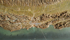
The video provides several clips of the Model, but nothing prepares for the actual thing. Viewed from an elevated walkway, the Bay Area water system spreads below over the size of two football fields. Inside the Model, 1,000 feet is scaled down to one foot of painted concrete, adding up to a total of 286 five-ton, 12-by-12 foot slabs of painted concrete. The entire space smells lightly chlorinated.

Sponsored

A number of conversions combine to create an accurate representation of the Bay Area’s water systems, both spatially and temporally. A full tidal cycle (about one day’s worth of tidal action) occurs every 14.9 minutes in the Bay Model. Too slow to be seen by the naked eye, the rising and falling water level is produced by allowing more or less water in or out of the “Pacific Ocean,” a placid lake in one corner of the building. Another alteration takes place in Suisun Bay, which didn’t quite fit within the confines of the WWII shipyard warehouse, demonstrated by hinged map with the directive “Make It Fit!”

While the intensely analog nature of the Bay Model may now seem horribly outdated, it was crucial to the current state of Bay Area water management. In the 1940s, John Reber (a theater producer and self-taught hydraulic engineer) proposed blocking the flow of river water through the Delta and into the Bay to create freshwater reservoirs for consumption and farming. He also advocated the reclamation (read: filling in) of a further 20,000 acres of the Bay, a massive reshaping of the landscape. To test the Reber Plan, Congress allocated funds for the construction of the Bay Model, a smaller-scale and far less risky endeavor. When the plan was deemed unfeasible, the Bay Model proved itself an indispensable tool for evaluating changes to the Bay Area water system.

I learned all this (and more) from the Model’s accompanying text. Such lessons are overwhelming in concert. While different stations within the warehouse offer useful answers to “Where Does the Water in the Model Come From?” and “Does the Model Ever Leak?” other displays resemble Lite-Brite patterns more than valuable tutorials in water flow. Information is delivered in every possible way, from dramatically arranged telephone stations and and charming groupings of laminated newspaper clippings to button-activated multimedia features and “video journeys.” The narrative voice of the Bay Model is a bit scattered, but it means well.

While I cannot guarantee you will find the Bay Model’s educational efforts interesting, there is no question that the space is a visually arresting one. Even if one were to read nothing, press none of the inviting buttons, and twist none of the knobs, there is still the basic pleasure of finding familiar landmarks and coastlines. Of wondering what goes on in all the mysterious offices overlooking the model. Of thinking about a building labeled “TIDAL HUT.”

As a resident of the Bay Area, I must confess I think of the land portion of that area far more than the Bay itself. While I value living so close various bodies of water, rarely do I consider the shape of its edges and the constant effort that goes into maintaining, say, shipping channels of the proper depth. Except for those infrequent moments looking out a plane window, it is rare to see the Bay Area in its entirety. With behind-the-scenes access to the ongoing balance between human needs and environmental concerns, the Bay Model provides that view at a tangible yet awe-inspiring scale. Don’t wait for a Sausalito-based scavenger hunt. Visit the Bay Model today!

The Bay Model is free and open to the public Tuesdays through Saturdays, 9am to 4pm. For more information visit spn.usace.army.mil.

lower waypoint
next waypoint
Sunnyvale’s Hottest Late-Night Food Spot Is the 24-Hour Indian Grocery StoreYou Can Get Free Ice Cream on Tuesday — No CatchThe World Naked Bike Ride Is Happening on 4/20 in San FranciscoCalvin Keys, Widely Loved Jazz Guitarist With Endless Soul, Dies at 82Three Eye-Opening Documentaries You Can Stream Right NowHow Low Key Became the Coolest Skate Shop in San FranciscoTicket Alert: Charli XCX and Troye Sivan Are Coming to San FrancsicoHere’s What Bay Area Rappers Are Eating (According to Their Lyrics)A Californian Two-Spot Octopus Named Terrance Is a TikTok SensationA Gallery Owner With a ‘Let’s-Do-This Attitude’ Launches a Residency on Market Street